Adam Larson / Caustic Logic
The Frustrating Fraud
July 16 2007
last updated July 19
Connecting the Dots
 The initial flight path of hijacked Flight 77, as published in the days after the attacks, was largely a connect-the-dots approach. With no transponder after the terrorist takeover, and, we were told, “limited primary radar coverage” along the attack route, the return flight was not seen for a half-hour until it entered Washington airspace with its own radar. [1] The dotted line estimations published at this point sowed among the first seeds of suspicion over the attack. Was there a swap out there in the blind spot? As more evidence comes to light, all these paths have proven broadly accurate in that the 757 headed west, turned south over the WV-KY-OH border area, lost transponder, and returned, heading East straight to the Pentagon. Of the three maps above, Newsweek’s is the most accurate. USA Today’s path has a pronounced hump giving it a submarine profile, and Time’s map has the plane swooping north on its way back, crossing its outbound flight path, twisting the loop into an infinity symbol.
 The final line of the journey as it passed east of its origin at Dulles, seems from here uneventful. But in these same early days reports surfaced of a tight, controlled, implausible loop over eastern Virginia, thought by many beyond the reported skills of the alleged hijacker Hani Hanjour. Facing the west wall, Flight 77 was said to have turned 270°-360° to hit - the west wall – oddly enough, the side just renovated to withstand bombs and impacts, largely empty, and across the building from the Defense Secretary’s Office. [more on the radar blind spot and the impact location in "From the blind spot to the empty side."]
Few if any eyewitness accounts seem to address the grand loop, since it was simply too big to have been seen by any one person – the first part of it was perhaps too high to attract much attention, but as it approached the Navy Annex and continued to lose altitude, it attracted more witnesses in its last several seconds, by which time it was going straight towards the Pentagon’s west wall. With such published accounts as the early cornerstone of our awareness of the attack, this magical loop remained largely invisible, possibly another government lie.
 The overall uncertainty over 77’s approach lead many to accept this flight path as plausible to explain the final loop. It has Flight 77 flying south through DC’s restricted airspace with no White House defensive fire, headed towards Rumsfeld’s office before turning to hit the opposite side of the Pentagon, giving us the 270° turn so often cited. This map is quite wrong, understating the actual degree of turn by 60° and grossly misreading the original heading. [How this old map was arrived at and what’s wrong with it is explained separately in "the "old" 270° loop explained."]
The Radar Record
Among the too-vague early report was this from the ever-unbelievable Vice President Cheney, five days after the attack: "it entered the danger zone and looked like it was headed for the White House [...] Didn't circle it, but was headed on a track into it. [...] It turned away and, we think, flew a circle and came back in and then hit the Pentagon. And that's what the radar track looks like." [2] Five days later CBS News reported “radar shows Flight 77 did a downward spiral, turning almost a complete circle,” after which “the jetliner disappeared from radar at 9:37 and less than a minute later it clipped the tops of street lights and plowed into the Pentagon at 460 mph.” [3]
It was another month before radar specialist Danielle O’Brien, on duty at the Dulles ATC tower on 9/11, told ABC News’ 20/20 “it was an unidentified plane to the southwest of Dulles, moving at a very high rate of speed [...] I had literally a blip and nothing more.” As it headed towards the Pentagon, “it was just a countdown. Ten miles west. Nine miles west […] And it went six, five, four. And I had it in my mouth to say, three, and all of a sudden the plane turned away. In the room, it was almost a sense of relief.” But the turn continued until it was much lower and facing the same direction, after which O’Brien tersely summed up "we lost radar contact with that aircraft [...] and then the Washington National controllers came over our speakers [saying] The Pentagon's been hit.” [4]
O’Brien’s interview, aired in late October 2001, was accompanied by a radar screen graphic with a south loop of near 360 degrees off the east-bound flight as seen on radar screens. Seen briefly by millions, perhaps many thought this arc of dots just a guess or irrelevant, but in fact this same path would prove accurate and come back to bite them in the butt five years later. [Other than the red lettering, this picture is a direct screenshot from the program, viewable here.]

Official Reports: Zooming the Lump
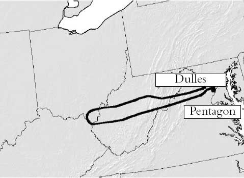 We were only allowed a slow zoom in on what that loop actually looked like in the chain of official reports. Initial NTSB studies were kept behind closed doors, being in the FBI’s jusrisdiction and exempt from FOIA requirements. But the correct loop is there in a map from the 9/11 Commission’s Final Report, released mid-2004. Note its general agreement with early reports, and also the little lump of ink on the south side of the terminal tip – that’s the final loop, unreadable in this bold line on an unnecessarily zoomed back map. This line is apparently taken from the NTSB’s Flight Path Study, made from FDR and radar data in February 2002, classified at the time but available to the commission and cited in the endnotes. The report explained how at "5 miles west-southwest of the Pentagon," Flight 77 "began a 330 degree turn." [5]
 That document was finally released via numerous FOIA requests in August 2006 and posted online from numerous angles. Finally we see a zoom in on the mysterious grand loop [see below]. First we see their overall flight path, printed big enough to show a silly little loop at the end [blue box], and also a detail of the loop all on its own page, faded yellow on a pale orange topo map [red box]. This is labeled in the report as “DC area flight path,” so possibly from ATC radar track, while the overall flight path above it is said to be from the matching FDR/radar data. [6]

The Black Box
Additional Flight Data Recorder information further verifies this loop. The Specilaist’s Factual Report of Investigation (SFRI), is an NTSB documented drawing exclusively on the full Black Box readings, also released in the 2006 rush. It has all functioning parameters graphed out for the duration of the flight, spread out over 17 pages; The basics -altitude, airspeed, and magnetic heading - are reproduced on each page. Here is the clearest extraction I've taken of this, edited to show a zoomed-in final minutes reading. All lines and values are accurate according to the bars at right and left. [7]
 The story it tells is that at 9:34 Flight 77 began a remarkable thhree-minute turn just short of the Pentagon. The change in magnetic heading is graphed - as it approached DC with a general heading of about 95-100° magnetic –after a slight adjustment to the north and back at 9:31-32, the plane begins its loop at 9:34 – for about three minutes it turns south and then near-full circle to the west, north, and finally settling, at about 9:37, on a northeast heading of 70° magnetic, after completing the 330° turn and descending about 4,000 feet in the process, the last 45 seconds were a straight shot at that heading and a steady descent to roughly zero altitude at 9:37:45.
 Here is how to read the headings on a map - apologies for the fruit-flavored style if that offends anyone’s sensibilities. The angle and color tells headingat a given mement, tehe direction the nose is pointing. Magnetic heading, which the FDR works with, are just about 10° higher compared to headings based on geographic north, since the magnetic north pole at that time was about ten degrees west of the true north. Read zero also as 360, due north, green. Here the plane starts out deep blue – due east, roughly 90° from north, 100 mag on the FDR - and its final heading is about 60°. Add ten to get magnetic, and this is what the FDR says – 70°.

The erred NTSB working copy animation, used by Pilots for 9/11 Truth, matches as well the official loop; their “final maneuver” video starts out at 9:34:03, turn just starting, and straightening out from 9:36:45-9:37:15 The onscreen mag heading dial roughly matches the other FDR data, settling on 70 after the loop – but of course the on-screen animation somehow ends up twenty degrees off from that, which is what places it “too far to the left” to have impacted the Pentagon, as the Pilots discovered…
Sources and editing: Coming
[1] Phillips, Don. “Pentagon Crash Highlights a Radar Gap.” Washington Post. November 3, 2001. Page A06. http://www.washingtonpost.com/ac2/wp-dyn?pagename=article&contentId=A32597-2001Nov2¬Found=true
[2] "The Vice President appears on Meet the Press with Tim Russert." Camp David, Maryland. September 16 2001. http://www.whitehouse.gov/vicepresident/news-speeches/speeches/vp20010916.html
[3] "Primary Target - THE PENTAGON." CBS News. September 21 2001. http://www.cbsnews.com/stories/2001/09/11/national/main310721.shtml
[4] "`Get These Planes on the Ground' - Air Traffic Controllers Recall Sept. 11," ABC News, October 24 2001. http://web.archive.org/web/20011024150915/http://abcnews.go.com/sections/2020/2020/2020_011024_atc_feature.html
[5] National Commission on Terrorist Attacks Upon the United States. The 9/11 Commission Report. map: p. 33. Citation of Flight Path Study: Page 459, source 59 for chapter 1. Explanation of the loop on page 9.
[6] FPS
[7] Specialist’s Factual Report of Investigation: Digital Flight Data Recorder . NTSB document number: DCA01MA064 National Transportation Safety Board, Vehicle Records Division. January 31 2002. PDF download link: http://www.ntsb.gov/info/AAL77_fdr.pdf


