Showing posts with label Arabesque. Show all posts

Tuesday, March 18, 2008

OBSTACLE? IMPOSSIBLE.

OBSTACLE? IMPOSSIBLE.
WHY THIS ANTENNA THING IS A NON-ISSUE
Adam Larson / Caustic Logic
The Frustrating Fraud
March 18 2008
last update 3/23 3am


Okay, so here’s my response to Rob Balsamo’s new masterpiece Arlington Topography, Obstacles Make American 77 Final Leg Impossible. Yet again, we hear, some things taken together with other things have again proven the official story of the Pentagon attack is physically impossible. He dated the piece March 13 so he could say dramatically “"Beware The Ides Of March" could not be a more appropriate introduction to this article as it appears the government story regarding the events at the pentagon is officially dead.” Again the merry-go-round spins and in the end… again…. everyone disagrees still. I weary of this game, and this latest seems really a pathetic attempt. But it is in my area and people have asked my opinion, so I guess I need to cover it.

After infinite CIT re-posts of Pilots for Truth misfindings, it seems it was Rob Balsamo’s turn to catch them back. “Thanks to the hard work done by Citizen Investigation Team, they alerted us to review figures regarding topography and obstacles along the flight path of American 77 according to the government story. […] According to the government, American 77 final approach to the pentagon is depicted below.”
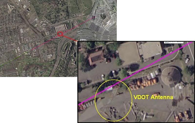
This graphic is not produced by the government, but by Merc Mercy CIT. I’m sure it’s fairly close to accurate, but is it close enough to say where the plane was relative to this 5-foot wide ‘obstacle?’ I’d have to say no. But Balsamo acts as if the government had drawn the line that took the plane right into or over this VDOT transmitter tower, 169 ft tall (including 6-foot antennas on top) above a ground elevation of 135 feet. He never explains whether or not this tower WAS hit, just takes a point right above it as a starting point. From this he did a bunch of math, with too many steps it seems to me, and decided that such a descent from above the tower to the light poles and into the building level would require 11.2 Gs of force.

“Conclusion = Impossible for any transport category aircraft to descend from top of VDOT Antenna to top of pole 1 and pull level to "impact hole" as reported by the government story and seen in the DoD "5 Frames Video". 11.2 G's was never recorded in the FDR. 11.2 G's would rip the aircraft apart.”

I don’t intend to get into the math of all this, but John Farmer’s response is worthy of note: Mission impossible He found that Balsamo’s numbers didn’t add up to what he said they did, double-checked and found the g-force would be 3.5, not 11.2. “So “impossible” is not the word I would use Rob.”

Then he also passed on the video interview of witness Ed Paik explaining how the antenna on top was indeed damaged. Somehow this was not included in Balsamo’s post even though his sources were there when Paik said this. Ranke had to add after that indeed Paik said this but, as Ranke explained back in 2006 “he just deduced this because he saw them working on it the next day. We confirmed with the VDOT employees that the antenna was not clipped.”

This maintenance was routine then, and just happened to occur one day after the plane flew right over it. Says CIT. Perhaps… But doubts remain; the only photo anyone’s yet found that shows the tower on 9/11 after the strike, by Steve Riskus, shows some hints of a damaged antenna, as Farmer discovered. I can see this, the deformation of the shorter right spire, and it's an intriguing possibility; as Arabesque puts it:

""We have a plane that many witnessed flying by the area the previous day. We have the flight data recorder suggesting that the plane might very well have been in line to hit the top of the tower and continue its trajectory; impacting the light poles and the Pentagon. We have a witness who confirms that the plane was flying at the approximate height of this tower and that he suspected that it was damaged from an impact with the plane as it was being repaired the next day--the two meter antenna replaced by a repair-man. If it can be proven that the tower was damaged from the incoming plane, this would be another compelling piece of evidence for the south of CITGO gas station approach and impact into the Pentagon; corroborated by the flight data recorder no less.""[e-mail]

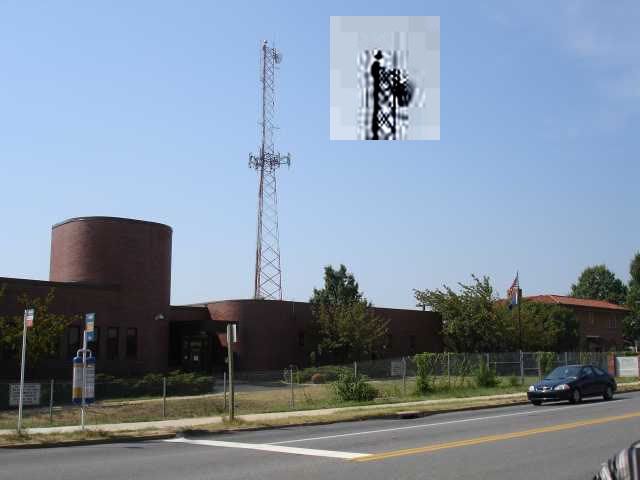
However, this photo is just not clear enough for me. It’s essentially a needle in the distance, lost in a digital haystack. Any slight artifact will warp it too easily. In fact when people were TRYING to take a good picture in 2006, it almost looks like one antenna is missing entirely (below). I don’t think we’ll ever see a picture clear enough to say unless it was taken by the repairman, but I'd need to see better evidence it was NOT damaged before I'd believe that either (a copy of the work order for 9/12 stating the reason for the repair, for example). I’m leaving this aspect ambiguously undecided and moving on.
Whether the plane flew just over this spindly 'obstacle' or nicked its top, the descent issues are roughly the same - a descent from 305ft MSL to about 35-40, a total non-linear descent of 270 feet over a span of about 3400 feet. This means a descent of 165 feet from FDR last frame before the antenna and another app. 235 feet dropped from the antenna to the first light pole in the same rough distance but at higher speed. I'm no pilot, but a lower altitude at the tower makes a bit more sense.

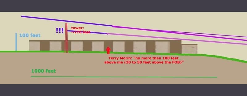
For a different aspect on aircraft height, Terry Morin at the Navy Annex (aka FOB) placed the Boeing “essentially right over the top of me and the outer portion of the FOB (flight path parallel the outer edge of the FOB). Everything was shaking and vibrating, including the ground. I estimate that the aircraft was no more than 100 feet above me (30 to 50 feet above the FOB) in a slight nose down attitude.” For this I’ll us a graphic I used earlier when CIT argued a similar problem relating to descent angles and impossible stuff, just updated a bit. It’s a panoramic graphic so here’s the right half with a reasonable descent angle to the light poles and impact.
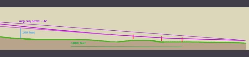
And here is the important half, with the tower added to scale and cross-sectional placement. Oddly, my previous lines extended back take it over the tower neatly, but that’s a pretty steep descent. It looks like it would cause 3.5-11.2 Gs, considering the range offered so far. If we take Morin’s account as closer, which I tend to, it had to be much lower, which offers a more reasonable pitch, but takes the plane well below the top of the tower. This means an impact if Merc’s government line is accurate.
But I doubt it is. Flight paths aren't perfectly straight. They wiggle a bit, especially I would think at high speeds in the lower atmosphere. In another post I established that the witness record and physical damage best fits with a moderate left bank over the Navy annex, and likely a slight left curve to the flight path between the Navy Annex and Route 27 where it leveled slightly, with an apparent left bank of about –5-6° evident in the impact damage.

So considering all we know here is a proposal I offer: I had first favored the purple swerve, but after reviewing Morin I'm betting on the green line at the moment, or else the purple one.
- Final trajectory by pole and building damage - ≈ 61°
- Final FDR heading ≈ 59.9° (these are shown in red at the corners).
- The big yellow dot at lower left is the last reported position in the FDR data we have
- The yellow line a straight shot from there to the damage path. This indeed crosses over or within a few feet of the tower, probably too close for comfort if it weren’t high enough.
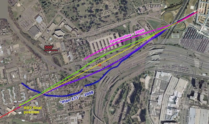
Before going graphically away from straight lines, I added for comparison two non-straight attempts to explain the ‘official’ evidence. In magenta a 2004 estimate by Jean-Pierre Desmoulins with a notable wiggle to it. He’s a pilot. Also in dark blue is an estimate by “Plan 271,” based on eyewitness reports from Dawn Vignola.

The two variations I’ve traced in green and purple are the most moderate explanations. While the green path fits best with Morin's account, the purple one is perhaps more consistent with left bank clues. Note the scale here – 500 feet is just a short line - and that each path is traced along the fuselage centerline. To clear the tower north or south it need only pass 62 feet away (124-foot wingspan). On closer inspection they pass about 250 feet from the tower, so I could’ve made them much milder. In fact I'm thinking the best fit is about 1/3 from the yellow line to the green one, with perhaps a left turn starting earlier, just after the tower, giving it a noticeable left tilt as it approached Route 27.

But even this extreme, both visibly look possible and reasonable – connecting two nearly identical trajectories with a gentle curve away and back, and still safely north or south of the tower. Altitude options open up. Either way, it looks like a reasonable avoidance procedure of a minor object on the attack path. if it were that low, which the witnesses and FDR seem to indicate.

Purple swerve - Max angle required to avoid the tower ≈ 68°
Min angle required to avoid the tower ≈ 53°
Green swerve - about the same
Time frame: app 6-7 seconds from the yellow dot
Any pilots? How impossible is that?

This is a non-issue – a needle of an obstacle that would be missed almost by definition if the path were anything other than perfectly straight, which it probably was. It’s also a non-issue because all previous attempts to ‘prove the official story impossible’ have failed under the test of verification. All that’s happening here is the wrong data being looked at the wrong way and attributed back to reality in a repeated straw man maneuver that’s giving many a case of hay fever. There is nothing impossible about what happened, and as a relative non-issue that seems prohibitively tedious to either prove or debunk I’m not even taking this one to the forums.
Update 3/23:
I took it to the forums a little. 9/11 Blogger (comments page 2) - Above Top Secret.com

update 3/19:
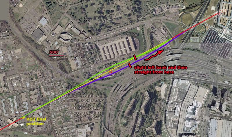
note: in the graphic above I somehow screwed up the 500' scale, making it actually represent about 400 feet. Luckily my margin was still wide enough that these mild swerves are still a fit, both passing well over 100 feet from the antenna tower.

update 3/21:
I just located again Russell Pickering's take on Paik's antenna memories from the old old LCF, 9/10/06:

"I went to the VDOT to confirm it hadn't been hit. It had not. Then in Edward's interview I asked him if he actually saw it hit the tower and he said no. Then I asked him if it hit the solid metal part of the tower and he said no. What he said was that it hit a smaller antenna of 2-3 meters in length on the top. He ended up telling us the reason he thought it had been hit was because he saw somebody up on the tower working the next day.

What had happened then is he incorporated a conclusion from something he saw later into his memory of the original account. The real story is that when the FBI took over the VDOT as a command post they added antennas to the tower for communication."
[emph. mine]

So it actually was not a coincidence people were up there the day after a plane flew by there. There was a direct cause and effect relationship between the two, as that plane had turned the area into a major hurking crime scene of the utmost national security importance. They needed many things, including communications. And perhaps the old antenna was also coincidentally damaged by the plane and replaced at the same time. That certainly can't be ruled out and in fact may well be the case judging by the new evidence coming to light. And that would certainly be another problem for the north path fly over story.

Update 3/23: CIT's take was not coincidence of antenna work but rather that it was not damage-related. They seem the feel it was the military, not the FBI, who put up the new antenna. And we have further confirmation that it was not damaged: John Farmer has confirmed the fact again with the VDOT smart center manager. He offered no details beyond "that was not true!," but as Farmer noted "if anyone should know it would be him (he would have to approve the replacement cost since he was the manager)." [e-mail]

Tuesday, February 12, 2008

C-130 FLIGHT PATH VIDEO

C-130 FLIGHT PATH VIDEO:
NO CONTRADICTION EXCEPT WITH CIT
Adam Larson / Caustic Logic
The Frustrating Fraud
February 12 2008
update 9/8/08


I posted this at Youtube a wile back, my most ambitious video yet, almost a mini-documentary in itself. I've been hazy on the details of the C-130 at the Pentagon, but now that Citizen Investigation Team is pushing an interpretation of it to bolster their overflight path construct, I felt a need to dig in to the available data to see what truly contradicted what. Craig and Aldo believe pilot Steve O'Brien's verbal accounts contradict the radar data (fraudulent, of course) and support their witness-compilation flight path for 77, as explained at this LCF thread (comments from "Deleted User" are from me - I asked to have my LCF account closed, not realizing how drastic it would look). To understand my reasons for assembling this, it might help to read the CIT link at top and/or this post at my blog. See also this attempted discussion thread at Above Top Secret.com.

This is the result so far: a collage of all the mutually-supporting evidence of where that plane flew and where and how it interacted with Flight 77 on its way to its fate and in its pass near the Pentagon after that. I'm able to incorporate on-the-ground witness accounts, on-site video, radar animation, and O'Brien's own words and gestures, as well as some of Aldo's own spoken words. Nothing in this video contradicts the other parts.

Online Videos by Veoh.com
Page link - Veoh

To understand the video itself, especially regarding its lower-than-hoped resolution, refer to these graphics and additional notes:
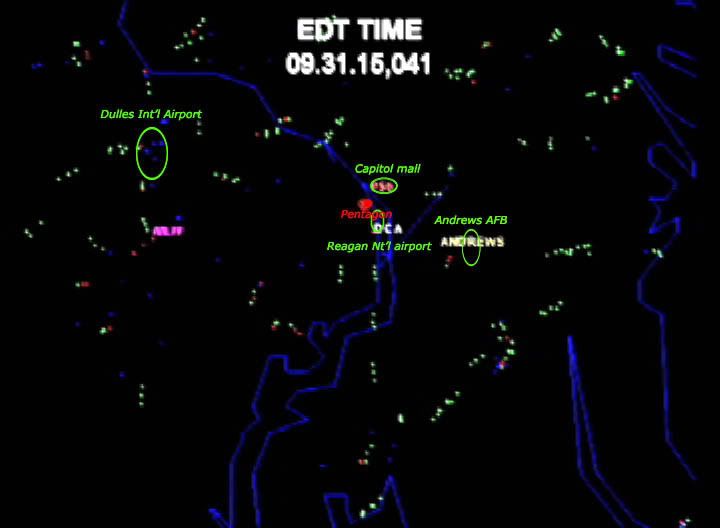
This is the radar screen labeled, which is unreadable in the video. The raw radar data was released to US researcher John Farmer, and this animation created by Italian researcher Marco Bolletino, downloaded from Farmer's AAL77.com.
first frames of Anthony Tribby's amateur video of the post-attack scene, taken almost due south of impact. The smoke has not reached the top of the screen, putting this at somewhere from, say, 10-30 seconds after impact. The "UFO" I think is the C-130 emerges from behind the plume one minute and 45 seconds after this frame. It barely comes through at all in my video, and doesn't even look too good in the higher res original. The frame below is the clearest of the object, zooming in on it as 2:04.

The object is filmed from a moving position in the range shown below, ESE of the impact point, judging by passing landmarks. After being visible for 23 seconds, it disappears again behind the plume. Its overall direction of movement seems to be left-to-right (S-N) at first, curving away and departing along the rough line of sight from there (WNW). The red arc below shows the rough direction of flight, but does not attempt to re-create the exact placement or scale of the flight path. [update: any idiot who takes this as evidence of the location of the plane or the size of the arc is... an idiot. The ANC witnesses are READ as placing it right over the cemetery doing the same curve the radar shows but a few hundred feet off, and that this coincides with my curve here means nothing. I wasn't even trying to decide what it was over.
I haven't bothered downloading the special software and figuring out the raw data, but by Bolletino's animation, this is about what radar shows the C-130 doing approximately two minutes after the attack.

The departure from Andrews shown on radar is said by CIT to fatally contradict what O'Brien himself says; he flew "north and west" and had "a beautiful view" of the Capitol Mall as they crossed the Potomac on "the south side of the mall." [see links above] The departure on radar has him taking off north and then nearly west, crossing the river well south of but probably within visual range of the mall. Close enough for me. The departure shown is also a match for one of the standard patterns used at Andrews, the "Camp Springs One" departure. [explained by Boondoggled]

That wasn't even in the video, nor was this bonus, for folks marveling over the mystery plane (left) with lopsided engines captured in a photo from 9/11 and previously passed off as the C-130. Here is that plane compared to a 4-engine C-130. Like a low-resolution mirror.

Sunday, December 9, 2007

"OLD" 270° LOOP EXPLAINED [FINAL]

THE 270° LOOP AROUND RUMSFELD
WHERE DID THAT COME FROM?
Adam Larson / Caustic Logic
The Frustrating Fraud
Posted July 25 2007
last updated 12/9/07


Note: This article deals with Steve Koeppel's loop map only. Arabesque has also posted an excellent post partly on this article, related with the three planes-confusion (FL77, a C-130, and an E-4B "doomsday plane," all verified in the area at the time), later expanded to cover other areas.
Note 12/9: Steve Koeppel himself (I presume) has popped in here to help explain some things (see comments below). "I did state that I had been an Air Force and Reserve navigator (I am NOT pilot in the military! Would somebody clear that up?!?)" Yes. Koeppel was not an Air Force Pilot as cited by The Power Hour. He was an Air Force navigator. "AT THAT TIME (early 2002) my intent was get suggestions on why there weren't any tourist photos (of Flight 77) [...] I made no claim to creating the unimpeachable analysis," he clarifies, "nor was that my intent; that's why I put so many qualifiers in my post." Good. Among the scant evidence he called on to create his path, one escaped my detectors and still does: "after disappearing from the radar scope the aircraft had had reappeared approaching D.C. from the north and was thought to have been aiming at the White House..." See below for full comment.
---
For years after 9/11, as controversy swirled over the details of the Pentagon attack, a working draft of the highly suspicious reported 3/4-circle loop in the flight path became widely used to cast doubt on the official story. This grand loop over Washington became one of the unifying points of agreement between Hunt The Boeing Pentagon no-planers and remote control-757 advocating “plane-huggers.” The general gist was eloquently summed up by Nila Sagadevan in early 2006:

“[T]his fanatic Muslim kamikaze pilot […] found that his “missile” was heading towards one of the most densely populated wings of the Pentagon—and one occupied by top military brass, including the Secretary of Defense, Rumsfeld. Presumably in order to save these men’s lives, he then executes a sweeping 270-degree turn and approaches the building from the opposite direction and aligns himself with the only wing of the Pentagon that was virtually uninhabited due to extensive renovations that were underway” [1]

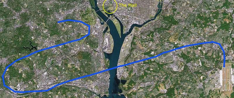
While this sounds compelling, the flight path he’s talking about never existed. It was bolstered and seeded in the movement, above all, by this map:Those who cite this precise angle of turn, point out the lack of White House defensive fire as the plane passed within a mile or two of it, or of the plane going out of its way to avoid Rumsfeld’s office, for which it was headed, are probably referring to this map, if to anything specific. Russell Pickering’s Pentagon Research.com used it to illustrate; “you can see where the White House was passed.” He also carefully cited the map’s originator, which makes it easy enough to look up and double-check. Author: Former Air Force Pilot Steve Koeppel, Palm Springs, CA [2]

This led me to Koeppel’s undated piece, from way back, some time in 2002 it seems (it was mentioned by Hufschmid in Painful Questions, released 2002). The map and explanation of it were hosted originally by The Power Hour, producers of 911 In Plane Site, which is among the worst 9/11 videos ever, often dismissed as a too-long joke on the Truth Movement. Whatever the merits of his hosts, Koeppel's piece there explained how he reasoned out the map; none too promising is how he starts out with (apparent) inexplicable ignorance over the general contours of the flight:

“It was fairly simple to find the WTC routes, but I have yet to see a map showing the route flown by the aircraft that was said to have hit the Pentagon. So I read some of the reports and put together the attached maps. […] I'm surprised that I haven't seen this map — or ANY map — of the Pentagon airplane's approach. Given all the information that we were deluged with in the weeks after the attacks, it surprises me that this graphic was omitted.” [3]

The flight path of Flight 77 was not omitted by any measure, and it was not hard to find – even I knew the general outline of the flight, as : first published in Time, Newsweek, etc in the days after the attacks. Yes, the return path was a dotted line back then, estimated obviously, and too vague yet to show 77’s final loop, which was apparently his main question. But all these paths have proven broadly accurate in that the 757 headed west, turned south over the WV-KY-OH border area, lost transponder, and returned, heading east straight to the Pentagon. “Guardian” was one of the few that noted of Koeppel’s path “that this is a very strange flight path for an aircraft coming from the east and planning to crash into the Pentagon.” [4] It’s at least as odd for Flight 77, which was coming in from the southwest and finally impacted from the southwest, to wind up swooping down on the Pentagon from the northeast as in Koeppel’s map.

As an ill-fated aside before explaining his sources, Koeppel pointed out “what's surprising is how many news sources got the information wrong. For example, look at this graphic from Reuters, which has the attack on the wrong side of the Pentagon:”
Above is the graphic he used [right-click, new wiindow to enlarge], labeled “The Pentagon Attack” and featuring a six-point timeline of events, along with a grossly incorrect impact point shown. What’s at least as surprising, in my opinion, is where Koeppel explains “I based my map of the attack path on a description of the attack (see Pentagon Attack) which said the plane was initially picked up on radar east-southeast of Dulles heading at high speed toward Washington.” [5] Red flag! He introduces the erred Reuters graphic, and then tells us his whole analysis is based on a single account, and it’s this same graphic.

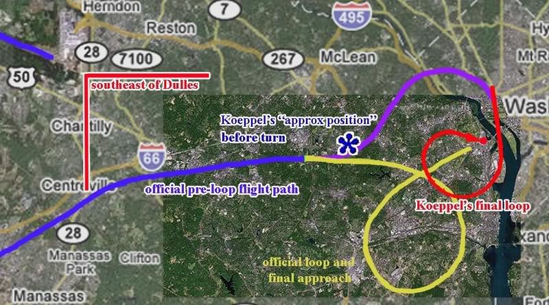
Another wrong point in it he (understandably) failed to catch was its understatement of the loop by 60° – it was indeed to the right (south) but was actually 330°, nearly full circle, a descriptor widely used outside of the source he chose. As for how he came up with the southward swoop, Koeppel explained it as starting from “the 270 degree right turn” leaving him “puzzled.” A “near-circular” turn to the right, off an approach from the west, to hit the Pentagon at the final angle he gave no clue of being aware of, Koeppel might’ve guessed something like the official and logical connecting loop (here in yellow). Instead, he decided to bring it in from the north; “I realized that [the 3/4 loop] would provide a simple set of landmarks for the pilot. Just intercept the Potomac River north of town, follow it south until you see the Washington Monument or Capitol,” and then, as the Reuters guy said, make a 270 degree right turn and hit the far north edge of the west wall at the fourth-floor level. So thinking like a novice pilot, he found an arbitrary 270° line of landmarks in that area that might guide one to the target, and then presumed that to be the most logical flight path that he felt “meets all the conditions in the description.” Below is a map that helps clarify that his entire red arc is indeed east-southeast of Dulles, barely, and this seems to be a plausible path – if we disregard the official and logical flight path up till then (blue).

If the final loop Koeppel arrived at (red) was to be connected with the official story path (blue), that would necessitate the purple arc, or something similar, to connect the two. Since he was generally aware of the plane's position before turning (blue asterisk in the center of my map, actually pretty close to the official flight path, and nowhere near "the Potomac river north of town"), he in fact was implying the purple arc. However, he fails to explain or illustrate this turn to the left/north around and over DC, which is nowhere in his Reuter’s graphic or any other account. He made no mention of the full implied loop of roughly 400° from there needed for his loop to work.

In short, despite his ignorance of “ANY map of the Pentagon airplane's approach,” Koeppel was able to place the plane properly before its turn, but then invented the wild purple and red maneuver and only explained and illustrated the second half of it. He called this analysis and map “my contribution to the effort to try to make sense of an insane event. I don't know if it adds clarity or static, but it seems a part of the puzzle that has been missing.” [6] Looking at the method that gave us that half-map, it was clearly static he added. What’s surprising is that no one apparently caught on and this map became almost gospel. It was so widely used and believed to explain the oddity of the Pentagon attack (which is still odd enough) that it was interpreted by “Guardian” as possibly official; “the claimed flight path of flight 77 over Washington. […] In reality, flight 77 never existed.” [7]

The real loop, 330° to the south off an easterly approach, was new to some of the top 9/11 Pentagon researchers in mid-August 2006. At the Loose Change forum, Killtown showed the NTSB yellow-line loop map, seen in the just-released Flight Path Study. He labeled this as “new,” compared to Koeppel’s map, labeled “old.” Pickering, who had promoted the “old” map by featuring it on his site and working it into his other material, responded “the new flight path data does not change everything,” but it did help indicate to him that “I have a lot of re-writing to do these days!” Another member noted Pickering’s reliance on Koeppel’s map, and wondered of Koeppel “what he based his information on?” The question was not answered there, but I hope this analysis helps shed some light on the subject. [8]
---
More people who had fallen for it at some point (besides me, not that I even looked close until now): Jim Hoffman at one point used Koeppel's map to illustrate how a "Spiral Attack Maneuver Avoids Top Brass."
The bastards at Judicialinc captioned the map "NORAD's story that Hani Hanjour flew a 757 doing 600 MPH at 7000' and went into a 270 degree decending turn and hit the Pentagon, is absurd."
---

Sources:
[1] Segadevan, Nila.“The Impossibility of Flying Heavy Aircraft Without Training.” Looking Glass News. Feb 20, 2006
http://www.lookingglassnews.org/viewstory.php? storyid=5115
[2] Pickering, Russell. “Analysis of Flight 77 Flight Path” Pentagon Research.com. http://www.pentagonresearch.com/017.html
[3], [5], [6] [Koeppel, Steve. Analysis of Flight 77: Flight Path by a Former Air Force Pilot.” The Power Hour. Undated. http://www.thepowerhour.com/911_analysis/steves-analysis.htm
[4], [7] Guardian. “Flight 77 and the Pentagon. What Really Happened?” Undated. http://guardian.150m.com/pentagon/small/911-flights.htm
[8] Pickering, Russell, Terry Zarzoff, and Killtown. Comments posted August 12 2006. Loose Change Forum -> The Pentagon -> "New Flight 77 Path Different (of Course)." http://s15.invisionfree.com/Loose_Change_Forum/ar/t10366.htm

Tuesday, December 4, 2007

ARABESQUE ON THE ABSURDITY OF CIT ANTICS

ARABESQUE ON THE ABSURDITY OF CIT ANTICS
Adam Larson / Caustic Logic
The Frustrating Fraud
November 26 2007 1:45pm
last update 12/7 2pm


Fellow blog-format 9/11 researcher Arabesque has been up to some good works on the Pentagon lately; besides his Pentagon Flyover Theory RIP (actually more a short catalog of the visual clues that there was no flyover), now he’s posted CIT, Craig Ranke, Aldo Marquis, and the PentaCon Flyover Theory: Origin, Debate, and the ‘Smoking-Gun’ Anti-Controversy, an exhaustive and worthy critique of Ctizen Investigative Team. Primarily using the words of CIT and their detractors, Arabesque examines and exposes the two-man core team (they also have a third member I hear, though I don’t know who) that produced The PentaCon and the reborn ‘proven’ fly-over theory, based on eyewitness reports (first-hand confirmed, multiple-corroborated, recorded, and still wrong IMO) and their own initial (and incorrect IMO) hunches. He addresses some background, their theory’s origins, the logic of and evidence for a flyover, and their methods of debate and evasion. If there is one source you’d like to read on CIT’s approach, this one is perhaps the best and most exhaustive.

Among many quotes backed by dozens of links, this Russell Pickering gem from the old Loose Change Forum caught my attention. As someone who has worked very closely with CIT, his insights are extra valuable, so we must take note when he tells Craig, as he did shortly before The PentaCon's release:

“When I watched you guys bending reality in person conjuring up black operations for everything that didn’t agree with you - I saw where this was going. When your partner tipped over and the forums melted down - it was clear what the motives were. But I do have to admit your dissociation from reality has exceeded what I thought possible… Ego is a blinding force - but spreading this as gospel and irrefutable instead of adding it to the body of evidence truthfully and honestly is .........”

With all the emphasis CIT places on the validity of witness testimony as strong enough to counter the wider confluence of evidence, their take regarding the account of Lloyd England, the cab driver whose windshield was pierced by a light pole fragment after the plane sent it flying, is one ironic sore point for critics. Perhaps since his case contradicts their theory (though officially because it’s internally inconsistent) they feel Lloyd is a government plant and the ‘first known accomplice’ of the planted light-pole cover story. Arabesque found this about their villain:

“Dylan Avery observed of the CIT investigators, “anyone who's watched [CIT’s] behavior on our [Loose Change] forum knows exactly where [they] stand. ‘The generator damage? It was faked! The light poles? They were faked! These eyewitnesses? They're lying or agents! Bla bla bla...’ Aldo's tirade in the TNR pretty much seals the deal. You think Lloyd England is a government operative, ‘THE DEVIL’ as Aldo put it.” Ranke attempted to justify calling Lloyd the taxi cab driver a “devil” by saying, “if ‘demon’ isn’t a fitting description for someone willingly involved what is?”
---
Note:
There has been some confusion over who said and meant what in this case. Aldo's original quote, in a radio interview, apparently talking about Lloyd, was: "I can say I've spoken directly to operatives from the Pentagon attack. I have looked the devil in the eye." I had a phone conversation with Aldo yesterday where he clarified that he meant it in a more figurative sense; the overall plot - the attack, the cover-up, the whole sinister operation - was 'the devil.' Lloyd just the eye into which he peered and saw the darkness pulsing beneath. They maintain that he could be simply duped into playing along, and manipulated against his will into lying about what happened, and thus be simply an unwitting surrogate of the devil's works. But clearly he is a window onto the abyss, and that he happens to be the one witness whose south path testimony they've verified, they must place him in special quarantine, apparently rimmed with [metaphorical] theological barbwire.
---
Although I helped 'the hooded one' on this with some e-mails, most of what's in there he found himself and neither that help nor this post constitutes a full endorsement of every word in Arabesque’s piece. But it seems pretty much spot-on, and I agree with his closing line: “Aside from the weakly supported flyover hypothesis, whether intentional or not, the ridiculous antics and outrageous behavior of the CIT researchers are damaging and destructive to the credibility of the 9/11 truth movement.” Does that sound unfair? Read the piece, especially the harsh words/attempted intimidation against other researchers (Arabesque for one had taken more than his share) and also note this quick list of charges they’ve leveled against me in different forums (admittedly all after I first attacked them with strong language of my own):

Aldo and Craig have collectively accused me of using COINTELPRO disruption tactics, if not part of an organized program then a flunky wannabe or a brainwashed member of the CIT attack teams. They’ve accused me of ‘covering for the perps’ and trying to support the DoD’s innocence (which is irrelevant to my evidence-driven case). I’ve been accused of being on ‘the dark side’ (and invited to the ‘light side’), being a bad writer (often true), lying (a lie), using ‘deceptive’ graphics (not on purpose ever), using ‘irrelevant’ evidence, stretching the limits of credibility, being inconsistent with my own logic, making no sense/being ridiculous, and seriously arguing a conspiracy theory that isn’t even worth thinking about. They’ve distorted the points I've 'admitted' or 'conceded,' accused me of using a pseudonym to hide my efforts to smear them at the Loose Change forum just because they aren’t there to defends themselves (I happened to finally sign up just after they had been banned), manufacturing a LIHOP site at the last minute, apparently as cover for my anti-truth actions, and censoring comments on my blog (not true to any meaningful degree).

They have also proven able to see reason, to solidly show me wrong when I'm wrong (these are the cases where I've 'admitted things' - the other times it's their word against mine as to who was right). They have argued solid points, offered solid evidence, and given me and others credit where it was warranted and not threatening to their case. Why exactly they turn this reason switch off the rest of the time is anyone’s guess. I have my own hunches.

Thursday, September 27, 2007

DC/PENTAGON MYSTERY PLANE DISCUSSED ON CNN

DC/PENTAGON MYSTERY PLANE DISCUSSED ON CNN
Adam Larson / Caustic Logic
The Frustrating Fraud
September 26 2007


It's not brand new news, but a few weeks back, CNN aired this piece on the "9/11 Mystery plane," the large, white, 4-engine jet generally identified now as the E4-B "doomsday plane." I still haven't written anything on the issue, but it has come up time and again in my research, adding to confusion in eyewitness accounts and fertilizer to assorted theories that have come and gone. It certainly deserves a dedicated post here to add to or link to.

For additional information on this plane, see Mark Gaffney's interesting piece on this: http://www.rense.com/general76/missing.htm
Mr. Arabesque: "Pentagon Flight Path Misinformation, Stand-Down, War Games, and the Three Mysterious Planes"