Showing posts with label obstacles. Show all posts

Sunday, September 21, 2008

PILOTS FOR 2+2=5

September 21 2008
possible updates


For what it's worth, Pilots For 9/11 Truth recently released a new video based on math and stupid, that tries to say some stuff about the Pentagon attack. They're hoping to sell it, and so maybe have a breakthrough to push it with, like finally deciding on a theory of what did happen rather than just raising leading questions pointing towards no plane hit, held back out of "professional caution" and responsibility. LMAO. Please do not buy it, unless you support their long-running practical joke on gullible suckers. I don't even plan to watch it, but their talking points about the video focus on the presence of some serious math to correct their earlier egregious errors, months in the process of correcting. I'm fully capable of understanding the formulas I either failed to learn or forgot after High School, but only with the kind of time and attention I won't devote to facts whose only purpose is to debunk stupid shit I already know is wrong. Therefore, for those inclined to follow the math, especially those who lean towards believing the video, here is a link to John farmer's posts breaking down the "errors."

PFT Fantasy Flight Path and further analysis.

Myself, I don't feel like wasting any time on this. But if I change my mind, I'll plunk more stuff into this link. This is quite sparse, so I'm sure I'll have to add something.
---
Their G-Force on final descent analysis was relesed for viewing in a promo short video. Essentially, it’s a response to their epic 11.2 G error (admitted even!), first proposed in the Arlington Topography piece earlier this year. The correction was several months in the making, and only slightly different - 10.14G in the best case scenario. Now 11.2 Gs was waaaay off from what everyone more reasonable found, and it would appear the reason for the still-large gap is that peoples’ presumptions differed. His descent path is shown here in yellow, my notes added.
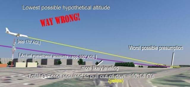
They presume, as I knew, a descent from just above the antenna tower to low enough to strike the first light pole by the time it got there. Two problems – it did indeed have to end where they show, but not start. The antenna tower is maybe 5 feet wide, and there’s no evidence if it was directly over, to the left, or to the right of it. All we know is close, and judging by eyewitness accounts, it was considerably lower than the top, so either left or right (and I’m banking on left, or north).
Terry Morin: “I estimate that the aircraft was no more than 100 feet above me (30 to 50 feet above the FOB) in a slight nose down attitude.”
Edward Paik: "It almost hit my roof [...] If [the plane was a] little bit lower… it would have hit the [Navy Annex] building almost it seemed like. [The wing] knocked down the antenna… the plane was in the middle of the road… that’s why it hit the Antenna."

There is some evidence the antenna may well have been damaged, but it's not conclusive. If true, this would leave PffT's initial altitude presumption nearly correct, and contradicts the lowness described by both Morin and Paik. What correlates is a plane tens of feet above the Annex roof, I'd say closer to 30-50 feet above rather than 90-110 above as PfffT decide is the "lowest possible." It would be laterally quite near the tower, near enough to seem to have impacted it near the top. This would put it over Columbia Pike, and and running near-parallel the building's edge. Numerous witnesses (including Paik via gestures and Morin via seeing stripes on one side) confirm the plane was in a mild left bank, with right wing high. If the plane passed north of the tower, the right wingtip would be nearest the tower and its antenna at the top.
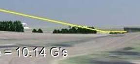
So, the descent from altitude, at the very least, cannot resonably be presumed as directly above the tower, greatly effecting the steepness of the resultant dive to the light poles. Second, and more important, the nature of the dive change is at issue – he has a sudden pivot, two straight lines bumping into each other, rather than like an actual plane's single uninterrupted parabolic curving movements. Ooops! My first comment was that this descent “has been sponsored by the letter L,” ala Sesame Street, and Reheat and other JREFers aptly took to calling it the ‘hockey stick’ descent. [Horatius did a funny comic strip on it] Apply sharp corners to “alleged” flight paths and you’ll force all change to one point and get unrealistic G-force calculations. Thanks PfffT for illustrating bad reasoning at work. Now just up the volume on the certainty language and demands for phone debates, and you can perhaps at least provoke people into wasting time, as a consolation prize for not being accurate.

Discussion on the G-Force video:
Pilots For 911 Truth
JREF
Above Top Secret
CIT forum

Sunday, July 27, 2008

LIKE TWO BULLDOZERS

NEIT 749 PHOTO SHEDS LIGHT ON DAMAGE PATH
Adam Larson / Caustic Logic
The Frustrating Fraud
July 27 2008


Whatever I think of some of John Farmer’s propositions, I have always appreciated his unparalleled use of FOIA and other channels to increase the body of available data about the Pentagon attack. Among the three dozen plus Center for Military History witnesses he’s obtained so far, one at least brought additional material aside from testimony. This witness is designated NEIT 749, a Helicopter Pilot with the Fairfax County Police Dept. He was not a witness to the event, and only saw the aftermath from the air. When he was interviewed by CMH in late April 2002,they also collected at least some of the officer’s photos, which Farmer was able to retrieve copies of, in mid-resolution, and share them at his site. He does ask that they be cited to Center for Military History / Fairfax County Police.

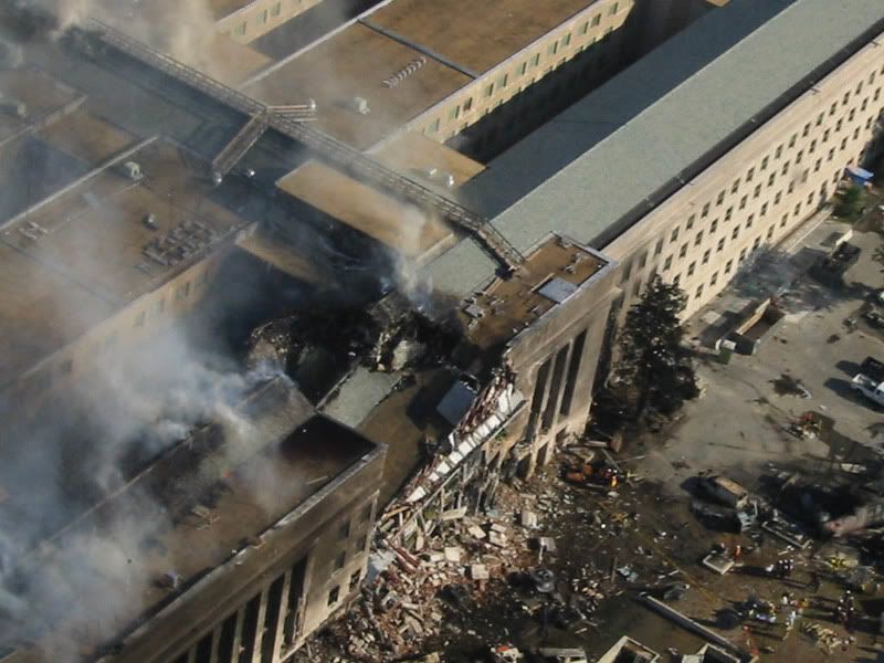
As far as I can see, these are all-new, never-before published images, 24 of them, most aerial long-shots of the damage and recovery staging areas. There is really nothing much revolutionary in the images that jumps out at me, but perhaps I’m just worn out on all this. One, image #100-0008, shows a new view of the downed light poles, partially assembled at the guardrail. I’m not sure yet if there are any new clues in that pile, that’s for later. For now I’m struck more by image #100-0028 (above), an early aerial shot from just north of the impact area and looking across the pre-building damage area at a unique angle.

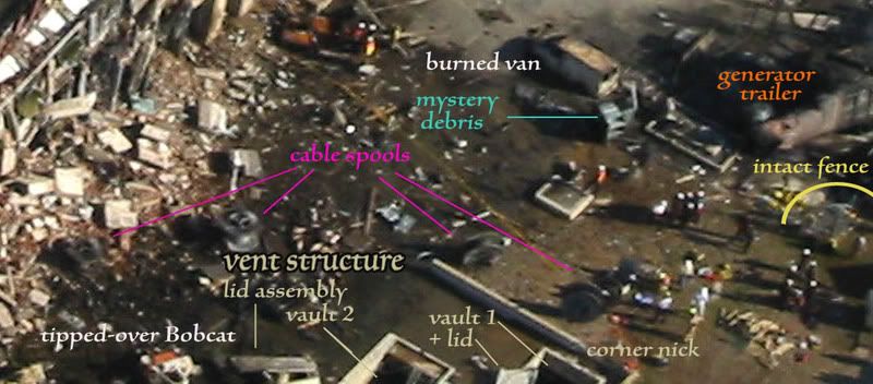
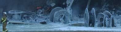
“Obstacles” of note labeled are in this enlarged crop, most previously identified in my “obstacle dodge post. For some stupid reason, a lot of entities have latched onto the cable spools as evidence against a large plane strike. I’ll look at that a bit below. The diesel-powered generator trailer and fence are of course widely noted as evidence for the right engine’s passage through that corner of the construction area. The ‘mystery debris’ I had previously thought perhaps part of the generator, but here we can see right behind it a concrete footprint (parked’ behind the van), to which something had apparently been attached. I looked at the vent structure in detail later, Its corner was famously nicked by the ground-level left engine, but hardly anyone has looked at the inside elements of this recessed structure. ‘Vault 1’ as I’ve labeled here was apparently scraped over, its hinged door pushed back and warped (see above post for closer side-photos) What I’ve here labeled vault 2 is probably the original resting place of the propped-open door assembly dented and hurled back. This is visible as a tent-like shape in many photos (here only half-visible). A tipped over Bobcat tractor as previously seen is even further behind that.

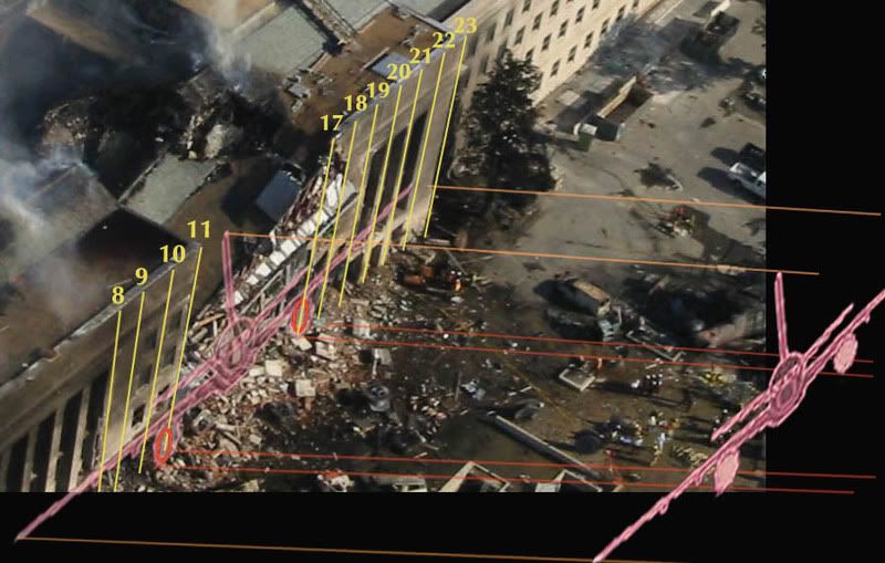
Without reference it seems a chaotic scene. But I have reference, and this photo also allows us a unique view of the area where I can line up the column lines and the “official” plane profile relative to them, and trace this back.

The tipped fuselage would have a clearance of perhaps ten feet at the right, and perhaps five at the wall. Its right side/wing faring a bit higher than the left. The famously non-tipped, non-damaged 6-foot cable spools furthest from the building were thus likely passed just over, and the one at center likely rolled a bit from the right – probably on wake just after the plane passed. The two further in seem to be spread away from the others right along the fuselage path as it descended, and tellingly, it’s these two that are tipped over and of course singed/burnt from the intense deflagration at impact, which they were in the range of.

Otherwise, the fuselage had little real effect prior to the building, and it’s the engine paths that are interesting here. All evidence puts their impact points roughly at column lines 11 and 17, the left engine at ground level and right engine a bit higher, These I traced back from impact in orange, along the ground (width app, slight perspective skew). Refer to the above graphic where the objects were highlighted and compare to these areas. The general excellent fit stands out, as framed by the fence damage and vent corner nick, and as everyone has noticed. What pops out here, aside from the curious lack of clutter in the actual engine troughs, is the precision of the lines marking their paths. The trailer and mystery debris on the right, both seem pushed aside just far enough to let pass a barreling multi-ton RB211 engine. On the left, the lid from vault 1, the lid assembly from vault 2 or wherever, and the Bobcat’s direction of tip all clearly follow the rough outer edge of the left engine’s swathe. Forward (on the plane’s path) and to the right or left, depending. Like two low-flying aerial bulldozers came in on the “official path” to fake us all out.

That is what some “investigators” would call a suspiciously precise forensic clue – like so much else about the attack, it just lines-up a little too “cookie cutter.” Would a real airliner fake an airliner’s damage so perfectly? Short answer: yes, it would, and it probably did.

Wednesday, January 9, 2008

VENT STRUCTURE DAMAGE

VENT STRUCTURE DAMAGE
Adam Larson / Caustic Logic
The Frustrating Fraud
January 1 2008
Updated Jan 15, 1am


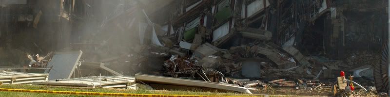
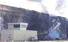
Among the low-lying evidence of a 757 strike at the Pentagon, as illustrated in this graphic from the ASCE's Building Performance Report, is a 50x30 foot ventilation/exhaust structure, presumably just renovated along with the rest of wedge one it was set about 75 feet away from. Joined to the building by underground tubes, and populated with multiple sub-structures, this area was directly beneath the left engine's purported low-level path of destruction. The vent structure is recessed, set into a slight hillock of that curiously unmarked lawn, so it might seem odd this is where the one part of the plane truly inches above the ground would leave a mark. It is effectively invisible in many long shots except as a pair of doors propped against each other, as in this Jason Ingersoll shot below. The area is surrounded by a low concrete lip, perhaps two feet high at its east side, and having suffered damage to the south wall (the left side above, the remaining portion visible as a wedge near the cable spool).
Up close and prior to foam application, in this cropped section of a Darryl Donley picture, we can see the south wall more clearly. The missing portion of wall is not inconsistent with the bottom edge of a 757-scale engine. To its left is the broken helicopter locator light, one at each west corner of the structure, and apparently both broken. Much of what lies beyond that here is in the further background, but the squared metal structure piled with burning debris is worthy of note - it almost looks like a miniature dumpster already filled with debris.

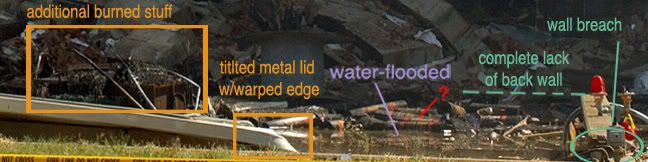
This valuable photo presented by Jean-Pierre Desmoulins (white labels are his), taken days later during the clean-up, and seen from above shows the south wall damage, lack of something, a naked squarish footprint surrounded by plywood at the entry corner (lower right). It also shows the lack of a back (west) wall, although it seems to cleanly gone, and I'm wondering if there ever was one. The 'doors' are still propped open but the whole unit at a different overall position and angle than seen earlier. The side facing the camera, on its far end, seems to be missing a corner, or is perhaps curved. Keep this in mind. Also note the labeled pile of debris to the right, including it seems that dumspter-ish thing also moved from its initial post attack position, and possibly piled with more debris from elsewhere. I've drawn on a sample plane trajectory (not verified as 'official' but it'll be close) that helps illustrate how both were moved, first by the plane/event, then again during cleanup. The possible limited foundation damage I've located, a foot or three below this, is also along the same line implied by the damage within the vent structure.

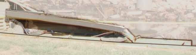
Here are some useful very close-ups of the doors, from three Ingersoll shots, in which it's clear they are propped open by a rectangular object off-cenetered between them (green-gray). Note different lip styles on each door, apparently designed for inter-locking, and a long section of black molding hanging off the left door at a smal bit of missing far corner(?). Note the hinge arm thing and possible power cables hanging under the right door. Hinge arm, unclear half-tube shape and more cables hanging under the left. In the top shot note also in the background a tipped Bobcat dozer/forklift, a possible clue to what was going on there at impact time. In the bottom shot note a pile of dark stuff on the right door, the 'grime line' previously discussed, and faintly the broken, bent section of lip, which is revealed as well in this Jocelyn Augustino photo from September 17. Note that with the object propping the unit open removed, the left side seems to sag at an odd angle.


This Ingersoll shot from after the collapse at 10:15 shows the doors or whatever exactly that structure is, the tops of the intact structures, and what seems to be the top of another higher structure, its right half pushed down and its edge twisted.

Steve Riskus' shots fail to clear this point up, and all shots I've seen show only edge and none show its top. All I can say is it seems to have a top of some size, its edge seems to be bent there, it's set far from the south wall, and at about a 45 degree angle between the two walls rather than square. Shots from as early as the night of September 12 show only the concrete footprint of it bracketed with the wood railing seen during cleanup, and so this photo I found (not sure who took it) seems to be from the late afternoon of 9/11 itself. Though washed out, it offers a unique view of the vent structure where we can see under this lid and also see the edge of its footprint (perspective is tricky here).

Using this and Ingeroll's best shot of the lid edge, I made this composite:

Again the overhead shot with more photo comparisons. Perspective issues can be tricky, and also remember things are moving around in the days after.
The new shot I located showing both the 'scorched debris' and the bent 'door' is a Jocelyn Augustino photo (index no. 1890, available at this link), cropped to save space. Looking at the metal, note the coloration, the perforrated square panels, relatively weak construction, griills and flap - ventilation material, warped and burnt. Then compare the boat-looking panel with the overhead shot of the doors - overall shape, size, color, the curved section, the 'grime line' and upper lip, the angle of a scrape across it leading to the broken, bent lip, all present and proportional. It's unclear if the right door/other half of this structure, or its base, is even there in this shot, but that's the one and that's the curve we have to work with.

I certainly have not seen any reasonable non-plane fakery explanation for this point. concrete, one structure apparently bent and scraped out, and anpther structure spun aside, one of its doors severely deformed. There is certainly no simple bomb that will do this, this would have to be arranged elaborately in advance.

Wednesday, January 2, 2008

TWISTED ORANGE TRAILERS

TWISTED ORANGE TRAILERS
Adam Larson / Caustic Logic
The Frustrating Fraud
December 18 2007
last update 1/2 1am


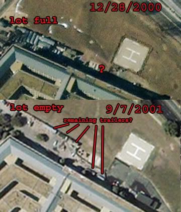
I'm still working out my analysis of the trailers-in-the-impact-zone situation: were they exploded to string airliner-ish confetti across the lawn and helipad as some have speculated? Were they removed entirely before the event as satellite images (see left) suggest is quite possible? Attack witnesses Micheal DiPaula gives a picture of an amptying but not empty construction zone: “we were in the process right prior to September 11 cleaning out the area. We just – we moved all the trailers. Actually, on the tenth we had some other trailers that were just leaving because we were getting ready to turn it back over to the building. And we had one trailer left, which was the – we had the Singleton trailer out there. And – and then we had some other trailers over here. So that’s the lay down area, were the plane actually came over.” So it seems possible there were trailers right there, and gone after, presumably removed by the plane on its way in. Are there any photos of trailers inside the Pentagon? What constitutes a trailer exactly? Why the hell am I still wasting time on things like this? These are the questions I've been tackling for the last three days.

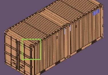
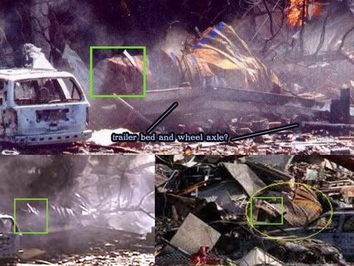
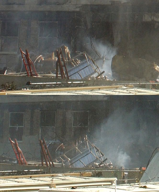
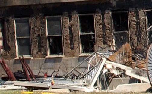
In this case just the graphics and a few notes and links should suffice. Thanks to John Farmer for bringing up this issue again and spurring me with his post The Trailer (redirecting at the moment). Until I read that, I'd been baffled by the melty cheesy form seen in the construction area just north of impact, by the burning SUV (see below), seeing an orange tarp - or something - though others had previously identified this as some type of trailer. More accurately, as Farmer proposed, I'd consider it a steel cargo container, the angle from it being tipped over by the left wing, and the warping mostly due to fire that gave it the rust color. It seems it may have been ON a towable trailer, judging by the floor remaining beneath it and apparent wheel axle. This graphic represents what I feel is the most likely style matching the Pentagon sample, with various matching features highlighted.


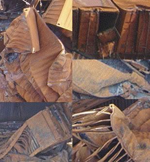
Doesn't look quite right? For comparison, see these sample images of cargo containers subjected to explosion and fire aboard the M/V Hanjin Pennsylvania, which burned for four days off the coast of Yemen in November 2002 after a nasty fireworks mishap. The twisted shapes are those that fell to the bottom of a massive container cell that collapsed. Note the different appearance of corrugated vs. bare-ribbed walls, perhaps different styles of container. The pictures and info were found at this site.

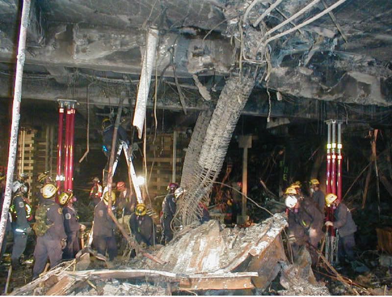
Compare again to this stray scrap photographed from at least two angles, found just inside the Pentagon. It appears to be neither part of the plane nor of the building. In fact it looks kind of like somethinng from the Pennsylvania. Below are the shots these are from, the second (by FEMA's Jocelyn Augustino) I've labeled with the likely column assignations. There are no supports on line 10 in this area, and by looking at the photo index in the ASCE's Performance Report, I've pegged this snake skeleton of a remnant as that of column 9B.
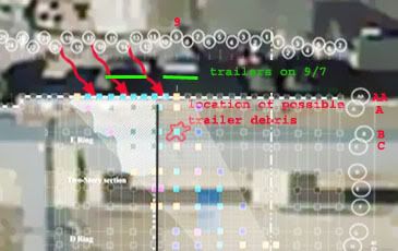
Below is the ASCE's column damage pattern laid over a rendering of the September 7 satellite image (lined up along expansion joints, in black). The trailer location on the right (the plane's left) corresponds roughly with the tipped and melted trailer seen above. The one on the left more closely matches the position to have wound up at column 9B given the 'official' 757 trajectory (red arrows represent approximate angle and impact points of engines and fuselage).

Therefore I speculate that we're dealing with two similar cargo containers in the spots where containers and trailers had previously been seen. One remained outside, the other inside, battered, and invisible in the available photos but for this good-sized scrap (and possibly others if I dug deeper). The intact one shows no sign of exploding to scatter debris, being as it is intact. The other possible container or trailer would have had to undergo a peculiar directed explosion to put it inside the building while leaving no similar traces I've seen in the other direction, away from the building. So while both possible trailers are possibly compatible with a plane strike (no detailed forensics yet), neither seems to make sense from the explosion and fakery hypothesis.
---
Update: Two more pictures of a rather shiny looking warped trailer, near the same construction scaffolding seen in other photos of the trailer.
These are close-up crops of Jason Ingersoll high-res photos provided by CIT. Another from that batch also has background details useful here, from later in the day, after it dried up:

Thursday, March 8, 2007

EYEWITNESS ACCOUNT: MICKEY BELL

Witness: Mickey Bell/Jack Singleton/singleton's Equipment
Last Updated 3/13/07

Creds: Bell was on-site foreman with Singleton Electric Co. Inc., the Wedge One electrical subcontractor. His memory of the attack was unclear when his boss, Jack Singleton, president of said co., explained the event from his own understanding.
Location: construction area, between trailer and building, perhaps fifty feet from impact.
Account (Singleton): "Where the plane came in was really at the construction entrance. The plane's left wing actually came in near the ground and the right wing was tilted up in the air. That right wing went directly over our trailer, so if that wing had not tilted up, it would have hit the trailer. My foreman, Mickey Bell, had just walked out of the trailer and was walking toward the construction entrance."
other reports: "The jet came in from the south and banked left as it entered the building, narrowly missing the Singleton Electric trailer and the on-site foreman, Mickey Bell."
"Bell, who had been less than 100 feet from the initial impact of the plane, was nearly struck by one of the plane´s wings as it sped by him. In shock, he got into his truck, which had been parked in the trailer compound, and sped away. […] The full impact of the closeness of the crash wasn´t realized until coworkers noticed damage to Bell´s work vehicle. He had plastic and rivets from an airplane imbedded in its sheet metal, but Bell had no idea what had happened."

Map 1: Bell's location and vantage point: Rather surpsrining in fact he was able to even breathe after this, let alone drive. This is perhaps due to the vortex effect, the plane's trajectory and cleared space inside drew in the worst of the fires, leaving the inside a burning hell, the outside relativelt calm.

Bell himself apparently remembers nothing, and so his account is, well, nonexistent. Instead what we have here is his boss putting it together in his stead. Singleton wasn't laboring to make a southern flight case, and so made no mention of the smashed generator that was not cleared as the trailer was, its destruction testifying to the right engine passing that way (orange in map above). The right-high banking seen in this impact and the subsequent clearing of the trailer is also consistent with physical damage to the building and with certain other accounts.

App. right engine path: Bell would've been back in there to the right a bit. Smashed generator at far right. Note also the torn fence. If this was faked, I'd love to an explanation of how.

Friday, February 23, 2007

THE CRIME SCENE / OBSTACLE DODGE

THE CRIME SCENE / OBSTACLE DODGE
Adam Larson / Caustic Logic
The Frustrating Fraud
Last updated 8/11/07


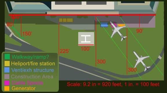
Ever the master of re-inventing the wheel, I’ve assembled an accurate map of the West lawn crossed by Flight77 and some key features that play into the attack. The helipad itself is pretty obvious, but the other features I’ve done in a color code system with a key. Neither the angle of attack nor the linear measurements here are mathematically precise, but generally accurate. The red lines are based on the 920-foot width of the Pentagon’s façade and indicate widths across identifiable spans of the lawn.
Lets look closer at these, from left to right. The unidentified walkway (neon green) with its small structure at the end is not terribly important in the layout or the attack, but is a good foreground reference point for the views from the CCTV security cameras. The post they occupied is just off frame here to the left, their field of view encompassing almost exactly the lawn’s area in near-useless resolution. The green expanse is of course the west lawn itself, the one so widely noted to bear no visible mark of a 757. True enought, the "Pentalawn" itself was untouched in this plane-into-building crash, but there is plenty of evidence of such a missile even in the sparesely-filled space in front of the building.

Next is the heliport (yellow), only about 100 feet from the impact site but essentially untouched. It also housed a mini-fire station with a fire engine. Obviously designed to hanndle helicopter crashes, it seems rather convenient the 757 should hit where the engine could basically spray the fires down without even pulling out. The heliport also served later in the day as the gathering point for the famous fuselage scraps.

Next the blue rectangle represents a ventilation/exhaust structure, obviously just renovated along with the rest of wedge one. This is set into the ground, and surrounded by a low concrete lip, about one foot high. This is the dark outline on the map, which suffered damage to the south wall, the vents inside scraped and mangled, and its east wall, closest to the building, was obliterated. In this photo, we see the gouge in the low south wall, bearing the curve of the bottom edge of an engine on the scale of a 757's. I don’t know the purpose of the light at left usually referred to as a locator light. It’s not far from the helipad I guess. What we have at right is the damage anyone in the know means when they say the plane hit the ground or anything on the ground before striking the building. This is the closest thing to a mark on the unmarked Pentalawn, and indeed a couple feet of turf seems scraped off right here.

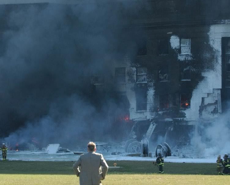
This shot also gives us a good look at the next feature, the cable spools (magenta). There were at least five of these feeding communications cables into the new office space in the renovated wedge. They are at least six feet high when on edge, and some have taken these remaining intact as showing that no part of the plane was lower than that – putting a 757 too high unless it could pass through these, which of course it couldn’t. In fact these are small enough to have been passed over by the gaps between fuselage and engines, or even been rolled aside by the plane’s wake. They are built to roll after all, and probably rolled more during the explosion on impact, and so what we see here is not necessarily the configuration they had WHEN the plane came in. And anyway, they weren’t untouched – note that the one on its side at far left looks slightly deformed, probably by the main fuselage or left wing faring.

Moving on to the other side of the plane’s trajectory, we encounter the fenced-in construction area, shaded lavender. The fence was torn through at that corner by the right engine, as seen below (photoshopped to illustrate the cable spools all evident in the background).
Finally we have the backup generator (orange), parked at the stricken corner of the construction area. It’s the thing on the right above. The giant truck trailer had a front half (generator), and a back half (diesel engine). The issue of having diesel fumes being emitted right by the intake vents is beyond the scope of this site. Anyway, the generator trailer was pushed aside, suffered a burnt spot, a dent in its top, and a massive deformation of its front (generator) half, presumably by the right engine, and possible subsequent melting in the diesel fire. It started out totally rectangular and somehow ended up like this: According to the impact damage and the most astute of eyewitness accounts, the plane was indeed banking starboard high, its left engine basically scraping ground, its right high enough to smack a 12-foot high trailer. It must be noted that the majority of the warping seen here is probably not from the engine itself, but melting from the ensuing fire; it was the diesel fuel in this generator burning that caused most of the smoke at the Pentagon.
---
Not enough evidence? Here are some other quality pages with maps of the scene/details on the obstacles to help you ponder:
- My map is too close to account for the light poles, except the last one. Excellent analysis of these at Eric Bart’s site: LINK
- Desmoulins: The damage before impact LINK
- Pickering/Pentagon Research: Scene map -detailed, includes positions of fire trucks and plane scraps. LINK
- 911 review.com, Jim Hoffman: Error: Obstacles preclude a 757 LINK