Adam Larson / Caustic Logic
The Frustrating Fraud
Last updated 8/11/07
Ever the master of re-inventing the wheel, I’ve assembled an accurate map of the West lawn crossed by Flight77 and some key features that play into the attack. The helipad itself is pretty obvious, but the other features I’ve done in a color code system with a key. Neither the angle of attack nor the linear measurements here are mathematically precise, but generally accurate. The red lines are based on the 920-foot width of the Pentagon’s façade and indicate widths across identifiable spans of the lawn.
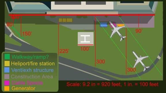
Lets look closer at these, from left to right. The unidentified walkway (neon green) with its small structure at the end is not terribly important in the layout or the attack, but is a good foreground reference point for the views from the CCTV security cameras. The post they occupied is just off frame here to the left, their field of view encompassing almost exactly the lawn’s area in near-useless resolution. The green expanse is of course the west lawn itself, the one so widely noted to bear no visible mark of a 757. True enought, the "Pentalawn" itself was untouched in this plane-into-building crash, but there is plenty of evidence of such a missile even in the sparesely-filled space in front of the building.
 Next is the heliport (yellow), only about 100 feet from the impact site but essentially untouched. It also housed a mini-fire station with a fire engine. Obviously designed to hanndle helicopter crashes, it seems rather convenient the 757 should hit where the engine could basically spray the fires down without even pulling out. The heliport also served later in the day as the gathering point for the famous fuselage scraps.
  Next the blue rectangle represents a ventilation/exhaust structure, obviously just renovated along with the rest of wedge one. This is set into the ground, and surrounded by a low concrete lip, about one foot high. This is the dark outline on the map, which suffered damage to the south wall, the vents inside scraped and mangled, and its east wall, closest to the building, was obliterated. In this photo, we see the gouge in the low south wall, bearing the curve of the bottom edge of an engine on the scale of a 757's. I don’t know the purpose of the light at left usually referred to as a locator light. It’s not far from the helipad I guess. What we have at right is the damage anyone in the know means when they say the plane hit the ground or anything on the ground before striking the building. This is the closest thing to a mark on the unmarked Pentalawn, and indeed a couple feet of turf seems scraped off right here.
 This shot also gives us a good look at the next feature, the cable spools (magenta). There were at least five of these feeding communications cables into the new office space in the renovated wedge. They are at least six feet high when on edge, and some have taken these remaining intact as showing that no part of the plane was lower than that – putting a 757 too high unless it could pass through these, which of course it couldn’t.
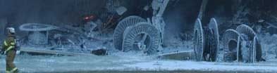 In fact these are small enough to have been passed over by the gaps between fuselage and engines, or even been rolled aside by the plane’s wake. They are built to roll after all, and probably rolled more during the explosion on impact, and so what we see here is not necessarily the configuration they had WHEN the plane came in. And anyway, they weren’t untouched – note that the one on its side at far left looks slightly deformed, probably by the main fuselage or left wing faring.
 Moving on to the other side of the plane’s trajectory, we encounter the fenced-in construction area, shaded lavender. The fence was torn through at that corner by the right engine, as seen below (photoshopped to illustrate the cable spools all evident in the background).

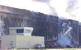
Finally we have the backup generator (orange), parked at the stricken corner of the construction area. It’s the thing on the right above. The giant truck trailer had a front half (generator), and a back half (diesel engine). The issue of having diesel fumes being emitted right by the intake vents is beyond the scope of this site. Anyway, the generator trailer was pushed aside, suffered a burnt spot, a dent in its top, and a massive deformation of its front (generator) half, presumably by the right engine, and possible subsequent melting in the diesel fire. It started out totally rectangular and somehow ended up like this:
 According to the impact damage and the most astute of eyewitness accounts, the plane was indeed banking starboard high, its left engine basically scraping ground, its right high enough to smack a 12-foot high trailer. It must be noted that the majority of the warping seen here is probably not from the engine itself, but melting from the ensuing fire; it was the diesel fuel in this generator burning that caused most of the smoke at the Pentagon.
 ---
Not enough evidence? Here are some other quality pages with maps of the scene/details on the obstacles to help you ponder:
- My map is too close to account for the light poles, except the last one. Excellent analysis of these at Eric Bart’s site: LINK
- Desmoulins: The damage before impact LINK
- Pickering/Pentagon Research: Scene map -detailed, includes positions of fire trucks and plane scraps. LINK
- 911 review.com, Jim Hoffman: Error: Obstacles preclude a 757 LINK


No comments:
Post a Comment