WHY THIS ANTENNA THING IS A NON-ISSUE
Adam Larson / Caustic Logic
The Frustrating Fraud
March 18 2008
last update 3/23 3am
Okay, so here’s my response to Rob Balsamo’s new masterpiece Arlington Topography, Obstacles Make American 77 Final Leg Impossible. Yet again, we hear, some things taken together with other things have again proven the official story of the Pentagon attack is physically impossible. He dated the piece March 13 so he could say dramatically “"Beware The Ides Of March" could not be a more appropriate introduction to this article as it appears the government story regarding the events at the pentagon is officially dead.” Again the merry-go-round spins and in the end… again…. everyone disagrees still. I weary of this game, and this latest seems really a pathetic attempt. But it is in my area and people have asked my opinion, so I guess I need to cover it.
After infinite CIT re-posts of Pilots for Truth misfindings, it seems it was Rob Balsamo’s turn to catch them back. “Thanks to the hard work done by Citizen Investigation Team, they alerted us to review figures regarding topography and obstacles along the flight path of American 77 according to the government story. […] According to the government, American 77 final approach to the pentagon is depicted below.”
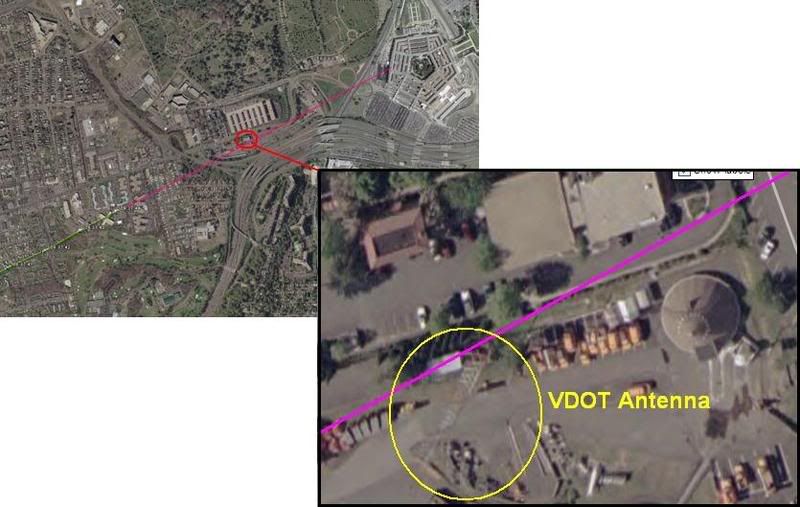
This graphic is not produced by the government, but by Merc Mercy CIT. I’m sure it’s fairly close to accurate, but is it close enough to say where the plane was relative to this 5-foot wide ‘obstacle?’ I’d have to say no. But Balsamo acts as if the government had drawn the line that took the plane right into or over this VDOT transmitter tower, 169 ft tall (including 6-foot antennas on top) above a ground elevation of 135 feet. He never explains whether or not this tower WAS hit, just takes a point right above it as a starting point. From this he did a bunch of math, with too many steps it seems to me, and decided that such a descent from above the tower to the light poles and into the building level would require 11.2 Gs of force.
“Conclusion = Impossible for any transport category aircraft to descend from top of VDOT Antenna to top of pole 1 and pull level to "impact hole" as reported by the government story and seen in the DoD "5 Frames Video". 11.2 G's was never recorded in the FDR. 11.2 G's would rip the aircraft apart.”
I don’t intend to get into the math of all this, but John Farmer’s response is worthy of note: Mission impossible He found that Balsamo’s numbers didn’t add up to what he said they did, double-checked and found the g-force would be 3.5, not 11.2. “So “impossible” is not the word I would use Rob.”
Then he also passed on the video interview of witness Ed Paik explaining how the antenna on top was indeed damaged. Somehow this was not included in Balsamo’s post even though his sources were there when Paik said this. Ranke had to add after that indeed Paik said this but, as Ranke explained back in 2006 “he just deduced this because he saw them working on it the next day. We confirmed with the VDOT employees that the antenna was not clipped.”
 This maintenance was routine then, and just happened to occur one day after the plane flew right over it. Says CIT. Perhaps… But doubts remain; the only photo anyone’s yet found that shows the tower on 9/11 after the strike, by Steve Riskus, shows some hints of a damaged antenna, as Farmer discovered. I can see this, the deformation of the shorter right spire, and it's an intriguing possibility; as Arabesque puts it:
 ""We have a plane that many witnessed flying by the area the previous day. We have the flight data recorder suggesting that the plane might very well have been in line to hit the top of the tower and continue its trajectory; impacting the light poles and the Pentagon. We have a witness who confirms that the plane was flying at the approximate height of this tower and that he suspected that it was damaged from an impact with the plane as it was being repaired the next day--the two meter antenna replaced by a repair-man. If it can be proven that the tower was damaged from the incoming plane, this would be another compelling piece of evidence for the south of CITGO gas station approach and impact into the Pentagon; corroborated by the flight data recorder no less.""[e-mail]
However, this photo is just not clear enough for me. It’s essentially a needle in the distance, lost in a digital haystack. Any slight artifact will warp it too easily. In fact when people were TRYING to take a good picture in 2006, it almost looks like one antenna is missing entirely (below). I don’t think we’ll ever see a picture clear enough to say unless it was taken by the repairman, but I'd need to see better evidence it was NOT damaged before I'd believe that either (a copy of the work order for 9/12 stating the reason for the repair, for example). I’m leaving this aspect ambiguously undecided and moving on.
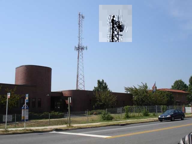
Whether the plane flew just over this spindly 'obstacle' or nicked its top, the descent issues are roughly the same - a descent from 305ft MSL to about 35-40, a total non-linear descent of 270 feet over a span of about 3400 feet. This means a descent of 165 feet from FDR last frame before the antenna and another app. 235 feet dropped from the antenna to the first light pole in the same rough distance but at higher speed. I'm no pilot, but a lower altitude at the tower makes a bit more sense.
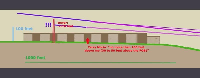
For a different aspect on aircraft height, Terry Morin at the Navy Annex (aka FOB) placed the Boeing “essentially right over the top of me and the outer portion of the FOB (flight path parallel the outer edge of the FOB). Everything was shaking and vibrating, including the ground. I estimate that the aircraft was no more than 100 feet above me (30 to 50 feet above the FOB) in a slight nose down attitude.” For this I’ll us a graphic I used earlier when CIT argued a similar problem relating to descent angles and impossible stuff, just updated a bit. It’s a panoramic graphic so here’s the right half with a reasonable descent angle to the light poles and impact.

And here is the important half, with the tower added to scale and cross-sectional placement. Oddly, my previous lines extended back take it over the tower neatly, but that’s a pretty steep descent. It looks like it would cause 3.5-11.2 Gs, considering the range offered so far. If we take Morin’s account as closer, which I tend to, it had to be much lower, which offers a more reasonable pitch, but takes the plane well below the top of the tower. This means an impact if Merc’s government line is accurate.
But I doubt it is. Flight paths aren't perfectly straight. They wiggle a bit, especially I would think at high speeds in the lower atmosphere. In another post I established that the witness record and physical damage best fits with a moderate left bank over the Navy annex, and likely a slight left curve to the flight path between the Navy Annex and Route 27 where it leveled slightly, with an apparent left bank of about –5-6° evident in the impact damage.
So considering all we know here is a proposal I offer: I had first favored the purple swerve, but after reviewing Morin I'm betting on the green line at the moment, or else the purple one.
- Final trajectory by pole and building damage - ≈ 61°
- Final FDR heading ≈ 59.9° (these are shown in red at the corners).
- The big yellow dot at lower left is the last reported position in the FDR data we have
- The yellow line a straight shot from there to the damage path. This indeed crosses over or within a few feet of the tower, probably too close for comfort if it weren’t high enough.
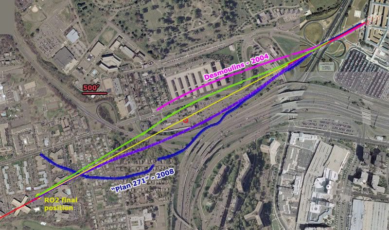
Before going graphically away from straight lines, I added for comparison two non-straight attempts to explain the ‘official’ evidence. In magenta a 2004 estimate by Jean-Pierre Desmoulins with a notable wiggle to it. He’s a pilot. Also in dark blue is an estimate by “Plan 271,” based on eyewitness reports from Dawn Vignola.
The two variations I’ve traced in green and purple are the most moderate explanations. While the green path fits best with Morin's account, the purple one is perhaps more consistent with left bank clues. Note the scale here – 500 feet is just a short line - and that each path is traced along the fuselage centerline. To clear the tower north or south it need only pass 62 feet away (124-foot wingspan). On closer inspection they pass about 250 feet from the tower, so I could’ve made them much milder. In fact I'm thinking the best fit is about 1/3 from the yellow line to the green one, with perhaps a left turn starting earlier, just after the tower, giving it a noticeable left tilt as it approached Route 27.
But even this extreme, both visibly look possible and reasonable – connecting two nearly identical trajectories with a gentle curve away and back, and still safely north or south of the tower. Altitude options open up. Either way, it looks like a reasonable avoidance procedure of a minor object on the attack path. if it were that low, which the witnesses and FDR seem to indicate.
Purple swerve - Max angle required to avoid the tower ≈ 68°
Min angle required to avoid the tower ≈ 53°
Green swerve - about the same
Time frame: app 6-7 seconds from the yellow dot
Any pilots? How impossible is that?
This is a non-issue – a needle of an obstacle that would be missed almost by definition if the path were anything other than perfectly straight, which it probably was. It’s also a non-issue because all previous attempts to ‘prove the official story impossible’ have failed under the test of verification. All that’s happening here is the wrong data being looked at the wrong way and attributed back to reality in a repeated straw man maneuver that’s giving many a case of hay fever. There is nothing impossible about what happened, and as a relative non-issue that seems prohibitively tedious to either prove or debunk I’m not even taking this one to the forums.
Update 3/23:
I took it to the forums a little. 9/11 Blogger (comments page 2) - Above Top Secret.com
update 3/19:
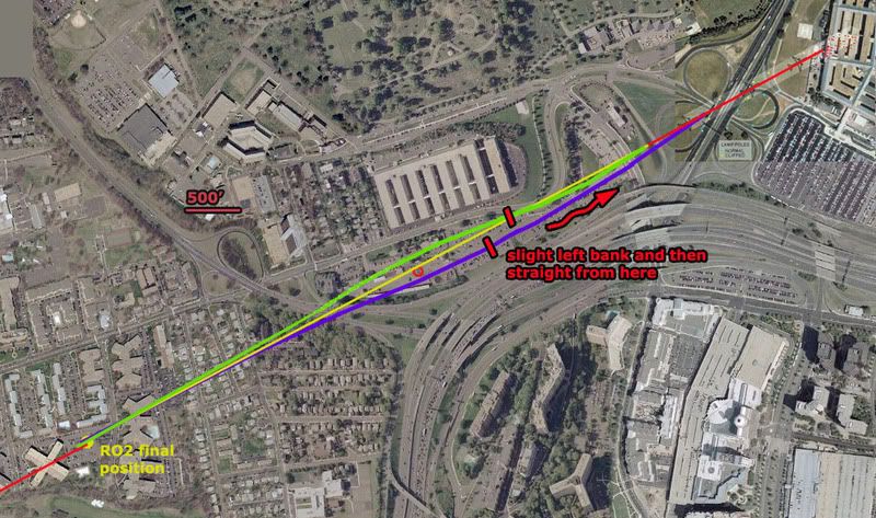
note: in the graphic above I somehow screwed up the 500' scale, making it actually represent about 400 feet. Luckily my margin was still wide enough that these mild swerves are still a fit, both passing well over 100 feet from the antenna tower.
update 3/21:
I just located again Russell Pickering's take on Paik's antenna memories from the old old LCF, 9/10/06:
"I went to the VDOT to confirm it hadn't been hit. It had not. Then in Edward's interview I asked him if he actually saw it hit the tower and he said no. Then I asked him if it hit the solid metal part of the tower and he said no. What he said was that it hit a smaller antenna of 2-3 meters in length on the top. He ended up telling us the reason he thought it had been hit was because he saw somebody up on the tower working the next day.
What had happened then is he incorporated a conclusion from something he saw later into his memory of the original account. The real story is that when the FBI took over the VDOT as a command post they added antennas to the tower for communication." [emph. mine]
So it actually was not a coincidence people were up there the day after a plane flew by there. There was a direct cause and effect relationship between the two, as that plane had turned the area into a major hurking crime scene of the utmost national security importance. They needed many things, including communications. And perhaps the old antenna was also coincidentally damaged by the plane and replaced at the same time. That certainly can't be ruled out and in fact may well be the case judging by the new evidence coming to light. And that would certainly be another problem for the north path fly over story.
Update 3/23: CIT's take was not coincidence of antenna work but rather that it was not damage-related. They seem the feel it was the military, not the FBI, who put up the new antenna. And we have further confirmation that it was not damaged: John Farmer has confirmed the fact again with the VDOT smart center manager. He offered no details beyond "that was not true!," but as Farmer noted "if anyone should know it would be him (he would have to approve the replacement cost since he was the manager)." [e-mail]


No comments:
Post a Comment