Showing posts with label east-of-the-potomac claim. Show all posts

Tuesday, July 15, 2008

FLYOVER LINK DOESN’T LINK

FLYOVER LINK DOESN’T LINK
Adam Larson / Caustic Logic
The Frustrating Fraud
July 15 2008


Digging through John Farmer’s north-path flyover paper You All Just Haven’t Talked About it, I had to respond to this one point and draw attention to a little-known but verifiable witness that could confirm or deny it.

“Mark Gaffney and Pinnacle have already documented a plane that approached the White House from the Washington Monument area and was photographed by Linda Brookhart as it turned over the White House towards the Capitol Building.”

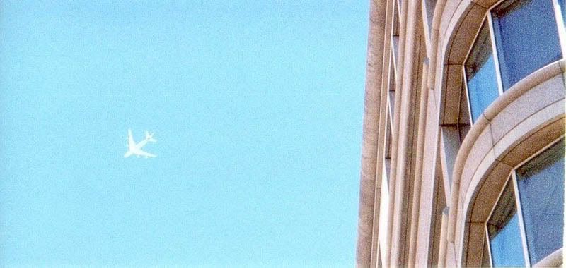
Before continuing, I should note that although we’re on bad terms at the moment, Farmer did send me Pinnacle’s documents to review, and I will. I’m still waiting for Gaffney’s book (is it out yet or what? I pre-ordered it months ago!) And for reference, this is the plane in question as snapped by Brookhart - refer to this picture when reading Farmer’s attempt to ambiguously blend this craft with the one seen by Lagasse, Brooks, and “NEIT428:”
“Further, Peter Jennings reported a plane over the White House at 09:41, 2 1⁄2 minutes after the Pentagon event official time of 09:38. So is the plane witnessed by the Citgo and ANC witnesses the same plane? Without more definitive evidence regarding the direction the plane left the area, it is difficult to say.”

The white four-engine plane over the capitol could not have been the same silver 2-engine AA airliner seen on the north flyover path. Further, the direction the plane left the area according to the Citgo witnesses was none. So no, it can't be the same plane. It's not "difficult to say" from my end, but I understand how others might have a harder time deciding.

For now I want to focus on a link in this path Farmer did not cite: Lt. Col. Stuart Artman. A local Florida paper described him on 9/15/01 as a 44-year old "licensed commercial airline pilot of the Army Reserve and engineer in Winter Haven, Florida” and gives his location at the time as “walking near the Washington Monument when he saw a plane fly low over the city." The only direct quote was "I saw the plane that hit the Pentagon. It went behind some trees." The paper followed with “then he saw the smoke.” [source]

It went behind trees, he saw smoke, he feels it hit the Pentagon. Deduced, of course. Here is a graphic highlighting the Monument area, which he was at or near, so exact PoV is unknown. There are several bands of trees he could mean, most likely on his side of the River. A CIT-type north path flover is in yellow, continuing towards the monument area, and the official path ending at the Pentagon is in purple.
Did it fly all the way to his rough location without re-emerging from behind the trees? Was he right under a really dense tree so he didn’t even see it overhead? Because he did not say the plane also flew over the Pentagon after the impact. He did not report any plane heading through the plume right towards him and on to the Capitol. If he had seen this, would he have called that “the plane that hit the Pentagon?” The paper did say “low over the city,” but this means nothing. It’s possible the reporter just doesn’t know the layout or didn’t ask specific enough questions to know if it was over DC or over Arlington.

Perhaps these weaknesses led Farmer to not include Artman in his short five-witness lineup for his paper, but CIT saw it differently, citing this brief account in The Pentagon flyover video, in their list of six additional witness accounts in support of the decoy plane looping over the Capitol either before or after it "hit the Pentagon." Aldo Marquis CIT also cites Artman’s account in his C-130 flight path essay in support of the contention:

“It is clear from a number reports that the plane flew over DC or the Capitol, so we really can't accept that it "had not crossed over towards the White House or towards the Capitol", as Mineta tries to assert.”

Who could believe Bush’s man Mineta over “a number of reports?” Never mind that it’s not just him, but also the radar, the black box, all the physical evidence, the roster of witnesses describing a path ending at the Pentagon, and the total lack of witnesses to any flyover, including the supremely well-placed Lt. Col. Artman that indicate the plane was perhaps headed towards the monuments and the mall but never got that far, having been traumatically absorbed by the Pentagon short of crossing the river.

Can Mr. Artman be contacted by CIT or Farmer, Gaffney, Pinnacle, or any other flyover proponent to get some details on this flight roughly over his head that was omitted from the scrap of his account we have? This is very Important I should think. Perhaps he was being censored in ’01 and maybe he’s been “gotten to” since, but it should not be left unexplored. He does seem to appear in people searches, all you guys, and all the clues you need are in this very post. I would perhaps offer to try myself, but I have no questions for the man and the onus is on those trying to prove some stupid hobbled-together "deception." Best of luck.

Monday, May 12, 2008

SIX MILES SOUTHEAST

SIX MILES SOUTHEAST
Adam Larson / Caustic Logic
The Frustrating Fraud
May 12 2008
last update 5/14 12am


Citizen Investigation Team (CIT) now promote four primary claims regarding the decoy aircraft that everybody thought hit the Pentagon; First and foremost is their original North of the Citgo (NoC) claim, which necessitates the pivotal but otherwise unproven OtP (Over the Pentagon) claim (my own acronym, the others are theirs). This is also supported by the Over-the-Navy Annex claim (ONA) explicitly offered by Paik with supports recently wrangled from other witness accounts. And then there’s the tangential but important East of the Potomac (EoP) aspect, which is at issue in this article. As CIT co-founder Craig Ranke recently said “In addition to proving that the plane was on the north side of the former citgo gas station we can now also prove that it came from east of the Potomac River and actually flew over DC skies! This is absolutely fatal to the official flight path that never has the plane over DC skies at all.” [source]

I haven't tried so far to systematically debunk the EoP claim, perhaps out of fear that it would prove correct. When I finally decided to face my possible fear and finally tackle this case but found I cannot disprove it. It’s a strong enough case I don’t even feel like trying very hard, except on the one point I already did so with. I will have a fuller explanation of my general failure regarding EoP later, for now here is that one evidentiary support that I've looked at closely.

Ironically, this proof of the plane being over the river from where radar shows it is from - people whose job it was to watch where the radar was showing the plane. If CIT's reading here is correct, it would again prove the later-released radar data fraudulent, so it's a big deal. They cite the NORAD tapes, and a 09:35:41 call from Colin Scoggins at FAA’s Boston Center to Northeast Air Defense Sector (NEADS) base “Huntress.” [transcribed from audio]

Boston (Scoggins): “Latest report, aircraft [inaudible] six miles southeast of the White House.”
Huntress: “Six miles southeast of the White House?”
Boston: “Yup. [to someone else] East? He's moving away?”
Huntress: “Southeast from the White House.”
Boston: “Aircraft is moving away.”
Huntress: “Moving away from the White House?”
Boston: “Yeah.…”
[…questions on ID…]
Boston: “If you wanna hold on a second, [inaudible] people down there looking.”
[Long pause – to someone else] “Where was that position?” [backround on Boston end, inaudible with emphasis on last syllable rhyming with yes.]
Boston: “Six.. six southwest, six southwest of the White House and deviating away.” [emph in original]
Huntress: “Deviating away. You don't have a type aircraft, you don't know who he is…”
Boston: “Nothing, nothing. We're over here in Boston so I have no clue. That—hopefully somebody in Washington would have better—information for you.”


The direction of the original deviation isn’t clear other than ‘away’ from the capitol, but CIT is quite confident in placing the plane southeast of there and moving west, eventually crossing the river due south of the capitol, and continuing to six miles away on the other side in time for the update 35 seconds later of it being SW (it was either flying very fast or the second report was much fresher than the first). An alternate guess is it was never east of the river, and the change from southeast to southwest was a correction of the same last reported position.

I could just stop there by offering that guess, but when I tried to earlier, Ranke rebuffed it by stating of the above dialog “that wasn't an accident. He even confirmed it and THEN came back with an update of it being SW which makes perfect sense.” [source] I cannot prove that this is a wrong interpretation; perhaps Colin really was watching the real, pre-alteration radar data when it symmetrically traversed the river. And supporting this possibility is the fact that, as Ranke points out, “Scoggins wasn't the only ATC to report a plane east of the river either.” Oh no, his claim is supported by Major Kevin Nasypany, NEADS mission-crew commander, also from the NORAD tapes:

09:36:23
Nasypany: ‘I got a aircraft six miles east of the White House! Get your fighters there as soon as possible!”
Unidentified: “That came from Boston?”
[…]
Nasypany: “‘We've got an aircraft deviating eight miles east of the White House right now.”


Notice that this report follows Scoggins’ by only 40 seconds and someone feels it may have been based on that info from Boston. Is it possible he’s just repeating the report cited above rather than independently confirming it? Is "eight miles” an anticipated distance, an error, or real info? Does east mean southeast, or had it moved north? Most interestingly, if we take this as independent confirmation, it shows that that plane was not only east of the Potomac, but also deviating further EoP, rather than towards the river to cross west as CIT feels happened next.

Perhaps it’s all a complex cover-up where they altered some parts of the record to hide the real plane while other parts are let through, to provide cover for something, or something. I can’t rule this out as a possibility, but my tentative alternate guess – for whatever it’s worth – is that the report Scoggins received had one error - southwest was reported as southeast, and both Scoggins and Nasypany just echoed this error. A bit of confusion is evident in what Nasypany said later to Vanity Fair’s Micheal Bronner: "Six miles south, or west, or east of the White House is—it's seconds [...] Airliners traveling at 400-plus knots, it's nothing. It's seconds away from that location." That is, they weren’t worried at the moment about which direction the hostile craft would have to fly for a few seconds to hit the White House – they were worried about how few seconds that was, and how to get fighters to that small area fast. They did sort out the error, if that's what it was, but the fighters didn't get there 'til far too late.  

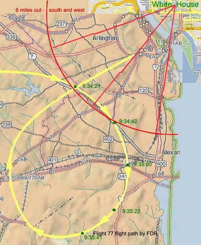
Anyway, you can test this east-west error reading here: refer to this graphic of the radar flight path, marked roughly with lat-long cross-points from the FDR (corrected and approximate), and a 6-mile arc south and west from the White House. Then read the reports below, corrected. update: As explained in the comments below, 6 miles meant nautiical miles which - I think - is about 7 land miles. So note this - the red arc is set a bit too small.

Scoggins 9:35:41: “Latest report, aircraft [inaudible] six miles southwest of the White House.”
“Yup. West—he's moving away? Aircraft is moving away.”
“Six.. six southwest of the White House and deviating away.”
Nasypany 9:36:23: "I got a aircraft six miles [south]west of the White House! […]
We've got an aircraft deviating eight miles [south]west of the White House right now.”


One word, one dyslexic slip in the information chain, is all it takes to turn this into a brilliant indication that the above path is the one seen by radar controllers on 9/11. On the other hand, a different reading could, with a few complications, be found to support the EoP claim, which, again, I still cannot disprove.
---
Update: SPreston has used this "six miles southeast" evidence to say the FDR path is PROVEN a lie.:
"PROVEN: This Flight Path Crossed Over the Potomac, Over DC, and Six Miles Southeast of the White House [...] How come all the witnesses actually interviewed place the actual aircraft east of the Potomac and over Washington DC and 6 miles southeast of the White House and banking around Reagan National? "
None of the witnesses says this that I've seen. One has it looping around from the east (Chaconas and he alone) and this location and distance is not from any interviewed witness, but from the above-described possible error. Almost all other witnesses were west of the Potomac (a few just east as well but looking west). SP, help me out if I'm missing something! Comments open...