Adam Larson / Caustic Logic
The Frustrating Fraud
June 19 2008
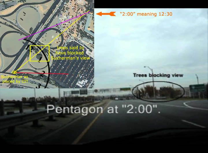
“Bobloblaw,” the anonymous but effective debunker of Citizen Investigation Team claims, has scored some solid hits against CIT lately, contacting their witnesses, accepted and suspect, to set the record straight as much as possible. So far he’s keeping it all off-the-record, and I can’t vouch for what’s really going on, but I tend to believe him that one of those contacted is USA Today editor Joel Sucherman (suspect, highly), who contests CIT’s placement of him, which I already found was grossly dishonest.
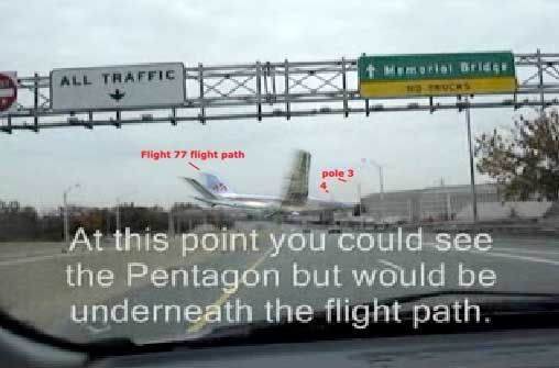
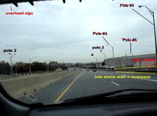
However, I had bought their location he could not be at as it was “underneath the flight path” and thus offered no side view of the plane to fit his account of seeing its AA stripes. Sure enough, the spot they filmed on their 2006 drive up Route 27 and included in their USA Today Parade video is right next to light poles they labeled #2 and #3, the originals of which were struck down by the plane’s wings on that day. Bobloblaw however looked closer at this light pole labeling (also viewable as stills here) and found it wrong. He challenged Craig Ranke CIT, in a thread at their forum named after me, and eventually got Ranke to admit to being wrong on pole #1 and, therefore, the others.
I had not caught this myself, or analyzed their pole labeling, but saw it as soon as Bobloblaw mentioned it. And there’s little excuse for it escaping these Citizen researchers (both of them) even as they used the wrong poles to make absolutist arguments to disprove a witness account they don’t like. Spurred by Bobloblaw’s challenge, ranke took his case to the experts at the Loose Change Forum: “Light pole/camera mast perpective question; which is in front?” Even his sympathetic friends felt it necessary to acknowledge the obvious; Look-Up said “the pole must be closer to the observer than the VDOT mast,” while SPreston and 22205 concurred and tried to spin it all back on “Bob” as a blown-up non-issue. Ranke relented at this point: “It appears to be behind the VDOT mast in those images but it is not. That threw me off. It's a perspective issue but the error is mine.”

While it may appear, in stills at least, that this pole is behind the VDOT camera mast, it is clearly before (south of) the overhead sign structure, while pole #1, the first taken down by the right wing, would be on the other side (north) of it. This graphic illustrates the concept, with multiple pole positions down Route 27 highlighted and traced across to their counterpart across the road. The pole placement could have been easily verified against satellite photos, site photos by others, and whatever else. These all indicate the arrangement on the left is light pole, VDOT mast, overhead sign, pole 1, pole 2, then an ordinary pole. If this were pole 1, they’d have to wonder what happened to the last pole before the overhead, or why pole #1 looked so big. Apparently they didn’t, officially anyway.
It always looked to me too the light pole was behind, the way the mast seems to totally cover it and also its truss arm as they are passed and separate. This made me even wonder if they re-painted the mast in to make it seem in front, but in fact the poles would merge and the arm would not really show against, so it appears most likely an innocent illusion. It should be noted this is an optical effect, not a perspective problem, as the perspective shift is clear in CIT’s own video and sequential images from it. When you see it, it gets trippy for a second, then you adjust and say ‘oh, okay. That makes more sense.’ This is how some of us learn.
I’m unable to view the CIT forum (they’ve blocked me for some reason), but Bobloblaw collected some Ranke quotes from the debate he and fellow critic “Stinky Puh” engaged Ranke in. After getting second and third opinions, he did cede the point, as these compiled quotes show:
Ok ok.
I admit it now.
I went over the video again.
I concede I mislabeled the poles.
I publicly apologize to bob and stinkey.
Well, that might seem quite gracious of him, until you read the list Bobloblaw passes on of Ranke’s words up to that point, where for ten pages he denied the conclusion I and everyone else reached instantly once spurred to look at it.
Please stop wasting my time with this nonsense.
You and Stinkey are ridiculously wrong.
Everyone knows this.
... because I am right and you are wrong.
Pole one is BEHIND the vdot mast in every image liar.
So either admit you are a liar or a stubborn fool because you are WRONG.
I am not wrong.
Your stubbornness with this demonstrates how you are willing to say ANYTHING to cast doubt
This is fact and you are wrong.
Seriously man.
If you can't concede this you will have to go.
You are wrong.
You will concede or leave.
Do you get it yet?
Ok then you are banned.
You can come back when you admit it.
You have to admit you are wrong.
It's because you know you are wrong.
Pathetic.
So either admit you are a liar or a stubborn fool because you are WRONG.
You better do SOMETHING productive because so far you are batting zero.
You have proven yourself manipulative and deceptive.
You will be banned.
Why did it disappear?
Did aliens take it as I drove down the road?
No.
It's nothing but a perspective issue.
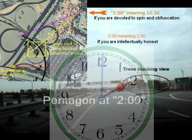
Wow. Yeah, see, Ranke’s got this perspective where he’s determined to prove Sucherman a liar. And this is where we get into the relevance of this ‘error’ Ranke’s owned up to like the big man he is. This mislabeling shifts the flight path on the left one pole placement - about 110 feet - to the south. On its face, this is significant but not the biggest deal in the word. As he said
“No harm no foul as my original point doesn't really change anyway. I'm only off by a pole.”
Nope. In addition to this ‘non-foul,’ that makes him ‘only” off by 100 feet-plus on the left-hand side, he also ignored perspective and verification on the right, placing his “pole #3” as the first one visible after the overhead sign, right across the street from his pole #2 (actually #1). This puts his pole placement TWO spots off on the right, for a difference of app. 250 feet by my measurements. This is a second egregious mistake he might have avoided if he even tried, and implies a flight path nearly straight across the road, whereas the real pole-testified path slants more up the road as well as across (purple below).
 [More graphics and some juicy comments available here]
 Looking at this graphic and keeping in mind that he was on the right half of the road headed north, the implications are clear. The issue at hand is whether he could be past the trees and thus have a clear view of impact as he said, while still being far enough south of the plane to see its side. So this fortunate labeling error, read back as evidence, wound up shifting the path feet about 200 feet south, shrinking the area to put Sucherman in accordingly and squeezing him back behind the trees to make him a big fat liar when he said “no trees.” Fact is, however, under the overhead sign = past the trees + could well see the plane and its stripes just fine. From the vantage below, the impact zone itself is still barely obscured by some branches at the far right. The plane I slapped in is at about the right scale, and the approximate right angle and shows just why these “investigators” might have wanted to pull it all south a ways. Oops, they did. If only this were the first time…
 As Ranke is quick to point out, all of this does not change the 2:00 and passenger window claims that, as I had previously pointed out, corroborate each other and, read literally, make him a north-path witness. While both are likely just memory errors, it is uncanny how they happen to support the same thing CIT was looking for but missed. All this revalation has spurred Ranke to alter course on Sucherman and claim "I guess you're right Larson. He HAS to be a north side flyover witness! LOL!” What the hell is he LOLing about? They squandered this gift already and are still dealing with the fallout from the distortions necessary to do so.