Showing posts with label Flight path. Show all posts

Sunday, September 21, 2008

PILOTS FOR 2+2=5

September 21 2008
possible updates


For what it's worth, Pilots For 9/11 Truth recently released a new video based on math and stupid, that tries to say some stuff about the Pentagon attack. They're hoping to sell it, and so maybe have a breakthrough to push it with, like finally deciding on a theory of what did happen rather than just raising leading questions pointing towards no plane hit, held back out of "professional caution" and responsibility. LMAO. Please do not buy it, unless you support their long-running practical joke on gullible suckers. I don't even plan to watch it, but their talking points about the video focus on the presence of some serious math to correct their earlier egregious errors, months in the process of correcting. I'm fully capable of understanding the formulas I either failed to learn or forgot after High School, but only with the kind of time and attention I won't devote to facts whose only purpose is to debunk stupid shit I already know is wrong. Therefore, for those inclined to follow the math, especially those who lean towards believing the video, here is a link to John farmer's posts breaking down the "errors."

PFT Fantasy Flight Path and further analysis.

Myself, I don't feel like wasting any time on this. But if I change my mind, I'll plunk more stuff into this link. This is quite sparse, so I'm sure I'll have to add something.
---
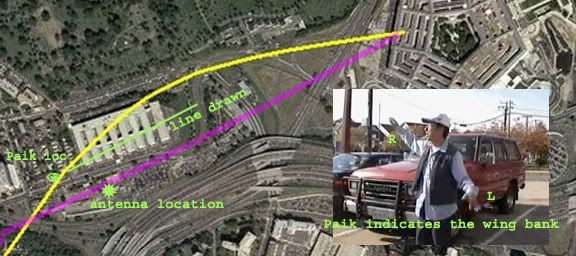
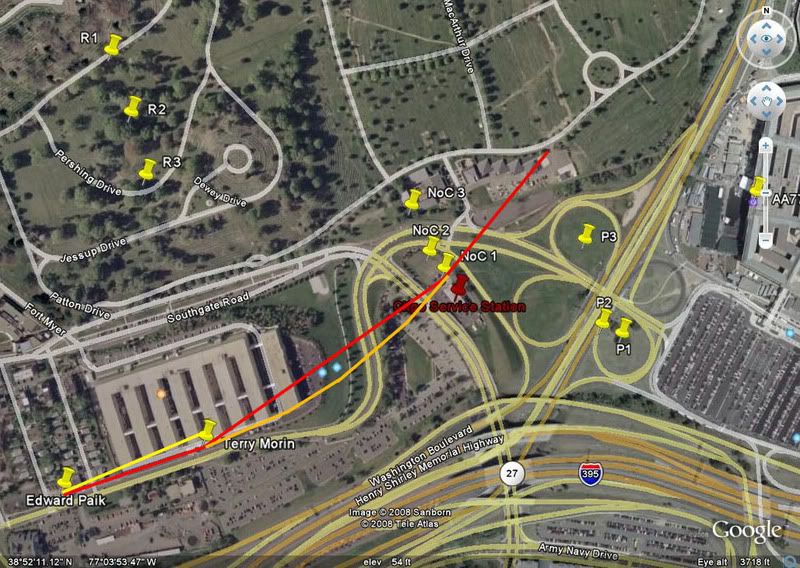
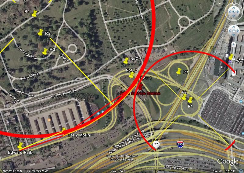
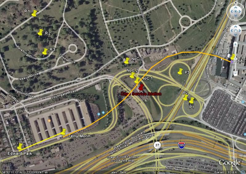
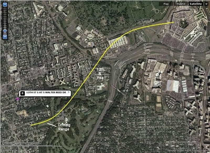
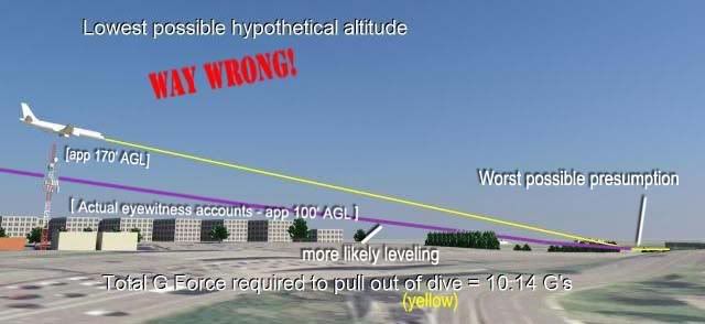
Their G-Force on final descent analysis was relesed for viewing in a promo short video. Essentially, it’s a response to their epic 11.2 G error (admitted even!), first proposed in the Arlington Topography piece earlier this year. The correction was several months in the making, and only slightly different - 10.14G in the best case scenario. Now 11.2 Gs was waaaay off from what everyone more reasonable found, and it would appear the reason for the still-large gap is that peoples’ presumptions differed. His descent path is shown here in yellow, my notes added.
They presume, as I knew, a descent from just above the antenna tower to low enough to strike the first light pole by the time it got there. Two problems – it did indeed have to end where they show, but not start. The antenna tower is maybe 5 feet wide, and there’s no evidence if it was directly over, to the left, or to the right of it. All we know is close, and judging by eyewitness accounts, it was considerably lower than the top, so either left or right (and I’m banking on left, or north).
Terry Morin: “I estimate that the aircraft was no more than 100 feet above me (30 to 50 feet above the FOB) in a slight nose down attitude.”
Edward Paik: "It almost hit my roof [...] If [the plane was a] little bit lower… it would have hit the [Navy Annex] building almost it seemed like. [The wing] knocked down the antenna… the plane was in the middle of the road… that’s why it hit the Antenna."

There is some evidence the antenna may well have been damaged, but it's not conclusive. If true, this would leave PffT's initial altitude presumption nearly correct, and contradicts the lowness described by both Morin and Paik. What correlates is a plane tens of feet above the Annex roof, I'd say closer to 30-50 feet above rather than 90-110 above as PfffT decide is the "lowest possible." It would be laterally quite near the tower, near enough to seem to have impacted it near the top. This would put it over Columbia Pike, and and running near-parallel the building's edge. Numerous witnesses (including Paik via gestures and Morin via seeing stripes on one side) confirm the plane was in a mild left bank, with right wing high. If the plane passed north of the tower, the right wingtip would be nearest the tower and its antenna at the top.

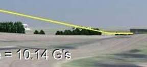
So, the descent from altitude, at the very least, cannot resonably be presumed as directly above the tower, greatly effecting the steepness of the resultant dive to the light poles. Second, and more important, the nature of the dive change is at issue – he has a sudden pivot, two straight lines bumping into each other, rather than like an actual plane's single uninterrupted parabolic curving movements. Ooops! My first comment was that this descent “has been sponsored by the letter L,” ala Sesame Street, and Reheat and other JREFers aptly took to calling it the ‘hockey stick’ descent. [Horatius did a funny comic strip on it] Apply sharp corners to “alleged” flight paths and you’ll force all change to one point and get unrealistic G-force calculations. Thanks PfffT for illustrating bad reasoning at work. Now just up the volume on the certainty language and demands for phone debates, and you can perhaps at least provoke people into wasting time, as a consolation prize for not being accurate.

Discussion on the G-Force video:
Pilots For 911 Truth
JREF
Above Top Secret
CIT forum

Friday, August 29, 2008

THE LAST WORD ON THE "FLYOVER WITNESS"

THE LAST WORD ON THE "FLYOVER WITNESS"
Adam Larson / Caustic Logic
The Frustrating Fraud
First posted August 28 2008
Video added September 4


Online Videos by Veoh.com

So a while back I posted about a packet I had sent to CIT's alleged Pentagon “flyover witness” Roosevelt Roberts. It was returned to me unclaimed, either declined or sent to the wrong address. I had a second place to try him, and at least half-meant to. My general MO however is to not to bother the witnesses over idiotic miscontructions of the Comedy Improv Team or others, and even though I wanted clarification, I had been dawdling on trying again to contact him. Recent developments have shown me there is really no need to break my pattern. Everything was already explained well enough for my liking.

CIT had first aired an edited collage of his interview on Air America back in May, touted as the much-awaited lone witness to the flyover decoy plane immediately after the “impact” explosion. Finally SOMEONE immune to the unexplained optic trickery that fooled everyone else! There were some questions raised, and the team had been holding back their full interview, which is why I set out to contact Roberts. However, CIT recently released it at their discussion forum, apparently full and uncut, and I can see why they were sitting on it. I was first alerted to this by CIT critic “Biscuit Cough,” who transcribed it and offered some analysis at their forum and at Above Top Secret on the 18th. [Excellent work, mate!]

The audio file was posted as a subset of a separate issue: “C130 Arrived On Scene Nearly 3 Minutes After Event, Definitely not the plane Roosevelt saw.” Aldo Marquis preceded the link with a preamble to set the tone, which I’ve copied below with my corrections bracketed in red.

Pentagon officer Roosevelt Roberts Jr was at the loading docks and experienced the explosion [on TV, of Flight 175 at the WTC] (which he [Aldo] thought was [supposed to be] the impact [of 77 at the Pentagon]) inside. He details lights flickering and pieces of ceiling falling [lights unclear, ceiling problems only AFTER he saw the plane, below]. He then takes about "7 steps" out to the edge of the east end of the loading dock in South Parking lot and sees a "silver commercial aircraft liner w/jet engines (not propellors)" [over the lane one area, so west of him] traveling from the 27 side or from [actually TO] "where the 'first plane' hit" traveling east towards DC [and then departing the opposite direction, “southwest coming out”]. He said it was very low, he estimated 50 ft to less than 100 ft over the South Parking lot [lane one] area, he said it was banking and coming around to the mall entrance side [after being led to start making shit up]. Most importantly he described it like a 'pilot who missed the landing zone target and was coming back around' [and flying away to the southwest, which no one else reports]. Roosevelt saw the flyover plane [no, he saw Flight 77 on the approach and just didn’t describe the impact].

This interview for me represents the final word on Roberts, and it’s his own. Here's my attempt at drawing a light path. How did CIT have a hard time interpreting these words into a path? The loop here is perhaps tighter than he meant. Will have to be checked against other evidence to gauge its likely scale. I don't want to be accused of tightening it to make this breakthrough account seems less likely than it really is. This confirms their flyover findings perfectly, right?


ETA: Some words after the last word.

Tuesday, August 12, 2008

THE SOUTH PATH IMPACT: DOCUMENTED

THE SOUTH PATH IMPACT: DOCUMENTED
Adam Larson / Caustic Logic
The Frustrating Fraud
first posted August 12 2008
last update 10/11


NOTE: The full post isn’t done – I’ll be adding some details and graphics for a couple days. I've opted to simplify the process by not citing and linking to all my sources. Dig around if you have any doubts. Props to Mangoose at JREF for a couple of these leads.

“We Tried…”
Citizen Investigation Team (CIT) brags of their growing list of explicit eyewitnesses to a North-of-Citgo (NoC) flight path that rules out their decoy plane hitting the Pentagon or anything on the ground, no matter what any of the same witnesses themselves say to the contrary. I believe they’re claiming 13 such witnesses at the moment, as featured in their latest full-length mockumentary, and sure to grow judging to their rhetoric. Corroborated 13 times! That’s fatal to the “official story”, which has the plane passing south of the Citgo station along the path of physical destruction before and into the Pentagon and ending there. CIT frequently boast how “all the witnesses” place the plane north of the Citgo, as clearly as they saw it crash into the building anyway, and NONE of them saw the plane on the south path.

The claim was repeated, for example, in our first phone ‘debate’ in November 2007 [40:00–42:00 or so], in their new video [link above, 3:20 in] and recently at the Loose Change Forum, when Aidan Monaghan was probing CIT’s Aldo Marquis. "Are there any south-of-Citgo witnesses?" he asked. Marquis responded simply “That is a negative,” and re-posted the one-liner ten minutes later for emphasis. And it’s not that they haven’t looked; they tried hard to debunk their own findings, but as their main site explains:

“We tried to find someone who might have seen it on the south side but it just wasn't happening.
[…]
We sure haven't been able to find ANYONE who is willing to directly contradict the north side claim AND we have not found a single previously published account that directly contradicts it either.”


How odd. I didn’t really have to even try to find previously published south path accounts, although a startling number have been pre-dismissed by CIT as among the suspect. I will offer my services free of charge. I found 13 worth making graphics for, though I’m sure there are some others. In fact, it could be said that all witnesses who saw the plane at all, whatever they may say later, saw it on the south path.

The Scene and the Spectators
The “official path” (violet in the graphics below) runs roughly along I-395 at its bend, but nearer parallel with Columbia Pike and the edge of the Navy Annex it flanks (the big harmonica building). The path had to be nearly straight but with a slight left curve and accompanying mild wing bank - left low, right high. After the Annex (entirely south), it passed south of the Citgo station (the smallish structure after), descending as it crossed Route 27, striking lamp poles, skimming the lawn, and entering the building low. The north path is also shown below for comparison, in yellow. This is CIT’s most-widely promoted possibility, never meant to be THE path, and shown to be aeronautically improbable (as have their others, to differing degrees). This angles across the Annex s-n, banking hard right along the way (left high), passing to the north of the Citgo almost at Arlington National Cemetery, descending a bit, then pulling up to fly over, yet somehow appearing to still impact low into the building.
The reason their case has some traction is the same reason that even 13 accounts can’t override the overwhelming case for the real event - eyewitnesses are the weakest type of evidence. Memory is notoriously prone to various errors and psychic distortions. Their memories are usually vague on trivial details like which side of a gas station the plane passed by, easy to be confused, misread, and maybe deliberately dishonest, especially when pushed on points like the above. There are however exceptions that freely and clearly delineate the “official path.” Now just as the whole point of NoC is that it means no impact, the unanimous impact reports could be taken as evidence the plane was on the path consistent with the damage caused. I could also use altitude clues to rule out a pull-up above the light poles, ruling out all but the “official path.” Either would make my job entirely too easy, so here I will only cite specific South of the Citgo (SoC) clues as they sporadically pop up. This is a short list and there are plenty of others that offer decent clues pointing directly at a south path, but these here are13 of the strongest that each confirm it in multiple ways.

1) Albert Hemphill
At the Navy Annex, “peering out of the window looking at the Pentagon.... the large silver cylinder of an aircraft appeared in my window, coming over my right shoulder as I faced the Westside of the Pentagon directly towards the heliport. The aircraft, looking to be either a 757 or Airbus, seemed to come directly over the annex, as if it had been following Columbia Pike.” He also gives the wing bank (remember, north path means left high) “He was slightly left wing down as he appeared in my line of sight […] As he crossed Route 110 he appeared to level his wings […] as he impacted low on the Westside of the building
2) Terry Morin
Another witness at the Annex (“FOB” in account). From his stated vantage point, Morin could only see the plane for the length and detail he describes if it were on the south path. CIT and Pilots for Truth have cited problems with the line of sight blocking final moment and this is valid – and doubly so for a plane passing entirely north of that line. "Teri" Morin has changed his once-vilified story and this one has gotten very weird, to hear the dispatches from CIT-land. I don’t believe them. This is what we know Terry Morin said right after the event:

“I started to hear an increasingly loud rumbling […] One to two seconds later the airliner came into my field of view. […] The aircraft was essentially right over the top of me and the outer portion of the FOB (flight path parallel the outer edge of the FOB). […] The plane had a silver body with red and blue stripes down the fuselage […] Within seconds the plane cleared the 8th Wing of BMDO and was heading directly towards the Pentagon. […] As the aircraft flew ever lower I started to lose sight of the actual airframe as a row of trees to the Northeast of the FOB blocked my view. I could now only see the tail of the aircraft.”

Trees to the northeast of the building is the only thing that doesn’t fit – he must mean northeast of where the plane had passed the Annex. These run along the Pike as it bends, at the crest of the hill looking down over the Pentagon (at the "n" in "line of sight"). Seeing stripes is consistent with it being a tad south of him and banked left.

3) Madelyn Zakhem
A VDOT employee previously published as a witness, Zakhem was verified by the LTW/CIT/Pickering entourage in August 2006. Aldo Marquis was not impressed and noted soon after participating “her account placed the plane "inches" from the roof of this small building [she was at]. With the left tilted down. Unfortunately, this would place it BELOW treetop level which we all know is impossible.” A figure of speech read too literally and debunked is a straw man tactic of course, and a convenient one, as the building that plane was (some number of) inches directly above, clearly puts it on the south path, and with the official bank to the left. Marquis later expanded at Above Top Secret : "Trees blocking her view. Madlene is a suspect witness. She is clearly lying about the flight path. We know because Edward blew it out of the water and we interviewed her, and now her bizarre behavior is explained.” [For Edward Paik, see below]. They can’t find any south path witnesses who’ll go on record, but the reason for strenuously denouncing this witness specifically IS that she’s a south path liar on record with THEM. So Aldo pulls the old Crypyo-Jew move: “Madlene Zackem, the lady with the jewish last name, Israeli accent while displaying a crucifix around her neck is not telling the truth about what she saw."

4) Edward Paik
The guy who blows "Madlene"'s account "out of the water" is not really a strong case for a south path in that his testimony and flight path drawn for CIT in late 2006 directly contradicts it - three versions running across the Navy Annex and thus pointing either OTC (Over-the-Citgo) or slightly NoC. However, his account is jumbled and has south path clues mixed in. When he first talked to the CIT guys and Russell Pickering earlier, he had said he thought the plane clipped an antenna tower just south of Columbia Pike: the wing "knocked down the antenna… the plane was in the middle of the road… that’s why it hit the Antenna." It didn’t really do this, (or did it?) but for him to think so, it would have to be close to it, which it almost certainly was. Also even as he draws a path entirely north of the Pike, his instinctive gestures belie ambiguity, pointing almost straight down the road, and indicating a left bank, which directly contradicts the massive right bank needed to go ONA and NoC. I believe he’s a south path witness and for whatever reason his account came out sort of supporting the north path (really it’s right between the two). How odd that the guy who proves suspicious crypto-Jew Zakhem a liar matches her account more than it differs!
5) Keith Wheelhouse
Wheelhouse, the famous C-130 ‘shadowing’ witness, was actually ‘verified’ by CIT, and for their cameras DREW the south-of-Citgo path to a T. The graphic below is based on his drawing as shown by CIT, rotated correctly to north, CIT’s path added for reference, and his lines color-coded. Light blue is his 77 path, south of the Citgo, .Lavender is the C-130 divergence he put down, happening at about the same time. They already felt he was part of the “ambiguous blending” of the C-130 and the decoy - timewise - to disguise the flyover jet (oh, it was the other plane that veered away a few seconds later…). So this drawing only affirmed their suspicions that he’s a government operative by showing the decoy plane come in on the south path while the “2nd plane,” which he describes as a C-130, peels away well short of the impact point. Once ‘verified’ at least, this here could only provide cover for… the gray, 4-prop C-130 that flew that path about a minute after The silver/white 2-engine flyover plane that no one saw or reported anywhere near the fireball and flyover point is left naked. Some operative!

6) Alan Wallace
One of three firefighters at the heliport for the President’s scheduled arrival later in the day. “The plane had two big engines, appeared to be in level flight, and was only approximately 25 feet off the ground and only about 200 YARDS from our location.” He was a bit off on the color, but felt it was close enough to match: “The airplane appeared to be a Boeing 757 or an Air Bus 320- white with blue and orange stripes. Mark later recalled the plane was silver and even identified that it was American Airlines.” White/orange/blue – silver/red/blue - close enough. Similarly with heading? “I later said the plane approached the Pentagon at about a 45 degree angle, but later drawing showed it was closer to 60 degrees.” I’m presuming here he means relative to the building’s west wall, where 90 would be a perpendicular track. From this there are two 45 degree-angle paths (in orange below). His account shows no perceived discrepancy between the angle he thought he saw and the final official path he saw later, so we must look for the “45 degrees” closest to this. Which one is a fit for ANY proposed path?

7) Timmerman/Vignola
Witnesses Hugh “Tim” Timmerman and his then-girlfriend Dawn Vignola saw the plane from a upper-floor apartment south of impact. With a panoramic view, they were able to see most of the path from at least the Navy Annex and forward. Timmerman had more plane knowledge and lodged a detailed report, while Dawn first spoke to the news on 9/11 and years later talked with another person going by the name Plan 271 online, who drew this path (in blue) based on her description. The apartment location wrong and the view blocked by another building (long red arrow) is set a bit wide, perhaps to fudge it in the interests of privacy (too late!) So the span where it passed the Citgo is deduced – did it suddenly swerve north there? No, because it had no time to correct from the left turn it was observed in (surely not as shown here, distorted by perspective, but the idea is the same), and a north path would mean the plane pulled-up and over, but to these witnesses it seemingly crashed into the ground just before the building.
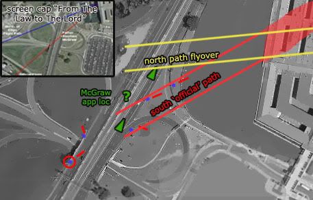
8) Father Stephen McGraw
*Alleged witness DoJ lawyer and spooky just-ordained Opus Dei Catholic-priest* Stephen McGraw has described the flight path as from directly over his car, about 20 feet up and descending ahead of him and to his right to the impact point where he clearly saw it impact. He even told this to Aldo and Craig, and so all we need is his location to draw the path to the building, which CIT didn’t think to gather and hasn’t tried since. This line should also include, as McGraw deduced afterwards, the light pole that was clipped “just before it got to us” and the taxi damaged by it (see England, below) that was “just a few feet away from my car.” The plane passed from over the pole/cab area to over him and descended ahead all on a line he feels was “controlled and straight” into the building and CIT dismisses him as a “no-pather” witness and highly suspicious. CIT got no verification of his location, and they doubt he was at the scene at all, more likely fabricating for his Opus Dei NWO masters. He was placed in the correct spot (“a few feet” from England’s taxi and ahead of pole 1) in their graphics, “because we are typically discussing his account in the context of the official story,” which, in CIT land, is now a proven lie.

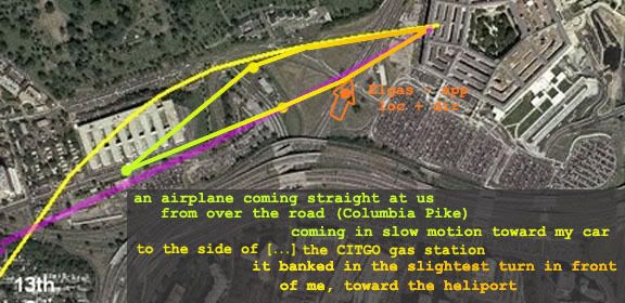
9) Penny Elgas
Headed north on Route 27 “almost in front of the Pentagon,” Penny Elgas reported “I heard a rumble, looked out my driver's side window and realized that I was looking at the nose of an airplane coming straight at us from over the road (Columbia Pike) that runs perpendicular to the road I was on. The plane just appeared there - very low in the air, to the side of (and not much above) the CITGO gas station that I never knew was there.” Finally a witness that mentions the Citgo, and a reason others don’t, and a side! It’s tempting to simply declare it was passing along Columbia, which puts it south, but she only placed it over the road. Below I offer NoC and SoC variants for comparison. She recalled it coming “toward my car” and passing low “about 4-5 car lengths in front of me.” Along the way, the plane was descending and “banked in the slightest turn in front of me, toward the heliport.” Left or right turn? Coming from NoC, it’d have to bank right, which means right wing low. South path could be level and straight or, some evidence shows, banking slightly left wing low. With the right wing closest to her, Elgas said “I saw the end of the wing closest to me and the underside of the other wing as that other wing rocked slightly toward the ground.”

Straight at her, banking left and passing ahead of, and then impacting, which she is quite clear on. She actually had a piece of the plane
land in her car
, confirming her location about under the plane as it started losing parts, which a NoC plane would not do. She is a south path witness, plain as day, and no hunt was necessary. Why does CIT still claim no published SoC witnesses even though this one is quite well-published? Oh she’s all kinds of suspicious, her account is too public, too detailed, the plane part thing is too weird, and she has government connections. Not a real DC witness and not worth talking to. “Penny Elgas has a significant position in government and a very high profile highly publicized account so should be instantly considered suspect," they say.

10) NEIT 567
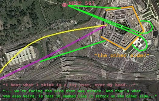
This witness is among the CMH interviews, designated with a number like the rest, and according to CIT “one of the most compelling accounts.” A member of an Army band who was at the ANC, her location as read by CIT is actually accurate, I believe, and labeled below. Partial account:

“I hear what I think is a fly over, over my head because that's standard. [...] And I looked, I looked directly up for it, and I also had some tree cover so I wasn't able to see, but I was facing the Pentagon [...] And we're facing the site that was struck. And that's what was also weird, is that it seemed like it struck on the other side whereas I found out later, I saw [the impact point?] so that whatever plane that disappeared, it was it happened so quickly.”

Aldo Marquis announced “She describes the plane as being "over my head" and having looked "directly up" for it which can only be the north side flight path,” which is not true. It would be A north path, but nowhere near the one they’ve been promoting. “Tree cover” implies a lateral distance with several trees in the way, rather than straight up through a single tree’s branches. This means it was at some distance, I think we can all agree to the south. Marquis also trumpets how she “thought that it flew over the Pentagon and crashed on the other side!!! […] Sounds like a flyover account to me.” She said no such thing. What did she mean about the other side thing? She knew where it hit, so we have four choices to work with here, below. Only one makes sense to me and it strongly implies a south path with perspective error.

ETA: A more detailed debunking of her inclusion as a CIT NoC witness

11) Steve Riskus
Headed south on Route 27, well north of the crash site when he saw the plane come in low and crash square into the building. When offered a graphic showing two possible flight paths he explained “The plane looked like it was coming in about where you have the "MAX APPROACH" on that picture... I was at about where the "E" in "ANGLE OF CAMERA" is written when the plane hit...”
He erroneously gives his distance from the plane about 100 feet or so when he actually would have been over 1,000 feet up the road from the plane. A 10x factor mis-estimation might seem unlikely, but he himself placed the plane about right on the map and just that far away. Just not a numbers guy apparently, but definitely a south path witness.
Riskus also said “It knocked over a few light poles in its way,” but has affirmed to others and to me in an e-mail that he did not actually notice this event. Like most other pole-impact witnesses, he admits deducing this from the evidence and, one might suspect, from the match between the observed path and damage.

12) Wanda Ramey
However, at least one observer bucks the trend – DPS/PFPS officer Wanda Ramey says she saw the poles clipped by the plane. "I saw the wing of the plane clip the light post, and it made the plane slant. Then the engine revved up and crashed into the west side of the building.” Ramey says, explicitly, that she saw this, unlike most other deducing light pole witnesses. CIT say they have tried to find her and verify that she truly differs from the others, but have had no luck. The original article described her as having “a clear view” from “the mall plaza booth.” My best guess as to the exact location of this is included below, and gives here a wide-angle view from a moderate distance of about 900 feet from the pole impacts. Perhaps the key to noticing the pole pruning is distance, not closeness, as CIT have presumed.
ETA: Ramey was at some point interviewed by CIT, and they have made the audio available. They'd been trying a while to get ahold of here to confirm or deny that she saw the poles actually hit. She could do neither, after years of memory atrophy, etc,, couldn't recall if she actually saw that or not. She does however specify a left bank, the "slant" being the wing nearest her lower than the other, which further supports the south path.
13) Lloyd England
So suspicious is this elderly cab driver that he gets his own short video; ‘The First Known Accomplice?” It’s not surprising that CIT and their allies make a huge deal of his account all over the place and put his damaged taxi cab on their main page. Unluckily for their case, he’s the best light pole witness, who says plane that passed right over his car “was so low it hit the light pole. And when it hit the pole it knocked the light part off and nothing came through the car but the pole itself." He screeched to a halt at an angle there, he says. “Did you actually SEE the plane hit the poles,” the old CIT standard, gets real silly in this case, but oddly enough, even Lloyd, who was closest of all, failed to actually SEE the pole(s) being struck, and offers a possible clue to why others missed it. He told the CIT/LTW/Pickering “elite research team” “this airplane flew over top of my car. It was real close, and uh, I just looked at it. And when I looked at it flying over, something - [glass?] - a loud noise happened and the pole came through the dashboard, right through the car, all the way to the rear.”

This looks bad for their planted light debris theory. Luckily, the specifics of England’s accountare problematic. He has clarified in detail how the big curved pole segment is what stabbed his car and nearly killed him (the one out front in the picture below). That this would enter the windshield and come to rest long heavy end out as he says without leaving a mark on the hood doesn’t make much sense. This proves nothing except that a witness is telling a story that apparently makes no sense; his windshield was likely damaged by a different pieces than he says, and he constructed the memory he’s shared, perhaps honestly or perhaps not. This shows why witness accounts are weaker than objective verifiable evidence, but CIT is determined to make it a strong something. Since “his story is physically impossible and proven false by the evidence,” they’ve decided he was actuallt involved in the planting of the pole and was making the story up to cover for it. They’re unsure if he’s a willing accomplice or simply a “coerced […] victim,” but simply wrong is not an option, nor is it conceivable to them that he’s actually right, even though most people who think it out can’t see how.

As the CIT video asks of this account, “isn’t it interesting how Lloyd’s story supports the official flight path while being irreconcilable with the eyewitness flight path?” That’s right – not a witness. “At this point the debate regarding what happened at the Pentagon boils down to whether you choose to believe the CITGO witnesses or Lloyd.” Well whaddya know, a fasle dichotomy.

Conclusion: 8=0?
CIT’s wild-eyed fast talker Ranke recently reiterated the bogus claim yet again, in response to Mangoose at the JREF forum: “None of the witnesses we spoke with placed the plane on the south side of the gas station.”

Alright then, just from this list of people who place (or at least strongly imply) Flight 77 SoC, they spoke with Zakhem (understood her south path testimony, and used it to dismiss itself), Vignola (breaking agreements and burning bridges along the way), and with that liar Wheelhouse (it was THEY who gave him the paper to draw his south path on!) When they talked with Paik, and got him to draw lines that were either NoC or OtC they also video-recorded his south-path-supporting gestures. They of course talked to Morin, Ranke says, and I think they talked with Riskus via e-mail as it seems everyone has. McGraw spoke more with Avery and Pickering, but CIT was present at the taping, and they used the footage in a video dedicated to tearing down and obfuscating his south path testimony. Same with Lloyd England, and they even make it look like they defied ‘the devil by stealing his cab light. Where’s Mr. T when you need him to defend his fellow DC cab drivers? So just out of these thirteen south path witnesses, the CIT have spoken with EIGHT! Of these eight witnesses, at least four have been strenuously dismissed as non-witnesses of the most sinister kind, doubt cast on two, and two distorted and claimed as NoC after all. So by CIT logic, no, they haven’t found any south path witnesses in their journeys and likely never will. That’s just neat how much they’re winning. Good for them.
---
Post-13 witnesses with no graphics guaranteed:
14) Here's another, if weaker, SoC witness, using Aldo's formula for NEIT 567: Levi Stephens, who later is said to have said it was NoC, had earlier said "I was driving away from the Pentagon in the South Pentagon lot when I hear this huge rumble, the ground started shaking … I saw this [plane] come flying over the Navy Annex. It flew over the van and I looked back and I saw this huge explosion, black smoke everywhere." Now no one is saying it was directly over the van, but how far NoC could it be and even seem that way? Hasn't he been placed around the lane one area? Why does he report a plane over there before the explosion rather than "after" like Roberts?
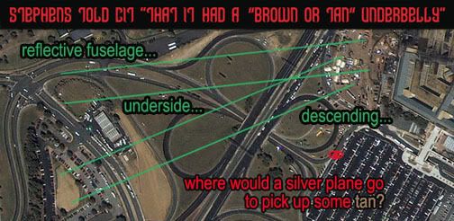
ETA: Also, a real SoC view is strengthened by CIT's own interview with Stephens, where they say he says it was north of the Citgo. As if it helps their case, they point out how he thought it was not an AA jet due to its unusual paint scheme - including a brown or tan underbelly. No one else really reported this (except I think Omar Campos), and most people thought it was a silver in color, as AA would be. Funny enough, the bottom of a silver plane would reflect the colors beneath it. A north-of-Citgo path would mostly show grass green, while a SoC passage would put it over the brown or tan unseeded, just built dirt mound just south of the station.
15) Roosevelt Roberts: Speaking of Roberts, his full interview reveals quite clearly a witness to Flight 77's actual SoC approach. It was a silver airliner with jet engines, he saw it in the space to the west over the south lot ("around the lane one area"). It was coming from the west ("from the 27 side ... heading east towards DC", from the southwest, past where I-395 merges with Route 27, from "almost like where that ne- that first plane had, um. . . flew into the, um, Pentagon right there. It- it- di- it looked like it came from that direction." And it was banking about 50-100 feet above the ground, just above the light poles. All the stuff about a second plane headed away is made up. The "another plane" he saw was clearly NOT after 77's impact, if he saw it coming in on the path 77 took, at its altitude, with its appearance.

16) NEIT 405: Another CMH interviewee, on one of the walkways on either side of the loading dock at the south lot. So nearly the same position as Roberts. "Walking on that elevated area that's right outside the door. It's actually on the second floor level. And I turned and glanced off to my right [...] I saw a plane coming over 395 and very, very low. Essentially coming into eye level as it flew across 395 and come across the end of the south parking off to my right as I went through that door." Across 395 probably means 27, and it appearing over the end (lane one edge) of the lot indicates it was probably SoC.

17) George Aman: CMH witness NEIT 419, Arlington Nat'l Cemetery facilities manager, inside a south-facing office at the time of the attack. He saw the plane descending and impacting out the window, and said so to CIT. His ability to determine just how far away it was or what it was over, would have been very limited. He placed it as passing between the Citgo and the ANC south maintenance parking lot. That's north of the Citgo, about as far north as witness should be expected to warp a plane passing them over a great distance. [Fuller explanation]. So how on earth is he a SoC witness? Light poles. CIT says no one actually saw them get hit. Ramey had said she did but can't remember now when they ask. Brooks said he did, but recanted to CIT. It was deduction, he said. George Aman, from his perspective, had a clear view of the first poles up on the bridge mound a few hundred feet away, and had said back in 2001/02 "When I was looking over here and I seen things fly up in there, not knowing really what the hell they were but come to find out they were street lights. So the plane was clipping the tops of the streetlights off." CIT had every chance to ask him if he deduced this, but just decided instead that he clearly was and it wasn't worth asking. [see comments at link above] They know he's a SoC witness.
Sunday, July 27, 2008

LIKE TWO BULLDOZERS

NEIT 749 PHOTO SHEDS LIGHT ON DAMAGE PATH
Adam Larson / Caustic Logic
The Frustrating Fraud
July 27 2008


Whatever I think of some of John Farmer’s propositions, I have always appreciated his unparalleled use of FOIA and other channels to increase the body of available data about the Pentagon attack. Among the three dozen plus Center for Military History witnesses he’s obtained so far, one at least brought additional material aside from testimony. This witness is designated NEIT 749, a Helicopter Pilot with the Fairfax County Police Dept. He was not a witness to the event, and only saw the aftermath from the air. When he was interviewed by CMH in late April 2002,they also collected at least some of the officer’s photos, which Farmer was able to retrieve copies of, in mid-resolution, and share them at his site. He does ask that they be cited to Center for Military History / Fairfax County Police.

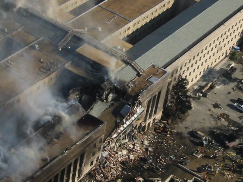
As far as I can see, these are all-new, never-before published images, 24 of them, most aerial long-shots of the damage and recovery staging areas. There is really nothing much revolutionary in the images that jumps out at me, but perhaps I’m just worn out on all this. One, image #100-0008, shows a new view of the downed light poles, partially assembled at the guardrail. I’m not sure yet if there are any new clues in that pile, that’s for later. For now I’m struck more by image #100-0028 (above), an early aerial shot from just north of the impact area and looking across the pre-building damage area at a unique angle.

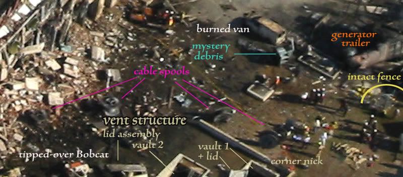
“Obstacles” of note labeled are in this enlarged crop, most previously identified in my “obstacle dodge post. For some stupid reason, a lot of entities have latched onto the cable spools as evidence against a large plane strike. I’ll look at that a bit below. The diesel-powered generator trailer and fence are of course widely noted as evidence for the right engine’s passage through that corner of the construction area. The ‘mystery debris’ I had previously thought perhaps part of the generator, but here we can see right behind it a concrete footprint (parked’ behind the van), to which something had apparently been attached. I looked at the vent structure in detail later, Its corner was famously nicked by the ground-level left engine, but hardly anyone has looked at the inside elements of this recessed structure. ‘Vault 1’ as I’ve labeled here was apparently scraped over, its hinged door pushed back and warped (see above post for closer side-photos) What I’ve here labeled vault 2 is probably the original resting place of the propped-open door assembly dented and hurled back. This is visible as a tent-like shape in many photos (here only half-visible). A tipped over Bobcat tractor as previously seen is even further behind that.

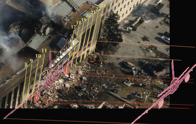
Without reference it seems a chaotic scene. But I have reference, and this photo also allows us a unique view of the area where I can line up the column lines and the “official” plane profile relative to them, and trace this back.

The tipped fuselage would have a clearance of perhaps ten feet at the right, and perhaps five at the wall. Its right side/wing faring a bit higher than the left. The famously non-tipped, non-damaged 6-foot cable spools furthest from the building were thus likely passed just over, and the one at center likely rolled a bit from the right – probably on wake just after the plane passed. The two further in seem to be spread away from the others right along the fuselage path as it descended, and tellingly, it’s these two that are tipped over and of course singed/burnt from the intense deflagration at impact, which they were in the range of.

Otherwise, the fuselage had little real effect prior to the building, and it’s the engine paths that are interesting here. All evidence puts their impact points roughly at column lines 11 and 17, the left engine at ground level and right engine a bit higher, These I traced back from impact in orange, along the ground (width app, slight perspective skew). Refer to the above graphic where the objects were highlighted and compare to these areas. The general excellent fit stands out, as framed by the fence damage and vent corner nick, and as everyone has noticed. What pops out here, aside from the curious lack of clutter in the actual engine troughs, is the precision of the lines marking their paths. The trailer and mystery debris on the right, both seem pushed aside just far enough to let pass a barreling multi-ton RB211 engine. On the left, the lid from vault 1, the lid assembly from vault 2 or wherever, and the Bobcat’s direction of tip all clearly follow the rough outer edge of the left engine’s swathe. Forward (on the plane’s path) and to the right or left, depending. Like two low-flying aerial bulldozers came in on the “official path” to fake us all out.

That is what some “investigators” would call a suspiciously precise forensic clue – like so much else about the attack, it just lines-up a little too “cookie cutter.” Would a real airliner fake an airliner’s damage so perfectly? Short answer: yes, it would, and it probably did.

Saturday, June 14, 2008

MORIN: THE CONVENTIONAL WISDOM

MORIN: THE CONVENTIONAL WISDOM
Adam Larson / Caustic Logic
The Frustrating Fraud
June 14 2008 3am
edits update 11pm


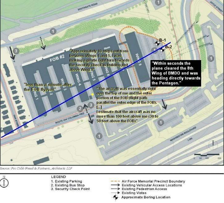
Pentagon attack witness Terry Morin, September 2001 at the Navy Annex/FoB #2:

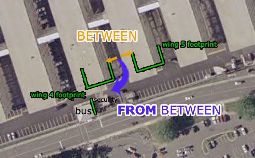
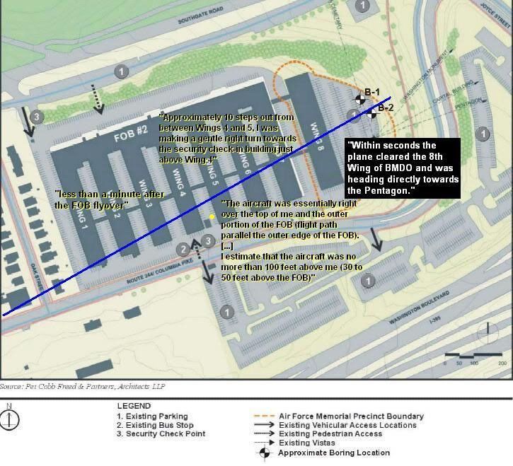
“Approximately 10 steps out from between Wings 4 and 5, I was making a gentle right turn towards the security check-in building just above Wing 4 when I became aware of something unusual.”
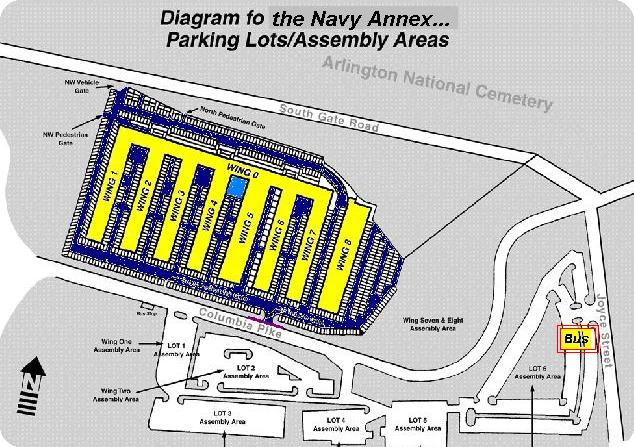
According to this graphic, the larger structure to his right here is the bus stop and the smaller one security (thanks CIT). These sit astride the high-traffic crosswalk to the parking lots across the Pike, including, according to this graphic, lot 3, to which he said he was headed (thanks Bobloblaw).

“I started to hear an increasingly loud rumbling behind me and to my left. As I turned to my left, I immediately realized the noise was bouncing off the 4-story structure that was Wing 5. One to two seconds later the airliner came into my field of view.”

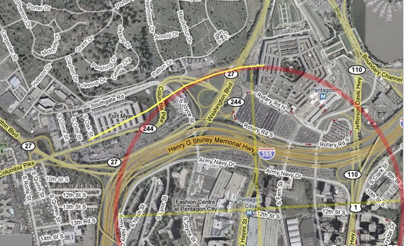
Where exactly and how far out? Officially, southwest, about straight ahead if facing the bus stop. The distance is far from clear, but given that it was traveling at near the speed of sound, it couldn't be much behind its noise, perhaps passing the Sheraton hotel. In the below graphic, the “official” flight path is placed approximately based on all available data, and is a general fit for Morin’s description, below:
“The aircraft was essentially right over the top of me and the outer portion of the FOB (flight path parallel the outer edge of the FOB).”

The use of ‘essentially’ in conjunction with his otherwise detailed account shows he means it was very nearly over him but not quite. “Parallel” I take as an accurate observation but not necessarily 100% precise. The real path of Flight 77 does in fact run about parallel to the building’s edge, as seen here. Also, parallel is a word describing two different lines. He did not say “along the edge,” so it was probably centered either north or south of that line, and if north, his failing to describe it as over the building is curious.

“I estimate that the aircraft was no more than 100 feet above me (30 to 50 feet above the FOB) in a slight nose down attitude. The plane had a silver body with red and blue stripes down the fuselage. I believed at the time that it belonged to American Airlines, but I couldn’t be sure.”

Seeing stripes indicates, as he said, that it was not directly over him (unless in a severe sideways bank, which neither he nor anyone mentions). It was either some combination of south and banking left (and he’d see the left/port side), or north and banking right (in which case he’d see the right side). The former seemed to fit his continued line-of-sight, nearly up to impact, and of course also fits with where the plane actually was and where Morin said in 2001 that he was. He describes his continuing view thus:

“Within seconds the plane cleared the 8th Wing of BMDO and was heading directly towards the Pentagon. Engines were at a steady high-pitched whine, indicating to me that the throttles were steady and full. I estimated the aircraft speed at between 350 and 400 knots. The flight path appeared to be deliberate, smooth, and controlled. As the aircraft approached the Pentagon, I saw a minor flash (later found out that the aircraft had sheared off a portion of a highway light pole down on Hwy 110). As the aircraft flew ever lower I started to lose sight of the actual airframe as a row of trees to the Northeast of the FOB blocked my view. I could now only see the tail of the aircraft. I believe I saw the tail dip slightly to the right indicating a minor turn in that direction. The tail was barely visible when I saw the flash and subsequent fireball rise approximately 200 feet above the Pentagon.”

His lateral line-of-sight would be set by the edge of the 8th wing’s SE corner. This would completely block his view of anything too far north, and this path does have something of a north trend. His approximate line-of-sight then is represented by the yellow line in my second graphic, above. Note that the last stretch of the path and the impact itself would be invisible from his angle, unless he moved significantly south.

He also specifically mentions a vertical line-of-sight, defined by a row of trees running along the crest of the hill east of the FoB. In the analysis below, descent rate again approximated, the point where he’d lose sight of the plane appears to work out to about the same location – that is, it went too far north to see at about the same time it went too low, all at around the yellow line. I'd venture from these rough renderings that it would disappear below the horizon just before passing behind the building. So in two ways he would absolutely not see the plane all the way to impact. The reason I explain this is to defuse the importance of Rob Balsamo’s neat little video using 3-D graphics to show the same thing I decided with my graphics, so it's a useful visualization (scene below) – it shows the plane shrinking to the corner, disappearing vertically just before it was about to do so laterally.
This revelation fits with the placement above and with Morin's first losing it behind "a row of trees," not the building. It only appears damning and contradictory when contrasted to this line, sometimes misused by ‘de-bunkers’ and here misused by a re-bunker:

“The tail was barely visible when I saw the flash and subsequent fireball rise approximately 200 feet above the Pentagon.” [emph. mine]

First, “when” cannot be taken too literally when micro-second time differences are at work. Second, the flash may be a light pole being “planted,” catching a glint of sunlight as it “danced” in the air. It may have been a glint off the plane itself as it banked, depending on the angles, which I haven’t analyzed. But clearly it occurred in his line-of-sight, and southwest of - before - the “subsequent fireball.” His narrative does put enough detailed emphasis on seeing tail, and “believing” to have, that it appears he’s embellishing a bit. Vagueness of language aside, he is clearly supplementing his memory with additional info (time: "call it approximately 9:36 AM"), and it would seem embellishing some gaps - tiny, tiny gaps. Perhaps it seemed to him that the “official facts” lined up with what he saw and heard, and if so such synergizing is only natural.

So this is the conventional wisdom, or rather my understanding (which is just a notch above that), of Terry Morin’s account. It corroborates the "official story"/real flight path so well in fact, that he's been strenuously dismissed by critics like CIT's Ranke, who back in November rattled off a huge list of perceived inconsistencies and stated paradoxically “due to all of these extreme contradictions with the official story and explicit exaggerated details meant to support it [...] it's clear that Morin is either relaying a completely fabricated or else wildly embellished account.”

Well, if Ranke today is to be believed, simple embellishment is out the window at least, and Morin himself proves that Morin was fabricating virtually everything in his account, possibly in cahoots with the planners who knew how it should look. Ranke says Morin affirmed, in a private, off-the-record discussion recently, that he was actually “between” the wings rather than “from between,” (see first graphic). This is just as CIT had always reasoned against all reason, giving him the view of a toaster pastry that completely invalidates everything above and any reason to believe what he says now.

If Ranke today is to be believed… and that’s an if alright… then Morin the proven fabricator who was likely complicit now helps prove the truth seven years later and “most definitely should go on the list of people to subpoena once the hearings begin.” Once again the mighty CIT has shown us how much we all know. I have some things to say about this ridiculous turn, but I’m taking it steady right now, and will report more fully as soon as it seems reasonable.

Thursday, June 12, 2008

REHEAT, REASONING, RADII

REHEAT, REASONING, RADII
Adam Larson / Caustic Logic
The Frustrating Fraud
June 12 2008
a bit rough


Note: Lest Reheat think I'm being too harsh on purpose, lemme just say, nah! This is important work and he's right in general, I'm sure. I've just spotted a few things, and I'm such a contrarian...
---
JREF member and anonymous retired Air Force pilot “Reheat” has been offering mathematical proof of the impossibility of CIT’s NoC flight path for a while now. His new paper Debunking the North of Citgo Theory, as published at 911myths.com, further develops the theme, and spurs me to finally note his work. This additional nail in the coffin is couched as “an analysis of the aerodynamics required based upon witness testimony,” a novel approach to the north path analysis – check if it’s possible before asserting it happened and proves that other things didn’t. It’s encouraging to me that someone else feels it’s worth the time to engage this silliness earnestly. I often feel hoodwinked for arguing against something so stupid, but I have nothing to blame but my own obsession. And Reheat has taken issue with the same theory and gone and done math about it – imagine how twisted his mind must be!

His assertion, in this paper and previously, that “the calculations are aircraft type independent” has caused some confusion, and the first thing I did was ask him to clarify. To summarize as I understand it, these numbers WILL apply to any fixed-wing aircraft in the presumed turn, but exactly HOW the G-forces apply depends on the craft. F-16 could do better than 757 with the same turn. The details still escape me a bit, and so I’ll just let the paper speak for itself and offer Brainster’s accurate summary that Reheat has “taken the Morin and Paik flight paths, and then shown the turns necessary to be where the Citgo witnesses claim, then done the calculations to show the stress that the planes [sic] would have experienced trying to make those maneuvers, and that they would have stalled out.”

What I can offer now is some focus on the operative concepts and logic behind this effort, where CIT and allies have claimed straw man, faith-based argument, general scumminess, and disinfo. Unless I’m reading wrong, they have some cause to complain. The paper explains the start point, with witnesses “Edward Paik and Terry Morin who place the aircraft flying parallel to Columbia Pike. There is no problem with this portion of the testimony as it was stated, without CIT’s spin.” The problem is that CIT’s spin is part of what they have decided and the reason this proposed flight path exists to debunk in the first place.

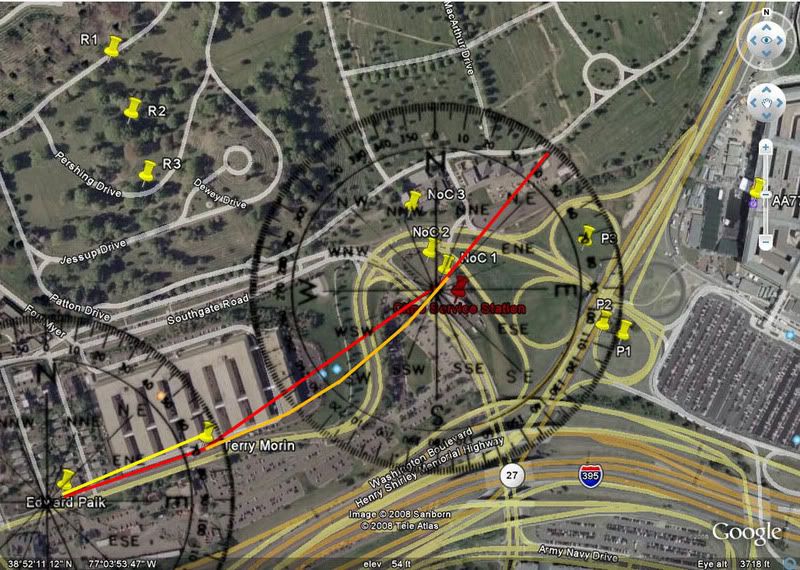
Reheat places Morin where he actually describes himself, but has the path going directly over him there, in a straight line directly parallel to the Pike/FoB edge that has no turn at all from Paik’s position (Paik>Morin listed as requiring 0 degrees of turn). This is the red line in graphics below, on a heading of 72 deg, which is close to reality I’m sure, but not fit for this exercise. Paik himself drew several paths crossing the annex at an oblique angle, which must be ignored to use only gestures from an earlier testimony. And according to CIT, Morin was north of the spot Reheat chose, between the wings of the Annex, as they decided with this ridiculous graphic. Marquis: “when he saw the plane for the brief instant it would appeared parallel to the outer edge of the FOB-which, again, is where the flight path was at; the outer edge Also I am sure he meant it figuratively and not literally, since he can't see the entire flight path.” [not their path from this location anyway – source]

In short, the way I see it, if you want to debunk CIT’s flight path, you need to realize it’s a fiction THEY wrote based on certain interpretations and take those into account – like ignoring the low impact aspects of their Noc witnesses. We’re already factoring that out and presuming a flyover and looking here at lateral turns, NEWS. They did not propose a path literally parallel to the FOB, so including one will distort the path. And it puts one in the line of arguably valid straw man accusations.

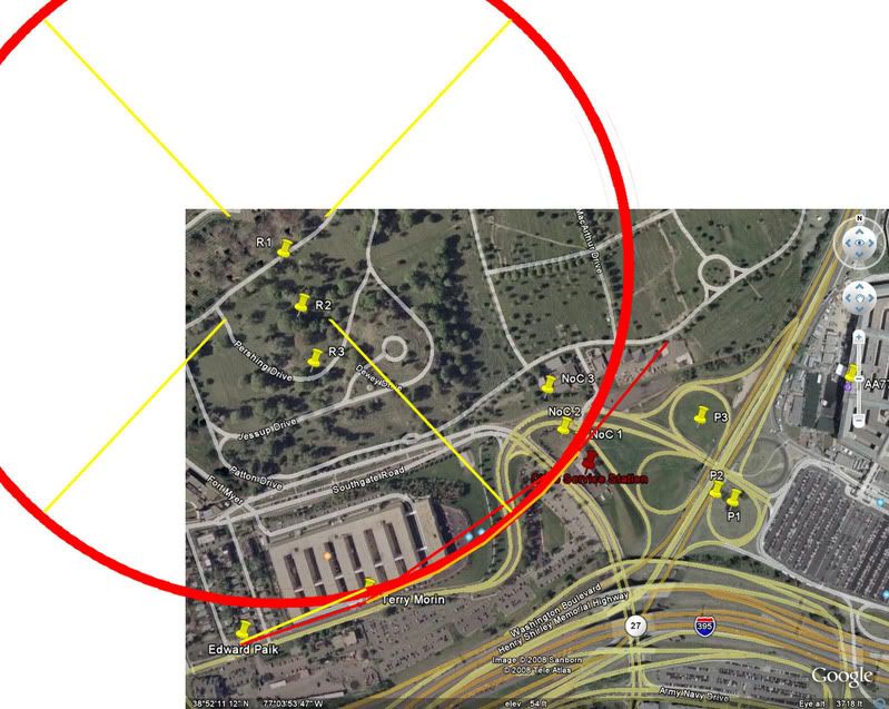
Next: a bit technical, sort-of. To be sure I understood the concept behind his turn radii, I stripped away the numbers and made it visual, which helps me. I looked first (and only) at the most moderate curve. I connected the Morin point to the NoC 1 pin, then drew in a simu-curve (orange) to average the heading change more realistically.
Next I checked the headings at Morin and att NoC 1 and found app. 72 and 40, for a change of 32°, which is a bit off from the numbers on the chart, but close enough for what I’m doing here. Then I set a circle around the R1 pin and found it traced that same curve. So this is the right center presuming the plane started south of the Annex at Morin’s location. From there we have another center point for the second turn to impact, this time labeled P1. (“The tags P1, P2, and P3 are the center points of the turn radii for the NoC locations to the impact point at the Pentagon.”) Following the same pattern, we get a curve like this: Which gives us a final flight path like this for NoC1: Now I understand maybe that's part of the point here, but CIT never proposed anything like that, and never needed to. As whoever it was stated in response, Reheat “twists it (pun intended) even more with an S-Turn? Now there is no doubt in my mind why he wants to remain anonymous. Too funny. He must really be desperate to put an S-Turn in there.” Indeed, if I’m reading it right, there is a pronounced S-curve to the proposed path while CIT’s proposed NoC path is all one arc (blue above, their most moderate proposal). Yes, this means Morin was really fudging, but who can disprove that? It's not much further from what Paik drew - his exact lines works for neither official nor NoC paths without fudging. Reheat’s initial straight path as far as the FoB has an edge to run along requires a left and then right bank, whereas CIT has argued for a single right bank over the whole span and crossing the building. These are two different flight paths.

And as far as the degree of the second turn, JFK’s criticism – for once anyway - seems valid here. Unless I’m missing something, there’s no reason “the tags P1, P2, and P3” need to be THE “center points of the turn radii for the NoC locations to the impact point at the Pentagon.” It doesn’t need to fly the full arc 180° - it could fly nearly straight after the Citgo starting from a less northerly heading there. Let me help out here with a possibility:
Someone else can crunch the numbers on that.

If nothing else, this episode illustrates the absurdity of trying to concoct a real flight path from witnesses by focusing on discrepancies rather than correlation, and the dangers of selective reading - someone, or some part, always has to get thrown under the bus. And besides, if someone "must really be desperate to put an S-Turn in there,” someone needs to look into the chaps who put out this desperate s-s-s-swerve a while back and started all these tortured calculations.

Friday, June 6, 2008

RADAR = VISUAL = SOUTHWEST

RADAR = VISUAL = SOUTHWEST
Adam Larson / Caustic Logic
The Frustrating Fraud
June 6 2008


I could have posted this sooner, but it deserved some careful prep, and I’ve enjoyed CIT’s maneuvers in the interim. Sorry fellas – I did set it like an ambush, but didn’t expect it would actually work so well and so quick.

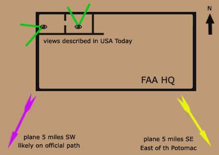
Recently I was able to contact FAA’s Colin Scoggins about his 9/11 report of a plane seen (I presumed) on radar southeast and/or southwest of the White House just prior to the attack. I was thrown for a loop when Scoggins told me it was a visual sighting from FAA HQ in the Capitol, and it seemed he was saying it was therefore NOT a radar report.

That wasn’t even my original question, but I poo-pooed this notion, given the great distance to see it. I did do up some scale experiments that indicated “they certainly would be able to visually pick it out" - barely, as a speck - "if they were first tipped off by, say, a radar report of a plane five miles southeast, er, southwest. But to notice it with no prompting makes little sense to me.”

In the comments at the above link, Craig Ranke of CIT showed his enthusiasm for this revelation and his own idea for the prompting in question:

“So Scoggins is 99% sure it was a visual from FAA HQ in downtown DC! Wow. Great work! Clearly that destroys the NTSB and supports EoP.
[…]
It wouldn't take a "hawkeye" on the DC flight path if they saw it pass their building over DC and kept following it and this does not make any sense AT ALL with the NTSB or alleged radar data!
[…]
>>>>You'd guess they were prompted by the over DC path to keep following it then?
If there is any truth at all to the this visual reference then it is the only explanation. Naturally any plane at all in P56 airspace would alert attention.”

[how about the outbound C-130 over the mall’s south edge? Any witnesses outside the plane?]

Ranke even started a thread at their forum, the last before the valuable threads posted later on “Tramsoccalpra” and “Hydrociault” that were REMOVED! (Censor Nazis ;))
DC flight path - East of Potomac evidence, further confirmed by ATC Colin Scoggins
, about how “CIT obsessed Adam Larson did a little investigating of his own and ended up CONFIRMING our claims!” He presented a fuller argument that does make sense given the state of the evidence yesterday, used my graphics, and even linked to the original as a valuable piece of research, if riddled with obfuscation and whatnot. Amazing. Cue the sparkly CIT lyte trip-hop music, this goes in the revised how they forgot to scratch Lloyd's hood and other addenda video...

As far as Ranke’s interpretation that a visual encounter supports the DC flight path, this does make some sense, depending on how much evidence there really is for it being over DC before this (hint – it’s a CIT claim). For CIT it’s a no-brainer since they already believe it was over DC and THIS is what prompted them to follow or project it south, southwest, and so on. But here’s a different, more informed insight, from another Scoggins e-mail just as Craig started posting stuff:

"This [is] taken from the USA Article I mentioned. This is the TELCON I beleive I was on. I am 99% sure. The call came from FAA HQ, and they were on the West side of the FAA HQ building, and Dave Canoles must have been on the North side, so Dave's office was a corner office or it was real close to the corner. "

Cue the record-scratch sound. Indeed. I had heard this article mentioned but hadn't read it, and apparently neither had Ranke. The whole article, from just after 9/11, is still available here. These are the relevant excerpts:

At FAA headquarters, less than a half-mile from the White House and Capitol, Dave Canoles paces before a speakerphone. The head of air traffic investigations, Canoles has set up phone connections with air traffic facilities. […] Now, about 9:35 a.m., he and others on the conference call listen as an official watching a radarscope tracks the progress of the jet heading for Washington

So my either-or impression was a false one based in my ignorance of this piece. Canoles is probably the muted voice we can hear behind Scoggins in the NORAD tapes, and he was first tipped off by another person elsewhere watching the radar track. This makes perfect sense, and then the visual part comes in, prompted by radar. Is there a clue in this to what the returns said?

“Canoles sends an investigator who works for him to an adjoining office with a view to the west. "See if you can spot it," he tells him.
"Six miles from the White House," a voice on the phone says.”
Canoles glances outside, through a window facing north. He wonders if he and his co-workers are in danger. At 500 mph, the jet is traveling a mile every seven seconds.
"Five miles from the White House."
No way the FAA is a target, Canoles thinks. It can't be.
"Four miles from the White House."
They'd never choose to hit us. No way.
"The aircraft is circling. It's turning away from the White House."
Where? Where's it going?
Then: "It's gone."
In the adjoining office, the investigator spots smoke to the west of the city. The jet has hit the Pentagon. The time: 9:38 a.m.”


Scoggins feels this account “flat out tells me that it is visual,” but I don’t really see it. There is talk of windows and attempts to see, which is a hint it might have gone there, but the only thing that’s clearly mentioned actually being seen is the smoke afterwards. Now since the investigator is in an adjoining room a phone bridge seems unnecessary, but it is possible he’s the one on the phone giving the updates based on what he’s seeing out the window. And it’s at least as possible, not knowing more, that these are from the same radar operator that got them started.

It’s not clear from this alone if there was ever a visual sighting of the plane, but Scoggins also heard what Canoles actually said, in the telcon we only hear murmurs of, and he is left 99% certain there was such a contact. I’m inclined at the moment to believe him. So treating this as an eyewitness case, let’s first note that the USA Today piece mentions a view to the north, meaning Canoles’ office was on the building’s north side – he had an investigator go into an adjoining, but different office, with a view to the west – a corner office.
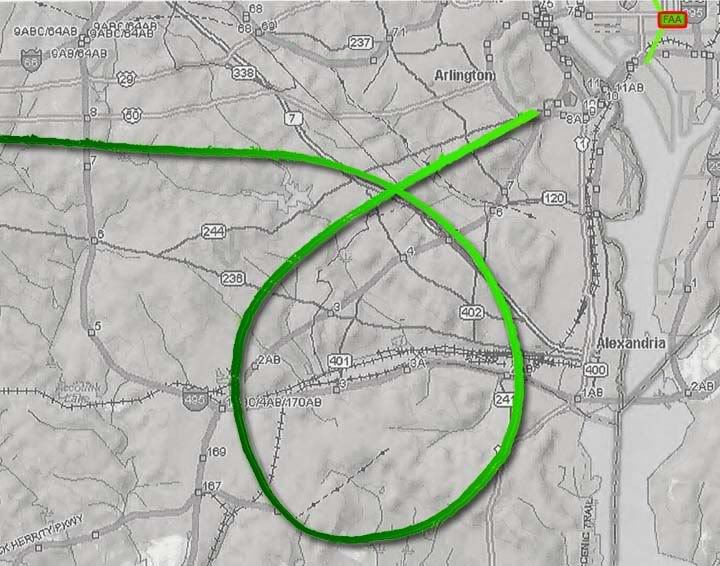
It’s not clear if any sighting would be before the plane turned fully southward from its original path or after the loop and up to the final approach. The witness would not be able to see the farthest reaches of the loop (darker green, below) between these points at all without binoculars. He may well have had binoculars though, come to think of it. He could then have seen perhaps the entire loop, or any portion of it, all from that office with a view to the west.
Now, how can this visual sighting “further validate the east side evidence” if it’s taking place from a west-facing office, prompted by a radar report of a plane in that direction? Originally I offered the quite reasonable and well-supported guess that the southeast report was simple error in reporting a radar track. Then it seemed there was a visual contact instead of radar, which complicated things. Then I learned that this observance was spurred by radar and confirmed southwest, and while we still aren’t sure where the momentary inversion of east and west came in, it is looking pretty much out the window as evidence.

Sunday, June 1, 2008

THE FLIGHT DATA RECORDER {masterlist}

A BLACK BOX SURROUNDED BY A MOAT OF MYSTERY
Adam Larson
Caustic Logic / The Frustrating Fraud
last update 8/24/07
Last updated 3/4/08


Much Ado About... Nothing?

Much has been made recently of the reconstruction of data from Flight 77’s Flight Data Recorder, the so-called black box found at the crash scene inside the Pentagon. The "9/11 Truth" analysis of the data is largely based on the fragmentation of the supposedly coherent data in the flight data recorder (FDR) of the attack plane – different versions have appeared, between which different parameters are found to be "altered," leaving each piece neither totally false and dismissable nor totally true and acceptable. Thus they hover in a middle space to be analyzed by experts – primarily Pilots for 9/11 Truth and their expert allies. Predictably, the data as read and shared offers different answers to different questions at different times, depending it seems on the circumstance. The answers consistently challenge the official account, but fail to prvide a rational alternative, and often conflict with each other…

Various aspects of the NTSB animation based partly on the FDR are covered in my three-part video series "That Darn NTSB cartoon," compiled with notes here.

--- About the Sources ---
- The Evidence Trail - NTSB, FBI, 9/11 Commission, and the National Security Archive keeping the data under wraps, and its final revalation to the public in mid-2006.

- The FDR Specialist's Study: A closer look at the verifiably NTSB-provided FDR data.

- The CSV file

- "Three CD's: Where's Snowygrouch's DVD?" The Pilots' Transatlantic animation connection examined. Snowygrouch and the animation's first appearance. NTSB status at the time: unclear IMO, and yet...

--- Analysis ---
- Pilot X and the 440-foot gap: Altitude Questions raised by the NTSB animation

- Created in Translation: the altitude re-set NOT in the animation - where is it then? at FL018... forthcoming

- A somewhat dated but interesting analysis thread by myself and others @ Above Top Secret: Great insights, explanations, obfuscation, and fumbling with appearances by John Lear, John Doe X, and others.

- Ten Degrees From true: THE "NTSB Animation" is Flat Wrong Demonstrating that the north of the Citgo flight path shown is in fact at least 20 degrees off from the Black Box data it's supposed to be based on.

- Final Altitude: Eight Readings: At least four altitudes attributed the the FDR, compared to flyover "witnesses," and the "official story." I did forget radar accounts which place altitude by accounts of it dropping beneath their coverage just before impact. This is said to confirm the official story and probably does.

- 20 Minutes and 20 Miles from True: CSV longitudinal offset

- NTSB animation internal geography {masterlist} My most tedious chapter yet - five posts with one or two more to come.
- A Turn For The Worse: The culmination of the animation studies above: visual proof that the animation's final overlay map is rotated to about the same tune the plane appears north-of-the-Citgo.

- Csv/animation altitude discrepancy. Kind of a mess, mostly intended as a self-correction.

- CSV final plots: Using timeline seconds to determine geographic seconds.

- Missing Seconds: My Last FDR post

- Bank Notes: Draws on FDR bank/roll readings as part of a larger argument

--- My own NTSB FOIA Search ---
- News Coming A half-ass rundown of why I was finally contacting the NTSB.

- NTSB FOIA Response recieved - no discs enclosed

- NTSB's "Goebbels" and Me When I talked to the director - not important but a tad interesting

- Video: That Darn NTSB cartoon part 2 - the Authenticity Sidetrack Snowygrouch et al. and my discless response explained by me in a video.

Monday, May 12, 2008

SIX MILES SOUTHEAST

SIX MILES SOUTHEAST
Adam Larson / Caustic Logic
The Frustrating Fraud
May 12 2008
last update 5/14 12am


Citizen Investigation Team (CIT) now promote four primary claims regarding the decoy aircraft that everybody thought hit the Pentagon; First and foremost is their original North of the Citgo (NoC) claim, which necessitates the pivotal but otherwise unproven OtP (Over the Pentagon) claim (my own acronym, the others are theirs). This is also supported by the Over-the-Navy Annex claim (ONA) explicitly offered by Paik with supports recently wrangled from other witness accounts. And then there’s the tangential but important East of the Potomac (EoP) aspect, which is at issue in this article. As CIT co-founder Craig Ranke recently said “In addition to proving that the plane was on the north side of the former citgo gas station we can now also prove that it came from east of the Potomac River and actually flew over DC skies! This is absolutely fatal to the official flight path that never has the plane over DC skies at all.” [source]

I haven't tried so far to systematically debunk the EoP claim, perhaps out of fear that it would prove correct. When I finally decided to face my possible fear and finally tackle this case but found I cannot disprove it. It’s a strong enough case I don’t even feel like trying very hard, except on the one point I already did so with. I will have a fuller explanation of my general failure regarding EoP later, for now here is that one evidentiary support that I've looked at closely.

Ironically, this proof of the plane being over the river from where radar shows it is from - people whose job it was to watch where the radar was showing the plane. If CIT's reading here is correct, it would again prove the later-released radar data fraudulent, so it's a big deal. They cite the NORAD tapes, and a 09:35:41 call from Colin Scoggins at FAA’s Boston Center to Northeast Air Defense Sector (NEADS) base “Huntress.” [transcribed from audio]

Boston (Scoggins): “Latest report, aircraft [inaudible] six miles southeast of the White House.”
Huntress: “Six miles southeast of the White House?”
Boston: “Yup. [to someone else] East? He's moving away?”
Huntress: “Southeast from the White House.”
Boston: “Aircraft is moving away.”
Huntress: “Moving away from the White House?”
Boston: “Yeah.…”
[…questions on ID…]
Boston: “If you wanna hold on a second, [inaudible] people down there looking.”
[Long pause – to someone else] “Where was that position?” [backround on Boston end, inaudible with emphasis on last syllable rhyming with yes.]
Boston: “Six.. six southwest, six southwest of the White House and deviating away.” [emph in original]
Huntress: “Deviating away. You don't have a type aircraft, you don't know who he is…”
Boston: “Nothing, nothing. We're over here in Boston so I have no clue. That—hopefully somebody in Washington would have better—information for you.”


The direction of the original deviation isn’t clear other than ‘away’ from the capitol, but CIT is quite confident in placing the plane southeast of there and moving west, eventually crossing the river due south of the capitol, and continuing to six miles away on the other side in time for the update 35 seconds later of it being SW (it was either flying very fast or the second report was much fresher than the first). An alternate guess is it was never east of the river, and the change from southeast to southwest was a correction of the same last reported position.

I could just stop there by offering that guess, but when I tried to earlier, Ranke rebuffed it by stating of the above dialog “that wasn't an accident. He even confirmed it and THEN came back with an update of it being SW which makes perfect sense.” [source] I cannot prove that this is a wrong interpretation; perhaps Colin really was watching the real, pre-alteration radar data when it symmetrically traversed the river. And supporting this possibility is the fact that, as Ranke points out, “Scoggins wasn't the only ATC to report a plane east of the river either.” Oh no, his claim is supported by Major Kevin Nasypany, NEADS mission-crew commander, also from the NORAD tapes:

09:36:23
Nasypany: ‘I got a aircraft six miles east of the White House! Get your fighters there as soon as possible!”
Unidentified: “That came from Boston?”
[…]
Nasypany: “‘We've got an aircraft deviating eight miles east of the White House right now.”


Notice that this report follows Scoggins’ by only 40 seconds and someone feels it may have been based on that info from Boston. Is it possible he’s just repeating the report cited above rather than independently confirming it? Is "eight miles” an anticipated distance, an error, or real info? Does east mean southeast, or had it moved north? Most interestingly, if we take this as independent confirmation, it shows that that plane was not only east of the Potomac, but also deviating further EoP, rather than towards the river to cross west as CIT feels happened next.

Perhaps it’s all a complex cover-up where they altered some parts of the record to hide the real plane while other parts are let through, to provide cover for something, or something. I can’t rule this out as a possibility, but my tentative alternate guess – for whatever it’s worth – is that the report Scoggins received had one error - southwest was reported as southeast, and both Scoggins and Nasypany just echoed this error. A bit of confusion is evident in what Nasypany said later to Vanity Fair’s Micheal Bronner: "Six miles south, or west, or east of the White House is—it's seconds [...] Airliners traveling at 400-plus knots, it's nothing. It's seconds away from that location." That is, they weren’t worried at the moment about which direction the hostile craft would have to fly for a few seconds to hit the White House – they were worried about how few seconds that was, and how to get fighters to that small area fast. They did sort out the error, if that's what it was, but the fighters didn't get there 'til far too late.  
Anyway, you can test this east-west error reading here: refer to this graphic of the radar flight path, marked roughly with lat-long cross-points from the FDR (corrected and approximate), and a 6-mile arc south and west from the White House. Then read the reports below, corrected. update: As explained in the comments below, 6 miles meant nautiical miles which - I think - is about 7 land miles. So note this - the red arc is set a bit too small.
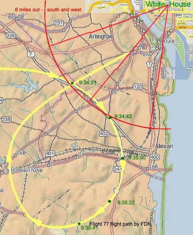
Scoggins 9:35:41: “Latest report, aircraft [inaudible] six miles southwest of the White House.”
“Yup. West—he's moving away? Aircraft is moving away.”
“Six.. six southwest of the White House and deviating away.”
Nasypany 9:36:23: "I got a aircraft six miles [south]west of the White House! […]
We've got an aircraft deviating eight miles [south]west of the White House right now.”


One word, one dyslexic slip in the information chain, is all it takes to turn this into a brilliant indication that the above path is the one seen by radar controllers on 9/11. On the other hand, a different reading could, with a few complications, be found to support the EoP claim, which, again, I still cannot disprove.
---
Update: SPreston has used this "six miles southeast" evidence to say the FDR path is PROVEN a lie.:
"PROVEN: This Flight Path Crossed Over the Potomac, Over DC, and Six Miles Southeast of the White House [...] How come all the witnesses actually interviewed place the actual aircraft east of the Potomac and over Washington DC and 6 miles southeast of the White House and banking around Reagan National? "
None of the witnesses says this that I've seen. One has it looping around from the east (Chaconas and he alone) and this location and distance is not from any interviewed witness, but from the above-described possible error. Almost all other witnesses were west of the Potomac (a few just east as well but looking west). SP, help me out if I'm missing something! Comments open...