October 8 2008 2am
Watch Another NoC Cartoon? in Activism Videos | View More Free Videos Online at Veoh.comFor some reason, the video doesn't seem to play all the way through here, but seems to work fine at the Veoh page, linked beneath it.
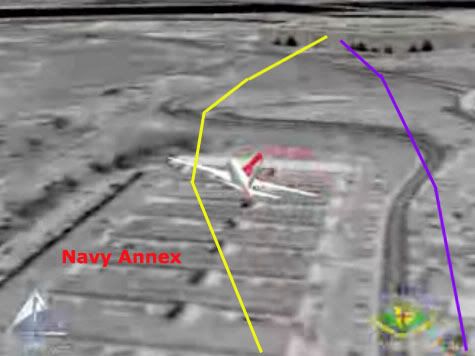
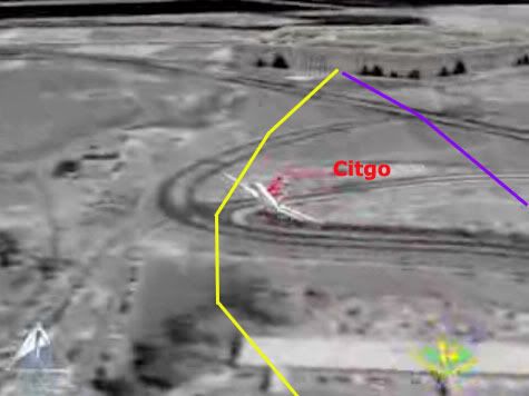
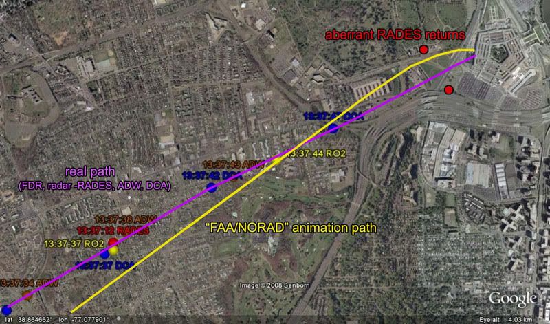
Analysis of the recently-released NORAD-made animation of Flight 77's final approach, which, like the earlier NTSB cartoon, shows the plane flying North of the Citgo, which is wrong. This time, they also have it banking hard right over the navy Annex like Citizen investigation Team argue... and it was made in 2002, from radar records it seems. Again, I've located the likely technical reason for this error, if not the original intent.
For an intro to this recreation, please see my previous post on the subject, which incorrectly attributed it to the FAA.
Additional Notes: Forthcoming.
Showing posts with label radar. Show all posts
Showing posts with label radar. Show all posts
Wednesday, October 8, 2008
Saturday, September 13, 2008
FAA? WTF?
FAA'S NoC ANIMATION
first posting Sept 13 2008, 12 am
Last update 10/8 2am
So, John Farmer is, I guess, back from Arlington and has received reams of new data, this time from the FAA. He alerted Arabesque and I via e-mail.
I get a lot of these from him and don't even usually keep up. But the second e-mail here, about the included animation, made me sit up and take notice.
It shows, more or less, CIT's concocted path over the Navy Annex, with a hard hard right bank/turn and a passage north of the citgo, followed by low level impact (higher only to allow the right wing). I have just been in the middle of laying out the overabundance of North-path clues (there should be roughly nil), including the NTSB's earlier animation to similar effect, so this was doubly ironic as it hit me. This is so insane, the easiest explanation I can think of is... Farmer's pulling my leg?
Two stills, with real and CIT paths (quite app) in the usual colors overlaid. These are from the Youtube version, but Farmer made a higher resolution version available for download and viewing.


---first thoughts, unedited
Any thoughts, people? All I can think of is what - the - fuck?
Or, wait... mmmaybe FAA based it on radar and/or FDR up to the end of that data (the loop and all looks fine on first glance) and then stupidly tried to fuse in the NTSB's apparent final moments, hoping they had some reason for putting it on that path for the seconds they were missing (I'd guess 6-10?) ... Just mysteries. This is going to turn out interestingly.
---
Further Developments
Discussion on this took off all over with the expected rapidity, but a more dynamic embrace than some expected.
CIT Forum discussion Craig and Aldo, who seethe with venom against Farmer, and aren't 'taking the bait' as it were. They speak of "chess moves" and such... Very sophisticated over there, their apprehension and ruminations! On the other hand, many like Rob Balsamo at the PfffT forum were giggling with excitement, while CIT strongly advised caution, leading to a curious argument about which dishonest track to take. CIT messenger Domenick DiMaggio (aka Terrocell, TC329) also started a JREF discussion thread about it, stating at one point:
Whatwhatwhat? Nonetheless, this is where things took off with both confusion and learning. First, beyond disseminating it, the FAA seem to have no role in this short video. JREF member Gumboot first questioned their authenticity and/or their relevance, but over the first couple pages identified the logos onscreen (www.stk.com and HQ NORAD/USSPACE/AN), and found STK was the Satellite Tool Kit Radar module, marketed by Analytical Graphics, Inc. (AGI), a company that makes software for "national security and space professionals for integrated analysis of land, sea, air, and space assets." He noted "the big golf ball things" seemed to be FAA Long Range Radar sites, and decided this may well be "a radar-based map for NORAD purposes," possibly "to determine which radar sites AA77 passed through, so that 84th RADES knew which data to collect for their analysis." Definitely getting somewhere.
Radar based... north path... I would have figure it out eventually, but Celestrin beat me to it. No wonder CIT were apprehensive - they knew about the false return placed for whatever reason, just north of the Citgo, and I had to point out that it wasn't their north path plane, at least 1,000 feet to low for radar to see. Celestrin made the connect:
I looked at it a bit the other night and did some graphic comparisons just to see what patterns popped out. I took the peach map from the NTSB's Flight Path Study and set the final map of the animation over it [below]. Note the apparent offset in rotation and location of the loop cross point. I'm not actually sure if the whole path is rotated, or this is just a local distortion from roughness. It is rough and unrealistic in its movements. Farmer instantly pointed out "Look at the loop you idiots, it is a square with rounded corners!" I noticed this too, as did Celestrin. The "squarish" appearance of the turn manuever also suggests that the data, which was used in the animation, wasn't continous." Given 12-second intervals between returns is "too fine for the animation," he wondered "what if one takes the RADES data 1 minute apart," or every fifth radar return, and got this.
When I marked the spots where straight lines start curving, and overlaid it with the 84 RADES returns for the loop, it looks more like this was based on taking every other 84 RADES return (pink dots) as anchor points, and replaced the intervening ones with straight lines or full curves, depending.


This in turn may be a clue to the north path’s appearance. Consider this pattern in light of these final three points of RADES data (the points stupidly connected above]. There may be a different dynamic at play here, but it seems similar in pattern – draw a straight line to, or near, the north point, and then a sharp curve to try and meet, or orbit, the next aberrant return just south of impact. Considering there may be a rotation of the path relative to the map, or vice-versa, and perhaps a slight spatial offset, the actual mapped curve may not be where it looks to be onscreen. Interestingly, when I rotate the line to fit the real path, the turn is about seven degrees, or the amount the NTSB's final map was rotated from its own lat-long grid. [Propos to Farmer for the background image establishing the real path beyond a reasonable doubt]. This is not my final answer, but I'm pretty sure it's close to correct, or on the right track at least.


---
More on the source
Pilots for 911 Truth forum member "Paranoia" looked at AGI's STK.com website and found some interesting information verifying Gumboot's ID. [link]. Of interest is a winter 2002 presentation by AGI President and CEO Paul Graziani, regarding their 9/11 animations. The accompanying powerpoint presentation confirms he's discussing this very simulation - it's pictured on page 5. In his delivered remarks [PDF link ], Graziani explained to assembled conventioneers how "actual FAA radar data was used to accurately recreate the events and model the flight paths of hijacked airlines as well as the responding military aircraft." Actual data, it would seem so. Accurate, only sorta... Of interest is the line "complex problems that once took weeks or months to complete, now take only seconds or minutes when employing software capabilities." Maybe they should have at least spent hours on this one.
Additional update: Just to clarify, this is a NORAD product, not FAA. This powerpoint presentation, from a June 2002 STK users conference, explains the project a little. It covered all four flights, plus responding fighters, all from FAA-supplied radar data.
---
The Video: I refined slightly the final returns angle, and put it together in video form, viewable with notes here.
first posting Sept 13 2008, 12 am
Last update 10/8 2am
So, John Farmer is, I guess, back from Arlington and has received reams of new data, this time from the FAA. He alerted Arabesque and I via e-mail.
The FAA has sent me via certified mail all of the records I requested in my Court action. It is going to take the entire weekend to go through it all, but it looks like the ATC audio and radar records for 1332 – 1344 for Washington ARTCC, Dulles, Reagan, Andrews and Baltimore.
If this turns out to be everything I think it is, then CIT is going to be squirming a little more.
I get a lot of these from him and don't even usually keep up. But the second e-mail here, about the included animation, made me sit up and take notice.
I attempted to send you guys the whole video, but it was too big for some mailboxes. You are the first to see this (I hope) and you just know CIT and Rob are gonna love it!
http://www.youtube.com/watch?v=DQsyt_7c1H8
It shows, more or less, CIT's concocted path over the Navy Annex, with a hard hard right bank/turn and a passage north of the citgo, followed by low level impact (higher only to allow the right wing). I have just been in the middle of laying out the overabundance of North-path clues (there should be roughly nil), including the NTSB's earlier animation to similar effect, so this was doubly ironic as it hit me. This is so insane, the easiest explanation I can think of is... Farmer's pulling my leg?
Two stills, with real and CIT paths (quite app) in the usual colors overlaid. These are from the Youtube version, but Farmer made a higher resolution version available for download and viewing.
---first thoughts, unedited
Any thoughts, people? All I can think of is what - the - fuck?
Or, wait... mmmaybe FAA based it on radar and/or FDR up to the end of that data (the loop and all looks fine on first glance) and then stupidly tried to fuse in the NTSB's apparent final moments, hoping they had some reason for putting it on that path for the seconds they were missing (I'd guess 6-10?) ... Just mysteries. This is going to turn out interestingly.
---
Further Developments
Discussion on this took off all over with the expected rapidity, but a more dynamic embrace than some expected.
CIT Forum discussion Craig and Aldo, who seethe with venom against Farmer, and aren't 'taking the bait' as it were. They speak of "chess moves" and such... Very sophisticated over there, their apprehension and ruminations! On the other hand, many like Rob Balsamo at the PfffT forum were giggling with excitement, while CIT strongly advised caution, leading to a curious argument about which dishonest track to take. CIT messenger Domenick DiMaggio (aka Terrocell, TC329) also started a JREF discussion thread about it, stating at one point:
they faked it and now they're releasing fake evidence to corroborate cit's evidence and yet still try to prove an impact. and as soon as you guys put the cats down and erase lloyd from the history books they can get away with their evil plans.
Whatwhatwhat? Nonetheless, this is where things took off with both confusion and learning. First, beyond disseminating it, the FAA seem to have no role in this short video. JREF member Gumboot first questioned their authenticity and/or their relevance, but over the first couple pages identified the logos onscreen (www.stk.com and HQ NORAD/USSPACE/AN), and found STK was the Satellite Tool Kit Radar module, marketed by Analytical Graphics, Inc. (AGI), a company that makes software for "national security and space professionals for integrated analysis of land, sea, air, and space assets." He noted "the big golf ball things" seemed to be FAA Long Range Radar sites, and decided this may well be "a radar-based map for NORAD purposes," possibly "to determine which radar sites AA77 passed through, so that 84th RADES knew which data to collect for their analysis." Definitely getting somewhere.
Radar based... north path... I would have figure it out eventually, but Celestrin beat me to it. No wonder CIT were apprehensive - they knew about the false return placed for whatever reason, just north of the Citgo, and I had to point out that it wasn't their north path plane, at least 1,000 feet to low for radar to see. Celestrin made the connect:
RADES data has been available for months and it shows the exact same North of Cthulhu poperties as this animation. [...] Why is it such a wonder that an animation, which most likely uses the same data, would also show the plane further north?
I looked at it a bit the other night and did some graphic comparisons just to see what patterns popped out. I took the peach map from the NTSB's Flight Path Study and set the final map of the animation over it [below]. Note the apparent offset in rotation and location of the loop cross point. I'm not actually sure if the whole path is rotated, or this is just a local distortion from roughness. It is rough and unrealistic in its movements.
 Farmer instantly pointed out "Look at the loop you idiots, it is a square with rounded corners!" I noticed this too, as did Celestrin. The "squarish" appearance of the turn manuever also suggests that the data, which was used in the animation, wasn't continous." Given 12-second intervals between returns is "too fine for the animation," he wondered "what if one takes the RADES data 1 minute apart," or every fifth radar return, and got this.
When I marked the spots where straight lines start curving, and overlaid it with the 84 RADES returns for the loop, it looks more like this was based on taking every other 84 RADES return (pink dots) as anchor points, and replaced the intervening ones with straight lines or full curves, depending.

This in turn may be a clue to the north path’s appearance. Consider this pattern in light of these final three points of RADES data (the points stupidly connected above]. There may be a different dynamic at play here, but it seems similar in pattern – draw a straight line to, or near, the north point, and then a sharp curve to try and meet, or orbit, the next aberrant return just south of impact. Considering there may be a rotation of the path relative to the map, or vice-versa, and perhaps a slight spatial offset, the actual mapped curve may not be where it looks to be onscreen. Interestingly, when I rotate the line to fit the real path, the turn is about seven degrees, or the amount the NTSB's final map was rotated from its own lat-long grid. [Propos to Farmer for the background image establishing the real path beyond a reasonable doubt]. This is not my final answer, but I'm pretty sure it's close to correct, or on the right track at least.

---
More on the source
Pilots for 911 Truth forum member "Paranoia" looked at AGI's STK.com website and found some interesting information verifying Gumboot's ID. [link]. Of interest is a winter 2002 presentation by AGI President and CEO Paul Graziani, regarding their 9/11 animations. The accompanying powerpoint presentation confirms he's discussing this very simulation - it's pictured on page 5. In his delivered remarks [PDF link ], Graziani explained to assembled conventioneers how "actual FAA radar data was used to accurately recreate the events and model the flight paths of hijacked airlines as well as the responding military aircraft." Actual data, it would seem so. Accurate, only sorta... Of interest is the line "complex problems that once took weeks or months to complete, now take only seconds or minutes when employing software capabilities." Maybe they should have at least spent hours on this one.
Additional update: Just to clarify, this is a NORAD product, not FAA. This powerpoint presentation, from a June 2002 STK users conference, explains the project a little. It covered all four flights, plus responding fighters, all from FAA-supplied radar data.
---
The Video: I refined slightly the final returns angle, and put it together in video form, viewable with notes here.
Friday, August 8, 2008
OVERWHELMING EVIDENCE FOR 9:38
PENTAGON ATTACK TIMELINE QUESTIONS PART 3: OVERWHELMING EVIDENCE FOR 9:38
Adam Larson / Caustic Logic
The Frustrating Fraud
August 7 2008
Last Updated 8/10/09
For those who see no reason to question the official time of the Pentagon attack, this post will be unnecessary. But for those confused by claims of different times, primarily 9:30-32 am, this may prove quite useful. If you're willing to learn... (sigh). Of all the times cited for the impact/explosion/whatever at the Pentagon on 9/11, one stands above as the most-cited, most-supported, and most-likely true – by this I mean, approximately, 9:38 am. Officially the explosive impact of Flight 77 is given as 9:37:45 or :46 based, it seems, on the Flight Data Recorder. In reality, the impact time is impossible to pin down exactly, but likely a bit after this, probably between 9:37:50 and :55 (see FDR section, first up). Following is a nearly-comprehensive list of the most direct evidence establishing the impact at right around that time.
1) Flight Data Recorder:
Much rhubarb has been made of the information on Flight 77’s Flight Data Recorder and how it doesn’t match the reality necessary to get it inside the Pentagon where it was said to be found. The last frame of data recorded is 9:37:44 or :45, depending on the exact file one’s looking at. While this is officially the moment of impact, the recorded values do not match those evident in the physical damage (most important – too high!) This is taken by some nitwits/liars as proof the plane didn’t hit. Another view takes this as a clue that this last data is actually NOT from the moment of impact, but a mile or more back, as the INS positioning says (it’s prone to error of about 1/2 mile I hear). Most analysts have come to this realization, though opinions differ on how far back, how much data is missing, and why (which is beyond the scope of this piece). Estimates range from 2 to 10 seconds remaining to impact at last frame, with the upper end of 8-10 seeming most likely to me, and placing impact at 9:37:50 or later. This slight variation of the “official” time alternates with it in the list below and illustrate that roughly all evidence points at a roughly 10 second time range best rounded to the minute as 9:38.
 2) Radar:
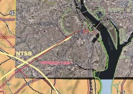
We’ve always heard the radar data supported and defined this impact time, but fact is it can’t tell us exactly when, or even if, the plane impacted. The raw data of the Air Force’s 84th radar evaluation squadron (84RADES) was released in 2006 to researcher John Farmer, showing all returns from the DC area on 9/11. As I understand it, ‘blips’ are sent and returned every 12 seconds; the last three attributed to Flight 77 are at 9:36:48, 9:37:00, and 9:37:12 (see graphic at right, from Marco Bolletino’s reconstruction of the data). Before the next return, the airliner dropped below the coverage level of app.2,000 feet above ground [this altitude is passed by FDR about 9:37:18]. There is an established NEADS clock issue, known to be app. 25 seconds slow relative to other clocks in the FDR and at ATC facilities. Therefore, the last return would actually be at about 9:37:37, with impact presumably some seconds after that. This support is vague but would hint at an impact somewhat later than the official time less than ten seconds hence. On the other hand, the FDR pressure alt for 9:37:37 is 786 ft AGL, which seems too low to be just disappearing from radar. Perhaps I’m confused on the timeline discrepancy. Anyway, it’s all there… it doesn’t prove a 9:38 impact, but it fits it just fine.
1a+2a) FDR/Radar Combo:
In its Final Report, the 9/11 Commission gives the impact time of 9:37:46 [p 96], citing as its source NTSB report, "Flight Path Study-American Airlines Flight 77," created Feb. 19, 2002 by the National Transportation Safety Board. The full document in question is available in PDF form [here. The report in turn lists its sources as FDR data “as well as” (implying no conflict with) “radar data from the Federal Aviation Administration’s Air Route Traffic Control Centers, approach control at Washington Dulles Airport, and the U.S. Air Force’s 84th Radar Evaluation Squadron.” [This is the data examined above]. From this, the report summarizes that “the airplane accelerated to approximately 460 knots (530 miles per hour) at impact with the Pentagon. The time of impact was 9:37:45 AM.” Ooh! A one-second discrepancy! And both were likely a bit early, with the Commission closer it seems.
3) Arlington County Emergency System:
From Arlington County After-Action Report, and its first-hand access to emergency communications , we can see that key information was called in just before and after the 9:38 mark, and reactions followed in the next minutes, as recorded and logged as at a time generalized as 9:38. [emph mine].
“In the moments immediately before impact at the Pentagon, the Arlington County ECC began receiving 9-1-1 calls reporting a low flying airliner that seemed off the normal flight path. When the crash actually occurred at 9:38 a.m., all area communications seemed simultaneously overwhelmed. Firefighters calling the ECC couldn’t get through. Relatives of Pentagon workers found cellular and land lines jammed. Emergency traffic flooded radio channels.” [page A-34]
“Captain Steve McCoy and the crew of Engine 101 were […] traveling north on Interstate 395 [when they saw] a commercial airliner in steep descent, banking sharply to its right before disappearing beyond the horizon. At 9:38 a.m., shortly after American Airlines Flight #77 disappeared from sight, a tremendous explosion preceded a massive plume of smoke and fire. Unable to pinpoint the precise location, Captain McCoy immediately radioed the Arlington County Emergency Communications Center (ECC), reporting an airplane crash in the vicinity of the 14th Street Bridge or in Crystal City.” [page A-34]
At 9:38 a.m., a large smoke plume appeared beyond the Rosslyn skyline. Arlington County Police Corporal Barry Foust radioed the ECC that he saw an American Airlines jet crash into the Pentagon. The ECC swung into action [page A-35] […] [B]etween 9:41 a.m. and 9:43 a.m. on September 11, the ECC Administrator, Steve Souder, acting on his own initiative, contacted the Fairfax, Alexandria, and District of Columbia fire departments. He gave them identical instructions: deploy four engines, two trucks, one rescue unit, four EMS units, and a command officer to a staging area short of the Pentagon and hold them there until called forward.” [page a25]
4) C130 pilot report via FAA:
The 9/11 Commission briefly discussed the “second plane” at the Pentagon, a C-130H cargo plane dubbed “Golfer 06.” The Commission noted on page 26 of their final report:
“At approximately 9:38 A.M., the C130H aircraft reported to Reagan Airport controllers that the aircraft it was attempting to follow crashed into the Pentagon.” The source is given as “FAA audio file, Washington Tower, Tyson/Fluky Position, 9:38:52 .-M.; FAA letterhead memorandum, 'Partial Transcript; Aircraft Accident; AAL 77; Washington, DC; September 11, 2001,’ 7.
Although the two planes had crossed path just a minute before, both radar and the pilot’s own words agree that Golfer 06 was too far away to see Flight 77 itself at impact, but was close enough to see the smoke and to know where it was coming from. Certainly the impression was there from the beginning, and was only confirmed as it approached at 9:38, passing nearest to impact point at 9:39:15, after which it veered off to the north and west and continued on to witness the crash site of Flight 93 as well before reaching base in Minnesota.
5) 9:39 News Report - NBC:
Among the most solid clues to at least the general time of the attack of the Pentagon attack is in NBC News coverage of the 9/11 events. [video link - when watching the video, note that it starts at 9:12 am, so the video time is to be added to this for the real time] At perhaps 10 seconds after the 9:39 mark [26:24 video time], the newsroom interrupted its coverage to let Pentagon correspondent Jim Miklaszewski bring them their first news of something awry there. He told the nation:
"I don’t want to alarm anybody right now, but apparently - it felt, just a few moments ago, like there was an explosion of some kind, here at the Pentagon.” He explains he was on the east side of the mammoth building, opposite from the impact, so it was a big explosion. He saw no smoke from his side, inside the E ring, and didn’t know what was going on. “I just stepped out in the hallway, security guards were herding people out," he explained, meaning some time at least had elapsed. So far impact is looking to be one minute, 15 seconds before this broadcast. Sounds like “moments” to me.
6) Security video time stamps – Pentagon, Doubletree, Citgo:
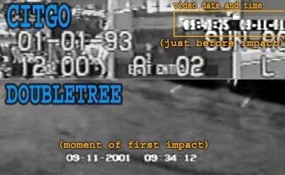
Though neither the Citgo or Doubletree videos, released in 2006, shows the official time in their on-screen clocks, both timers roughly bracket it: Doubletree – 9:34:10 impact (app 3:35 behind) Citgo 9:40:36 (app 2:51 ahead)
It’s a very small sample to be conclusive, but this is what’s called a normal distribution, that sets a center point of app. 9:37:00. That’s pretty close for a sampling of two clocks, one of which also bears the default date of Jan 1 1993 [for a clue to the professionalism and precision of their deployment].
Regarding the time stamp of the Pentagon’s own CCTV gate cameras that famously captured the plane and impact, Col. Alan Scott told the 9/11 Commission in May 2003:
“The timeline on the impact of the Pentagon was changed to 9:37 -- 9:43 is the time that was reported that day, it was the time we used. And it took about two weeks to discover in the parking lot of the Pentagon this entry camera for the parking lot, which happened to be oriented towards the Pentagon at the time of impact, and the recorded time is 9:37. And that's why the timeline went from 9:43 to 9:37, because it is the best documented evidence for the impact time that we have.” [source]
It should be noted that the time stamp is not reproduced on-screen. The initial five released framed show a time of the following evening Sept 12 – much to the delight of mystery-mongers, it’s more likely the time the frames were processed and labeled “plane,” “impact,” etc… but they seem to have been recorded in the 9:37 slot on the correct day, and were in fact instrumental in setting the time initially. We find later it’s actually near the end of that minute, but still technically not 9:38.
7) Eyewitnesses:
Considering the known unreliability of eyewitness recollection, and that most people do not directly time-stamp their memories, it should not be surprising that this sector of the evidence is the least clear on the actual impact moment. Just a few of the published accounts provide useful clues, while many specifically disagree or are hopelessly vague. The oft-cited “9:30” is too common a rounding point to be taken too seriously, and it appears several times. A small sampling that are said to specifically cite something more like 9:32 were outlined in a previous post. But the sampling of five below does establish a normal distribution around the minute all other evidence is pointing at.
“It was about 9:35 […] it came from the south. […] I watched it come in very low over the trees and it just dipped down came down right over 395 into the Pentagon.” – Don Wright
“At 9:40 a.m. I was driving down Washington Boulevard (Route 27) along the side of the Pentagon when the aircraft crossed about 200 yards… in front of me.” - Donald R. Bouchoux
“At 9:35 a.m., I pulled alongside the Pentagon. With traffic at a standstill, my eyes wandered around the road, looking for the cause of the traffic jam. Then I looked up to my left and saw an American Airlines jet flying right at me.” - Vin Narayanan
“At 9:35, as we were watching this on TV, we heard over the loudspeaker “All medical personnel report to the front desk of Medical.” We did not know at that time that the Pentagon had been hit.” - Captain William B. Durm
“About 9:30 or so — I don't know the exact time, maybe quarter to 10 — we were still in the conference room, and we heard and felt the loud explosion of the plane hitting the Pentagon, and it reminded me of an earthquake.” – Lt. Col. Frank Bryceland [note: the mid-point of the range from 9:30-45 is 9:37:30.]
Update:As the brilliant JREF member Mangoose pointed out to me a while back:
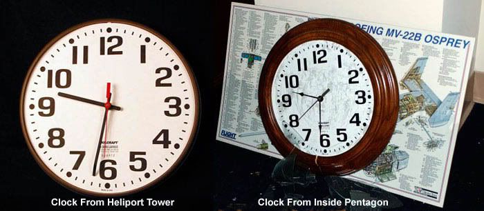
8) Wall clocks at the Pentagon:
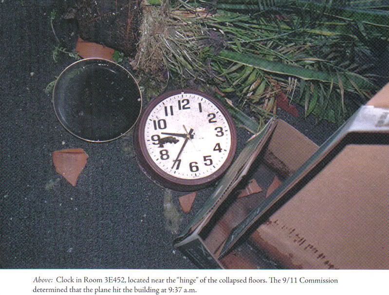
In the Book Pentagon 9/11 [Goldberg, 2007] is pictured a wall clock from an office above the impact area, stopped at 9:36:27 – one minute, 25 sec behind the time in discussion. This is reasonably close and solid evidence of the general time at least.
Ironically enough, the famous 9:30-ish stopped clocks, which stand as the best (basically only) evidence for a blast at that early time, may also support the 9:38 time-frame. Non-nutty 9/11 Truther Russell Pickering decided that the low time is a case broken mechanisms as the clocks hit bottom-first after falling from their mounts, with simple gravity responsible for pulling the hands down to near bottom. He issued a challenge for anyone to take, which no 9:32 event supporters did, For one, CIT ally Mirage of Deceit (nutty) later confirmed the results (link unavailable). The pictures indicate the minute hands were somewhere past the 6, not before, but little else can be said for sure. But since everything else says it all went down at 9:38, is it not reasonable to call these a double-confirmation of that time with gravity rounding it down towards 9:30? [note: although it seems to have fallen differently and onto carpet, a similar effect could be behind the above clock’s being behind – or perhaps someone at the Pentagon actually was synched over a minute behind.]
Case Closed
So now that the 9:38 case looks strong enough to actually absorb even the best early-attack evidence, I’d like to turn to some assorted other evidence that doesn’t fit, and for shits and giggles use it to craft smtig even stupider than the 9:32 Pentagon attack meme (which CIT doesn’t even buy). Who knows, some bold Truther might just run with the 9:30-or-before scenario (oops, they already have) or the 9:25 WTC attack (no takers yet).
Adam Larson / Caustic Logic
The Frustrating Fraud
August 7 2008
Last Updated 8/10/09
For those who see no reason to question the official time of the Pentagon attack, this post will be unnecessary. But for those confused by claims of different times, primarily 9:30-32 am, this may prove quite useful. If you're willing to learn... (sigh). Of all the times cited for the impact/explosion/whatever at the Pentagon on 9/11, one stands above as the most-cited, most-supported, and most-likely true – by this I mean, approximately, 9:38 am. Officially the explosive impact of Flight 77 is given as 9:37:45 or :46 based, it seems, on the Flight Data Recorder. In reality, the impact time is impossible to pin down exactly, but likely a bit after this, probably between 9:37:50 and :55 (see FDR section, first up). Following is a nearly-comprehensive list of the most direct evidence establishing the impact at right around that time.
1) Flight Data Recorder:
Much rhubarb has been made of the information on Flight 77’s Flight Data Recorder and how it doesn’t match the reality necessary to get it inside the Pentagon where it was said to be found. The last frame of data recorded is 9:37:44 or :45, depending on the exact file one’s looking at. While this is officially the moment of impact, the recorded values do not match those evident in the physical damage (most important – too high!) This is taken by some nitwits/liars as proof the plane didn’t hit. Another view takes this as a clue that this last data is actually NOT from the moment of impact, but a mile or more back, as the INS positioning says (it’s prone to error of about 1/2 mile I hear). Most analysts have come to this realization, though opinions differ on how far back, how much data is missing, and why (which is beyond the scope of this piece). Estimates range from 2 to 10 seconds remaining to impact at last frame, with the upper end of 8-10 seeming most likely to me, and placing impact at 9:37:50 or later. This slight variation of the “official” time alternates with it in the list below and illustrate that roughly all evidence points at a roughly 10 second time range best rounded to the minute as 9:38.
 2) Radar:
 We’ve always heard the radar data supported and defined this impact time, but fact is it can’t tell us exactly when, or even if, the plane impacted. The raw data of the Air Force’s 84th radar evaluation squadron (84RADES) was released in 2006 to researcher John Farmer, showing all returns from the DC area on 9/11. As I understand it, ‘blips’ are sent and returned every 12 seconds; the last three attributed to Flight 77 are at 9:36:48, 9:37:00, and 9:37:12 (see graphic at right, from Marco Bolletino’s reconstruction of the data). Before the next return, the airliner dropped below the coverage level of app.2,000 feet above ground [this altitude is passed by FDR about 9:37:18]. There is an established NEADS clock issue, known to be app. 25 seconds slow relative to other clocks in the FDR and at ATC facilities. Therefore, the last return would actually be at about 9:37:37, with impact presumably some seconds after that. This support is vague but would hint at an impact somewhat later than the official time less than ten seconds hence. On the other hand, the FDR pressure alt for 9:37:37 is 786 ft AGL, which seems too low to be just disappearing from radar. Perhaps I’m confused on the timeline discrepancy. Anyway, it’s all there… it doesn’t prove a 9:38 impact, but it fits it just fine.
1a+2a) FDR/Radar Combo:
In its Final Report, the 9/11 Commission gives the impact time of 9:37:46 [p 96], citing as its source NTSB report, "Flight Path Study-American Airlines Flight 77," created Feb. 19, 2002 by the National Transportation Safety Board. The full document in question is available in PDF form [here. The report in turn lists its sources as FDR data “as well as” (implying no conflict with) “radar data from the Federal Aviation Administration’s Air Route Traffic Control Centers, approach control at Washington Dulles Airport, and the U.S. Air Force’s 84th Radar Evaluation Squadron.” [This is the data examined above]. From this, the report summarizes that “the airplane accelerated to approximately 460 knots (530 miles per hour) at impact with the Pentagon. The time of impact was 9:37:45 AM.” Ooh! A one-second discrepancy! And both were likely a bit early, with the Commission closer it seems.
3) Arlington County Emergency System:
From Arlington County After-Action Report, and its first-hand access to emergency communications , we can see that key information was called in just before and after the 9:38 mark, and reactions followed in the next minutes, as recorded and logged as at a time generalized as 9:38. [emph mine].
“In the moments immediately before impact at the Pentagon, the Arlington County ECC began receiving 9-1-1 calls reporting a low flying airliner that seemed off the normal flight path. When the crash actually occurred at 9:38 a.m., all area communications seemed simultaneously overwhelmed. Firefighters calling the ECC couldn’t get through. Relatives of Pentagon workers found cellular and land lines jammed. Emergency traffic flooded radio channels.” [page A-34]
“Captain Steve McCoy and the crew of Engine 101 were […] traveling north on Interstate 395 [when they saw] a commercial airliner in steep descent, banking sharply to its right before disappearing beyond the horizon. At 9:38 a.m., shortly after American Airlines Flight #77 disappeared from sight, a tremendous explosion preceded a massive plume of smoke and fire. Unable to pinpoint the precise location, Captain McCoy immediately radioed the Arlington County Emergency Communications Center (ECC), reporting an airplane crash in the vicinity of the 14th Street Bridge or in Crystal City.” [page A-34]
At 9:38 a.m., a large smoke plume appeared beyond the Rosslyn skyline. Arlington County Police Corporal Barry Foust radioed the ECC that he saw an American Airlines jet crash into the Pentagon. The ECC swung into action [page A-35] […] [B]etween 9:41 a.m. and 9:43 a.m. on September 11, the ECC Administrator, Steve Souder, acting on his own initiative, contacted the Fairfax, Alexandria, and District of Columbia fire departments. He gave them identical instructions: deploy four engines, two trucks, one rescue unit, four EMS units, and a command officer to a staging area short of the Pentagon and hold them there until called forward.” [page a25]
4) C130 pilot report via FAA:
The 9/11 Commission briefly discussed the “second plane” at the Pentagon, a C-130H cargo plane dubbed “Golfer 06.” The Commission noted on page 26 of their final report:
“At approximately 9:38 A.M., the C130H aircraft reported to Reagan Airport controllers that the aircraft it was attempting to follow crashed into the Pentagon.” The source is given as “FAA audio file, Washington Tower, Tyson/Fluky Position, 9:38:52 .-M.; FAA letterhead memorandum, 'Partial Transcript; Aircraft Accident; AAL 77; Washington, DC; September 11, 2001,’ 7.
Although the two planes had crossed path just a minute before, both radar and the pilot’s own words agree that Golfer 06 was too far away to see Flight 77 itself at impact, but was close enough to see the smoke and to know where it was coming from. Certainly the impression was there from the beginning, and was only confirmed as it approached at 9:38, passing nearest to impact point at 9:39:15, after which it veered off to the north and west and continued on to witness the crash site of Flight 93 as well before reaching base in Minnesota.
5) 9:39 News Report - NBC:
Among the most solid clues to at least the general time of the attack of the Pentagon attack is in NBC News coverage of the 9/11 events. [video link - when watching the video, note that it starts at 9:12 am, so the video time is to be added to this for the real time] At perhaps 10 seconds after the 9:39 mark [26:24 video time], the newsroom interrupted its coverage to let Pentagon correspondent Jim Miklaszewski bring them their first news of something awry there. He told the nation:
"I don’t want to alarm anybody right now, but apparently - it felt, just a few moments ago, like there was an explosion of some kind, here at the Pentagon.” He explains he was on the east side of the mammoth building, opposite from the impact, so it was a big explosion. He saw no smoke from his side, inside the E ring, and didn’t know what was going on. “I just stepped out in the hallway, security guards were herding people out," he explained, meaning some time at least had elapsed. So far impact is looking to be one minute, 15 seconds before this broadcast. Sounds like “moments” to me.
6) Security video time stamps – Pentagon, Doubletree, Citgo:
Though neither the Citgo or Doubletree videos, released in 2006, shows the official time in their on-screen clocks, both timers roughly bracket it: Doubletree – 9:34:10 impact (app 3:35 behind) Citgo 9:40:36 (app 2:51 ahead)
It’s a very small sample to be conclusive, but this is what’s called a normal distribution, that sets a center point of app. 9:37:00. That’s pretty close for a sampling of two clocks, one of which also bears the default date of Jan 1 1993 [for a clue to the professionalism and precision of their deployment].
Regarding the time stamp of the Pentagon’s own CCTV gate cameras that famously captured the plane and impact, Col. Alan Scott told the 9/11 Commission in May 2003:
“The timeline on the impact of the Pentagon was changed to 9:37 -- 9:43 is the time that was reported that day, it was the time we used. And it took about two weeks to discover in the parking lot of the Pentagon this entry camera for the parking lot, which happened to be oriented towards the Pentagon at the time of impact, and the recorded time is 9:37. And that's why the timeline went from 9:43 to 9:37, because it is the best documented evidence for the impact time that we have.” [source]
It should be noted that the time stamp is not reproduced on-screen. The initial five released framed show a time of the following evening Sept 12 – much to the delight of mystery-mongers, it’s more likely the time the frames were processed and labeled “plane,” “impact,” etc… but they seem to have been recorded in the 9:37 slot on the correct day, and were in fact instrumental in setting the time initially. We find later it’s actually near the end of that minute, but still technically not 9:38.
7) Eyewitnesses:
Considering the known unreliability of eyewitness recollection, and that most people do not directly time-stamp their memories, it should not be surprising that this sector of the evidence is the least clear on the actual impact moment. Just a few of the published accounts provide useful clues, while many specifically disagree or are hopelessly vague. The oft-cited “9:30” is too common a rounding point to be taken too seriously, and it appears several times. A small sampling that are said to specifically cite something more like 9:32 were outlined in a previous post. But the sampling of five below does establish a normal distribution around the minute all other evidence is pointing at.
“It was about 9:35 […] it came from the south. […] I watched it come in very low over the trees and it just dipped down came down right over 395 into the Pentagon.” – Don Wright
“At 9:40 a.m. I was driving down Washington Boulevard (Route 27) along the side of the Pentagon when the aircraft crossed about 200 yards… in front of me.” - Donald R. Bouchoux
“At 9:35 a.m., I pulled alongside the Pentagon. With traffic at a standstill, my eyes wandered around the road, looking for the cause of the traffic jam. Then I looked up to my left and saw an American Airlines jet flying right at me.” - Vin Narayanan
“At 9:35, as we were watching this on TV, we heard over the loudspeaker “All medical personnel report to the front desk of Medical.” We did not know at that time that the Pentagon had been hit.” - Captain William B. Durm
“About 9:30 or so — I don't know the exact time, maybe quarter to 10 — we were still in the conference room, and we heard and felt the loud explosion of the plane hitting the Pentagon, and it reminded me of an earthquake.” – Lt. Col. Frank Bryceland [note: the mid-point of the range from 9:30-45 is 9:37:30.]
Update:As the brilliant JREF member Mangoose pointed out to me a while back:
I would also draw your attention to the witness account of William Paisley who posts as Pinch at JREF and who has a blog http://www.instapinch.com/.
You might want to contact him directly but he has elsewhere related that he was at Crystal Park 3, 10th floor on 9/11, and was watching NBC coverage of the terrorist attacks; when he saw Jim Miklaszewki's report at 9:39:10 he took a few steps to his office window and immediately saw a billowing, building mushroom cloud of black smoke rising up above the roofs of the buildings between his building and the Pentagon. This is pretty good confirmation that the explosion was not too much sooner than 9:39.
8) Wall clocks at the Pentagon:
In the Book Pentagon 9/11 [Goldberg, 2007] is pictured a wall clock from an office above the impact area, stopped at 9:36:27 – one minute, 25 sec behind the time in discussion. This is reasonably close and solid evidence of the general time at least.
Ironically enough, the famous 9:30-ish stopped clocks, which stand as the best (basically only) evidence for a blast at that early time, may also support the 9:38 time-frame. Non-nutty 9/11 Truther Russell Pickering decided that the low time is a case broken mechanisms as the clocks hit bottom-first after falling from their mounts, with simple gravity responsible for pulling the hands down to near bottom. He issued a challenge for anyone to take, which no 9:32 event supporters did, For one, CIT ally Mirage of Deceit (nutty) later confirmed the results (link unavailable). The pictures indicate the minute hands were somewhere past the 6, not before, but little else can be said for sure. But since everything else says it all went down at 9:38, is it not reasonable to call these a double-confirmation of that time with gravity rounding it down towards 9:30? [note: although it seems to have fallen differently and onto carpet, a similar effect could be behind the above clock’s being behind – or perhaps someone at the Pentagon actually was synched over a minute behind.]
Case Closed
So now that the 9:38 case looks strong enough to actually absorb even the best early-attack evidence, I’d like to turn to some assorted other evidence that doesn’t fit, and for shits and giggles use it to craft smtig even stupider than the 9:32 Pentagon attack meme (which CIT doesn’t even buy). Who knows, some bold Truther might just run with the 9:30-or-before scenario (oops, they already have) or the 9:25 WTC attack (no takers yet).
Monday, July 21, 2008
LOSING FLIGHT 77
July 21
The official accounts of radar/transponder tracking and communications problems with following Flight 77 tried to explain how the weaponized airliner was allowed to get within a few minutes of its target undetected. In total this has been taken by many (including myself) as an impossible or at least suspicious string of errors, allowing a third successful attack one hour into the new war. The Pentagon WAS protected by a mobile air-to-air missile defnse system, or was supposed to be, and the system failed as fighters were first alerted of the danger by a columnar smoke signal saying mission failed.
A useful new entry at 911 Myths regarding this - Losing Flight 77 - is up now to shed some light on it. I haven't really read it yet, this is just a tip-off. Calling on arguments by the relatively respectable and non-loony 9/11 Scholar Nafeez Ahmed, the 9/11 Commission Report and hearings, original interview with Colin Scoggins, and more, Mike W concludes:
Not a single one of Ahmed's arguments entirely withstands scrutiny, then. His most substantial point comes in the differing NORAD timeline, but the problems here are well-known, and Ahmed fails to provide independent confirmation to show that their version of events was correct. What's more, the NORAD tapes (released in full after Ahmed completed his book) contradict their timeline, for example clearly showing that they knew nothing of Flight 77 until after 9:30 on 9/11. And so while Ahmed claims victory, the reality is very different: the balance of evidence continues to support the 9/11 Commission timeline for Flight 77.
Additional discussion at JREF with technical input from Gumboot.
Friday, June 6, 2008
RADAR = VISUAL = SOUTHWEST
RADAR = VISUAL = SOUTHWEST
Adam Larson / Caustic Logic
The Frustrating Fraud
June 6 2008
I could have posted this sooner, but it deserved some careful prep, and I’ve enjoyed CIT’s maneuvers in the interim. Sorry fellas – I did set it like an ambush, but didn’t expect it would actually work so well and so quick.
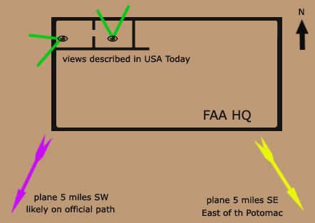
Recently I was able to contact FAA’s Colin Scoggins about his 9/11 report of a plane seen (I presumed) on radar southeast and/or southwest of the White House just prior to the attack. I was thrown for a loop when Scoggins told me it was a visual sighting from FAA HQ in the Capitol, and it seemed he was saying it was therefore NOT a radar report.
That wasn’t even my original question, but I poo-pooed this notion, given the great distance to see it. I did do up some scale experiments that indicated “they certainly would be able to visually pick it out" - barely, as a speck - "if they were first tipped off by, say, a radar report of a plane five miles southeast, er, southwest. But to notice it with no prompting makes little sense to me.”
In the comments at the above link, Craig Ranke of CIT showed his enthusiasm for this revelation and his own idea for the prompting in question:
“So Scoggins is 99% sure it was a visual from FAA HQ in downtown DC! Wow. Great work! Clearly that destroys the NTSB and supports EoP.
[…]
It wouldn't take a "hawkeye" on the DC flight path if they saw it pass their building over DC and kept following it and this does not make any sense AT ALL with the NTSB or alleged radar data!
[…]
>>>>You'd guess they were prompted by the over DC path to keep following it then?
If there is any truth at all to the this visual reference then it is the only explanation. Naturally any plane at all in P56 airspace would alert attention.”
[how about the outbound C-130 over the mall’s south edge? Any witnesses outside the plane?]
Ranke even started a thread at their forum, the last before the valuable threads posted later on “Tramsoccalpra” and “Hydrociault” that were REMOVED! (Censor Nazis ;))
DC flight path - East of Potomac evidence, further confirmed by ATC Colin Scoggins, about how “CIT obsessed Adam Larson did a little investigating of his own and ended up CONFIRMING our claims!” He presented a fuller argument that does make sense given the state of the evidence yesterday, used my graphics, and even linked to the original as a valuable piece of research, if riddled with obfuscation and whatnot. Amazing. Cue the sparkly CIT lyte trip-hop music, this goes in the revised how they forgot to scratch Lloyd's hood and other addenda video...
As far as Ranke’s interpretation that a visual encounter supports the DC flight path, this does make some sense, depending on how much evidence there really is for it being over DC before this (hint – it’s a CIT claim). For CIT it’s a no-brainer since they already believe it was over DC and THIS is what prompted them to follow or project it south, southwest, and so on. But here’s a different, more informed insight, from another Scoggins e-mail just as Craig started posting stuff:
"This [is] taken from the USA Article I mentioned. This is the TELCON I beleive I was on. I am 99% sure. The call came from FAA HQ, and they were on the West side of the FAA HQ building, and Dave Canoles must have been on the North side, so Dave's office was a corner office or it was real close to the corner. "
Cue the record-scratch sound. Indeed. I had heard this article mentioned but hadn't read it, and apparently neither had Ranke. The whole article, from just after 9/11, is still available here. These are the relevant excerpts:
At FAA headquarters, less than a half-mile from the White House and Capitol, Dave Canoles paces before a speakerphone. The head of air traffic investigations, Canoles has set up phone connections with air traffic facilities. […] Now, about 9:35 a.m., he and others on the conference call listen as an official watching a radarscope tracks the progress of the jet heading for Washington
So my either-or impression was a false one based in my ignorance of this piece. Canoles is probably the muted voice we can hear behind Scoggins in the NORAD tapes, and he was first tipped off by another person elsewhere watching the radar track. This makes perfect sense, and then the visual part comes in, prompted by radar. Is there a clue in this to what the returns said?
“Canoles sends an investigator who works for him to an adjoining office with a view to the west. "See if you can spot it," he tells him.
"Six miles from the White House," a voice on the phone says.”
Canoles glances outside, through a window facing north. He wonders if he and his co-workers are in danger. At 500 mph, the jet is traveling a mile every seven seconds.
"Five miles from the White House."
No way the FAA is a target, Canoles thinks. It can't be.
"Four miles from the White House."
They'd never choose to hit us. No way.
"The aircraft is circling. It's turning away from the White House."
Where? Where's it going?
Then: "It's gone."
In the adjoining office, the investigator spots smoke to the west of the city. The jet has hit the Pentagon. The time: 9:38 a.m.”
Scoggins feels this account “flat out tells me that it is visual,” but I don’t really see it. There is talk of windows and attempts to see, which is a hint it might have gone there, but the only thing that’s clearly mentioned actually being seen is the smoke afterwards. Now since the investigator is in an adjoining room a phone bridge seems unnecessary, but it is possible he’s the one on the phone giving the updates based on what he’s seeing out the window. And it’s at least as possible, not knowing more, that these are from the same radar operator that got them started.
It’s not clear from this alone if there was ever a visual sighting of the plane, but Scoggins also heard what Canoles actually said, in the telcon we only hear murmurs of, and he is left 99% certain there was such a contact. I’m inclined at the moment to believe him. So treating this as an eyewitness case, let’s first note that the USA Today piece mentions a view to the north, meaning Canoles’ office was on the building’s north side – he had an investigator go into an adjoining, but different office, with a view to the west – a corner office.
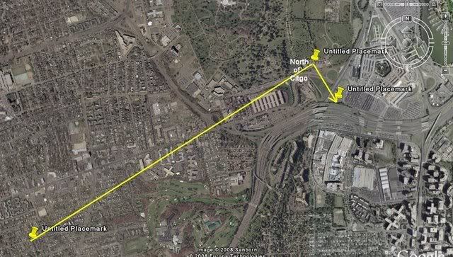
 It’s not clear if any sighting would be before the plane turned fully southward from its original path or after the loop and up to the final approach. The witness would not be able to see the farthest reaches of the loop (darker green, below) between these points at all without binoculars. He may well have had binoculars though, come to think of it. He could then have seen perhaps the entire loop, or any portion of it, all from that office with a view to the west.
 Now, how can this visual sighting “further validate the east side evidence” if it’s taking place from a west-facing office, prompted by a radar report of a plane in that direction? Originally I offered the quite reasonable and well-supported guess that the southeast report was simple error in reporting a radar track. Then it seemed there was a visual contact instead of radar, which complicated things. Then I learned that this observance was spurred by radar and confirmed southwest, and while we still aren’t sure where the momentary inversion of east and west came in, it is looking pretty much out the window as evidence.
Adam Larson / Caustic Logic
The Frustrating Fraud
June 6 2008
I could have posted this sooner, but it deserved some careful prep, and I’ve enjoyed CIT’s maneuvers in the interim. Sorry fellas – I did set it like an ambush, but didn’t expect it would actually work so well and so quick.
Recently I was able to contact FAA’s Colin Scoggins about his 9/11 report of a plane seen (I presumed) on radar southeast and/or southwest of the White House just prior to the attack. I was thrown for a loop when Scoggins told me it was a visual sighting from FAA HQ in the Capitol, and it seemed he was saying it was therefore NOT a radar report.
That wasn’t even my original question, but I poo-pooed this notion, given the great distance to see it. I did do up some scale experiments that indicated “they certainly would be able to visually pick it out" - barely, as a speck - "if they were first tipped off by, say, a radar report of a plane five miles southeast, er, southwest. But to notice it with no prompting makes little sense to me.”
In the comments at the above link, Craig Ranke of CIT showed his enthusiasm for this revelation and his own idea for the prompting in question:
“So Scoggins is 99% sure it was a visual from FAA HQ in downtown DC! Wow. Great work! Clearly that destroys the NTSB and supports EoP.
[…]
It wouldn't take a "hawkeye" on the DC flight path if they saw it pass their building over DC and kept following it and this does not make any sense AT ALL with the NTSB or alleged radar data!
[…]
>>>>You'd guess they were prompted by the over DC path to keep following it then?
If there is any truth at all to the this visual reference then it is the only explanation. Naturally any plane at all in P56 airspace would alert attention.”
[how about the outbound C-130 over the mall’s south edge? Any witnesses outside the plane?]
Ranke even started a thread at their forum, the last before the valuable threads posted later on “Tramsoccalpra” and “Hydrociault” that were REMOVED! (Censor Nazis ;))
DC flight path - East of Potomac evidence, further confirmed by ATC Colin Scoggins, about how “CIT obsessed Adam Larson did a little investigating of his own and ended up CONFIRMING our claims!” He presented a fuller argument that does make sense given the state of the evidence yesterday, used my graphics, and even linked to the original as a valuable piece of research, if riddled with obfuscation and whatnot. Amazing. Cue the sparkly CIT lyte trip-hop music, this goes in the revised how they forgot to scratch Lloyd's hood and other addenda video...
As far as Ranke’s interpretation that a visual encounter supports the DC flight path, this does make some sense, depending on how much evidence there really is for it being over DC before this (hint – it’s a CIT claim). For CIT it’s a no-brainer since they already believe it was over DC and THIS is what prompted them to follow or project it south, southwest, and so on. But here’s a different, more informed insight, from another Scoggins e-mail just as Craig started posting stuff:
"This [is] taken from the USA Article I mentioned. This is the TELCON I beleive I was on. I am 99% sure. The call came from FAA HQ, and they were on the West side of the FAA HQ building, and Dave Canoles must have been on the North side, so Dave's office was a corner office or it was real close to the corner. "
Cue the record-scratch sound. Indeed. I had heard this article mentioned but hadn't read it, and apparently neither had Ranke. The whole article, from just after 9/11, is still available here. These are the relevant excerpts:
At FAA headquarters, less than a half-mile from the White House and Capitol, Dave Canoles paces before a speakerphone. The head of air traffic investigations, Canoles has set up phone connections with air traffic facilities. […] Now, about 9:35 a.m., he and others on the conference call listen as an official watching a radarscope tracks the progress of the jet heading for Washington
So my either-or impression was a false one based in my ignorance of this piece. Canoles is probably the muted voice we can hear behind Scoggins in the NORAD tapes, and he was first tipped off by another person elsewhere watching the radar track. This makes perfect sense, and then the visual part comes in, prompted by radar. Is there a clue in this to what the returns said?
“Canoles sends an investigator who works for him to an adjoining office with a view to the west. "See if you can spot it," he tells him.
"Six miles from the White House," a voice on the phone says.”
Canoles glances outside, through a window facing north. He wonders if he and his co-workers are in danger. At 500 mph, the jet is traveling a mile every seven seconds.
"Five miles from the White House."
No way the FAA is a target, Canoles thinks. It can't be.
"Four miles from the White House."
They'd never choose to hit us. No way.
"The aircraft is circling. It's turning away from the White House."
Where? Where's it going?
Then: "It's gone."
In the adjoining office, the investigator spots smoke to the west of the city. The jet has hit the Pentagon. The time: 9:38 a.m.”
Scoggins feels this account “flat out tells me that it is visual,” but I don’t really see it. There is talk of windows and attempts to see, which is a hint it might have gone there, but the only thing that’s clearly mentioned actually being seen is the smoke afterwards. Now since the investigator is in an adjoining room a phone bridge seems unnecessary, but it is possible he’s the one on the phone giving the updates based on what he’s seeing out the window. And it’s at least as possible, not knowing more, that these are from the same radar operator that got them started.
It’s not clear from this alone if there was ever a visual sighting of the plane, but Scoggins also heard what Canoles actually said, in the telcon we only hear murmurs of, and he is left 99% certain there was such a contact. I’m inclined at the moment to believe him. So treating this as an eyewitness case, let’s first note that the USA Today piece mentions a view to the north, meaning Canoles’ office was on the building’s north side – he had an investigator go into an adjoining, but different office, with a view to the west – a corner office.
 It’s not clear if any sighting would be before the plane turned fully southward from its original path or after the loop and up to the final approach. The witness would not be able to see the farthest reaches of the loop (darker green, below) between these points at all without binoculars. He may well have had binoculars though, come to think of it. He could then have seen perhaps the entire loop, or any portion of it, all from that office with a view to the west.
 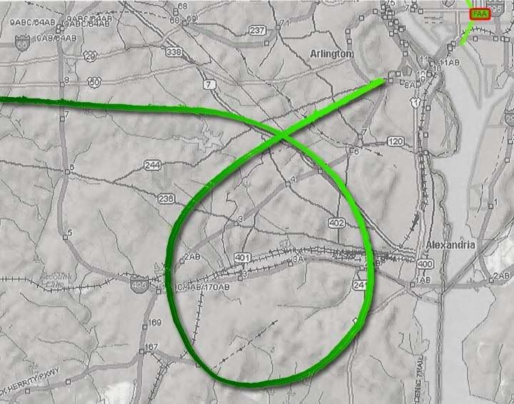 Now, how can this visual sighting “further validate the east side evidence” if it’s taking place from a west-facing office, prompted by a radar report of a plane in that direction? Originally I offered the quite reasonable and well-supported guess that the southeast report was simple error in reporting a radar track. Then it seemed there was a visual contact instead of radar, which complicated things. Then I learned that this observance was spurred by radar and confirmed southwest, and while we still aren’t sure where the momentary inversion of east and west came in, it is looking pretty much out the window as evidence.
Thursday, June 5, 2008
CHACONAS: AN INTOLERABLE INTERPRETATION
CHACONAS: AN INTOLERABLE INTERPRETATION
Adam Larson / Caustic Logic
The Frustrating Fraud
June 4 2008
update 6/9 12pm
At the Loose Change Forum recently CIT witness Steve Chaconas, as presented in The Pentagon Flyover, came up again. [interview runs 17:34-35:00 in the video] Chaconas was a charter boat captain out fishing with others on 9/11, near a sewage treatment plant on the Potomac a few miles south of the capitol. CIT feel “Steve’s account alone is enough to prove a military deception” by having a plane fly across the river east-to-west, bank right and apparently fly into the Pentagon off in the distance. Critical forum member Bret08 pointed out that “Chiconas [sic] is a human being giving his judgement and perceptions. He is not infallible,” and asked his fellow members “Are we even sure that the plane he saw was AA77/decoy?” He’s exactly right to wonder about this, if not terribly articulate about it. He was of course hit with slings and arrows for his criticism. CIT ally Bitterman snapped back:
“Hey Bret! WTF! What is wrong with you? Wait, wait......don't tell me.....I already know what you do. It pisses me off. […] in APRIL, you asked this SAME QUESTION. Remember when we trounced you because you still didn't get it, and we informed you that Steve CAN tell the difference between a turbo prop and a jet airliner?!?!?!
4 engine turbo prop vs. a 2 engine jet. AGAIN, DO NOT ASK THIS QUESTION AGAIN. Your motives are obvious to me, but I have to play by the rules. So, for the last time....here is the answer to your STUPID question. [provides the quote I’ll post below] So? WTF man. WHY are you here? Who are you? Why are you important? How old are you? You're credible how? […] If this is ALL you bring to the table, then STFU.”
At this point the moderators stepped in. “JFK” is no Jack Kennedy – he’s also a moderator at plane-pod-promoting letsrollforum and seems to think he can make any tripe look noble with his pensive presidential avatar and management of ideological differences in the name of "9/11 Truth." In response to Bitterman’s barely-provoked tirade, JFK said “Brett is tolerated here simply in case if we overlook something.... Other than that I ignore him for the most part.” Further denunciations came unmoderated from Avenger not Aldo, and Domenick DiMaggio not CIT.
I’d guess that Brett08 is tolerated there because he is timid and not studied on the details, and because they need some on-site opposition. I know I wouldn’t be tolerated for a minute in the current climate (I’m “Deleted User” there, voluntarily, but it’s devolved since then). I know to point out that all we have for proof of the decoy white airliner thing crossing the river is this ONE witness who saw the final bank and dive preceded by a crossing of the river by what he feels is one and the same plane.
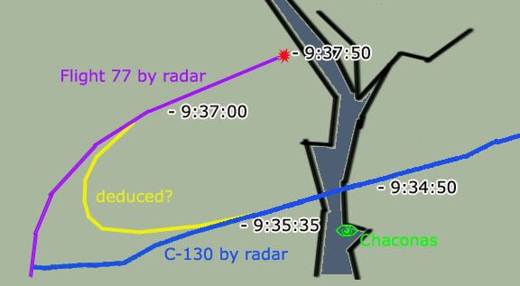
The pivotal part is where he saw it crossing close to him, considering the C-130 flown by Lt Col Steve O’Brien that followed after 77 to investigate the crash site crossed the river roughly when and exactly where Chaconas’ plane crossed. It has been reasonably proposed by Brett and myself and others that he actually saw the C-130 and just thought it was an airliner.
I’m not bothering now with a full deconstruction, but my opinion on Chaconas is that he’s neither correct nor 100% honest in his account, and neither is he outright lying, and almost certainly not any kind of “disinfo agent.” Consider this graphic: A perfectly honest and unbiased observer might connect these two maneuvers with a deduced bank, considering the proximity of the two path in time and space. Add in his apparent desire to boost the mystery and ‘unanswered questions’ surrounding 9/11 [27:00 in the video], a sentiment similar to that of Bob Pugh [video here, 30:30 on] and such deduction seems entirely too likely to be ignored.
Consider also his curious vagueness on characteristics of ‘the plane’ as it passed nearest to him:
Ranke: “Can you describe the jet for us? Did you notice how many engines it had?”
Chaconas: "I don’t recall anything specific about the airplane, and again, it was far enough away to where we, you know to me, it looked like a commercial airliner…”
Ranke: “How about the color though?”
Chaconas: “Nothing specific about it at all.” [25:05]
This raises a question for CIT. Guys, of all the witnesses you’ve interviewed, how many have flat refused to specify the color when asked? And why is it this one?
In closing, I’ll remind the reader that no other witnesses in the area have yet been found to corroborate this ONE apparent river-crossing by the decoy. And this pivotal and lonely account is based on a few words, like the hard point Bitterman slapped Bret08 with to certify it was one plane, and that an airliner. Carefully re-read this important passage: “and again, it was far enough away to where we, you know to me, it looked like a commercial airliner…” That’s a lot of qualifiers. It was far enough away that to me it LOOKED LIKE an airliner. So it was an airliner! The logical extension of this is that if it were closer, it might look to him or to anyone less like one and, perhaps, more like a C-130. The qualifiers indicate that somewhere in that brain Chaconas knows this.
ETA: And the fact that CIT passed up the chance to show him their ever-present E4B and C130 photos [nowhere in the video] for comparison indicates that they knew it too.
ETA: There will be no Chaconas update posts, and after this ETA no more additions to the post body, since Ranke said "that's it?" in the comments. I don't want to change the context on him. I will include additional marks against their literal interpretation in the growing comments section below.
Adam Larson / Caustic Logic
The Frustrating Fraud
June 4 2008
update 6/9 12pm
At the Loose Change Forum recently CIT witness Steve Chaconas, as presented in The Pentagon Flyover, came up again. [interview runs 17:34-35:00 in the video] Chaconas was a charter boat captain out fishing with others on 9/11, near a sewage treatment plant on the Potomac a few miles south of the capitol. CIT feel “Steve’s account alone is enough to prove a military deception” by having a plane fly across the river east-to-west, bank right and apparently fly into the Pentagon off in the distance. Critical forum member Bret08 pointed out that “Chiconas [sic] is a human being giving his judgement and perceptions. He is not infallible,” and asked his fellow members “Are we even sure that the plane he saw was AA77/decoy?” He’s exactly right to wonder about this, if not terribly articulate about it. He was of course hit with slings and arrows for his criticism. CIT ally Bitterman snapped back:
“Hey Bret! WTF! What is wrong with you? Wait, wait......don't tell me.....I already know what you do. It pisses me off. […] in APRIL, you asked this SAME QUESTION. Remember when we trounced you because you still didn't get it, and we informed you that Steve CAN tell the difference between a turbo prop and a jet airliner?!?!?!
4 engine turbo prop vs. a 2 engine jet. AGAIN, DO NOT ASK THIS QUESTION AGAIN. Your motives are obvious to me, but I have to play by the rules. So, for the last time....here is the answer to your STUPID question. [provides the quote I’ll post below] So? WTF man. WHY are you here? Who are you? Why are you important? How old are you? You're credible how? […] If this is ALL you bring to the table, then STFU.”
At this point the moderators stepped in. “JFK” is no Jack Kennedy – he’s also a moderator at plane-pod-promoting letsrollforum and seems to think he can make any tripe look noble with his pensive presidential avatar and management of ideological differences in the name of "9/11 Truth." In response to Bitterman’s barely-provoked tirade, JFK said “Brett is tolerated here simply in case if we overlook something.... Other than that I ignore him for the most part.” Further denunciations came unmoderated from Avenger not Aldo, and Domenick DiMaggio not CIT.
I’d guess that Brett08 is tolerated there because he is timid and not studied on the details, and because they need some on-site opposition. I know I wouldn’t be tolerated for a minute in the current climate (I’m “Deleted User” there, voluntarily, but it’s devolved since then). I know to point out that all we have for proof of the decoy white airliner thing crossing the river is this ONE witness who saw the final bank and dive preceded by a crossing of the river by what he feels is one and the same plane.
The pivotal part is where he saw it crossing close to him, considering the C-130 flown by Lt Col Steve O’Brien that followed after 77 to investigate the crash site crossed the river roughly when and exactly where Chaconas’ plane crossed. It has been reasonably proposed by Brett and myself and others that he actually saw the C-130 and just thought it was an airliner.
I’m not bothering now with a full deconstruction, but my opinion on Chaconas is that he’s neither correct nor 100% honest in his account, and neither is he outright lying, and almost certainly not any kind of “disinfo agent.” Consider this graphic:
 A perfectly honest and unbiased observer might connect these two maneuvers with a deduced bank, considering the proximity of the two path in time and space. Add in his apparent desire to boost the mystery and ‘unanswered questions’ surrounding 9/11 [27:00 in the video], a sentiment similar to that of Bob Pugh [video here, 30:30 on] and such deduction seems entirely too likely to be ignored.
 Consider also his curious vagueness on characteristics of ‘the plane’ as it passed nearest to him:
Ranke: “Can you describe the jet for us? Did you notice how many engines it had?”
Chaconas: "I don’t recall anything specific about the airplane, and again, it was far enough away to where we, you know to me, it looked like a commercial airliner…”
Ranke: “How about the color though?”
Chaconas: “Nothing specific about it at all.” [25:05]
This raises a question for CIT. Guys, of all the witnesses you’ve interviewed, how many have flat refused to specify the color when asked? And why is it this one?
In closing, I’ll remind the reader that no other witnesses in the area have yet been found to corroborate this ONE apparent river-crossing by the decoy. And this pivotal and lonely account is based on a few words, like the hard point Bitterman slapped Bret08 with to certify it was one plane, and that an airliner. Carefully re-read this important passage: “and again, it was far enough away to where we, you know to me, it looked like a commercial airliner…” That’s a lot of qualifiers. It was far enough away that to me it LOOKED LIKE an airliner. So it was an airliner! The logical extension of this is that if it were closer, it might look to him or to anyone less like one and, perhaps, more like a C-130. The qualifiers indicate that somewhere in that brain Chaconas knows this.
ETA: And the fact that CIT passed up the chance to show him their ever-present E4B and C130 photos [nowhere in the video] for comparison indicates that they knew it too.
ETA: There will be no Chaconas update posts, and after this ETA no more additions to the post body, since Ranke said "that's it?" in the comments. I don't want to change the context on him. I will include additional marks against their literal interpretation in the growing comments section below.
Wednesday, June 4, 2008
A VISUAL ENCOUNTER?
A VISUAL ENCOUNTER?
Adam Larson / Caustic Logic
The Frustrating Fraud
June 4 2008 2am
Colin Scoggins was the manager of FAA’s Boston Center as the attacks of 9/11 unfolded around him nearly seven years ago. He played an unexpectedly crucial role relaying information between the FAA, NEADS and others, as one can hear listening to the NORAD tapes released in 2004. Perhaps most famously he was the one who passed on the much-speculated on and unfortunate report at 9:21 am that Flight 11 was still airborne. I’ve been sent a copy of an off-line, detailed account Scoggins wrote, and was even able to make e-mail contact recently with Scoggins himself.
While I’m still trying to get his take on my own Flight 11 theory, he’s given me a puzzling insight into a lesser erred report he had to relay, which I had already covered in six miles southeast, as it related to CIT’s East-of-the-Potomac case. The call Scoggins made, at 9:35:41 am, was essentially this: “Latest report, aircraft [inaudible] six miles southeast of the White House,’ a report soon changed to “six southwest, six southwest of the White House and deviating away.” It was clear that he was passing on information from someone else, but how those people had become aware was not totally clear. I had presumed he was passing on a seen radar track, and that the change from SE to SW was a correction, providing a "brilliant indication" that the path released by the NTSB was “the one seen by radar controllers on 9/11” - a plane deviating away six miles southwest of the White House. When I asked Mr. Scoggins about it, however, it turned out more complex than I thought it would.
I asked, again presuming a radar track, “was the plane your people were watching ever on the east side of the Potomac? Was SE->SW an error->correction or correct placement->update situation?” He wasn’t sure at all on the reason for the change, which stands to reason given the general overload of the morning:
“I immediately called NEADS, and was advising them what I was hearing. They changed the direction so I repeated what I heard. […] So the real question is did AAL77 cross the Potomac, I don't know. I'm 99.9% it did slam into the pentagon, on what route of flight I have no idea, other than what has been published.”
He told me off the bat that “I never saw the plane, our radar doesn't go down that far,” meaning south, as he later clarified “our radar only goes down part way through New Jersey.” The information was being handed to him on a Telcon, a telephone (?) conference, with others at FAA, and passing it on to NEADS, where it linked to military response/lack thereof. He’s not certain who he was talking to or where they were calling from, but seems pretty sure who and where through some personal research (though he isn’t telling me yet). On Scoggins’ advice, as he said in an interview with JREF member Ref, NEADS made a call to Washington Center, where he thought there’d be better intelligence.
“NEADS did turn around and immediately called Washington Center, and advised them that “Boston Center reported and aircraft six miles from the White House”, the response from the Washington Center person who received this call was unbelievable, “How would Boston Center know if an aircraft is six miles from the White House” “CLICK” they hung up.”
I was under the impression Washington center was tracking, or aware of Reagan National's tracking of 77 at this time (about two minutes before impact, near the end of the loop), and would have been the source of this intel. But apparently they rejected it when it was handed to them from the outside. Perhaps they were just too busy tracking the plane to take accurate but minutes-old hearsay about it? But it’s a good question, and the one I was asking; “How would Boston Center know if an aircraft is six miles from the White House?” Scoggins told me:
“I was on aTELCON and there were people who were actually looking at their window and saw the plane, they were speaking it verbatim on the phone to the TELCON. So it was a visual encounter, I assume they were in FAA HQ on Independence AVE. I know one persons name who was there and according to a USA article on around 9/20/01 I have an idea who said it on the phone, and he is the same person that I received the Phantom 11 call on.”
Was he just confusing a human voice saying it for a human eye having seen it? I asked for clarification “are you pretty sure it was not radar that was giving this info?” I would guess FAA headquarters had a link to radar controllers, if not their own screens. He clarified “when they say six miles they probably would have meant statue miles, not nautical,” which would equal a slightly lesser distance. He also pointed out that “they were estimating on a visual of an aircraft moving pretty quick,” and that
“I don't know what office window they were looking from, I've always felt it was FAA HQ […] I am 99 % sure that the statement was made by visual, the same person who stated that this aircraft was 6 NM southwest, is the same person who told me that AAL11 was still in the air.”
I still have to doubt that this is so, Colin being 99% sure or not, because when you turn this into an eyewitness account it falls apart. The main reason is distance: I took a crop of the picture CIT took from witness Timmerman’s apartment, which shows the Pentagon in the mid-distance and the Washington monument clearly visible across the river at 2.4 miles. But its height of 555 feet is 400 feet greater than the length of a Boeing 757. Here is how Flight 77 would have looked if it were flying near the monument, nearly 2 1/2 miles distant:
 And here is an experiment in reverse, a view west from atop the Monument. The location the other photo was taken from is marked with a red eye on this 400-foot-wide building. Again, a 757 is slapped in to scale just above the building, 2.4 miles away.
 Now here’s the building Scoggins thinks the call came in from – FAA Headquarters on Independence Avenue in DC. At about a mile south of the White Hose and fairly near the Washington monument, they were calling in a report of a plane about five miles away from their ten-story building. Considering the experiments above, what would a witness at FAA HQ see five miles distant? Enough to report as a plane doing this and that? It's as likely to be reported as a gnat on the window, IF the witness was staring an inch from the pane. they certainly would be able to visually pick it out if they were first tipped off by, say, a radar report of a plane five miles southeast, er, southwest. But to notice it with no prompting makes little sense to me.

So I guess it doesn't really matter, but Scoggins could just have a false impression or imprecise memory, and then again he could be right. It is possible that some hawkeye saw it happening not terribly far away. It's possible but unlikely, and radar still seems right for this accurate but briefly inverted report of Flight 77's location.
Adam Larson / Caustic Logic
The Frustrating Fraud
June 4 2008 2am
Colin Scoggins was the manager of FAA’s Boston Center as the attacks of 9/11 unfolded around him nearly seven years ago. He played an unexpectedly crucial role relaying information between the FAA, NEADS and others, as one can hear listening to the NORAD tapes released in 2004. Perhaps most famously he was the one who passed on the much-speculated on and unfortunate report at 9:21 am that Flight 11 was still airborne. I’ve been sent a copy of an off-line, detailed account Scoggins wrote, and was even able to make e-mail contact recently with Scoggins himself.
While I’m still trying to get his take on my own Flight 11 theory, he’s given me a puzzling insight into a lesser erred report he had to relay, which I had already covered in six miles southeast, as it related to CIT’s East-of-the-Potomac case. The call Scoggins made, at 9:35:41 am, was essentially this: “Latest report, aircraft [inaudible] six miles southeast of the White House,’ a report soon changed to “six southwest, six southwest of the White House and deviating away.” It was clear that he was passing on information from someone else, but how those people had become aware was not totally clear. I had presumed he was passing on a seen radar track, and that the change from SE to SW was a correction, providing a "brilliant indication" that the path released by the NTSB was “the one seen by radar controllers on 9/11” - a plane deviating away six miles southwest of the White House. When I asked Mr. Scoggins about it, however, it turned out more complex than I thought it would.
I asked, again presuming a radar track, “was the plane your people were watching ever on the east side of the Potomac? Was SE->SW an error->correction or correct placement->update situation?” He wasn’t sure at all on the reason for the change, which stands to reason given the general overload of the morning:
“I immediately called NEADS, and was advising them what I was hearing. They changed the direction so I repeated what I heard. […] So the real question is did AAL77 cross the Potomac, I don't know. I'm 99.9% it did slam into the pentagon, on what route of flight I have no idea, other than what has been published.”
He told me off the bat that “I never saw the plane, our radar doesn't go down that far,” meaning south, as he later clarified “our radar only goes down part way through New Jersey.” The information was being handed to him on a Telcon, a telephone (?) conference, with others at FAA, and passing it on to NEADS, where it linked to military response/lack thereof. He’s not certain who he was talking to or where they were calling from, but seems pretty sure who and where through some personal research (though he isn’t telling me yet). On Scoggins’ advice, as he said in an interview with JREF member Ref, NEADS made a call to Washington Center, where he thought there’d be better intelligence.
“NEADS did turn around and immediately called Washington Center, and advised them that “Boston Center reported and aircraft six miles from the White House”, the response from the Washington Center person who received this call was unbelievable, “How would Boston Center know if an aircraft is six miles from the White House” “CLICK” they hung up.”
I was under the impression Washington center was tracking, or aware of Reagan National's tracking of 77 at this time (about two minutes before impact, near the end of the loop), and would have been the source of this intel. But apparently they rejected it when it was handed to them from the outside. Perhaps they were just too busy tracking the plane to take accurate but minutes-old hearsay about it? But it’s a good question, and the one I was asking; “How would Boston Center know if an aircraft is six miles from the White House?” Scoggins told me:
“I was on aTELCON and there were people who were actually looking at their window and saw the plane, they were speaking it verbatim on the phone to the TELCON. So it was a visual encounter, I assume they were in FAA HQ on Independence AVE. I know one persons name who was there and according to a USA article on around 9/20/01 I have an idea who said it on the phone, and he is the same person that I received the Phantom 11 call on.”
Was he just confusing a human voice saying it for a human eye having seen it? I asked for clarification “are you pretty sure it was not radar that was giving this info?” I would guess FAA headquarters had a link to radar controllers, if not their own screens. He clarified “when they say six miles they probably would have meant statue miles, not nautical,” which would equal a slightly lesser distance. He also pointed out that “they were estimating on a visual of an aircraft moving pretty quick,” and that
“I don't know what office window they were looking from, I've always felt it was FAA HQ […] I am 99 % sure that the statement was made by visual, the same person who stated that this aircraft was 6 NM southwest, is the same person who told me that AAL11 was still in the air.”
I still have to doubt that this is so, Colin being 99% sure or not, because when you turn this into an eyewitness account it falls apart. The main reason is distance: I took a crop of the picture CIT took from witness Timmerman’s apartment, which shows the Pentagon in the mid-distance and the Washington monument clearly visible across the river at 2.4 miles. But its height of 555 feet is 400 feet greater than the length of a Boeing 757. Here is how Flight 77 would have looked if it were flying near the monument, nearly 2 1/2 miles distant:
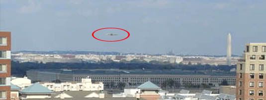 And here is an experiment in reverse, a view west from atop the Monument. The location the other photo was taken from is marked with a red eye on this 400-foot-wide building. Again, a 757 is slapped in to scale just above the building, 2.4 miles away.
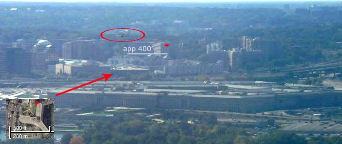
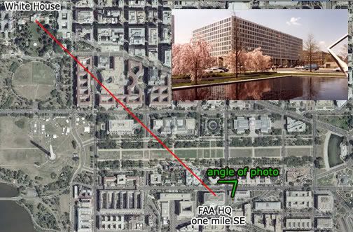 Now here’s the building Scoggins thinks the call came in from – FAA Headquarters on Independence Avenue in DC. At about a mile south of the White Hose and fairly near the Washington monument, they were calling in a report of a plane about five miles away from their ten-story building. Considering the experiments above, what would a witness at FAA HQ see five miles distant? Enough to report as a plane doing this and that? It's as likely to be reported as a gnat on the window, IF the witness was staring an inch from the pane. they certainly would be able to visually pick it out if they were first tipped off by, say, a radar report of a plane five miles southeast, er, southwest. But to notice it with no prompting makes little sense to me.
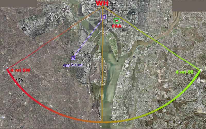
So I guess it doesn't really matter, but Scoggins could just have a false impression or imprecise memory, and then again he could be right. It is possible that some hawkeye saw it happening not terribly far away. It's possible but unlikely, and radar still seems right for this accurate but briefly inverted report of Flight 77's location.
Monday, May 12, 2008
SIX MILES SOUTHEAST
SIX MILES SOUTHEAST
Adam Larson / Caustic Logic
The Frustrating Fraud
May 12 2008
last update 5/14 12am
Citizen Investigation Team (CIT) now promote four primary claims regarding the decoy aircraft that everybody thought hit the Pentagon; First and foremost is their original North of the Citgo (NoC) claim, which necessitates the pivotal but otherwise unproven OtP (Over the Pentagon) claim (my own acronym, the others are theirs). This is also supported by the Over-the-Navy Annex claim (ONA) explicitly offered by Paik with supports recently wrangled from other witness accounts. And then there’s the tangential but important East of the Potomac (EoP) aspect, which is at issue in this article. As CIT co-founder Craig Ranke recently said “In addition to proving that the plane was on the north side of the former citgo gas station we can now also prove that it came from east of the Potomac River and actually flew over DC skies! This is absolutely fatal to the official flight path that never has the plane over DC skies at all.” [source]
I haven't tried so far to systematically debunk the EoP claim, perhaps out of fear that it would prove correct. When I finally decided to face my possible fear and finally tackle this case but found I cannot disprove it. It’s a strong enough case I don’t even feel like trying very hard, except on the one point I already did so with. I will have a fuller explanation of my general failure regarding EoP later, for now here is that one evidentiary support that I've looked at closely.
Ironically, this proof of the plane being over the river from where radar shows it is from - people whose job it was to watch where the radar was showing the plane. If CIT's reading here is correct, it would again prove the later-released radar data fraudulent, so it's a big deal. They cite the NORAD tapes, and a 09:35:41 call from Colin Scoggins at FAA’s Boston Center to Northeast Air Defense Sector (NEADS) base “Huntress.” [transcribed from audio]
Boston (Scoggins): “Latest report, aircraft [inaudible] six miles southeast of the White House.”
Huntress: “Six miles southeast of the White House?”
Boston: “Yup. [to someone else] East? He's moving away?”
Huntress: “Southeast from the White House.”
Boston: “Aircraft is moving away.”
Huntress: “Moving away from the White House?”
Boston: “Yeah.…”
[…questions on ID…]
Boston: “If you wanna hold on a second, [inaudible] people down there looking.”
[Long pause – to someone else] “Where was that position?” [backround on Boston end, inaudible with emphasis on last syllable rhyming with yes.]
Boston: “Six.. six southwest, six southwest of the White House and deviating away.” [emph in original]
Huntress: “Deviating away. You don't have a type aircraft, you don't know who he is…”
Boston: “Nothing, nothing. We're over here in Boston so I have no clue. That—hopefully somebody in Washington would have better—information for you.”
 The direction of the original deviation isn’t clear other than ‘away’ from the capitol, but CIT is quite confident in placing the plane southeast of there and moving west, eventually crossing the river due south of the capitol, and continuing to six miles away on the other side in time for the update 35 seconds later of it being SW (it was either flying very fast or the second report was much fresher than the first). An alternate guess is it was never east of the river, and the change from southeast to southwest was a correction of the same last reported position.
I could just stop there by offering that guess, but when I tried to earlier, Ranke rebuffed it by stating of the above dialog “that wasn't an accident. He even confirmed it and THEN came back with an update of it being SW which makes perfect sense.” [source] I cannot prove that this is a wrong interpretation; perhaps Colin really was watching the real, pre-alteration radar data when it symmetrically traversed the river. And supporting this possibility is the fact that, as Ranke points out, “Scoggins wasn't the only ATC to report a plane east of the river either.” Oh no, his claim is supported by Major Kevin Nasypany, NEADS mission-crew commander, also from the NORAD tapes:
09:36:23
Nasypany: ‘I got a aircraft six miles east of the White House! Get your fighters there as soon as possible!”
Unidentified: “That came from Boston?”
[…]
Nasypany: “‘We've got an aircraft deviating eight miles east of the White House right now.”
Notice that this report follows Scoggins’ by only 40 seconds and someone feels it may have been based on that info from Boston. Is it possible he’s just repeating the report cited above rather than independently confirming it? Is "eight miles” an anticipated distance, an error, or real info? Does east mean southeast, or had it moved north? Most interestingly, if we take this as independent confirmation, it shows that that plane was not only east of the Potomac, but also deviating further EoP, rather than towards the river to cross west as CIT feels happened next.
Perhaps it’s all a complex cover-up where they altered some parts of the record to hide the real plane while other parts are let through, to provide cover for something, or something. I can’t rule this out as a possibility, but my tentative alternate guess – for whatever it’s worth – is that the report Scoggins received had one error - southwest was reported as southeast, and both Scoggins and Nasypany just echoed this error. A bit of confusion is evident in what Nasypany said later to Vanity Fair’s Micheal Bronner: "Six miles south, or west, or east of the White House is—it's seconds [...] Airliners traveling at 400-plus knots, it's nothing. It's seconds away from that location." That is, they weren’t worried at the moment about which direction the hostile craft would have to fly for a few seconds to hit the White House – they were worried about how few seconds that was, and how to get fighters to that small area fast. They did sort out the error, if that's what it was, but the fighters didn't get there 'til far too late.
Anyway, you can test this east-west error reading here: refer to this graphic of the radar flight path, marked roughly with lat-long cross-points from the FDR (corrected and approximate), and a 6-mile arc south and west from the White House. Then read the reports below, corrected. update: As explained in the comments below, 6 miles meant nautiical miles which - I think - is about 7 land miles. So note this - the red arc is set a bit too small.

Scoggins 9:35:41: “Latest report, aircraft [inaudible] six miles southwest of the White House.”
“Yup. West—he's moving away? Aircraft is moving away.”
“Six.. six southwest of the White House and deviating away.”
Nasypany 9:36:23: "I got a aircraft six miles [south]west of the White House! […]
We've got an aircraft deviating eight miles [south]west of the White House right now.”
One word, one dyslexic slip in the information chain, is all it takes to turn this into a brilliant indication that the above path is the one seen by radar controllers on 9/11. On the other hand, a different reading could, with a few complications, be found to support the EoP claim, which, again, I still cannot disprove.
---
Update: SPreston has used this "six miles southeast" evidence to say the FDR path is PROVEN a lie.:
"PROVEN: This Flight Path Crossed Over the Potomac, Over DC, and Six Miles Southeast of the White House [...] How come all the witnesses actually interviewed place the actual aircraft east of the Potomac and over Washington DC and 6 miles southeast of the White House and banking around Reagan National? "
None of the witnesses says this that I've seen. One has it looping around from the east (Chaconas and he alone) and this location and distance is not from any interviewed witness, but from the above-described possible error. Almost all other witnesses were west of the Potomac (a few just east as well but looking west). SP, help me out if I'm missing something! Comments open...
Adam Larson / Caustic Logic
The Frustrating Fraud
May 12 2008
last update 5/14 12am
Citizen Investigation Team (CIT) now promote four primary claims regarding the decoy aircraft that everybody thought hit the Pentagon; First and foremost is their original North of the Citgo (NoC) claim, which necessitates the pivotal but otherwise unproven OtP (Over the Pentagon) claim (my own acronym, the others are theirs). This is also supported by the Over-the-Navy Annex claim (ONA) explicitly offered by Paik with supports recently wrangled from other witness accounts. And then there’s the tangential but important East of the Potomac (EoP) aspect, which is at issue in this article. As CIT co-founder Craig Ranke recently said “In addition to proving that the plane was on the north side of the former citgo gas station we can now also prove that it came from east of the Potomac River and actually flew over DC skies! This is absolutely fatal to the official flight path that never has the plane over DC skies at all.” [source]
I haven't tried so far to systematically debunk the EoP claim, perhaps out of fear that it would prove correct. When I finally decided to face my possible fear and finally tackle this case but found I cannot disprove it. It’s a strong enough case I don’t even feel like trying very hard, except on the one point I already did so with. I will have a fuller explanation of my general failure regarding EoP later, for now here is that one evidentiary support that I've looked at closely.
Ironically, this proof of the plane being over the river from where radar shows it is from - people whose job it was to watch where the radar was showing the plane. If CIT's reading here is correct, it would again prove the later-released radar data fraudulent, so it's a big deal. They cite the NORAD tapes, and a 09:35:41 call from Colin Scoggins at FAA’s Boston Center to Northeast Air Defense Sector (NEADS) base “Huntress.” [transcribed from audio]
Boston (Scoggins): “Latest report, aircraft [inaudible] six miles southeast of the White House.”
Huntress: “Six miles southeast of the White House?”
Boston: “Yup. [to someone else] East? He's moving away?”
Huntress: “Southeast from the White House.”
Boston: “Aircraft is moving away.”
Huntress: “Moving away from the White House?”
Boston: “Yeah.…”
[…questions on ID…]
Boston: “If you wanna hold on a second, [inaudible] people down there looking.”
[Long pause – to someone else] “Where was that position?” [backround on Boston end, inaudible with emphasis on last syllable rhyming with yes.]
Boston: “Six.. six southwest, six southwest of the White House and deviating away.” [emph in original]
Huntress: “Deviating away. You don't have a type aircraft, you don't know who he is…”
Boston: “Nothing, nothing. We're over here in Boston so I have no clue. That—hopefully somebody in Washington would have better—information for you.”
 The direction of the original deviation isn’t clear other than ‘away’ from the capitol, but CIT is quite confident in placing the plane southeast of there and moving west, eventually crossing the river due south of the capitol, and continuing to six miles away on the other side in time for the update 35 seconds later of it being SW (it was either flying very fast or the second report was much fresher than the first). An alternate guess is it was never east of the river, and the change from southeast to southwest was a correction of the same last reported position.
 I could just stop there by offering that guess, but when I tried to earlier, Ranke rebuffed it by stating of the above dialog “that wasn't an accident. He even confirmed it and THEN came back with an update of it being SW which makes perfect sense.” [source] I cannot prove that this is a wrong interpretation; perhaps Colin really was watching the real, pre-alteration radar data when it symmetrically traversed the river. And supporting this possibility is the fact that, as Ranke points out, “Scoggins wasn't the only ATC to report a plane east of the river either.” Oh no, his claim is supported by Major Kevin Nasypany, NEADS mission-crew commander, also from the NORAD tapes:
09:36:23
Nasypany: ‘I got a aircraft six miles east of the White House! Get your fighters there as soon as possible!”
Unidentified: “That came from Boston?”
[…]
Nasypany: “‘We've got an aircraft deviating eight miles east of the White House right now.”
Notice that this report follows Scoggins’ by only 40 seconds and someone feels it may have been based on that info from Boston. Is it possible he’s just repeating the report cited above rather than independently confirming it? Is "eight miles” an anticipated distance, an error, or real info? Does east mean southeast, or had it moved north? Most interestingly, if we take this as independent confirmation, it shows that that plane was not only east of the Potomac, but also deviating further EoP, rather than towards the river to cross west as CIT feels happened next.
Perhaps it’s all a complex cover-up where they altered some parts of the record to hide the real plane while other parts are let through, to provide cover for something, or something. I can’t rule this out as a possibility, but my tentative alternate guess – for whatever it’s worth – is that the report Scoggins received had one error - southwest was reported as southeast, and both Scoggins and Nasypany just echoed this error. A bit of confusion is evident in what Nasypany said later to Vanity Fair’s Micheal Bronner: "Six miles south, or west, or east of the White House is—it's seconds [...] Airliners traveling at 400-plus knots, it's nothing. It's seconds away from that location." That is, they weren’t worried at the moment about which direction the hostile craft would have to fly for a few seconds to hit the White House – they were worried about how few seconds that was, and how to get fighters to that small area fast. They did sort out the error, if that's what it was, but the fighters didn't get there 'til far too late.
Anyway, you can test this east-west error reading here: refer to this graphic of the radar flight path, marked roughly with lat-long cross-points from the FDR (corrected and approximate), and a 6-mile arc south and west from the White House. Then read the reports below, corrected. update: As explained in the comments below, 6 miles meant nautiical miles which - I think - is about 7 land miles. So note this - the red arc is set a bit too small.
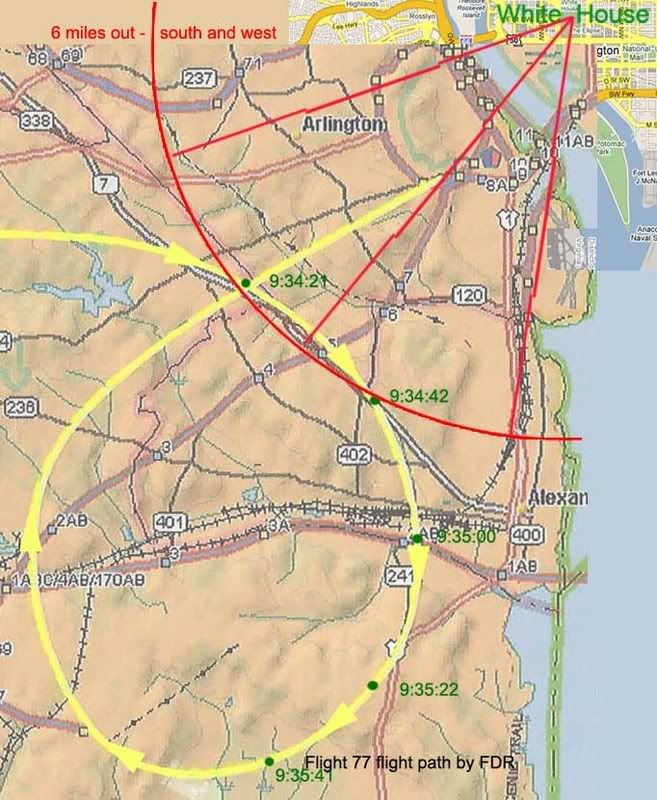
Scoggins 9:35:41: “Latest report, aircraft [inaudible] six miles southwest of the White House.”
“Yup. West—he's moving away? Aircraft is moving away.”
“Six.. six southwest of the White House and deviating away.”
Nasypany 9:36:23: "I got a aircraft six miles [south]west of the White House! […]
We've got an aircraft deviating eight miles [south]west of the White House right now.”
One word, one dyslexic slip in the information chain, is all it takes to turn this into a brilliant indication that the above path is the one seen by radar controllers on 9/11. On the other hand, a different reading could, with a few complications, be found to support the EoP claim, which, again, I still cannot disprove.
---
Update: SPreston has used this "six miles southeast" evidence to say the FDR path is PROVEN a lie.:
"PROVEN: This Flight Path Crossed Over the Potomac, Over DC, and Six Miles Southeast of the White House [...] How come all the witnesses actually interviewed place the actual aircraft east of the Potomac and over Washington DC and 6 miles southeast of the White House and banking around Reagan National? "
None of the witnesses says this that I've seen. One has it looping around from the east (Chaconas and he alone) and this location and distance is not from any interviewed witness, but from the above-described possible error. Almost all other witnesses were west of the Potomac (a few just east as well but looking west). SP, help me out if I'm missing something! Comments open...
Tuesday, February 12, 2008
C-130 FLIGHT PATH VIDEO
C-130 FLIGHT PATH VIDEO:
NO CONTRADICTION EXCEPT WITH CIT
Adam Larson / Caustic Logic
The Frustrating Fraud
February 12 2008
update 9/8/08
I posted this at Youtube a wile back, my most ambitious video yet, almost a mini-documentary in itself. I've been hazy on the details of the C-130 at the Pentagon, but now that Citizen Investigation Team is pushing an interpretation of it to bolster their overflight path construct, I felt a need to dig in to the available data to see what truly contradicted what. Craig and Aldo believe pilot Steve O'Brien's verbal accounts contradict the radar data (fraudulent, of course) and support their witness-compilation flight path for 77, as explained at this LCF thread (comments from "Deleted User" are from me - I asked to have my LCF account closed, not realizing how drastic it would look). To understand my reasons for assembling this, it might help to read the CIT link at top and/or this post at my blog. See also this attempted discussion thread at Above Top Secret.com.
This is the result so far: a collage of all the mutually-supporting evidence of where that plane flew and where and how it interacted with Flight 77 on its way to its fate and in its pass near the Pentagon after that. I'm able to incorporate on-the-ground witness accounts, on-site video, radar animation, and O'Brien's own words and gestures, as well as some of Aldo's own spoken words. Nothing in this video contradicts the other parts.
Online Videos by Veoh.com
Page link - Veoh
To understand the video itself, especially regarding its lower-than-hoped resolution, refer to these graphics and additional notes:
 This is the radar screen labeled, which is unreadable in the video. The raw radar data was released to US researcher John Farmer, and this animation created by Italian researcher Marco Bolletino, downloaded from Farmer's AAL77.com.
 first frames of Anthony Tribby's amateur video of the post-attack scene, taken almost due south of impact. The smoke has not reached the top of the screen, putting this at somewhere from, say, 10-30 seconds after impact. The "UFO" I think is the C-130 emerges from behind the plume one minute and 45 seconds after this frame. It barely comes through at all in my video, and doesn't even look too good in the higher res original. The frame below is the clearest of the object, zooming in on it as 2:04.

The object is filmed from a moving position in the range shown below, ESE of the impact point, judging by passing landmarks. After being visible for 23 seconds, it disappears again behind the plume. Its overall direction of movement seems to be left-to-right (S-N) at first, curving away and departing along the rough line of sight from there (WNW). The red arc below shows the rough direction of flight, but does not attempt to re-create the exact placement or scale of the flight path. [update: any idiot who takes this as evidence of the location of the plane or the size of the arc is... an idiot. The ANC witnesses are READ as placing it right over the cemetery doing the same curve the radar shows but a few hundred feet off, and that this coincides with my curve here means nothing. I wasn't even trying to decide what it was over.
I haven't bothered downloading the special software and figuring out the raw data, but by Bolletino's animation, this is about what radar shows the C-130 doing approximately two minutes after the attack.

The departure from Andrews shown on radar is said by CIT to fatally contradict what O'Brien himself says; he flew "north and west" and had "a beautiful view" of the Capitol Mall as they crossed the Potomac on "the south side of the mall." [see links above] The departure on radar has him taking off north and then nearly west, crossing the river well south of but probably within visual range of the mall. Close enough for me. The departure shown is also a match for one of the standard patterns used at Andrews, the "Camp Springs One" departure. [explained by Boondoggled]

 That wasn't even in the video, nor was this bonus, for folks marveling over the mystery plane (left) with lopsided engines captured in a photo from 9/11 and previously passed off as the C-130. Here is that plane compared to a 4-engine C-130. Like a low-resolution mirror.
NO CONTRADICTION EXCEPT WITH CIT
Adam Larson / Caustic Logic
The Frustrating Fraud
February 12 2008
update 9/8/08
I posted this at Youtube a wile back, my most ambitious video yet, almost a mini-documentary in itself. I've been hazy on the details of the C-130 at the Pentagon, but now that Citizen Investigation Team is pushing an interpretation of it to bolster their overflight path construct, I felt a need to dig in to the available data to see what truly contradicted what. Craig and Aldo believe pilot Steve O'Brien's verbal accounts contradict the radar data (fraudulent, of course) and support their witness-compilation flight path for 77, as explained at this LCF thread (comments from "Deleted User" are from me - I asked to have my LCF account closed, not realizing how drastic it would look). To understand my reasons for assembling this, it might help to read the CIT link at top and/or this post at my blog. See also this attempted discussion thread at Above Top Secret.com.
This is the result so far: a collage of all the mutually-supporting evidence of where that plane flew and where and how it interacted with Flight 77 on its way to its fate and in its pass near the Pentagon after that. I'm able to incorporate on-the-ground witness accounts, on-site video, radar animation, and O'Brien's own words and gestures, as well as some of Aldo's own spoken words. Nothing in this video contradicts the other parts.
Online Videos by Veoh.com
Page link - Veoh
To understand the video itself, especially regarding its lower-than-hoped resolution, refer to these graphics and additional notes:
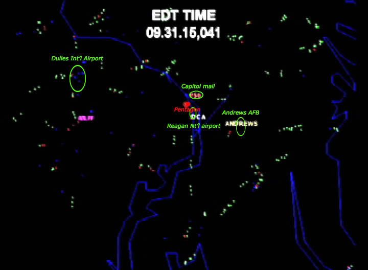 This is the radar screen labeled, which is unreadable in the video. The raw radar data was released to US researcher John Farmer, and this animation created by Italian researcher Marco Bolletino, downloaded from Farmer's AAL77.com.
  first frames of Anthony Tribby's amateur video of the post-attack scene, taken almost due south of impact. The smoke has not reached the top of the screen, putting this at somewhere from, say, 10-30 seconds after impact. The "UFO" I think is the C-130 emerges from behind the plume one minute and 45 seconds after this frame. It barely comes through at all in my video, and doesn't even look too good in the higher res original. The frame below is the clearest of the object, zooming in on it as 2:04.
 The object is filmed from a moving position in the range shown below, ESE of the impact point, judging by passing landmarks. After being visible for 23 seconds, it disappears again behind the plume. Its overall direction of movement seems to be left-to-right (S-N) at first, curving away and departing along the rough line of sight from there (WNW). The red arc below shows the rough direction of flight, but does not attempt to re-create the exact placement or scale of the flight path. [update: any idiot who takes this as evidence of the location of the plane or the size of the arc is... an idiot. The ANC witnesses are READ as placing it right over the cemetery doing the same curve the radar shows but a few hundred feet off, and that this coincides with my curve here means nothing. I wasn't even trying to decide what it was over.

I haven't bothered downloading the special software and figuring out the raw data, but by Bolletino's animation, this is about what radar shows the C-130 doing approximately two minutes after the attack.
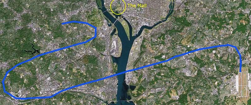
The departure from Andrews shown on radar is said by CIT to fatally contradict what O'Brien himself says; he flew "north and west" and had "a beautiful view" of the Capitol Mall as they crossed the Potomac on "the south side of the mall." [see links above] The departure on radar has him taking off north and then nearly west, crossing the river well south of but probably within visual range of the mall. Close enough for me. The departure shown is also a match for one of the standard patterns used at Andrews, the "Camp Springs One" departure. [explained by Boondoggled]

 That wasn't even in the video, nor was this bonus, for folks marveling over the mystery plane (left) with lopsided engines captured in a photo from 9/11 and previously passed off as the C-130. Here is that plane compared to a 4-engine C-130. Like a low-resolution mirror.
Wednesday, January 30, 2008
CIT'S C-130 FINDINGS RE: "FLIGHT 77"
CIT'S C-130 FINDINGS RE: "FLIGHT 77"
Adam Larson / Caustic Logic
The Frustrating Fraud
January 30 2008
Okay, so I'm banned for a week at the LCF for alluding to the well-known fact that Aldo Marquis is an asshole. [the events happen on page 8 of this thread, which is also about the C-130.] I will have more to write (and/or right) on this situation once I get some perspective. It's my first time being banned anywhere and I'm disappointed to find out my computer has been banned from allowing me to ever READ the forum, including the reason for my dismissal, or the answers CIT may or may not have offered to some questions I posed. Luckily I do have a old machine around to get around the IP block, and was barely able to read what followed. I'm not missing much it seems except continued evasion, decreased reason, argument from belligerence and incredible unchecked tirades from the CIT end. Really, some pretty insane activity from Aldo; it's like he wants out and has to do it the only way he knows - get banned for being to 'passionate' about 'truth' and 'justice' for people to handle.
On the other hand, Craig's response to my questions regarding witness Mrs. Hubbard were candid and useful.
But there was no response from either Aldo or Craig to these questions regarding their interpretation of the C-130 flight path and its 'actual' interaction with the fantasy flyover plane:
"Okay, I have a question about the outbound flight. Let's for a moment step back from the debate and go on the premise that your reading, north and west to just about over the capitol mall is correct, after which he describes his interaction with the plane, arcing from his left to north an then east, 10:00, 11:00 12;00 and descending. This part I agree with your reading, I think.
1) Is this graphic about right for what he saw that plane doing and about where?
 2) You've mentioned reports of the plane being southeast of the capitol. Was this before or after this passage do you think?
3) Does he describe the plane as silver or white? Is this the flyover White Jet he saw or something else?
4) Do you think he may have been seen the C-130 and is mistakenly describing its flight path? (kidding)"
I'm not being facetious or anything here; I'm truly baffled by the implications of the C-130 being just west of over the mall when "Flight 77" came in ahead of them from the left, curved to their north and east, descending on the way. From what I have seen and heard so far of CIT's take, that would put the plane looping north of the capitol, at some point prior to its impact. I therefore open this post to comments from CIT if they wish to explain their findings in more detail to help us all determine the SIGNIFICANCE of this interpretation. I'll copy all relevant comments and thoughts into this post before finalizing it. If they have nothing to offer, I'm going to take this path shown above as the best available reading of their C-130 findings regarding the path of "Flight 77."
I'd like to start with the above list of questions as offered at LCF on my way out, and add one more:
5) How much time do you gather elapsed after seeing this arc before O'Brien saw the explosion? "Three phone calls later" = roughly how many minutes? (a range is fine).
---
Update: After he ignored it at LCF and here, I posted these questions for Craig again in an Above Top Secret.com thread. He ignored it there as well but finally sent me an e-mail that reads as follows:
"You are dead wrong about our analysis and I refuse to discuss it in your disinfo thread at ATS or at your disinfo blog. You can wait for our new presentation scumbag.
Why do you keep intentionally spreading disinfo with your confusing ass, contradictory, deceptive ramblings? People see right through you Larson. You are blatantly deceptive. We have exposed you many times over and people do not have tolerance for your lies and spin any longer.
"The u-turn at the end is what is corroborated by eyewitness accounts, O'Brien's own account, and now also a video, taken by Anthony Tribby."
"A UFO for sure."
How can a UFO corroborate anything?
The placement of the UFO does not corroborate the RADES data anyway EVEN IF it is the C-130.
Why are you such a liar?
Why are you so dedicated to defending mass murder?
You disgust me."
---
[BTW: He's lying about the video and radar not matching, and the UFO is almost certainly the C-130. See my video he's talking about yourself here.]
So I’m left feeling like I must be onto something, but having to guess at what the deception I’m accused of actually is. They had been so damn sure it was just over the mall I figured it was leading up to something, but this didn’t seem quite right. It would give us an overall flight pattern like this:
At present then my guess is they have actually placed the C-130 somewhat south of the Capitol. As Craig had earlier said, hinting at a correlation with the Charter Boat Captain on the river south of Reagan National:
"We were always stumped with how O'Brien's account didn't make sense with the 2006 NTSB flight path of AA77 until we talked with our newest witness who was on the Potomac River who reveals that the NTSB flight path is false and that the plane came from the EAST of the river and looped around north timed perfectly with the explosion at the Pentagon!"
[source]
By this mapping above, 77 was looping north and east of the C-130 to NORTH OF THE CAPITOL 'timed perfectly' with the explosion a few miles to the southwest. So I'm left guessing that after all the yammering about how the plane could ONLY be right over the Capitol, that the English language mandates it, that anyone who places it any further south is a dishonest goal-post-moving scumbag... must be qualified. Only CIT is allowed to disregard the words of O'Brien saying "north and west" and a "beautiful view of the mall" to actually be well SOUTH of the mall AFTER ALL, to match up with the loop the Charter Boat Captain describes! The special privileges Citizen researchers afford themselves.
Now I'm unaware of just where the river witness places the flight path, but it's probably not as far south as it would have to be to approach the C-130 as shown on radar. But it is obviously further south than their original 'beautiful view' would necessitate, and shows that O'Brien's account is indeed open to interpretation in CIT's mind, whereas when I had tried to say the same thing as they were INSISTING on the infallibility of that graphic, they said things like this: "Power of suggestion, up is down, left is right, north is south. Lies.” [Craig responding to an incorrect assessment of my video] Or this: "Just because you said it Adam. You can change anything at anytime and it all makes sense. You can say anything, up is down and down is up. I understand.” [Asshole Marquis, both quotes from the LCF thread linked to at top]
So I am "dead wrong" in my direct reading of the same infallible evidence CIT has provided me. So their assessment was wrong. After they insisted it couldn't be. "Up" is "down" now I guess just because they say so, even tho it was a deceptive treasonous scumbag lie at first when I said it.
Duly noted, for the record, yet again... the hypocrisy never stops.
Adam Larson / Caustic Logic
The Frustrating Fraud
January 30 2008
Okay, so I'm banned for a week at the LCF for alluding to the well-known fact that Aldo Marquis is an asshole. [the events happen on page 8 of this thread, which is also about the C-130.] I will have more to write (and/or right) on this situation once I get some perspective. It's my first time being banned anywhere and I'm disappointed to find out my computer has been banned from allowing me to ever READ the forum, including the reason for my dismissal, or the answers CIT may or may not have offered to some questions I posed. Luckily I do have a old machine around to get around the IP block, and was barely able to read what followed. I'm not missing much it seems except continued evasion, decreased reason, argument from belligerence and incredible unchecked tirades from the CIT end. Really, some pretty insane activity from Aldo; it's like he wants out and has to do it the only way he knows - get banned for being to 'passionate' about 'truth' and 'justice' for people to handle.
On the other hand, Craig's response to my questions regarding witness Mrs. Hubbard were candid and useful.
But there was no response from either Aldo or Craig to these questions regarding their interpretation of the C-130 flight path and its 'actual' interaction with the fantasy flyover plane:
"Okay, I have a question about the outbound flight. Let's for a moment step back from the debate and go on the premise that your reading, north and west to just about over the capitol mall is correct, after which he describes his interaction with the plane, arcing from his left to north an then east, 10:00, 11:00 12;00 and descending. This part I agree with your reading, I think.
1) Is this graphic about right for what he saw that plane doing and about where?
 2) You've mentioned reports of the plane being southeast of the capitol. Was this before or after this passage do you think?
3) Does he describe the plane as silver or white? Is this the flyover White Jet he saw or something else?
4) Do you think he may have been seen the C-130 and is mistakenly describing its flight path? (kidding)"
I'm not being facetious or anything here; I'm truly baffled by the implications of the C-130 being just west of over the mall when "Flight 77" came in ahead of them from the left, curved to their north and east, descending on the way. From what I have seen and heard so far of CIT's take, that would put the plane looping north of the capitol, at some point prior to its impact. I therefore open this post to comments from CIT if they wish to explain their findings in more detail to help us all determine the SIGNIFICANCE of this interpretation. I'll copy all relevant comments and thoughts into this post before finalizing it. If they have nothing to offer, I'm going to take this path shown above as the best available reading of their C-130 findings regarding the path of "Flight 77."
I'd like to start with the above list of questions as offered at LCF on my way out, and add one more:
5) How much time do you gather elapsed after seeing this arc before O'Brien saw the explosion? "Three phone calls later" = roughly how many minutes? (a range is fine).
---
Update: After he ignored it at LCF and here, I posted these questions for Craig again in an Above Top Secret.com thread. He ignored it there as well but finally sent me an e-mail that reads as follows:
"You are dead wrong about our analysis and I refuse to discuss it in your disinfo thread at ATS or at your disinfo blog. You can wait for our new presentation scumbag.
Why do you keep intentionally spreading disinfo with your confusing ass, contradictory, deceptive ramblings? People see right through you Larson. You are blatantly deceptive. We have exposed you many times over and people do not have tolerance for your lies and spin any longer.
"The u-turn at the end is what is corroborated by eyewitness accounts, O'Brien's own account, and now also a video, taken by Anthony Tribby."
"A UFO for sure."
How can a UFO corroborate anything?
The placement of the UFO does not corroborate the RADES data anyway EVEN IF it is the C-130.
Why are you such a liar?
Why are you so dedicated to defending mass murder?
You disgust me."
---
[BTW: He's lying about the video and radar not matching, and the UFO is almost certainly the C-130. See my video he's talking about yourself here.]
So I’m left feeling like I must be onto something, but having to guess at what the deception I’m accused of actually is. They had been so damn sure it was just over the mall I figured it was leading up to something, but this didn’t seem quite right. It would give us an overall flight pattern like this:
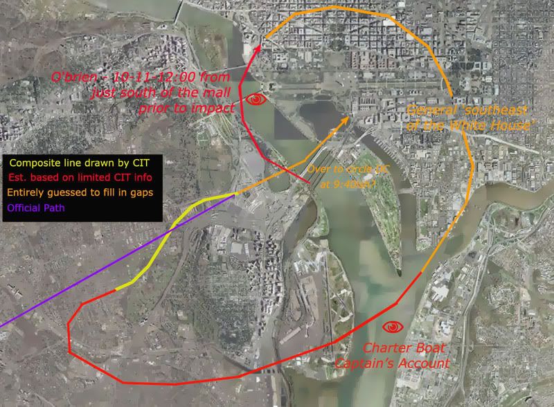
At present then my guess is they have actually placed the C-130 somewhat south of the Capitol. As Craig had earlier said, hinting at a correlation with the Charter Boat Captain on the river south of Reagan National:
"We were always stumped with how O'Brien's account didn't make sense with the 2006 NTSB flight path of AA77 until we talked with our newest witness who was on the Potomac River who reveals that the NTSB flight path is false and that the plane came from the EAST of the river and looped around north timed perfectly with the explosion at the Pentagon!"
[source]
By this mapping above, 77 was looping north and east of the C-130 to NORTH OF THE CAPITOL 'timed perfectly' with the explosion a few miles to the southwest. So I'm left guessing that after all the yammering about how the plane could ONLY be right over the Capitol, that the English language mandates it, that anyone who places it any further south is a dishonest goal-post-moving scumbag... must be qualified. Only CIT is allowed to disregard the words of O'Brien saying "north and west" and a "beautiful view of the mall" to actually be well SOUTH of the mall AFTER ALL, to match up with the loop the Charter Boat Captain describes! The special privileges Citizen researchers afford themselves.
Now I'm unaware of just where the river witness places the flight path, but it's probably not as far south as it would have to be to approach the C-130 as shown on radar. But it is obviously further south than their original 'beautiful view' would necessitate, and shows that O'Brien's account is indeed open to interpretation in CIT's mind, whereas when I had tried to say the same thing as they were INSISTING on the infallibility of that graphic, they said things like this: "Power of suggestion, up is down, left is right, north is south. Lies.” [Craig responding to an incorrect assessment of my video] Or this: "Just because you said it Adam. You can change anything at anytime and it all makes sense. You can say anything, up is down and down is up. I understand.” [Asshole Marquis, both quotes from the LCF thread linked to at top]
So I am "dead wrong" in my direct reading of the same infallible evidence CIT has provided me. So their assessment was wrong. After they insisted it couldn't be. "Up" is "down" now I guess just because they say so, even tho it was a deceptive treasonous scumbag lie at first when I said it.
Duly noted, for the record, yet again... the hypocrisy never stops.
Thursday, November 8, 2007
FARMER C2C INTERVIEW / RADES DATA ALERT
FARMER C2C INTERVIEW / RADES DATA ALERT
Adam Larson / Caustic Logic
The Frustrating Fraud
Nov 8 2007
last update 11/12/1pm
Deserving of special mention at this blog at this time is statistician, video analyst, and Pentagon attack researcher John Farmer. I first encountered his works as cited by Pilot for 9/11 Truth as supporting their silliness – my initial and flippant suspicions about this GOP-oriented conservative Truther ‘expert’ was soon confused at best as I saw him make some really good points and brought some new data and thoughts to the table. In addition to a lot of exceptional, top-shelf analysis, he’s made some bad arguments, some I just don’t get, and others I haven’t read yet, has been embroiled with Citizen’s Investigative Team over their abuse of his evidence, and it seems has let his bridges to the Pilots be burnt down. He was indispensable in helping me to see and analyze the shadow south of the Citgo, although I must note all my findings are my own; that we happen to agree this does not a cabal make.
At any rate, I was excited to hear he’d be interviewed on Coast to Coast AM by host Ian Punnett on Saturday November 3. I didn’t catch it live, but a free audio version is available for a listen here: Select Sunday Nov. 4, 12:00 am; interview starts at 39:15. Requires Windows Media Player.
Punnett seems perhaps suspicious of Farmer as a former cop and oil company “numbers guy” [see site bio] and had earlier played Inner Circle’s Bad Boys in honor of the appearance. Farmer explained how he was initially a non-believer in the theories on 9/11 until hearing about Operation Northwoods a year ago got him thinking. He decided if there were an inside job element, “the Pentagon attack would have to be the one that was controlled […] because [they]’re basically attacking themselves.” Similar control over sources of data was discussed as well as the possibility of official disinformation over the attack to, as Farmer put it, “get certain groups in the Truth Movement fighting each other like cats and dogs over competing theories of what happened.” He should know, of course, after dealing with Rob and Merc and their like.
His discussion on the FDR focused on suspicious statistical trends in lateral acceleration and the issue of the missing end, its last second of data at 9:37:44 pinned down at near the Sheraton Hotel, well over a mile from the Pentagon. From what I can see this seems perfectly correct. He passed on that what seems to be as much as six seconds missing is apparently outside the range of innocent technical error and so the ending would seem deliberately altered. He offered no theory to the exact implications beyond “for some reason there’s some of the data missing.”
84 RADES Alert
Farmer was more excited however to discuss the 84 RADES radar data, compiled by the Air Force’s 84th radar evaluation squadron for the FBI just days after the attacks, that he had just received a copy of on October 5. Trying to draw attention to this new source of information, he plugged for a newly posted video by collaborator Marco Bollettino with animated radar data and NEADS audio overlaid. He lamented that the media doesn’t want to talk about it; he passed the information on it to media outlets that new 9/11 data was available, but only Coast to Coast AM responded.
He also noted that other researchers hadn’t widely looked at it yet. For my part, this new radar info is something I have not dug into yet. To see it first-hand takes special software and to even grasp what others have found takes time. I tend not to post on something unless I feel like a genius on the subject, but since that feeling is usually illusory anyway, here I’d just like to pass along that this info is being looked at and seems fascinating from what I’ve seen. Over the last moth Farmer and others have analyzed the data in detail, locating blips, tracing paths, and identifying aircraft – Langley fighters, the C-130, the E4B, Flight 77, perhaps even its fireball, all seem to appear on radar. Here is a graphic by Bollettino showing last data plot consistent with the flight path at 9:37:12 – when it dropped below radar coverage – and two later returns off the path: one north at 9:37:36, one south at 9:37:48. I’m not sure what’s up with that. Intriguing, no?
---
Update 11/12: Craig Ranke of CIT notes there are reasons to doubt the veracity of the officially-supplied data. Notably, its track of the C-130 cargo plane sent to inspect conflicts with the personal account of C-130 pilot Steve O’Brien. And for that matter, its paths for "Flight 77" and the suspected E4B 'white jet" conflict with existing witness accounts supporting the 'north of the Citgo' path and the down-the-river white jet, if not directly the flyover theory since that all would happen too low to see on radar.
---
Additional Info
84 RADES discussion forum http://bluecollarrepublican.com/rades/viewforum.php?f=4&sid=9b90526526e9d2f132706195d6d392d9
All 911files.info blog posts on radar data
FDR/RADES comparitive study: PDF link
Adam Larson / Caustic Logic
The Frustrating Fraud
Nov 8 2007
last update 11/12/1pm
Deserving of special mention at this blog at this time is statistician, video analyst, and Pentagon attack researcher John Farmer. I first encountered his works as cited by Pilot for 9/11 Truth as supporting their silliness – my initial and flippant suspicions about this GOP-oriented conservative Truther ‘expert’ was soon confused at best as I saw him make some really good points and brought some new data and thoughts to the table. In addition to a lot of exceptional, top-shelf analysis, he’s made some bad arguments, some I just don’t get, and others I haven’t read yet, has been embroiled with Citizen’s Investigative Team over their abuse of his evidence, and it seems has let his bridges to the Pilots be burnt down. He was indispensable in helping me to see and analyze the shadow south of the Citgo, although I must note all my findings are my own; that we happen to agree this does not a cabal make.
At any rate, I was excited to hear he’d be interviewed on Coast to Coast AM by host Ian Punnett on Saturday November 3. I didn’t catch it live, but a free audio version is available for a listen here: Select Sunday Nov. 4, 12:00 am; interview starts at 39:15. Requires Windows Media Player.
Punnett seems perhaps suspicious of Farmer as a former cop and oil company “numbers guy” [see site bio] and had earlier played Inner Circle’s Bad Boys in honor of the appearance. Farmer explained how he was initially a non-believer in the theories on 9/11 until hearing about Operation Northwoods a year ago got him thinking. He decided if there were an inside job element, “the Pentagon attack would have to be the one that was controlled […] because [they]’re basically attacking themselves.” Similar control over sources of data was discussed as well as the possibility of official disinformation over the attack to, as Farmer put it, “get certain groups in the Truth Movement fighting each other like cats and dogs over competing theories of what happened.” He should know, of course, after dealing with Rob and Merc and their like.
His discussion on the FDR focused on suspicious statistical trends in lateral acceleration and the issue of the missing end, its last second of data at 9:37:44 pinned down at near the Sheraton Hotel, well over a mile from the Pentagon. From what I can see this seems perfectly correct. He passed on that what seems to be as much as six seconds missing is apparently outside the range of innocent technical error and so the ending would seem deliberately altered. He offered no theory to the exact implications beyond “for some reason there’s some of the data missing.”
84 RADES Alert
Farmer was more excited however to discuss the 84 RADES radar data, compiled by the Air Force’s 84th radar evaluation squadron for the FBI just days after the attacks, that he had just received a copy of on October 5. Trying to draw attention to this new source of information, he plugged for a newly posted video by collaborator Marco Bollettino with animated radar data and NEADS audio overlaid. He lamented that the media doesn’t want to talk about it; he passed the information on it to media outlets that new 9/11 data was available, but only Coast to Coast AM responded.
He also noted that other researchers hadn’t widely looked at it yet. For my part, this new radar info is something I have not dug into yet. To see it first-hand takes special software and to even grasp what others have found takes time. I tend not to post on something unless I feel like a genius on the subject, but since that feeling is usually illusory anyway, here I’d just like to pass along that this info is being looked at and seems fascinating from what I’ve seen. Over the last moth Farmer and others have analyzed the data in detail, locating blips, tracing paths, and identifying aircraft – Langley fighters, the C-130, the E4B, Flight 77, perhaps even its fireball, all seem to appear on radar. Here is a graphic by Bollettino showing last data plot consistent with the flight path at 9:37:12 – when it dropped below radar coverage – and two later returns off the path: one north at 9:37:36, one south at 9:37:48. I’m not sure what’s up with that. Intriguing, no?

---
Update 11/12: Craig Ranke of CIT notes there are reasons to doubt the veracity of the officially-supplied data. Notably, its track of the C-130 cargo plane sent to inspect conflicts with the personal account of C-130 pilot Steve O’Brien. And for that matter, its paths for "Flight 77" and the suspected E4B 'white jet" conflict with existing witness accounts supporting the 'north of the Citgo' path and the down-the-river white jet, if not directly the flyover theory since that all would happen too low to see on radar.
---
Additional Info
84 RADES discussion forum http://bluecollarrepublican.com/rades/viewforum.php?f=4&sid=9b90526526e9d2f132706195d6d392d9
All 911files.info blog posts on radar data
FDR/RADES comparitive study: PDF link
Monday, July 16, 2007
A SLOW ZOOM ON THE FINAL LOOP
A SLOW ZOOM ON THE FINAL LOOP
Adam Larson / Caustic Logic
The Frustrating Fraud
July 16 2007
last updated July 19
Connecting the Dots
 The initial flight path of hijacked Flight 77, as published in the days after the attacks, was largely a connect-the-dots approach. With no transponder after the terrorist takeover, and, we were told, “limited primary radar coverage” along the attack route, the return flight was not seen for a half-hour until it entered Washington airspace with its own radar. [1] The dotted line estimations published at this point sowed among the first seeds of suspicion over the attack. Was there a swap out there in the blind spot? As more evidence comes to light, all these paths have proven broadly accurate in that the 757 headed west, turned south over the WV-KY-OH border area, lost transponder, and returned, heading East straight to the Pentagon. Of the three maps above, Newsweek’s is the most accurate. USA Today’s path has a pronounced hump giving it a submarine profile, and Time’s map has the plane swooping north on its way back, crossing its outbound flight path, twisting the loop into an infinity symbol.
The final line of the journey as it passed east of its origin at Dulles, seems from here uneventful. But in these same early days reports surfaced of a tight, controlled, implausible loop over eastern Virginia, thought by many beyond the reported skills of the alleged hijacker Hani Hanjour. Facing the west wall, Flight 77 was said to have turned 270°-360° to hit - the west wall – oddly enough, the side just renovated to withstand bombs and impacts, largely empty, and across the building from the Defense Secretary’s Office. [more on the radar blind spot and the impact location in "From the blind spot to the empty side."]
Few if any eyewitness accounts seem to address the grand loop, since it was simply too big to have been seen by any one person – the first part of it was perhaps too high to attract much attention, but as it approached the Navy Annex and continued to lose altitude, it attracted more witnesses in its last several seconds, by which time it was going straight towards the Pentagon’s west wall. With such published accounts as the early cornerstone of our awareness of the attack, this magical loop remained largely invisible, possibly another government lie.
 The overall uncertainty over 77’s approach lead many to accept this flight path as plausible to explain the final loop. It has Flight 77 flying south through DC’s restricted airspace with no White House defensive fire, headed towards Rumsfeld’s office before turning to hit the opposite side of the Pentagon, giving us the 270° turn so often cited. This map is quite wrong, understating the actual degree of turn by 60° and grossly misreading the original heading. [How this old map was arrived at and what’s wrong with it is explained separately in "the "old" 270° loop explained."]
The Radar Record
Among the too-vague early report was this from the ever-unbelievable Vice President Cheney, five days after the attack: "it entered the danger zone and looked like it was headed for the White House [...] Didn't circle it, but was headed on a track into it. [...] It turned away and, we think, flew a circle and came back in and then hit the Pentagon. And that's what the radar track looks like." [2] Five days later CBS News reported “radar shows Flight 77 did a downward spiral, turning almost a complete circle,” after which “the jetliner disappeared from radar at 9:37 and less than a minute later it clipped the tops of street lights and plowed into the Pentagon at 460 mph.” [3]
It was another month before radar specialist Danielle O’Brien, on duty at the Dulles ATC tower on 9/11, told ABC News’ 20/20 “it was an unidentified plane to the southwest of Dulles, moving at a very high rate of speed [...] I had literally a blip and nothing more.” As it headed towards the Pentagon, “it was just a countdown. Ten miles west. Nine miles west […] And it went six, five, four. And I had it in my mouth to say, three, and all of a sudden the plane turned away. In the room, it was almost a sense of relief.” But the turn continued until it was much lower and facing the same direction, after which O’Brien tersely summed up "we lost radar contact with that aircraft [...] and then the Washington National controllers came over our speakers [saying] The Pentagon's been hit.” [4]
O’Brien’s interview, aired in late October 2001, was accompanied by a radar screen graphic with a south loop of near 360 degrees off the east-bound flight as seen on radar screens. Seen briefly by millions, perhaps many thought this arc of dots just a guess or irrelevant, but in fact this same path would prove accurate and come back to bite them in the butt five years later. [Other than the red lettering, this picture is a direct screenshot from the program, viewable here.]

Official Reports: Zooming the Lump
 We were only allowed a slow zoom in on what that loop actually looked like in the chain of official reports. Initial NTSB studies were kept behind closed doors, being in the FBI’s jusrisdiction and exempt from FOIA requirements. But the correct loop is there in a map from the 9/11 Commission’s Final Report, released mid-2004. Note its general agreement with early reports, and also the little lump of ink on the south side of the terminal tip – that’s the final loop, unreadable in this bold line on an unnecessarily zoomed back map. This line is apparently taken from the NTSB’s Flight Path Study, made from FDR and radar data in February 2002, classified at the time but available to the commission and cited in the endnotes. The report explained how at "5 miles west-southwest of the Pentagon," Flight 77 "began a 330 degree turn." [5]
That document was finally released via numerous FOIA requests in August 2006 and posted online from numerous angles. Finally we see a zoom in on the mysterious grand loop [see below]. First we see their overall flight path, printed big enough to show a silly little loop at the end [blue box], and also a detail of the loop all on its own page, faded yellow on a pale orange topo map [red box]. This is labeled in the report as “DC area flight path,” so possibly from ATC radar track, while the overall flight path above it is said to be from the matching FDR/radar data. [6]

The Black Box
Additional Flight Data Recorder information further verifies this loop. The Specilaist’s Factual Report of Investigation (SFRI), is an NTSB documented drawing exclusively on the full Black Box readings, also released in the 2006 rush. It has all functioning parameters graphed out for the duration of the flight, spread out over 17 pages; The basics -altitude, airspeed, and magnetic heading - are reproduced on each page. Here is the clearest extraction I've taken of this, edited to show a zoomed-in final minutes reading. All lines and values are accurate according to the bars at right and left. [7]
 The story it tells is that at 9:34 Flight 77 began a remarkable thhree-minute turn just short of the Pentagon. The change in magnetic heading is graphed - as it approached DC with a general heading of about 95-100° magnetic –after a slight adjustment to the north and back at 9:31-32, the plane begins its loop at 9:34 – for about three minutes it turns south and then near-full circle to the west, north, and finally settling, at about 9:37, on a northeast heading of 70° magnetic, after completing the 330° turn and descending about 4,000 feet in the process, the last 45 seconds were a straight shot at that heading and a steady descent to roughly zero altitude at 9:37:45.
Here is how to read the headings on a map - apologies for the fruit-flavored style if that offends anyone’s sensibilities. The angle and color tells headingat a given mement, tehe direction the nose is pointing. Magnetic heading, which the FDR works with, are just about 10° higher compared to headings based on geographic north, since the magnetic north pole at that time was about ten degrees west of the true north. Read zero also as 360, due north, green. Here the plane starts out deep blue – due east, roughly 90° from north, 100 mag on the FDR - and its final heading is about 60°. Add ten to get magnetic, and this is what the FDR says – 70°.

The erred NTSB working copy animation, used by Pilots for 9/11 Truth, matches as well the official loop; their “final maneuver” video starts out at 9:34:03, turn just starting, and straightening out from 9:36:45-9:37:15 The onscreen mag heading dial roughly matches the other FDR data, settling on 70 after the loop – but of course the on-screen animation somehow ends up twenty degrees off from that, which is what places it “too far to the left” to have impacted the Pentagon, as the Pilots discovered…
Sources and editing: Coming
[1] Phillips, Don. “Pentagon Crash Highlights a Radar Gap.” Washington Post. November 3, 2001. Page A06. http://www.washingtonpost.com/ac2/wp-dyn?pagename=article&contentId=A32597-2001Nov2¬Found=true
[2] "The Vice President appears on Meet the Press with Tim Russert." Camp David, Maryland. September 16 2001. http://www.whitehouse.gov/vicepresident/news-speeches/speeches/vp20010916.html
[3] "Primary Target - THE PENTAGON." CBS News. September 21 2001. http://www.cbsnews.com/stories/2001/09/11/national/main310721.shtml
[4] "`Get These Planes on the Ground' - Air Traffic Controllers Recall Sept. 11," ABC News, October 24 2001. http://web.archive.org/web/20011024150915/http://abcnews.go.com/sections/2020/2020/2020_011024_atc_feature.html
[5] National Commission on Terrorist Attacks Upon the United States. The 9/11 Commission Report. map: p. 33. Citation of Flight Path Study: Page 459, source 59 for chapter 1. Explanation of the loop on page 9.
[6] FPS
[7] Specialist’s Factual Report of Investigation: Digital Flight Data Recorder . NTSB document number: DCA01MA064 National Transportation Safety Board, Vehicle Records Division. January 31 2002. PDF download link: http://www.ntsb.gov/info/AAL77_fdr.pdf
Adam Larson / Caustic Logic
The Frustrating Fraud
July 16 2007
last updated July 19
Connecting the Dots
 The initial flight path of hijacked Flight 77, as published in the days after the attacks, was largely a connect-the-dots approach. With no transponder after the terrorist takeover, and, we were told, “limited primary radar coverage” along the attack route, the return flight was not seen for a half-hour until it entered Washington airspace with its own radar. [1] The dotted line estimations published at this point sowed among the first seeds of suspicion over the attack. Was there a swap out there in the blind spot? As more evidence comes to light, all these paths have proven broadly accurate in that the 757 headed west, turned south over the WV-KY-OH border area, lost transponder, and returned, heading East straight to the Pentagon. Of the three maps above, Newsweek’s is the most accurate. USA Today’s path has a pronounced hump giving it a submarine profile, and Time’s map has the plane swooping north on its way back, crossing its outbound flight path, twisting the loop into an infinity symbol.
 The final line of the journey as it passed east of its origin at Dulles, seems from here uneventful. But in these same early days reports surfaced of a tight, controlled, implausible loop over eastern Virginia, thought by many beyond the reported skills of the alleged hijacker Hani Hanjour. Facing the west wall, Flight 77 was said to have turned 270°-360° to hit - the west wall – oddly enough, the side just renovated to withstand bombs and impacts, largely empty, and across the building from the Defense Secretary’s Office. [more on the radar blind spot and the impact location in "From the blind spot to the empty side."]
Few if any eyewitness accounts seem to address the grand loop, since it was simply too big to have been seen by any one person – the first part of it was perhaps too high to attract much attention, but as it approached the Navy Annex and continued to lose altitude, it attracted more witnesses in its last several seconds, by which time it was going straight towards the Pentagon’s west wall. With such published accounts as the early cornerstone of our awareness of the attack, this magical loop remained largely invisible, possibly another government lie.
 The overall uncertainty over 77’s approach lead many to accept this flight path as plausible to explain the final loop. It has Flight 77 flying south through DC’s restricted airspace with no White House defensive fire, headed towards Rumsfeld’s office before turning to hit the opposite side of the Pentagon, giving us the 270° turn so often cited. This map is quite wrong, understating the actual degree of turn by 60° and grossly misreading the original heading. [How this old map was arrived at and what’s wrong with it is explained separately in "the "old" 270° loop explained."]
The Radar Record
Among the too-vague early report was this from the ever-unbelievable Vice President Cheney, five days after the attack: "it entered the danger zone and looked like it was headed for the White House [...] Didn't circle it, but was headed on a track into it. [...] It turned away and, we think, flew a circle and came back in and then hit the Pentagon. And that's what the radar track looks like." [2] Five days later CBS News reported “radar shows Flight 77 did a downward spiral, turning almost a complete circle,” after which “the jetliner disappeared from radar at 9:37 and less than a minute later it clipped the tops of street lights and plowed into the Pentagon at 460 mph.” [3]
It was another month before radar specialist Danielle O’Brien, on duty at the Dulles ATC tower on 9/11, told ABC News’ 20/20 “it was an unidentified plane to the southwest of Dulles, moving at a very high rate of speed [...] I had literally a blip and nothing more.” As it headed towards the Pentagon, “it was just a countdown. Ten miles west. Nine miles west […] And it went six, five, four. And I had it in my mouth to say, three, and all of a sudden the plane turned away. In the room, it was almost a sense of relief.” But the turn continued until it was much lower and facing the same direction, after which O’Brien tersely summed up "we lost radar contact with that aircraft [...] and then the Washington National controllers came over our speakers [saying] The Pentagon's been hit.” [4]
O’Brien’s interview, aired in late October 2001, was accompanied by a radar screen graphic with a south loop of near 360 degrees off the east-bound flight as seen on radar screens. Seen briefly by millions, perhaps many thought this arc of dots just a guess or irrelevant, but in fact this same path would prove accurate and come back to bite them in the butt five years later. [Other than the red lettering, this picture is a direct screenshot from the program, viewable here.]

Official Reports: Zooming the Lump
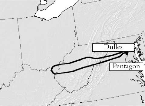 We were only allowed a slow zoom in on what that loop actually looked like in the chain of official reports. Initial NTSB studies were kept behind closed doors, being in the FBI’s jusrisdiction and exempt from FOIA requirements. But the correct loop is there in a map from the 9/11 Commission’s Final Report, released mid-2004. Note its general agreement with early reports, and also the little lump of ink on the south side of the terminal tip – that’s the final loop, unreadable in this bold line on an unnecessarily zoomed back map. This line is apparently taken from the NTSB’s Flight Path Study, made from FDR and radar data in February 2002, classified at the time but available to the commission and cited in the endnotes. The report explained how at "5 miles west-southwest of the Pentagon," Flight 77 "began a 330 degree turn." [5]
 That document was finally released via numerous FOIA requests in August 2006 and posted online from numerous angles. Finally we see a zoom in on the mysterious grand loop [see below]. First we see their overall flight path, printed big enough to show a silly little loop at the end [blue box], and also a detail of the loop all on its own page, faded yellow on a pale orange topo map [red box]. This is labeled in the report as “DC area flight path,” so possibly from ATC radar track, while the overall flight path above it is said to be from the matching FDR/radar data. [6]

The Black Box
Additional Flight Data Recorder information further verifies this loop. The Specilaist’s Factual Report of Investigation (SFRI), is an NTSB documented drawing exclusively on the full Black Box readings, also released in the 2006 rush. It has all functioning parameters graphed out for the duration of the flight, spread out over 17 pages; The basics -altitude, airspeed, and magnetic heading - are reproduced on each page. Here is the clearest extraction I've taken of this, edited to show a zoomed-in final minutes reading. All lines and values are accurate according to the bars at right and left. [7]
 The story it tells is that at 9:34 Flight 77 began a remarkable thhree-minute turn just short of the Pentagon. The change in magnetic heading is graphed - as it approached DC with a general heading of about 95-100° magnetic –after a slight adjustment to the north and back at 9:31-32, the plane begins its loop at 9:34 – for about three minutes it turns south and then near-full circle to the west, north, and finally settling, at about 9:37, on a northeast heading of 70° magnetic, after completing the 330° turn and descending about 4,000 feet in the process, the last 45 seconds were a straight shot at that heading and a steady descent to roughly zero altitude at 9:37:45.
 Here is how to read the headings on a map - apologies for the fruit-flavored style if that offends anyone’s sensibilities. The angle and color tells headingat a given mement, tehe direction the nose is pointing. Magnetic heading, which the FDR works with, are just about 10° higher compared to headings based on geographic north, since the magnetic north pole at that time was about ten degrees west of the true north. Read zero also as 360, due north, green. Here the plane starts out deep blue – due east, roughly 90° from north, 100 mag on the FDR - and its final heading is about 60°. Add ten to get magnetic, and this is what the FDR says – 70°.

The erred NTSB working copy animation, used by Pilots for 9/11 Truth, matches as well the official loop; their “final maneuver” video starts out at 9:34:03, turn just starting, and straightening out from 9:36:45-9:37:15 The onscreen mag heading dial roughly matches the other FDR data, settling on 70 after the loop – but of course the on-screen animation somehow ends up twenty degrees off from that, which is what places it “too far to the left” to have impacted the Pentagon, as the Pilots discovered…
Sources and editing: Coming
[1] Phillips, Don. “Pentagon Crash Highlights a Radar Gap.” Washington Post. November 3, 2001. Page A06. http://www.washingtonpost.com/ac2/wp-dyn?pagename=article&contentId=A32597-2001Nov2¬Found=true
[2] "The Vice President appears on Meet the Press with Tim Russert." Camp David, Maryland. September 16 2001. http://www.whitehouse.gov/vicepresident/news-speeches/speeches/vp20010916.html
[3] "Primary Target - THE PENTAGON." CBS News. September 21 2001. http://www.cbsnews.com/stories/2001/09/11/national/main310721.shtml
[4] "`Get These Planes on the Ground' - Air Traffic Controllers Recall Sept. 11," ABC News, October 24 2001. http://web.archive.org/web/20011024150915/http://abcnews.go.com/sections/2020/2020/2020_011024_atc_feature.html
[5] National Commission on Terrorist Attacks Upon the United States. The 9/11 Commission Report. map: p. 33. Citation of Flight Path Study: Page 459, source 59 for chapter 1. Explanation of the loop on page 9.
[6] FPS
[7] Specialist’s Factual Report of Investigation: Digital Flight Data Recorder . NTSB document number: DCA01MA064 National Transportation Safety Board, Vehicle Records Division. January 31 2002. PDF download link: http://www.ntsb.gov/info/AAL77_fdr.pdf
Subscribe to:
Posts (Atom)


