Showing posts with label P49T. Show all posts

Sunday, June 1, 2008

THE FLIGHT DATA RECORDER {masterlist}

A BLACK BOX SURROUNDED BY A MOAT OF MYSTERY
Adam Larson
Caustic Logic / The Frustrating Fraud
last update 8/24/07
Last updated 3/4/08


Much Ado About... Nothing?

Much has been made recently of the reconstruction of data from Flight 77’s Flight Data Recorder, the so-called black box found at the crash scene inside the Pentagon. The "9/11 Truth" analysis of the data is largely based on the fragmentation of the supposedly coherent data in the flight data recorder (FDR) of the attack plane – different versions have appeared, between which different parameters are found to be "altered," leaving each piece neither totally false and dismissable nor totally true and acceptable. Thus they hover in a middle space to be analyzed by experts – primarily Pilots for 9/11 Truth and their expert allies. Predictably, the data as read and shared offers different answers to different questions at different times, depending it seems on the circumstance. The answers consistently challenge the official account, but fail to prvide a rational alternative, and often conflict with each other…

Various aspects of the NTSB animation based partly on the FDR are covered in my three-part video series "That Darn NTSB cartoon," compiled with notes here.

--- About the Sources ---
- The Evidence Trail - NTSB, FBI, 9/11 Commission, and the National Security Archive keeping the data under wraps, and its final revalation to the public in mid-2006.

- The FDR Specialist's Study: A closer look at the verifiably NTSB-provided FDR data.

- The CSV file

- "Three CD's: Where's Snowygrouch's DVD?" The Pilots' Transatlantic animation connection examined. Snowygrouch and the animation's first appearance. NTSB status at the time: unclear IMO, and yet...

--- Analysis ---
- Pilot X and the 440-foot gap: Altitude Questions raised by the NTSB animation

- Created in Translation: the altitude re-set NOT in the animation - where is it then? at FL018... forthcoming

- A somewhat dated but interesting analysis thread by myself and others @ Above Top Secret: Great insights, explanations, obfuscation, and fumbling with appearances by John Lear, John Doe X, and others.

- Ten Degrees From true: THE "NTSB Animation" is Flat Wrong Demonstrating that the north of the Citgo flight path shown is in fact at least 20 degrees off from the Black Box data it's supposed to be based on.

- Final Altitude: Eight Readings: At least four altitudes attributed the the FDR, compared to flyover "witnesses," and the "official story." I did forget radar accounts which place altitude by accounts of it dropping beneath their coverage just before impact. This is said to confirm the official story and probably does.

- 20 Minutes and 20 Miles from True: CSV longitudinal offset

- NTSB animation internal geography {masterlist} My most tedious chapter yet - five posts with one or two more to come.
- A Turn For The Worse: The culmination of the animation studies above: visual proof that the animation's final overlay map is rotated to about the same tune the plane appears north-of-the-Citgo.

- Csv/animation altitude discrepancy. Kind of a mess, mostly intended as a self-correction.

- CSV final plots: Using timeline seconds to determine geographic seconds.

- Missing Seconds: My Last FDR post

- Bank Notes: Draws on FDR bank/roll readings as part of a larger argument

--- My own NTSB FOIA Search ---
- News Coming A half-ass rundown of why I was finally contacting the NTSB.

- NTSB FOIA Response recieved - no discs enclosed

- NTSB's "Goebbels" and Me When I talked to the director - not important but a tad interesting

- Video: That Darn NTSB cartoon part 2 - the Authenticity Sidetrack Snowygrouch et al. and my discless response explained by me in a video.

Tuesday, March 18, 2008

OBSTACLE? IMPOSSIBLE.

OBSTACLE? IMPOSSIBLE.
WHY THIS ANTENNA THING IS A NON-ISSUE
Adam Larson / Caustic Logic
The Frustrating Fraud
March 18 2008
last update 3/23 3am


Okay, so here’s my response to Rob Balsamo’s new masterpiece Arlington Topography, Obstacles Make American 77 Final Leg Impossible. Yet again, we hear, some things taken together with other things have again proven the official story of the Pentagon attack is physically impossible. He dated the piece March 13 so he could say dramatically “"Beware The Ides Of March" could not be a more appropriate introduction to this article as it appears the government story regarding the events at the pentagon is officially dead.” Again the merry-go-round spins and in the end… again…. everyone disagrees still. I weary of this game, and this latest seems really a pathetic attempt. But it is in my area and people have asked my opinion, so I guess I need to cover it.

After infinite CIT re-posts of Pilots for Truth misfindings, it seems it was Rob Balsamo’s turn to catch them back. “Thanks to the hard work done by Citizen Investigation Team, they alerted us to review figures regarding topography and obstacles along the flight path of American 77 according to the government story. […] According to the government, American 77 final approach to the pentagon is depicted below.”
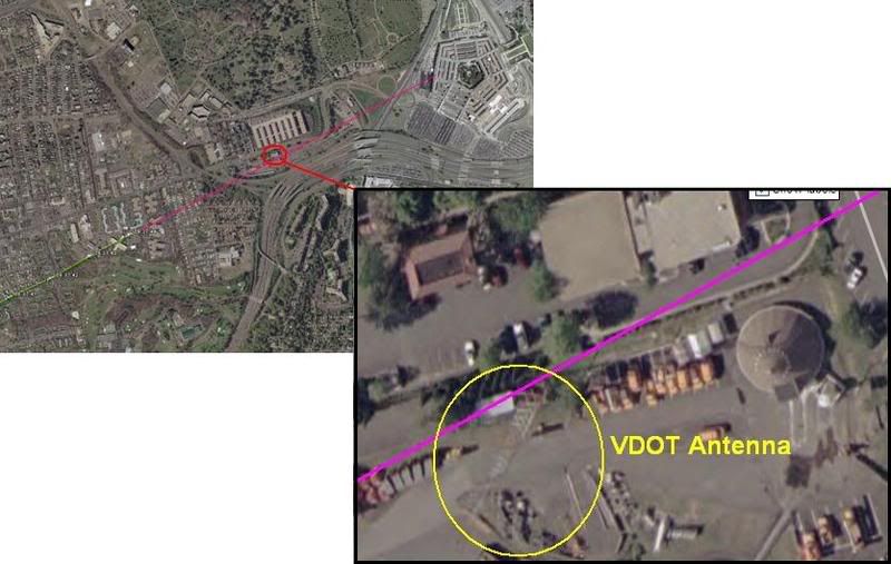
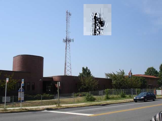
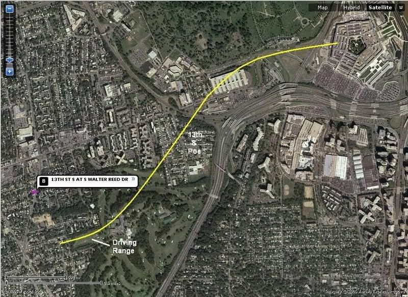
This graphic is not produced by the government, but by Merc Mercy CIT. I’m sure it’s fairly close to accurate, but is it close enough to say where the plane was relative to this 5-foot wide ‘obstacle?’ I’d have to say no. But Balsamo acts as if the government had drawn the line that took the plane right into or over this VDOT transmitter tower, 169 ft tall (including 6-foot antennas on top) above a ground elevation of 135 feet. He never explains whether or not this tower WAS hit, just takes a point right above it as a starting point. From this he did a bunch of math, with too many steps it seems to me, and decided that such a descent from above the tower to the light poles and into the building level would require 11.2 Gs of force.

“Conclusion = Impossible for any transport category aircraft to descend from top of VDOT Antenna to top of pole 1 and pull level to "impact hole" as reported by the government story and seen in the DoD "5 Frames Video". 11.2 G's was never recorded in the FDR. 11.2 G's would rip the aircraft apart.”

I don’t intend to get into the math of all this, but John Farmer’s response is worthy of note: Mission impossible He found that Balsamo’s numbers didn’t add up to what he said they did, double-checked and found the g-force would be 3.5, not 11.2. “So “impossible” is not the word I would use Rob.”

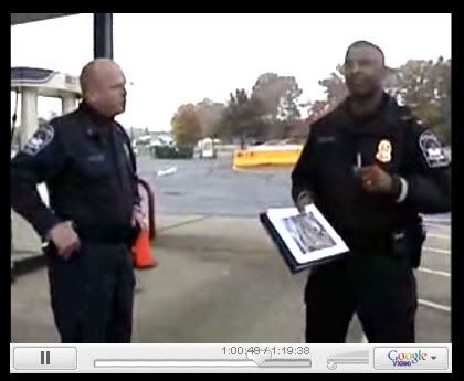
Then he also passed on the video interview of witness Ed Paik explaining how the antenna on top was indeed damaged. Somehow this was not included in Balsamo’s post even though his sources were there when Paik said this. Ranke had to add after that indeed Paik said this but, as Ranke explained back in 2006 “he just deduced this because he saw them working on it the next day. We confirmed with the VDOT employees that the antenna was not clipped.”

This maintenance was routine then, and just happened to occur one day after the plane flew right over it. Says CIT. Perhaps… But doubts remain; the only photo anyone’s yet found that shows the tower on 9/11 after the strike, by Steve Riskus, shows some hints of a damaged antenna, as Farmer discovered. I can see this, the deformation of the shorter right spire, and it's an intriguing possibility; as Arabesque puts it:

""We have a plane that many witnessed flying by the area the previous day. We have the flight data recorder suggesting that the plane might very well have been in line to hit the top of the tower and continue its trajectory; impacting the light poles and the Pentagon. We have a witness who confirms that the plane was flying at the approximate height of this tower and that he suspected that it was damaged from an impact with the plane as it was being repaired the next day--the two meter antenna replaced by a repair-man. If it can be proven that the tower was damaged from the incoming plane, this would be another compelling piece of evidence for the south of CITGO gas station approach and impact into the Pentagon; corroborated by the flight data recorder no less.""[e-mail]

However, this photo is just not clear enough for me. It’s essentially a needle in the distance, lost in a digital haystack. Any slight artifact will warp it too easily. In fact when people were TRYING to take a good picture in 2006, it almost looks like one antenna is missing entirely (below). I don’t think we’ll ever see a picture clear enough to say unless it was taken by the repairman, but I'd need to see better evidence it was NOT damaged before I'd believe that either (a copy of the work order for 9/12 stating the reason for the repair, for example). I’m leaving this aspect ambiguously undecided and moving on.
Whether the plane flew just over this spindly 'obstacle' or nicked its top, the descent issues are roughly the same - a descent from 305ft MSL to about 35-40, a total non-linear descent of 270 feet over a span of about 3400 feet. This means a descent of 165 feet from FDR last frame before the antenna and another app. 235 feet dropped from the antenna to the first light pole in the same rough distance but at higher speed. I'm no pilot, but a lower altitude at the tower makes a bit more sense.

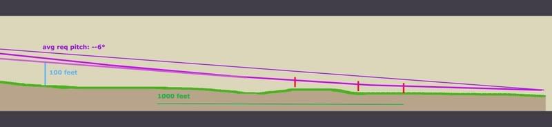
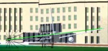
For a different aspect on aircraft height, Terry Morin at the Navy Annex (aka FOB) placed the Boeing “essentially right over the top of me and the outer portion of the FOB (flight path parallel the outer edge of the FOB). Everything was shaking and vibrating, including the ground. I estimate that the aircraft was no more than 100 feet above me (30 to 50 feet above the FOB) in a slight nose down attitude.” For this I’ll us a graphic I used earlier when CIT argued a similar problem relating to descent angles and impossible stuff, just updated a bit. It’s a panoramic graphic so here’s the right half with a reasonable descent angle to the light poles and impact.

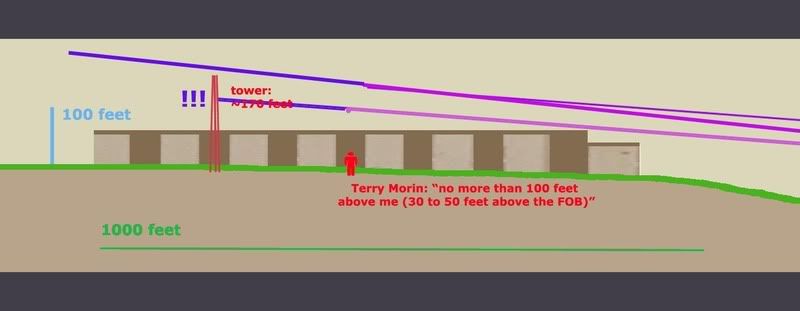
And here is the important half, with the tower added to scale and cross-sectional placement. Oddly, my previous lines extended back take it over the tower neatly, but that’s a pretty steep descent. It looks like it would cause 3.5-11.2 Gs, considering the range offered so far. If we take Morin’s account as closer, which I tend to, it had to be much lower, which offers a more reasonable pitch, but takes the plane well below the top of the tower. This means an impact if Merc’s government line is accurate.

But I doubt it is. Flight paths aren't perfectly straight. They wiggle a bit, especially I would think at high speeds in the lower atmosphere. In another post I established that the witness record and physical damage best fits with a moderate left bank over the Navy annex, and likely a slight left curve to the flight path between the Navy Annex and Route 27 where it leveled slightly, with an apparent left bank of about –5-6° evident in the impact damage.

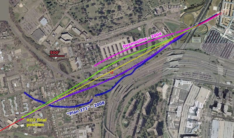
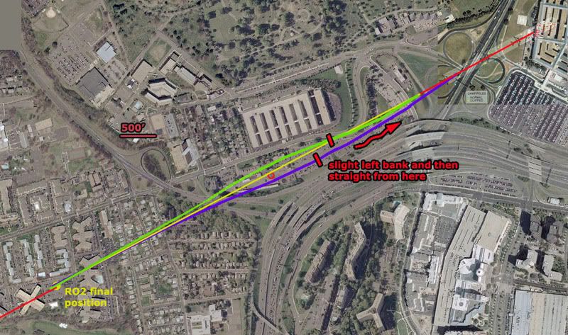
So considering all we know here is a proposal I offer: I had first favored the purple swerve, but after reviewing Morin I'm betting on the green line at the moment, or else the purple one.
- Final trajectory by pole and building damage - ≈ 61°
- Final FDR heading ≈ 59.9° (these are shown in red at the corners).
- The big yellow dot at lower left is the last reported position in the FDR data we have
- The yellow line a straight shot from there to the damage path. This indeed crosses over or within a few feet of the tower, probably too close for comfort if it weren’t high enough.
Before going graphically away from straight lines, I added for comparison two non-straight attempts to explain the ‘official’ evidence. In magenta a 2004 estimate by Jean-Pierre Desmoulins with a notable wiggle to it. He’s a pilot. Also in dark blue is an estimate by “Plan 271,” based on eyewitness reports from Dawn Vignola.

The two variations I’ve traced in green and purple are the most moderate explanations. While the green path fits best with Morin's account, the purple one is perhaps more consistent with left bank clues. Note the scale here – 500 feet is just a short line - and that each path is traced along the fuselage centerline. To clear the tower north or south it need only pass 62 feet away (124-foot wingspan). On closer inspection they pass about 250 feet from the tower, so I could’ve made them much milder. In fact I'm thinking the best fit is about 1/3 from the yellow line to the green one, with perhaps a left turn starting earlier, just after the tower, giving it a noticeable left tilt as it approached Route 27.

But even this extreme, both visibly look possible and reasonable – connecting two nearly identical trajectories with a gentle curve away and back, and still safely north or south of the tower. Altitude options open up. Either way, it looks like a reasonable avoidance procedure of a minor object on the attack path. if it were that low, which the witnesses and FDR seem to indicate.

Purple swerve - Max angle required to avoid the tower ≈ 68°
Min angle required to avoid the tower ≈ 53°
Green swerve - about the same
Time frame: app 6-7 seconds from the yellow dot
Any pilots? How impossible is that?

This is a non-issue – a needle of an obstacle that would be missed almost by definition if the path were anything other than perfectly straight, which it probably was. It’s also a non-issue because all previous attempts to ‘prove the official story impossible’ have failed under the test of verification. All that’s happening here is the wrong data being looked at the wrong way and attributed back to reality in a repeated straw man maneuver that’s giving many a case of hay fever. There is nothing impossible about what happened, and as a relative non-issue that seems prohibitively tedious to either prove or debunk I’m not even taking this one to the forums.
Update 3/23:
I took it to the forums a little. 9/11 Blogger (comments page 2) - Above Top Secret.com

update 3/19:

note: in the graphic above I somehow screwed up the 500' scale, making it actually represent about 400 feet. Luckily my margin was still wide enough that these mild swerves are still a fit, both passing well over 100 feet from the antenna tower.

update 3/21:
I just located again Russell Pickering's take on Paik's antenna memories from the old old LCF, 9/10/06:

"I went to the VDOT to confirm it hadn't been hit. It had not. Then in Edward's interview I asked him if he actually saw it hit the tower and he said no. Then I asked him if it hit the solid metal part of the tower and he said no. What he said was that it hit a smaller antenna of 2-3 meters in length on the top. He ended up telling us the reason he thought it had been hit was because he saw somebody up on the tower working the next day.

What had happened then is he incorporated a conclusion from something he saw later into his memory of the original account. The real story is that when the FBI took over the VDOT as a command post they added antennas to the tower for communication."
[emph. mine]

So it actually was not a coincidence people were up there the day after a plane flew by there. There was a direct cause and effect relationship between the two, as that plane had turned the area into a major hurking crime scene of the utmost national security importance. They needed many things, including communications. And perhaps the old antenna was also coincidentally damaged by the plane and replaced at the same time. That certainly can't be ruled out and in fact may well be the case judging by the new evidence coming to light. And that would certainly be another problem for the north path fly over story.

Update 3/23: CIT's take was not coincidence of antenna work but rather that it was not damage-related. They seem the feel it was the military, not the FBI, who put up the new antenna. And we have further confirmation that it was not damaged: John Farmer has confirmed the fact again with the VDOT smart center manager. He offered no details beyond "that was not true!," but as Farmer noted "if anyone should know it would be him (he would have to approve the replacement cost since he was the manager)." [e-mail]

Sunday, March 2, 2008

BANK NOTES

BANK NOTES
Adam Larson / Caustic Logic
The Frustrating Fraud
February 15 2008
updated 2/26 2am


Do You Even Know What A Bank is? Just Curious.
- Craig Ranke: "The plane banked over the Navy Annex [...] Did you know that even Mike Walter claims the plane banked?"
- Craig Ranke: "a bank in his view AT ALL completely destroys the official story."
- Aldo Marquis: "Ever speak to Mike Walter about seeing the plane in a bank? Just curious."
[source for both]

He asks because they did speak to Walter about the bank! At JREF back in April 2007 Ranke (as Lyte Trip) posted this text and graphic:
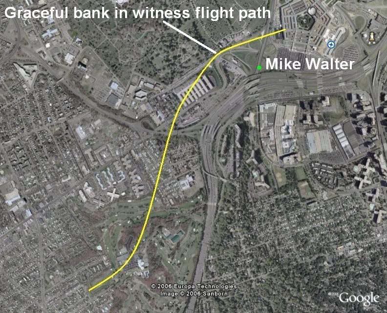
"He contradicts the official flight path. He claims he saw the plane do a "graceful bank" before gaining speed and flying into the building. There would be no "bank" in the official fllight path whatsoever that he could possibly see on route 27. But there most certainly IS a bank in the eyewitness flight path that we report!" [emph mine]
So Mr. Trip and his fellow citizen would have us believe that in the 'official story' "there would be no "bank" [...] whatsoever that he could possibly see on route 27." This is flat false. To understand what's up with this I need to clarify some confusion/conflation. To some minds a 'bank' is indistinguishable from a 'turn,' but a turn, as we all know, is a general changing of direction, while bank is:

"The angle between the wings and the horizon, as viewed from the rear of the airplane. An airplane with its wings level has zero degrees of bank. [...] Banking makes the plane turn. [...] This process is also called Roll." [source]

There is a natural, inevitable correlation between the two; usually banking means a turn just like smoke means a fire. However, just as smoke and fire are two different things, so are these two, and they can in fact be separated. A quick scan of anecdotal evidence - googling "bank without turning" and variations for about two hours - shows that its possible, and involves countering the tendency to turn using the rudder. In fact the rudder seems to be the key to both turning without banking and banking without turning. The best explanation I found is this, by Peter Sagar.

So when someone describes a plane 'banking,' they could possibly mean it colloquially as a turn, or they could mean - well, a bank of the wings, depending on the witness. This is a very important point to remember as we progress here, and when reading the analysis of Ranke and Marquis of Citizen Investigation Team, who make no such distinction. When they hear or say 'bank' they think or mean a turn, and refer to actual bank as 'tilt'. I've never heard them discuss tilt that I can recall, just bank, of course meaning turn. [explanation extracted here]

Discerning then the difference between the angle of a plane's wings and a general change of direction over space, let's address the normal relation between the two. If the right wing goes up, the left wing goes down, and the airplane is said to be in a bank to the left, and will naturally turn to the left. Any kid who zooms around on a bike will understand the concept. There are certainly formulas for bank/turn ratios, but in general, a level plane will go straight, and the steeper the roll, the tighter the resultant turn. How it's measured is seen from behind - right wing low is a positive number, and right high is a negative number. The tilt is measured in degrees, with level wings being 0 and wings straight up-and-down (plane sideways) being 90 degrees. Airliners try to stay level - a bank of 40 degrees is considered extreme, remarkable, rarely-seen, memorable, etc... Please keep this in mind.

Official Bank?
As CIT point out, the official story delivers a straight-shot path, about 70 degrees magnetic, 60 real, for at least two miles prior to impact. Therefore, any bank angle in the final stretch would be slight, or otherwise offset to keep straight. 'Straight' in this case is relative - the path may have had a slight bow that was not noticeable on the small scale most people saw it on. So in CIT terms, a straight line means no bank, and no bank probably means no tilt.

While there is no discernible turn in the official version of the final stretch, CIT will be saddened to learn that there is a bank [tilt] in the 'official story,' recorded in the physical evidence. A roll of about -6 degrees is evident in the wing prints at the facade impact point (IMO a bit more level and a few feet higher than shown here - ASCE graphic measured by me). This bank is generally consistent with the right-left damage before impact: the VDOT camera pole, tree damage, three light poles, diesel generator, etc. encountered by the right wing and engine at their respective heights, and two light poles, vent structure, trailers, and building foundation encountered by the left wing and engine. Though exact numbers are hard to deduce and the minutiae hotly debated, it's all consistent with a slight left bank like that shown here.

Due to the confusion over terminology, and other factors, debating this issue with CIT has been baffling, as they flatly state 'so-and-so wasn't in a position to see the bank,' etc. Couldn't see the bank? For God's sake, I railed... here's their own flyover animation: If I were right there being fooled by the flyover, nothing could fool me about its bank – about zero, perfectly level. So to be clear, they mean 'turn' in these cases and it makes sense that few witnesses would see a whole turn on the scale of even their tight yellow swerve. But since a turn is a change from one heading to another, and marked by a wing tilt as they call it, their recent eagerness to deny witnesses can see headings at all and their silence on 'tilt' are troubling. This leaves their findings very vague - and malleable.

FDR Insights
The numbers recorded for 'roll' in the original CSV file readout of the flight data recorder obtained by Pilots For Truth and others are instructive in what to expect in the last moments as far as turn and tilt. This quick list shows key points before and during its final turn (9:34-9:37, a right bank for nearly a full circle) and end of data:
h:mm:ss - roll
9:32:55 – +3.5
9:33:46 – +1.1
9:34:01 – +8.1
(nearly 8 degrees change in one second! The loop starts here.)
9:34:38 – +29.5
9:35:55 – +37.6
9:36:32 – +16.9
9:37:10 – +10.9
9:37:20 – +2.8
9:37:30 – +3.2
9:37:35 – +2.1
9:37:40 - -0.4
9:37:41 - -0.7 (-0.3 change/sec)
9:37:42 - +1.1 (+1.8 change)
9:37:43 - +3.5 (+2.4)
9:37:44 - +6.3 (+2.8)
[note: C-130 pilot Steve O'Brien estimated the plane's bank as he passed it as 30-40 degrees. By radar he passed it around 9:35-9:36. See above for comparison.]

At 9:37:36 the magnetic heading first hits 70.0 degrees and thereafter is steady, alternating between 70.0 and 69.6. Roll at that time is nominal and then shifting even to a slight left bank, back to right near the end, and then what? A final reading of 6.3 would mean right wing was tilted down to about the same degree the physical evidence has it tilted up, as Pilots For 911 Truth have celebrated. But the FDR is no help in this area – it stopped recording, or was truncated, or something, shortly before that point, somewhere in the neighborhood of 6-8 seconds shy of impact, which would have been around 9:37:50-55. With 12-13 degrees change required that’s about 2 degrees/sec or less, which fits previous trends quite reasonably. But this is all guess work... the machine is silent, and we have the physical evidence and the eyewitnesses, one of which we've covered.

Eyeballs on Wings
So in establishing turns, even if we're calling them banks, it's important to note the direction of the bank. The CIT witness-adduced swerve is shown above in yellow, to scale with the 'official' loop in green recorded by FDR and radar from 9:34-9:37. Check the sample rolls above at these times, and realize the CIT swerve would require a sharp left turn over the driving range, in excess of 40 degrees, a rapid correction, then an equally sharp right turn over the Navy Annex, so a right bank, with left wing very high.

One witness CIT is very excited about, Sean Boger, with a prime view from the heliport, does seem to describe this: "As he was coming towards me it just seemed like he was tilting the aircraft to his right." Barring some confusion (tilted meaning up or down? His right or the plane's?) this sounds great. But he also puts the plane north of the Citgo, so a grain of salt is in order. I also note that as an aviation pro, Boger might've been expected to use the proper term bank, but instead chose the more vague 'tilt' which CIT settled on, as supporting the plane's right... bank.

Which it would, of course. Right tilt-bank means right bank-turn, and this is supported by others in conflict with the official story. Like Mike Walter we hear. LCF part-time member Bileduct calling CIT on using Walter's banking report: bileduct perma-banned, thread closed. In this well-managed thread, Bileduct ejaculated: "You have indicated that Mike Walter described the plane in a banking maneuver over the Navy Annex. Your exact words were "He described the bank in detail to me, Aldo, Dylan, and Russell." My question for you... Did he say the plane banked to the left or the right?" To this simple question Craig responded "To be honest I don't remember. […] But I do recall that he had the plane making a "graceful bank" as it approached, not directly in front of him." Bileduct gloated for a moment then posted one of Walter's published accounts:

"I will never forget that day, trapped in traffic and then I rolled down the window and heard the sound of the jet overhead. [...] I looked up and saw the underbelly of the jet as it gracefully banked, then I watched in shock as the jet basically lined up the Pentagon in its sights and began to scream towards the mammoth structure." [emph mine]

'Underbelly' means it was above him - obviously - and also tilted at least somewhat right wing high. This is a left bank, not a right one, in which case its belly would be turned away. And that this happened in the distance - where the hairpin tirn to the right was supposed to be happening - was doubly troubling. Craig quickly responded "I do not believe or trust Mike Walter for a single second and we have plenty of evidence to show deliberate contradictions in his account. [...] He could not see the underbelly. He did not see the underbelly. He could not have seen the underbelly or a bank on the official flight path as well. This is just ONE of many fatal contradictions demonstrating how Mike Walter's statements are not truthful." Oh, and the tilt-bank wasn't necessarily OVER Route 27 [he doesn't describe it there - abbsence of description = description of absence]. Though the building damage shows a left bank still evident AFTER the road.

So what do other witnesses in the area say?

- Anderson, from far to the north and high up: "I watched in horror as the plane flew at treetop level, banked slightly to the left, drug it's wing along the ground and slammed into the west wall of the Pentagon exploding into a giant orange fireball."
- Elgas, same basic position as Walter, facing north on 27: "The plane just appeared there, very low in the air, to the side of (and not much above) the CITGO gas station that I never knew was there. […] I saw the plane coming in slow motion toward my car and then it banked in the slightest turn in front of me, toward the heliport [...] It was far enough in front of me that I saw the end of the wing closest to me [right] and the underside of the other wing [left] as that other wing rocked slightly toward the ground." She cites a turn, using the word bank!
- Elliot, south-southeast of impact, watched it for several seconds: "I looked to my left and saw the plane coming in [...] It was banking and garnering speed."
- Hagos, on Columbia Pike (?): "It was tilting its wings up and down like it was trying to balance."
- Hemphill, at the east end of the Navy Annex, perfect view: "He was slightly left wing down as he appeared in my line of sight, as if he'd just "jinked" to avoid something. As he crossed Route [27] he appeared to level his wings, making a slight right [wing low] adjustment."
- Marra (on I-395 south of impact?): "The plane rolled left and then rolled right. Then he caught an edge of his wing on the ground." [which wing is unclear]
- Morrin, outside Navy Annex, under its path, plane dipping too low to see]: "I could now only see the tail of the aircraft. I believe I saw the tail dip slightly to the right indicating a minor turn [roll] in that direction." [The bank as it passed him is unclear. It was high above him and just south, but he could see the AA markings on its left side, which might mean it was in a left bank]
- Owens: "the left wing dipped and scraped the helicopter area just before the nose crashed into the southwest wall of the Pentagon."
- Storti, apartment, Crystal City: 'he watched the plane cross over Route 395, tip its left wing as it passed the Navy annex...'
- Thompson: “The plane looked as if it were coming in for a landing — cruising at a shallow angle, wings level, very steady.”[this shows the bank was relatively slight - ie graceful - which might explain why there aren't more bank reports]


The best fit for all of these is a moderate left bank over the Annex, right wing high, leveling slightly just before impact, but not enough to keep the left engine from - more-or-less - hitting the ground in the last instant. And of course impact itself looks to have happened at a bank of about -6 degrees. But this was faked, and we know there was a right bank, thanks to CIT's witness verification. Except Walter. Verified LIAR!
But who the hell is this guy? Why does he keep impersonating the plane with his right hand higher than the left? Wasn't he in the best spot to see the sharp right bank over the Navy Annex? This is Edward Paik, interviewed by CIT in 2006, who places the plane's overall path fairly close to where they needed it. In the interview he’s never ASKED about tilt-bank, and doesn’t TALK about it. CIT informs me in an earlier interview he was asked about it but said he didn't notice one. His lines are essentially straight indicating wings about level. Yet at 11:42 in The PentaCon [verify, go ahead], describing the black wings, he extends his arms, right hand high, relaxes the gesture then repeats it the same. Is it just some tic, a spinal misalignment? No, at 12:52, striking a jesus pose, facing the OTHER way he somehow puts his LEFT hand higher to indicate the right wing. He even seems to think about it a moment first. Coincidence? Perhaps. But interesting.

CIT claims I made up this left bank gesturing of one of their prime witnesses. They claim he didn't remember one at all. They claim the plane was bank-turning right over him. It had to be, and about halfway to knife-edge. This would necessarily mean an extreme tilt-bank, right wing very low. He might then talk about the wingtip being too close, rather than the whole plane. He might remember such a remarkable tilt when first interviewed. He might gesture it left hand high. He might draw at least a slight right curve in his path, if he saw what CIT insists he saw. Ed Paik does none of these. Just the gestures above.

Composite path turns required: one to the left, one to the right.
PentaCon Smoking Crack version witness bank reports: zero right, one left (perhaps anyways)
White Plane witness bank reports: zero left, zero right.
Completely made up extreme turns to play connect-the-dots? Two. One left, one right.

Estimated wing bank accompanying the right turn according to experienced pilot 'Beachnut'?
"Take a google earth with the yellow path from Pentacon! You then find the radius of turn. From the radius and the speed from the FDR you get the need for something like 80 degrees of bank and 8.7 gs with the wings falling off in a big snap! Just take the radius and speed and look up an aircraft turn equation. Makes the turns required by the CIT to be impossible; as in made up."
---
Additional Discussion at Above Top Secret:
Main thread Craig wouldn't touch
Vs. thread Craig revived as a distraction, where we chatted a bit about bank (pages 3-4).
Friday, November 30, 2007

MY INFAMOUS PENTACON REVIEW

MY INFAMOUS PENTACON REVIEW
Adam Larson / Caustic Logic
The Frustrating Fraud
November 28 2007
working copy - last update 12/4 2 am


---
Introductory Note:
This is not exactly the original as I posted it – I seem to have lost that unfortunately. But this is a version before I added some alterations to appease Craig Ranke/CIT and before I finally pulled it (back in July) for causing too much friction for my liking. I’ve repeatedly been accused of ‘conceding’ that my review was unjustified, etc. by virtue of pulling it, and this has been used by CIT to attack me as a disinfo/COINTELPRO/operative, or brainwashed nimrod sent to neutralize them, or whatever. This has some good reason, like that I attacked them first with the now-infamous phrase “Pentagon-sponsored disinformation.” This line is oft-quoted by Craig to justify his stance towards me. I honestly have no personal problem with their whole hard truth warfare thing (though it is troubling when coupled with other observations, like thse below). So for the record, I re-post it here in its original context with all typos and errors left in but notes added in this format.

And keep in mind I had just seen the video a couple of times and had little background information and somewhat less knowledge of all evidence in general. I was pretty sure a 757 impacted, but a bit stumped by the coherency of the north path testimony, and all I could really think of other than me being wrong on all points was coordination – and I said so. But the strength of Craig’s response, and too much attention on a piece that I didn’t write all that well left me embarrassed and wanting to pull it. But with the advantage of another nine months-worth of knowledge, I regret my initial suspicions less and less, and either way, in the interest of clarity, here is what I said before these guys ever had said a word to me.
---

VIDEO REVIEW: THE PENTACON

Caustic Logic is forced to review: "The PentaCon: Eyewitnesses Speak, Conspiracy Revealed" (smoking gun version)
Update: March 5 2007

This rather troubling video opens with a CG rendition of the Flight 77 “flyover maneuver,” followed by the opening credits, which announce solemnly “Citizen Investigation Team is forced to present” … a grisly, over-the-top montage of foreign people killed at the hand of the US military. All this murder, justified by imperial greed and… the PentaCon! Both the video’s graphic fixation with the physical building and with the sins of wars planned from within those five rings, immediately bolsters my gut reaction that this is indeed Pentagon-sponsored disinformation. With this attitude wrapped around and supported by another set of dissolving claims, the video’s title is apt either way.

---
Note:
I certainly don’t mean to belittle the suffering unleashed by the “World War IV” made possible by 9/11 and its string of unlikely 'failures.' I simply take issue with their manipulation of the emotional urgency this lends the debate to try and ram their conclusions through the BS detectors of ‘9/11 Truthers.’ Though true motives are impossible to divine for certain, the tingle of disinfo I got was real and has its reasons: as I added in a later update, this would serve as “a possible self-aggrandizement sarcastically disguised with demonization,” and using the anti-DoD citizen team would effectively mask the operation, if not a little too perfectly. Or it could just be my paranoia. Whatever.
---
The first several minutes are spent with Aldo Marquis’ exceptionally smooth and relaxed voice endlessly setting up the official flight path, showing repeatedly the soon-to-be damning cover-story testified to by government lies and the physical evidence. This is said to conflict with just-discovered eyewitness accounts that again “prove” that, whatever exactly happened on 9/11, no 757 hit the Pentagon.

I watched the shorter, “smoking gun” version of the PentaCon, which promises to be far more popular than the longer research edition.* This one hour, twenty minute work draws on four separate accounts that place the attack plane unequivocally on a flight path different from the previous official one, well to the north and thus incapable of clipping the light poles on the official path or causing the extensive damage to the building’s lower floors. The main points giving these accounts enough weight to counteract the others we’ve heard, as Marquis listed them:

---
* Note:
As of November, still not released.
---
1 – The four accounts jibe with each other – at least on the one pivotal point they focused on, though on other points they still disagree, their flight paths don't match up terribly well (see below), and their descriptions of the plane differ.
2 – The question is simple – was the plane coming in to your right or left? (and which way were you facing? Oh wait, was that before the plane… no wait, I was over here, then…)
3 – The witnesses had the “best possible” vantage point to see the attack – not exactly, but three of the four had pretty good views.
4 – The witnesses are credible; two of them are Pentagon cops! *
5 – Their testimony was filmed on-location to accurately re-enact and recall what they saw, and besides...
6 – Everybody remembers 9/11 clearly, especially if they happened to see an off-white United Airlines 737 hitting the Pentagon from the northwest.

* Note: The other two have nothing like Defense Protective Services employment to cast leverage on their recollections, since they are naturalized immigrant citizens, with no secret, threatened deportation hearings or anything, or so we should presume.
---
1) Edward Paik, an auto mechanic, was working at his shop just west of the Navy Annex, and saw the plane fly right over him and very low over the surrounding rooftops. His only salient description is of black wings (shadow? He would’ve seen it from below). His English proficiency is limited, and he seems a bit confused in his awkward, eight-minute testimony to Ranke, trying to keep his clipboard at one point. His account, all in all, placed the black-winged plane on a near-straight line from south of the Navy annex, the closest of the four to the official story, but sending it north of the Citgo.
---
Note:
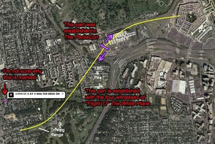
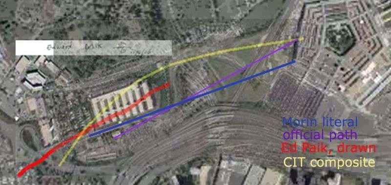
New graphic – Terry Morin’s account read literally (ie, wrong), the official path borne out by much evidence, Paik’s drawn path across the annex, and the CIT composite path merged from their four main witnesses. Note the different elements each got right or wrong; north-south location and compass heading. It’s my firm belief that Paik and Morin saw the same thing but just decribed it differently enough to create two out-runners near the official path, and that CIT took the northernmost of these two and morphed it yet further north to fuse with thir three main witnesses, below.
---
2) Robert Turcios was at work at the Citgo station when he saw a large, twin-engine, wide-winged “gray” plane. He later clarified it was more silver, with no markings he remembered, which is roughly consistent with American Airlines’ nearly-paintless paint job. He was 100% certain it flew on the north, though he saw no light poles hit in the perhaps one second the plane was visible. Shortly before the building, he saw the plane pull up over a 20-foot-high over-road traffic sign - and thence, one would think, over the building. Turcios seemed confused and a bit annoyed when Ranke asked about a flyover and/or second plane; as Marquis’ voice-over explained, the witness still believes the silver jet hit the building, even though his account makes it “impossible." The subtle implication seems that Turcios is an idiot, but if pressed, the CIT folks would probably say he just had to believe it hit but that this bias does not adequately mar his testimony.
Note: Turcios' testimony had him at the station's south end, and running up the little mound to see the plane pull up. This is not shown in the proper view of the Citgo security video, which CIT strenuously denounce as irrelevant evidece regarding their Citgo-centered case. It was an anti-Turcios smear, they insist, first released just ten days after they first announced on September 5 2006 that they had a north path witness. As Craig explains, the video release was “done to discredit Robert Turcios since he is not visible in the video.” Another possibility is the video is real and their witness was simply not there to do what he says he did and his testimony is bogus. And again, besides Robert not being represented, there is a large shadow inserted consistent with a plane to the south of his (reported) position, when he had indicated it was just north. Proven manipulated? They had better hope so.
Some observations on Turcios’ account: was he even outside the station?
A unique intuitive reaction to the Turcios interview by StevenWarRan (apparently no longer up) noted the subject “gets upset in direct proportion to the pressure placed on him to say a certain thing in a certain way, I saw a common attribute hidden by its obviousness: the quick ins and outs, sometimes only a few words long, without any continuity, like computer viruses battling.”
John Farmer flash presentation: I’m not sure this is really Turcios here but it’s interesting nonetheless.
---
3) Sgt. Chadwick Brooks was a Pentagon police officer on patrol at shortly after 9:00 am, when he pulled into a parking lot next to the Citgo to catch news on the New York attack. After he'd been there a while, the plane suddenly came in from the west, to the north of the station. He saw impact and fireball, presuming that the plane impacted building, but saw no light poles hit. He thought it was a 737, and emphasized to Ranke the plane’s size and large number of people on board. He saw no second plane.

The oddest part of Sgt. Brooks’ account is his recollection of the plane’s color, described as off-white or “champagne.” He thought markings were of a United Airlines plane, with blue letters, but UA planes have distinctive dark blue and mid-tone gray color schemes. And no one else has described a United plane, the official one of course being a red, white, and silver AA plane. Is he inserting the color scheme to fit with the airliner he thought (from news reports) had hit the building? Ranke doesn’t probe the sergeant on this, and the narrator fails to point out or explain anything as far as inconsistencies, instead moving on swiftly to their obviously favorite witness...

---
Note:
The silver-white problem has been worked out – CIT has decided the plane is now white, the flyover white jet that apparently came down the river and looped in from the southeast and then north of the Citgo. Apparently anyone who said silver meant white, and anyone who said white (or near white) meant white, not silver. Lettering and design color issues are probably addressed somewhere too. I'm behind on the specifics here.
---

Sgt. Lagasse and Brooks at the Citgo. Brooks has just drawn his flight path for Ranke.

4) Sgt. William Lagasse, a pentagon police dog handler, provided a rather solid presence to the northerly flight claims, having been already famous (in some circles) for his earlier testimony of the attack; the son of an aviation instructor, and familiar with all major plane types, he instantly identified the culprit undeniably a a silver AA jet, probably a 757. He had his dog in the car, which he was filling up at the Citgo station after chatting with some cops about the NY attacks, when he saw the blur perhaps 100 feet up and then heard it swooping down, in less than a second exploding against the building. No flaps or landing gear were down, and he could see shades pulled down on the windows as it came in from the north. He was pretty sure it actually hit with a “yawing” motion, having observed no pull-up. He saw no light poles seeing hit, but there were ones down so he presumed they were cut by this plane. He’s 100% “bet my life on it” certain that the plane flew over his left shoulder into the building, placing it to the north. Ranke did risk upsetting his interviewee by presenting him with a picture showing the clipped light poles, but Lagasse refused to believe it. Indicating the official flight path, he insisted "nothing happened over here. Period."

---
Note:
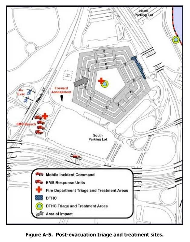
Lagasse is not suffering from vague memory, but specifically wrong memory. He specifically pointed out on a map where at least two poles were knocked down on his path that did not happen. Indicating the area he would have had to drive right through to get there, he said "none of these light poles over here were knocked down. They were here. NONE of these were knocked down." He also indicated Lloyd’s cab in that area, hundreds of feet from where it really was. CIT chalks this up to denial-driven memory alteration. Anyway, when Craig says the 'official story' put the pole damage further south, Lagasse responded - incredulously - “what official story? The only official story would’ve been the Arlington County Police Report done after the event. There’s no official story other than that. That’s the After-Action Report that was written by Arlington County.”

Just from this, it seems Lagasse feels it supports his north-side recollection. If he hadn’t studied it closely before speaking, he should have, because then he’d know how deep the ‘cover-up’ went. The text is rather vague on trajectory, but in several graphics throughout it indicated the official path (arrow at impact point) and clearly lines up with what Craig termed the official story. (note location of "forward assessment") The downed poles are on this path. Did Lagasse never see this and have his memory jogged? ‘At the cloverleaf? Oh yeah, that IS where the cab was…’
---

Lagasse also initially took them to the wrong spot, but then recalled on-camera his backing out from a different pump than he thought he was at, which Ranke notes with relief, as his testimony then matched his patrol car pulling out as captured on the Citgo’s security cameras. Lagasse had earlier cited that he was seeing the plane from the right side, meaning it was to his left, or north. This account at least is consistent with earlier, known testimony, but he clearly does not buy the no-757 theories, having repeatedly attacked the previous flyover theories of Dick Eastman. He can't be happy that his testimony is now being used to bolster - and quite well - another flyover theory. Or perhaps he's just doing his job as a link in the Pentacon disinfo web, having earlier earned anti-CT credentials in his spats with Eastman.
---
Note:
This fascinating 2003 analysis by Jean Pierre Desmoulins helps shed some light on the Eastman/Lagasse back story. This discussion has flared up time and again (like here). Craig has informed me, based on his assessment of possible motives, any such conspiracy theorizing is loopy, unsubstantiated, and so nuts he was being responsible in never bothering to consider it. Regarding this possibility of organized, malicious error in the accounts, I recently asked Craig “why have you have (so far as I’ve seen) never addressed this possibility at all until forced to? If you have ever publicly aired doubts about the main content of their accounts, or the possibility of systematic deception, now’s the time to link to it. Otherwise, embracing one ridiculous possibility as a ‘smoking gun’ while rejecting another without even bothering to explain why, to dismiss it as if it never existed, is a rather suspicious way to carry out an investigation.” He responded “The notion is so completely absurd that my answer is an emphatic NO. Nobody who went through what I went through would consider such a ridiculous assertion.” Is this an admission that he’s simply too deeply invested to turn back now? If so, he and Aldo had to both just not consider it at the beginning either, at least long enough to get this far ahead.
---
In concluding and synthesizing the accounts, Marquis explains some of the reasons the witnesses think the plane hit the building; they had been conditioned by news from NY to expect a plane to hit a building. This helped mask the plane’s flyover, and on the other side of the synchronous blast the plane simply blended in with normal air traffic, just nine minutes after all commercial flights were ordered to land, and slipped away in the rapidly thinning crowd to its own secret touchdown.
---
Note:
As of writing, no other-side witnesses witnesses testifying a flyover have yet surfaced. One attempt at finding one is “Barbara,” whom Woody Box presented as "a witness detected by ME to counter [the] claim that the flyover was observed by NOBODY." On 395 near the Potomac, Barbara saw "on the left-hand side, there was a commercial plane coming in, and […] we saw […] it go down below the side of the road, and we just saw the fire that came up after that. […] I'm not sure exactly where the Pentagon, where it was in relationship to where the plane went down but they are relatively close to one another. ... whether it hit any part of that pentagon, I'm not sure." Going down and crashing doesn't sound like a flyover to me, but WB thinks it happened just on the other side, perhaps in the Pentagon's lagoon. Even considering this confusing and misread account, there is no direct evidence for a flyover anywhere, just the partial implications of the collected witness accounts CIT keep getting.
---
The video also cites report of a second plane just seconds behind the explosion, which then veered off. These reports could've been those who saw through the con and witnessed the explosive "impact" and the plane flying off, but their presumption of two planes, in the official story, was then quickly “turned into” the attack plane and the C-130 ordered to scope the scene. But the C-130 was not seen until at least a minute later, so the “second plane” people saw was the flyover jet fleeing the scene. As for the identity of the flyover fool-people plane, the CIT’s investigation had decided on a hybrid plane with some AA features as the most likely possibility, perhaps a re-painted E4B airborne command center plane, since another one of these painted pure white was also seen in the area.
---
Note:
They do not claim an E-4B, as I cited below, since no witnesses describe a 4-engie plane. However they do still claim the C-130 was sent in to confuse people who witnessed the flyover – it appears over the immediate area by radar and video about 2 min post-impact and way up there. Little confusion possible unless reports with things like 'moments later" are read too literally the wrong way. While the newly-released radar returns of the area matches an amteur video for C-130 path and time, but contradicts with recent testimony of the C-130 pilot given to Rob Balsamo and verified with CIT via e-mail. With this flightpath untaken in the CIT construct, its rough contours have been attributed to the charter boat captain's sighting of the white jet that then circled north and presumably flew over. I'm still hazy on this point, but something clearly isn't adding up. [graphic forthcoming]
---
So besides the flyover AA-painted E4B and the later C-130 scoping out the area, there would have to be another explanation for both the light poles and the building damage. I had initially seen this as their weak point and wondered how they would handle it, but was rather surprised at the inadequacy of their explanation. On-site bombs were used to fake the airliner impact and the 300-foot-deep penetration into the building, the space that would later be filled with planted bodies, plane parts, and the very FDR that would “prove” the plane never hit the building. The tops of the light poles, marquis explains, were torn off at some earlier time and simply planted near their mangled bases, perhaps the night before, except the one that allegedly hit the taxi's windshield, but the hood was not dented also so clearly the ploe didn't fall on the car. I guess he jumped out and smashed the windshield himself just as the feds dopped the pole next to the car.
---
Note:
This whole issue is very complex and my understanding of the taxi-pole issue is still only partial, but it seems to me driver Lloyd’s account does not add up. I’m far less certain than CIT as to what this means, however, and the rest of their physical case – especially at and within the building – is at least as elaborate and silly as I had suspected (see CIT Masterlist for my partial compilation of claims and debunkings)
---
This theory leaves many questions unanswered; they admit they don’t know what happened to the passengers, for example. But these are not not enough to keep Marquis from summing up confidently “this is enough evidence to cast doubt on all of the circumstances surrounding 9/11.” The northern flight and planted poles made it undeniably clear that the attack was planned from within, and clearly radical changes will be required due to this “smoking gun” evidence. At least until someone proves them wrong. Their own eyewitnesses almost do this for them:

---
Note:
This graphic missed the reported turn that merged Paik’s path to the others, leading Craig to call it “the most deceptive idiotic confusing piece of crap ever.” CIT’s final synthesis, unless they’ve updated it, is this:

---
This vid is clearly more fraudsterism at heart, as evidenced by the thanks list at the end of the video, a veritable who's who of no-757 activists: Dylan Avery, Dick Eastman (surprise?), April Gallop, etc. Kat Turner, an actress who starred in Inland Empire (directed by Pentalawn-awed Loose Change fan David Lynch), was thanked for providing voice-overs for the PentaCon's research edition.
---
Note:
Avery had a falling out with CIT later on and is now ‘agnositc’ on what happened at the Pentagon.
---
Nonetheless, its evidence, along with the recently-released Flight 77 FDR evidence might have forced me to rethink the Pentagon attack and start allowing for a second plane. But even that isn’t the case made here - their theory is much simpler and dumber than even that. By denying the actual attack plane altogether in another frivolous overflight theory that treats the actual attack and its victims (both on the plane that hit and in the building that was hit) as secondary factors to explain away, they blew any chance of convincing me of this new flight path.
---
Note:
I still stand by that assessment, though how I worded it was manipulative sounding. I mentioned the dead - once! Un-provable black ops and ‘total control of the scene’ is explanation for any physical evidence that contradicts their theory, perpetrator control their explanation for other data that effectively conflicts. On the other hand, simple error is their reason for the bits of ‘fakery’ done wrong enough (like no foundation damage, the generator gouge, the poles laying the wrong way, fooling the north path witnesses into seeing an impact but not the right flight path) that they try to prove the impact impossible with it.
---
Curiously, the CIT don't even call on the new Black Box animation evidence despite its government pedigree and partial validation of the witness report, other than a brief nod to the PBB video by their "brother organization, Pilots for 9/11 Truth." This is one more clue that something is wrong with that aspect of the new fraud flight path, an analysis of which I'm well-into and will be posting more on soon.
---
Note:
'North path data' is illusion only: the FDR recorded the 'official path,' all but a few seconds of it. The NTSB animation seeming to show a course remarkably similar to what the witnesses described has been shown by me to be a rotation of the fial map, adding 20 degrees of heading and north of the Citgo apparently on accident. Luckily Craig disavows the FDR as governmnt-controlled data, but fiercely supports the anomolograhy of it done by his Pilots for Truth cohorts.
---

Saturday, September 15, 2007

REBUTTAL TO JAMES FETZER

LITMUS TEST FOR RATIONAILTY?
REBUTTAL TO JAMES FETZER
Adam Larson / Caustic Logic
The Frustrating Fraud
June 27 2007
last updated September 15 2007


A new press release boosting Pilots for 9/11 Truth as “driv[ing] another nail into a coffin of lies told the American people by The 9/11 Commission” was just released by Scholars for 9/11 Truth (the Fetzer wing). Co-founder of the recently-divided organization James Fetzer in fact seems to have written up the release, titled “New study from Pilots for 9/11 Truth: No Boeing 757 hit the Pentagon.” It was released on June 21 and picked up by Yahoo news, apparently a bit of an achievement, and has been widely republished since then. It demands a firm, well thought out response from my end, and hence the slight delay in publishing this (and the later edits and updates).

As the public decree explains, the Pilots had petitioned the National Transportation Safety Board (NTSB) under the Freedom of Information Act to receive data from the Black Box (FDR) of Flight 77. Their study of the data, Fetzer announced, “has confirmed the previous findings of Scholars for 9/11 Truth that no Boeing 757 hit the Pentagon on 9/11.” [1] I'm not sure "report" is quite the right word; it's "signed by fifteen professional pilots," so it seems to be their three-month-old March 26 Press Release, which summarized all their AA77 FDR findings. Fetzer sums their points: “the plane was too high to hit lamp posts and would have flown over the Pentagon, not impacted with its ground floor.” So it's not terribly “new,” and what’s even older is the tired list of hollow no-planer reasoning that is his group’s bolstered previous argument.

"We have had four lines of proof that no Boeing 757 hit the building,” he explained, all flawed, well-explained or seriously questioned elsewhere, and too boring to bother re-hashing in detail here; but briefly, 1) the too small hole and “the wrong […] kind and quantity of debris,” 2) the CCTV video that shows something smaller than a 757 he thinks, 3) ground effect, and 4) the unmarked lawn. These four tracks of reasoning prove to Fetzer, “conclusively, in my judgment - that no Boeing 757 hit the building.” Noting the eyewitness accounts of an AA 757 that flew by that way as the “most important evidence to the contrary,” he found that “if the NTSB data is correct, then the Pilot's study shows that a large aircraft headed toward the building but did not impact with it. It swerved off and flew above the Pentagon." [2] Just like others have been theorizing lately. How nicely it all falls together… and the Pilots don’t even have to offer a theory themselves.

Anyway… he wrote the piece with the cooperation of Rob Balsamo (John Doe X, co-founder of Pilots for 911 Truth), who explained elsewhere “Jim Fetzer and myself worked on this together.” Yet the final PR contained a major blunder… Fetzer stated that the Pilots “not only obtained the flight data but created a computer animation to demonstrate what it told them.” [3] What on Earth does that mean? I haven't seen this other animation yet, and had just been in a wrangle with Balsamo for hinting at just that possibility, contrary to their claims. Balsamo had to scramble to clarify their group “did not create the animation, which we included in "Pandora's Back Box". The NTSB provided the animation based upon its own data and spread spread sheets which can be found at our site/forums.” [4]
--
update 8/11: Recently Pilots for Truth did release an animation based on the black box data. It's pretty interesting and well done. Viewable here. Perhaps this is what Fetzer was talking about?
update 9/15: As Rob has pointed out to me, the crossed-out statement above is wrong - based on a misreading. Aplogies to have miseld with this sloppiness. They worked together on the corrections, as is obvious when I look back. In pennance, a gratis link to his unfiltered words.
--
Otherwise Fetzer carefully quotes Balasamo’s vague copy-and-paste master take on their findings: "the information in the NSTB documents does not support, and in some instances factually contradicts, the official government position that American Airlines Flight 77 struck the Pentagon on the morning of September 11, 2001." While it’s more tame than what Fetzer says, he’s not so much putting words in Balsamo’s mouth as – well, here’s another careful quote:

“Pilotsfor911truth.org does not make the claim that "No Boeing 757 hit the Pentagon". We have analyzed the Flight Data Recorder data provided by the NTSB and have shown factual analysis of that data. We do not offer theory.

While we do not make this claim in these words, the analysis we present on the basis of the NTSB's own data factually contradicts the official account that Flight 77 hit the Pentagon--if trends are continued beyond end of data records--and therefore supports the inference that American Airlines Flight 77 did not hit the building based upon that data.”
[5]

In other words, they have only discovered and relayed factual government data that supports the inference that the plane would not have hit. They didn’t say it didn’t hit. They let Fetzer say it for them.

“Don't be taken in by photos showing damage to the second floor or those taken after the upper floors collapsed, which happened 20-30 minutes later," Fetzer warned, and by which I’m not sure what he means. "In fact, debris begins to show up on the completely clean lawn in short order,” and proposed this fake plane debris “might have been dropped from a C-130 that was circling above the Pentagon or placed there by men in suits who were photographed carrying debris with them." [6] Might be…

The most famous such scrap, photographed by Mark Faram, Fetzer admits “is a piece from the fuselage of a commercial airliner, which is frequently adduced as evidence,” by, for example, James Hanson of Ohio. Fetzer explains in his PR that Hanson “has traced that debris to an American Airlines 757 that crashed in a rain forest above Cali, Columbia in 1995.” Check out what this genius Hanson uses for evidence: a six-year old liana vine still embedded in the Pentagon "fuselage" metal! You have to see it to disbelieve it, so DO NOT click that link if you want to believe Hanson. Fetzer bought it though and was impressed enough with this find to offer to republish Hanson’s study on the Scholars’ site. [7]

Fetzer in one of his frequent Fox News appearances (artsified by me)
One of the deepest ironies revealed in Fetzer’s missive is that "Fetzer [...] retired last June after 35 years of teaching courses in logic, critical thinking, and scientific reasoning.” Well, how could one argue with the logical conclusions of a renowned logic expert? I’ll try it caustically. Fact is, what this background of his shows to me is that he knows exactly what he’s doing – elevating a fraud to guiding principle of the “Truth Movement” he claims a leadership role in to arrive at the “truth.” In the end, from all this Fetzer was able to use his deep knowledge of ctical thinking and scientific deduction (as well, of course, as years learning all of their opposites – the arts of sophistry, quackery, and deception) to deduce an argument finally totally inverse to my own growing suspicions:

"The Pentagon has become a kind of litmus test for rationality in the study of 9/11. Those who persist in maintaining that a Boeing 757 hit the building are either unfamiliar with the evidence or cognitively impaired. Unless they want to mislead the American people. The evidence is beyond clear and compelling. It places this issue 'beyond a reasonable doubt'. No Boeing 757 hit the Pentagon."

I am quite familiar with the evidence, and I invite anyone to check my reasoning for soundness of judgment. That’s what this site’s about: “the hijacking of the 9/11 Truth Movement by the no-757 at the Pentagon theory." It almost feels with this salvo like Fetzer the mental “muscle hijacker” is letting us know the pilots have the cockpit; he tells us never mind the doubters, move to the back of the plane. No need to investigate for yourselves, we have it all figured out. We are returning to the airport. We just need to agree on this and move on.

But what if the Pilots intend to crash this plane? It’s happened before. That's not even a box cutter Fetzer's holding, people. It's a carbdoard prop. We can take this plane back. Let's Roll.

Sources:
[1], [2], [3], [6], [7] Fetzer, James/Scholars for 9/11 Truth. “New study from Pilots for 9/11 Truth: No Boeing 757 hit the Pentagon.” June 21 2007.
Trackback URL: http://prweb.com/pingpr.php/Q291cC1NYWduLVRoaXItQ291cC1UaGlyLVplcm8=
http://news.yahoo.com/s/prweb/20070621/bs_prweb/prweb534642_1
[4], [5] John Doe X. Official Comment/corrections. Pilots for 9/11 Truth Discussion Board. Posted Jun 23 2007, 12:36 AM. http://z9.invisionfree.com/Pilots_For_Truth/index.php?s=ec3b737719855ae19fc27c1b5a81c7b0&showtopic=7372&st=15&#entry9361808

Saturday, August 4, 2007

THE CSV FILE

THE CSV FILE
Adam Larson / Caustic Logic
The Frustrating Fraud
August 4 2007
rough draft


Released by the NTSB via FOIA request to Pilots for 9/11 Truth member Undertow in August 2006, the “csv file” is one of the more widely-cited sources of Flight 77 FDR information. It’s a huge file – offered by the Pilots for download:

The CSV file, AAL77_tabular.csv (zipped): dowload link

A text list of the parameters plotted: dowload link

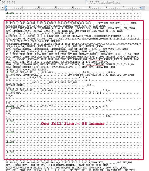
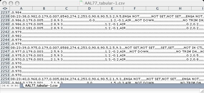
It’s a bitch to read. I had initially only been able to open the file as simple text file, with well over 300 values (I stopped counting) each represented in packed clusters for each second of the hour-and-a-half doomed flight, a total of nearly 4,700 frames. A single frame looks like this (highlighted in red is the data for the first frame at 8:19:00 am - the last frame is 9:37:44, ending as the animation does one second early):


Opening it in Excel, once I figured that out, helped little, as it doesn’t really organize the data into readable columns.


Each comma separates one of the myriad values from the next (hence the file type CSV, or “comma separated value”). Many many of them, where there are commas in a row, are blank or inoperative; the NTSB’s SFRI noted that even though “the recorder operated normally,” that report, and the CSV as well, included “only validated parameters.” The blank values, including the radio altimeter, “either were not recorded properly or were not confirmed to have been recorded properly.”

Most remain readable, but with so many values presented this way, the only way I can find anything is to have a good guess of the value I’m looking for (29.92, latitude, etc.) and do a search ‘till I find it. Out of this mess and my relative ignorance (and sporadic, stumbling tenacity), I’ve been able to verify a few oddities proposed by Undertow and his cohorts at P49T: the pressure altitude reset said to place the plane too high for impact, and the 20-mile longitudinal offset, which seems odd but irrelevant.
- I had misread the initial pressure altitude recorded and concluded the csv and animation altitudes in fact matched at the beginning, which they don't. Initial altitude reading: 40 ft msl, 250 feet underground at Dulles, 260 below the animation readout. A mess of a post... and a graph
- The numbers in the tabular csv file match the official story's flight path in latitude/longitude plots (once corrected) and timeline. Nothing new but another verification and a nifty new graphic.
- There seems to be a slight north offset as well, depending on if I'm reading this right. At any rate, the graphing of the csv final plots that helped me see this is interesting for its own reasons.

20 MINUTES AND 20 MILES FROM TRUE

20 MINUTES AND 20 MILES FROM TRUE
CSV LONGITUDE READINGS
Adam Larson / Caustic Logic
The Frustrating Fraud
August 4 2007


A recent anonymous comment left under my post Pentagon NTSB Animation is Wrong! said:

“Funny stuff watching a bunch of half witted pilots and so called experts run around making up ideas on something they do not understand but have been told about. Take a look at the FDR data please. Now tell me where is Flight 77 at takeoff, and at the last data point. Come on experts like Snowy, tell me where Flight 77 is. Any point in time will do. Bet you can not place it better than 1000 to 3000 feet. Too bad we did not have GPS to knock that down to 100 to 300 feet. Sad thing is, after reading the posts around the internet, the FDR was found in the Pentagon as were all the bodies from77. The people who make up stuff about Flight 77 are sick people.” [1]

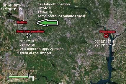
I remembered some comments from the “experts” at Pilots for 9/11 Truth about positional problems in this data, so I took the challenge and found – ironically enough – the debunker had pointed to an interesting anomaly that it seems places the plane’s final resting place twenty miles west of the Pentagon. I duly note the irony that this gives me something to agree with the Pilots over, as core member Undertow had just alerted me of “the CSV Lat/Lon data screw up,” wherein “it is off by 20 Minutes.” [2]

It’s somewhat daunting to look into the CSV file, but this time it only took a few minutes to ascertain the final recorded position: N38°52',W077°25'. There are no seconds reading to pinpoint (60 seconds make a minute, 60 minutes a degree), but it appears about right for north placement, but far off for the longitudinal (east-west) placement. It should read 77°3’30” Indeed, it’s off by 21.5 minutes, in this case a discrepancy of roughly 20 miles, or directly over Chantilly.

Where does this discrepancy enter the picture? I feared it would take a while to track it back, but again, no problem. Location at takeoff (from frame 08:21:27: N38°56',W077°53' The map I looked at places the end of the runway at 38° 56' 40" N, 77° 30' 11" W. Again the same northern position, but 23 minutes to the west. The discrepancy is there the whole time. The slight difference is probably due to the lack of seconds data that would tell just where in each zone it was for sure, introducing a small fudge factor of inevitable imprecision.
Pilots ally John Farmer has analyzed the data closely and found it "unreliable," and now I see clearly what means when he says the csv file "has the plane taking off from a field west of Dulles and crashing somewhere well west of the Pentagon (look at the coordinates stupid).” [3] In fact, as seen in the map above, its data ended just south of Dulles where it was supposed to have begun. The data set gets curiouser and curiouser. But why? And to what net effect?

The difference runs across the board and so is almost as easy to correct as the animation's four-hour-ahead time stamp. Simply add about 21-23 minutes to the west readings. That and realize there’s no real precision possible with the csv’s numbers other than that it took off just as Flight 77 departed Dulles, and ended just about 20 miles east of this origin just at nearly the second that Flight 77 is said to have hit the Pentagon 20 miles east of it's origin. I can’t say for sure but this FDR anomaly seems massive, inexplicable, and totally irrelevant.

Sources:
[1] http://frustratingfraud.blogspot.com/2007/05/ntsb-animation-is-flat-wrong.html - comment left 7/27/07, 7:56 pm
[2] Undertow. Posted July 26 2007, 9:36 am. Above Top Secret.com -> 9/11 Conspiracies -> "Pentagon NTSB animation – three Cds."
http://www.abovetopsecret.com/forum/thread291782/pg1#pid3383439
[3] Farmer, John. "There is Always a Skeptic." 911files.info. June 5 2007. http://911files.info/blog/?p=230

Monday, July 16, 2007

A SLOW ZOOM ON THE FINAL LOOP

A SLOW ZOOM ON THE FINAL LOOP
Adam Larson / Caustic Logic
The Frustrating Fraud
July 16 2007
last updated July 19


Connecting the Dots
The initial flight path of hijacked Flight 77, as published in the days after the attacks, was largely a connect-the-dots approach. With no transponder after the terrorist takeover, and, we were told, “limited primary radar coverage” along the attack route, the return flight was not seen for a half-hour until it entered Washington airspace with its own radar. [1] The dotted line estimations published at this point sowed among the first seeds of suspicion over the attack. Was there a swap out there in the blind spot? As more evidence comes to light, all these paths have proven broadly accurate in that the 757 headed west, turned south over the WV-KY-OH border area, lost transponder, and returned, heading East straight to the Pentagon. Of the three maps above, Newsweek’s is the most accurate. USA Today’s path has a pronounced hump giving it a submarine profile, and Time’s map has the plane swooping north on its way back, crossing its outbound flight path, twisting the loop into an infinity symbol.

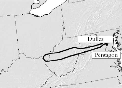
The final line of the journey as it passed east of its origin at Dulles, seems from here uneventful. But in these same early days reports surfaced of a tight, controlled, implausible loop over eastern Virginia, thought by many beyond the reported skills of the alleged hijacker Hani Hanjour. Facing the west wall, Flight 77 was said to have turned 270°-360° to hit - the west wall – oddly enough, the side just renovated to withstand bombs and impacts, largely empty, and across the building from the Defense Secretary’s Office. [more on the radar blind spot and the impact location in "From the blind spot to the empty side."]

Few if any eyewitness accounts seem to address the grand loop, since it was simply too big to have been seen by any one person – the first part of it was perhaps too high to attract much attention, but as it approached the Navy Annex and continued to lose altitude, it attracted more witnesses in its last several seconds, by which time it was going straight towards the Pentagon’s west wall. With such published accounts as the early cornerstone of our awareness of the attack, this magical loop remained largely invisible, possibly another government lie.

The overall uncertainty over 77’s approach lead many to accept this flight path as plausible to explain the final loop. It has Flight 77 flying south through DC’s restricted airspace with no White House defensive fire, headed towards Rumsfeld’s office before turning to hit the opposite side of the Pentagon, giving us the 270° turn so often cited. This map is quite wrong, understating the actual degree of turn by 60° and grossly misreading the original heading. [How this old map was arrived at and what’s wrong with it is explained separately in "the "old" 270° loop explained."]

The Radar Record
Among the too-vague early report was this from the ever-unbelievable Vice President Cheney, five days after the attack: "it entered the danger zone and looked like it was headed for the White House [...] Didn't circle it, but was headed on a track into it. [...] It turned away and, we think, flew a circle and came back in and then hit the Pentagon. And that's what the radar track looks like." [2] Five days later CBS News reported “radar shows Flight 77 did a downward spiral, turning almost a complete circle,” after which “the jetliner disappeared from radar at 9:37 and less than a minute later it clipped the tops of street lights and plowed into the Pentagon at 460 mph.” [3]

It was another month before radar specialist Danielle O’Brien, on duty at the Dulles ATC tower on 9/11, told ABC News’ 20/20 “it was an unidentified plane to the southwest of Dulles, moving at a very high rate of speed [...] I had literally a blip and nothing more.” As it headed towards the Pentagon, “it was just a countdown. Ten miles west. Nine miles west […] And it went six, five, four. And I had it in my mouth to say, three, and all of a sudden the plane turned away. In the room, it was almost a sense of relief.” But the turn continued until it was much lower and facing the same direction, after which O’Brien tersely summed up "we lost radar contact with that aircraft [...] and then the Washington National controllers came over our speakers [saying] The Pentagon's been hit.” [4]

O’Brien’s interview, aired in late October 2001, was accompanied by a radar screen graphic with a south loop of near 360 degrees off the east-bound flight as seen on radar screens. Seen briefly by millions, perhaps many thought this arc of dots just a guess or irrelevant, but in fact this same path would prove accurate and come back to bite them in the butt five years later. [Other than the red lettering, this picture is a direct screenshot from the program, viewable here.]

Official Reports: Zooming the Lump
We were only allowed a slow zoom in on what that loop actually looked like in the chain of official reports. Initial NTSB studies were kept behind closed doors, being in the FBI’s jusrisdiction and exempt from FOIA requirements. But the correct loop is there in a map from the 9/11 Commission’s Final Report, released mid-2004. Note its general agreement with early reports, and also the little lump of ink on the south side of the terminal tip – that’s the final loop, unreadable in this bold line on an unnecessarily zoomed back map. This line is apparently taken from the NTSB’s Flight Path Study, made from FDR and radar data in February 2002, classified at the time but available to the commission and cited in the endnotes. The report explained how at "5 miles west-southwest of the Pentagon," Flight 77 "began a 330 degree turn." [5]

That document was finally released via numerous FOIA requests in August 2006 and posted online from numerous angles. Finally we see a zoom in on the mysterious grand loop [see below]. First we see their overall flight path, printed big enough to show a silly little loop at the end [blue box], and also a detail of the loop all on its own page, faded yellow on a pale orange topo map [red box]. This is labeled in the report as “DC area flight path,” so possibly from ATC radar track, while the overall flight path above it is said to be from the matching FDR/radar data. [6]

The Black Box
Additional Flight Data Recorder information further verifies this loop. The Specilaist’s Factual Report of Investigation (SFRI), is an NTSB documented drawing exclusively on the full Black Box readings, also released in the 2006 rush. It has all functioning parameters graphed out for the duration of the flight, spread out over 17 pages; The basics -altitude, airspeed, and magnetic heading - are reproduced on each page. Here is the clearest extraction I've taken of this, edited to show a zoomed-in final minutes reading. All lines and values are accurate according to the bars at right and left. [7]
The story it tells is that at 9:34 Flight 77 began a remarkable thhree-minute turn just short of the Pentagon. The change in magnetic heading is graphed - as it approached DC with a general heading of about 95-100° magnetic –after a slight adjustment to the north and back at 9:31-32, the plane begins its loop at 9:34 – for about three minutes it turns south and then near-full circle to the west, north, and finally settling, at about 9:37, on a northeast heading of 70° magnetic, after completing the 330° turn and descending about 4,000 feet in the process, the last 45 seconds were a straight shot at that heading and a steady descent to roughly zero altitude at 9:37:45.

Here is how to read the headings on a map - apologies for the fruit-flavored style if that offends anyone’s sensibilities. The angle and color tells headingat a given mement, tehe direction the nose is pointing. Magnetic heading, which the FDR works with, are just about 10° higher compared to headings based on geographic north, since the magnetic north pole at that time was about ten degrees west of the true north. Read zero also as 360, due north, green. Here the plane starts out deep blue – due east, roughly 90° from north, 100 mag on the FDR - and its final heading is about 60°. Add ten to get magnetic, and this is what the FDR says – 70°.

The erred NTSB working copy animation, used by Pilots for 9/11 Truth, matches as well the official loop; their “final maneuver” video starts out at 9:34:03, turn just starting, and straightening out from 9:36:45-9:37:15 The onscreen mag heading dial roughly matches the other FDR data, settling on 70 after the loop – but of course the on-screen animation somehow ends up twenty degrees off from that, which is what places it “too far to the left” to have impacted the Pentagon, as the Pilots discovered…

Sources and editing: Coming
[1] Phillips, Don. “Pentagon Crash Highlights a Radar Gap.” Washington Post. November 3, 2001. Page A06. http://www.washingtonpost.com/ac2/wp-dyn?pagename=article&contentId=A32597-2001Nov2¬Found=true
[2] "The Vice President appears on Meet the Press with Tim Russert." Camp David, Maryland. September 16 2001. http://www.whitehouse.gov/vicepresident/news-speeches/speeches/vp20010916.html
[3] "Primary Target - THE PENTAGON." CBS News. September 21 2001. http://www.cbsnews.com/stories/2001/09/11/national/main310721.shtml
[4] "`Get These Planes on the Ground' - Air Traffic Controllers Recall Sept. 11," ABC News, October 24 2001. http://web.archive.org/web/20011024150915/http://abcnews.go.com/sections/2020/2020/2020_011024_atc_feature.html
[5] National Commission on Terrorist Attacks Upon the United States. The 9/11 Commission Report. map: p. 33. Citation of Flight Path Study: Page 459, source 59 for chapter 1. Explanation of the loop on page 9.
[6] FPS
[7] Specialist’s Factual Report of Investigation: Digital Flight Data Recorder . NTSB document number: DCA01MA064 National Transportation Safety Board, Vehicle Records Division. January 31 2002. PDF download link: http://www.ntsb.gov/info/AAL77_fdr.pdf