WHERE DID THAT COME FROM?
Adam Larson / Caustic Logic
The Frustrating Fraud
Posted July 25 2007
last updated 12/9/07
Note: This article deals with Steve Koeppel's loop map only. Arabesque has also posted an excellent post partly on this article, related with the three planes-confusion (FL77, a C-130, and an E-4B "doomsday plane," all verified in the area at the time), later expanded to cover other areas.
Note 12/9: Steve Koeppel himself (I presume) has popped in here to help explain some things (see comments below). "I did state that I had been an Air Force and Reserve navigator (I am NOT pilot in the military! Would somebody clear that up?!?)" Yes. Koeppel was not an Air Force Pilot as cited by The Power Hour. He was an Air Force navigator. "AT THAT TIME (early 2002) my intent was get suggestions on why there weren't any tourist photos (of Flight 77) [...] I made no claim to creating the unimpeachable analysis," he clarifies, "nor was that my intent; that's why I put so many qualifiers in my post." Good. Among the scant evidence he called on to create his path, one escaped my detectors and still does: "after disappearing from the radar scope the aircraft had had reappeared approaching D.C. from the north and was thought to have been aiming at the White House..." See below for full comment.
---
For years after 9/11, as controversy swirled over the details of the Pentagon attack, a working draft of the highly suspicious reported 3/4-circle loop in the flight path became widely used to cast doubt on the official story. This grand loop over Washington became one of the unifying points of agreement between Hunt The Boeing Pentagon no-planers and remote control-757 advocating “plane-huggers.” The general gist was eloquently summed up by Nila Sagadevan in early 2006:
“[T]his fanatic Muslim kamikaze pilot […] found that his “missile” was heading towards one of the most densely populated wings of the Pentagon—and one occupied by top military brass, including the Secretary of Defense, Rumsfeld. Presumably in order to save these men’s lives, he then executes a sweeping 270-degree turn and approaches the building from the opposite direction and aligns himself with the only wing of the Pentagon that was virtually uninhabited due to extensive renovations that were underway” [1]
While this sounds compelling, the flight path he’s talking about never existed. It was bolstered and seeded in the movement, above all, by this map:
 Those who cite this precise angle of turn, point out the lack of White House defensive fire as the plane passed within a mile or two of it, or of the plane going out of its way to avoid Rumsfeld’s office, for which it was headed, are probably referring to this map, if to anything specific. Russell Pickering’s Pentagon Research.com used it to illustrate; “you can see where the White House was passed.” He also carefully cited the map’s originator, which makes it easy enough to look up and double-check. Author: Former Air Force Pilot Steve Koeppel, Palm Springs, CA [2]
This led me to Koeppel’s undated piece, from way back, some time in 2002 it seems (it was mentioned by Hufschmid in Painful Questions, released 2002). The map and explanation of it were hosted originally by The Power Hour, producers of 911 In Plane Site, which is among the worst 9/11 videos ever, often dismissed as a too-long joke on the Truth Movement. Whatever the merits of his hosts, Koeppel's piece there explained how he reasoned out the map; none too promising is how he starts out with (apparent) inexplicable ignorance over the general contours of the flight:
“It was fairly simple to find the WTC routes, but I have yet to see a map showing the route flown by the aircraft that was said to have hit the Pentagon. So I read some of the reports and put together the attached maps. […] I'm surprised that I haven't seen this map — or ANY map — of the Pentagon airplane's approach. Given all the information that we were deluged with in the weeks after the attacks, it surprises me that this graphic was omitted.” [3]
The flight path of Flight 77 was not omitted by any measure, and it was not hard to find – even I knew the general outline of the flight, as : first published in Time, Newsweek, etc in the days after the attacks. Yes, the return path was a dotted line back then, estimated obviously, and too vague yet to show 77’s final loop, which was apparently his main question. But all these paths have proven broadly accurate in that the 757 headed west, turned south over the WV-KY-OH border area, lost transponder, and returned, heading east straight to the Pentagon. “Guardian” was one of the few that noted of Koeppel’s path “that this is a very strange flight path for an aircraft coming from the east and planning to crash into the Pentagon.” [4] It’s at least as odd for Flight 77, which was coming in from the southwest and finally impacted from the southwest, to wind up swooping down on the Pentagon from the northeast as in Koeppel’s map.
As an ill-fated aside before explaining his sources, Koeppel pointed out “what's surprising is how many news sources got the information wrong. For example, look at this graphic from Reuters, which has the attack on the wrong side of the Pentagon:”
 Above is the graphic he used [right-click, new wiindow to enlarge], labeled “The Pentagon Attack” and featuring a six-point timeline of events, along with a grossly incorrect impact point shown. What’s at least as surprising, in my opinion, is where Koeppel explains “I based my map of the attack path on a description of the attack (see Pentagon Attack) which said the plane was initially picked up on radar east-southeast of Dulles heading at high speed toward Washington.” [5] Red flag! He introduces the erred Reuters graphic, and then tells us his whole analysis is based on a single account, and it’s this same graphic.
 Another wrong point in it he (understandably) failed to catch was its understatement of the loop by 60° – it was indeed to the right (south) but was actually 330°, nearly full circle, a descriptor widely used outside of the source he chose. As for how he came up with the southward swoop, Koeppel explained it as starting from “the 270 degree right turn” leaving him “puzzled.” A “near-circular” turn to the right, off an approach from the west, to hit the Pentagon at the final angle he gave no clue of being aware of, Koeppel might’ve guessed something like the official and logical connecting loop (here in yellow). Instead, he decided to bring it in from the north; “I realized that [the 3/4 loop] would provide a simple set of landmarks for the pilot. Just intercept the Potomac River north of town, follow it south until you see the Washington Monument or Capitol,” and then, as the Reuters guy said, make a 270 degree right turn and hit the far north edge of the west wall at the fourth-floor level. So thinking like a novice pilot, he found an arbitrary 270° line of landmarks in that area that might guide one to the target, and then presumed that to be the most logical flight path that he felt “meets all the conditions in the description.” Below is a map that helps clarify that his entire red arc is indeed east-southeast of Dulles, barely, and this seems to be a plausible path – if we disregard the official and logical flight path up till then (blue).
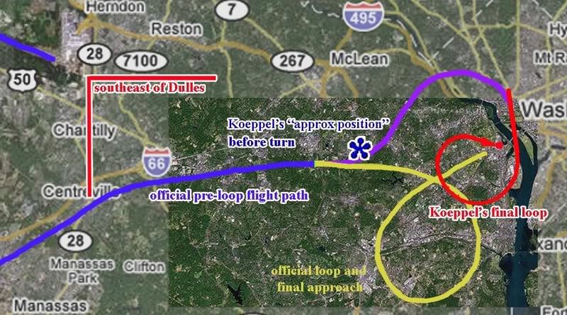 If the final loop Koeppel arrived at (red) was to be connected with the official story path (blue), that would necessitate the purple arc, or something similar, to connect the two. Since he was generally aware of the plane's position before turning (blue asterisk in the center of my map, actually pretty close to the official flight path, and nowhere near "the Potomac river north of town"), he in fact was implying the purple arc. However, he fails to explain or illustrate this turn to the left/north around and over DC, which is nowhere in his Reuter’s graphic or any other account. He made no mention of the full implied loop of roughly 400° from there needed for his loop to work.
 In short, despite his ignorance of “ANY map of the Pentagon airplane's approach,” Koeppel was able to place the plane properly before its turn, but then invented the wild purple and red maneuver and only explained and illustrated the second half of it. He called this analysis and map “my contribution to the effort to try to make sense of an insane event. I don't know if it adds clarity or static, but it seems a part of the puzzle that has been missing.” [6] Looking at the method that gave us that half-map, it was clearly static he added. What’s surprising is that no one apparently caught on and this map became almost gospel. It was so widely used and believed to explain the oddity of the Pentagon attack (which is still odd enough) that it was interpreted by “Guardian” as possibly official; “the claimed flight path of flight 77 over Washington. […] In reality, flight 77 never existed.” [7]
The real loop, 330° to the south off an easterly approach, was new to some of the top 9/11 Pentagon researchers in mid-August 2006. At the Loose Change forum, Killtown showed the NTSB yellow-line loop map, seen in the just-released Flight Path Study. He labeled this as “new,” compared to Koeppel’s map, labeled “old.” Pickering, who had promoted the “old” map by featuring it on his site and working it into his other material, responded “the new flight path data does not change everything,” but it did help indicate to him that “I have a lot of re-writing to do these days!” Another member noted Pickering’s reliance on Koeppel’s map, and wondered of Koeppel “what he based his information on?” The question was not answered there, but I hope this analysis helps shed some light on the subject. [8]
---
More people who had fallen for it at some point (besides me, not that I even looked close until now): Jim Hoffman at one point used Koeppel's map to illustrate how a "Spiral Attack Maneuver Avoids Top Brass."
The bastards at Judicialinc captioned the map "NORAD's story that Hani Hanjour flew a 757 doing 600 MPH at 7000' and went into a 270 degree decending turn and hit the Pentagon, is absurd."
---
Sources:
[1] Segadevan, Nila.“The Impossibility of Flying Heavy Aircraft Without Training.” Looking Glass News. Feb 20, 2006
http://www.lookingglassnews.org/viewstory.php? storyid=5115
[2] Pickering, Russell. “Analysis of Flight 77 Flight Path” Pentagon Research.com. http://www.pentagonresearch.com/017.html
[3], [5], [6] [Koeppel, Steve. Analysis of Flight 77: Flight Path by a Former Air Force Pilot.” The Power Hour. Undated. http://www.thepowerhour.com/911_analysis/steves-analysis.htm
[4], [7] Guardian. “Flight 77 and the Pentagon. What Really Happened?” Undated. http://guardian.150m.com/pentagon/small/911-flights.htm
[8] Pickering, Russell, Terry Zarzoff, and Killtown. Comments posted August 12 2006. Loose Change Forum -> The Pentagon -> "New Flight 77 Path Different (of Course)." http://s15.invisionfree.com/Loose_Change_Forum/ar/t10366.htm


