First Posting
9/24/08, 2am
updated 9/28, 11 pm
Alright, so at the JREF, this "Turbofan" character has been making a lot of noise in Anti-Sophist's FDR thread, criticizing the "pros" there and acting as if he knows everything about Flight data recorders, and along the way hinting at the old Balsamo sticking-point, the refusal of sane people to debate him on the phone. Well, I'm only half-sane, and offered to accept his challenge on condition he send me two dozen homemade cranberry muffins. He unexpectedly took me up, and after a series of PMs where we started out actually haggling over the muffins, we decided on last night. I was at work, but took a break when he called, about 5:45pm, put the speakerphone on, and recorded my fairly down-key conversation with Tino, as he gives his true name. For those familiar with his on-screen persona, so remarkable arrogant and Balsamo-esque, his real-time discussion manner is so much more - Canadian. It's almost like two different people, and the Tino I talked with in fact knew little about FDRs, having only garnered his knowledge from talking with PfffT, and couldn't even cite the values that were so discrepant in the final frame of data. The audio turned out pretty decent, and as soon as I decide a good way to share it, and for good measure confirm his consent to do so, well, then I'll do so, and add some notes and stuff.
---
Here's the audio
Boomp3.com
Additional Notes: [apologies for being so slow. I'm fairly busy elsewhere these days]. Regarding the audio, the line noise came out worse than I though - unshielded cables, please try to ignore. I figure there's no point in arguing for a win with a sock puppet or irrational person who's simply set in their course; as Swift says, via Pomeroo, "you can't reason someone out of something he was never reasoned into." So I may come across soft, but hardness hardly seemed necessary against this underwhelming opponent, and I was speaking to the (hypothetical) reasonable person inside who's ready to stop being led astray. Other notes later.
Showing posts with label FDR. Show all posts
Showing posts with label FDR. Show all posts
Thursday, September 25, 2008

Friday, August 8, 2008
OVERWHELMING EVIDENCE FOR 9:38
PENTAGON ATTACK TIMELINE QUESTIONS PART 3: OVERWHELMING EVIDENCE FOR 9:38
Adam Larson / Caustic Logic
The Frustrating Fraud
August 7 2008
Last Updated 8/10/09
For those who see no reason to question the official time of the Pentagon attack, this post will be unnecessary. But for those confused by claims of different times, primarily 9:30-32 am, this may prove quite useful. If you're willing to learn... (sigh). Of all the times cited for the impact/explosion/whatever at the Pentagon on 9/11, one stands above as the most-cited, most-supported, and most-likely true – by this I mean, approximately, 9:38 am. Officially the explosive impact of Flight 77 is given as 9:37:45 or :46 based, it seems, on the Flight Data Recorder. In reality, the impact time is impossible to pin down exactly, but likely a bit after this, probably between 9:37:50 and :55 (see FDR section, first up). Following is a nearly-comprehensive list of the most direct evidence establishing the impact at right around that time.
1) Flight Data Recorder:
Much rhubarb has been made of the information on Flight 77’s Flight Data Recorder and how it doesn’t match the reality necessary to get it inside the Pentagon where it was said to be found. The last frame of data recorded is 9:37:44 or :45, depending on the exact file one’s looking at. While this is officially the moment of impact, the recorded values do not match those evident in the physical damage (most important – too high!) This is taken by some nitwits/liars as proof the plane didn’t hit. Another view takes this as a clue that this last data is actually NOT from the moment of impact, but a mile or more back, as the INS positioning says (it’s prone to error of about 1/2 mile I hear). Most analysts have come to this realization, though opinions differ on how far back, how much data is missing, and why (which is beyond the scope of this piece). Estimates range from 2 to 10 seconds remaining to impact at last frame, with the upper end of 8-10 seeming most likely to me, and placing impact at 9:37:50 or later. This slight variation of the “official” time alternates with it in the list below and illustrate that roughly all evidence points at a roughly 10 second time range best rounded to the minute as 9:38.
 2) Radar:
We’ve always heard the radar data supported and defined this impact time, but fact is it can’t tell us exactly when, or even if, the plane impacted. The raw data of the Air Force’s 84th radar evaluation squadron (84RADES) was released in 2006 to researcher John Farmer, showing all returns from the DC area on 9/11. As I understand it, ‘blips’ are sent and returned every 12 seconds; the last three attributed to Flight 77 are at 9:36:48, 9:37:00, and 9:37:12 (see graphic at right, from Marco Bolletino’s reconstruction of the data). Before the next return, the airliner dropped below the coverage level of app.2,000 feet above ground [this altitude is passed by FDR about 9:37:18]. There is an established NEADS clock issue, known to be app. 25 seconds slow relative to other clocks in the FDR and at ATC facilities. Therefore, the last return would actually be at about 9:37:37, with impact presumably some seconds after that. This support is vague but would hint at an impact somewhat later than the official time less than ten seconds hence. On the other hand, the FDR pressure alt for 9:37:37 is 786 ft AGL, which seems too low to be just disappearing from radar. Perhaps I’m confused on the timeline discrepancy. Anyway, it’s all there… it doesn’t prove a 9:38 impact, but it fits it just fine.
1a+2a) FDR/Radar Combo:
In its Final Report, the 9/11 Commission gives the impact time of 9:37:46 [p 96], citing as its source NTSB report, "Flight Path Study-American Airlines Flight 77," created Feb. 19, 2002 by the National Transportation Safety Board. The full document in question is available in PDF form [here. The report in turn lists its sources as FDR data “as well as” (implying no conflict with) “radar data from the Federal Aviation Administration’s Air Route Traffic Control Centers, approach control at Washington Dulles Airport, and the U.S. Air Force’s 84th Radar Evaluation Squadron.” [This is the data examined above]. From this, the report summarizes that “the airplane accelerated to approximately 460 knots (530 miles per hour) at impact with the Pentagon. The time of impact was 9:37:45 AM.” Ooh! A one-second discrepancy! And both were likely a bit early, with the Commission closer it seems.
3) Arlington County Emergency System:
From Arlington County After-Action Report, and its first-hand access to emergency communications , we can see that key information was called in just before and after the 9:38 mark, and reactions followed in the next minutes, as recorded and logged as at a time generalized as 9:38. [emph mine].
“In the moments immediately before impact at the Pentagon, the Arlington County ECC began receiving 9-1-1 calls reporting a low flying airliner that seemed off the normal flight path. When the crash actually occurred at 9:38 a.m., all area communications seemed simultaneously overwhelmed. Firefighters calling the ECC couldn’t get through. Relatives of Pentagon workers found cellular and land lines jammed. Emergency traffic flooded radio channels.” [page A-34]
“Captain Steve McCoy and the crew of Engine 101 were […] traveling north on Interstate 395 [when they saw] a commercial airliner in steep descent, banking sharply to its right before disappearing beyond the horizon. At 9:38 a.m., shortly after American Airlines Flight #77 disappeared from sight, a tremendous explosion preceded a massive plume of smoke and fire. Unable to pinpoint the precise location, Captain McCoy immediately radioed the Arlington County Emergency Communications Center (ECC), reporting an airplane crash in the vicinity of the 14th Street Bridge or in Crystal City.” [page A-34]
At 9:38 a.m., a large smoke plume appeared beyond the Rosslyn skyline. Arlington County Police Corporal Barry Foust radioed the ECC that he saw an American Airlines jet crash into the Pentagon. The ECC swung into action [page A-35] […] [B]etween 9:41 a.m. and 9:43 a.m. on September 11, the ECC Administrator, Steve Souder, acting on his own initiative, contacted the Fairfax, Alexandria, and District of Columbia fire departments. He gave them identical instructions: deploy four engines, two trucks, one rescue unit, four EMS units, and a command officer to a staging area short of the Pentagon and hold them there until called forward.” [page a25]
4) C130 pilot report via FAA:
The 9/11 Commission briefly discussed the “second plane” at the Pentagon, a C-130H cargo plane dubbed “Golfer 06.” The Commission noted on page 26 of their final report:
“At approximately 9:38 A.M., the C130H aircraft reported to Reagan Airport controllers that the aircraft it was attempting to follow crashed into the Pentagon.” The source is given as “FAA audio file, Washington Tower, Tyson/Fluky Position, 9:38:52 .-M.; FAA letterhead memorandum, 'Partial Transcript; Aircraft Accident; AAL 77; Washington, DC; September 11, 2001,’ 7.
Although the two planes had crossed path just a minute before, both radar and the pilot’s own words agree that Golfer 06 was too far away to see Flight 77 itself at impact, but was close enough to see the smoke and to know where it was coming from. Certainly the impression was there from the beginning, and was only confirmed as it approached at 9:38, passing nearest to impact point at 9:39:15, after which it veered off to the north and west and continued on to witness the crash site of Flight 93 as well before reaching base in Minnesota.
5) 9:39 News Report - NBC:
Among the most solid clues to at least the general time of the attack of the Pentagon attack is in NBC News coverage of the 9/11 events. [video link - when watching the video, note that it starts at 9:12 am, so the video time is to be added to this for the real time] At perhaps 10 seconds after the 9:39 mark [26:24 video time], the newsroom interrupted its coverage to let Pentagon correspondent Jim Miklaszewski bring them their first news of something awry there. He told the nation:
"I don’t want to alarm anybody right now, but apparently - it felt, just a few moments ago, like there was an explosion of some kind, here at the Pentagon.” He explains he was on the east side of the mammoth building, opposite from the impact, so it was a big explosion. He saw no smoke from his side, inside the E ring, and didn’t know what was going on. “I just stepped out in the hallway, security guards were herding people out," he explained, meaning some time at least had elapsed. So far impact is looking to be one minute, 15 seconds before this broadcast. Sounds like “moments” to me.
6) Security video time stamps – Pentagon, Doubletree, Citgo:
Though neither the Citgo or Doubletree videos, released in 2006, shows the official time in their on-screen clocks, both timers roughly bracket it: Doubletree – 9:34:10 impact (app 3:35 behind) Citgo 9:40:36 (app 2:51 ahead)
It’s a very small sample to be conclusive, but this is what’s called a normal distribution, that sets a center point of app. 9:37:00. That’s pretty close for a sampling of two clocks, one of which also bears the default date of Jan 1 1993 [for a clue to the professionalism and precision of their deployment].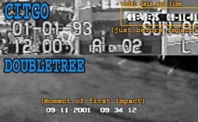
Regarding the time stamp of the Pentagon’s own CCTV gate cameras that famously captured the plane and impact, Col. Alan Scott told the 9/11 Commission in May 2003:
“The timeline on the impact of the Pentagon was changed to 9:37 -- 9:43 is the time that was reported that day, it was the time we used. And it took about two weeks to discover in the parking lot of the Pentagon this entry camera for the parking lot, which happened to be oriented towards the Pentagon at the time of impact, and the recorded time is 9:37. And that's why the timeline went from 9:43 to 9:37, because it is the best documented evidence for the impact time that we have.” [source]
It should be noted that the time stamp is not reproduced on-screen. The initial five released framed show a time of the following evening Sept 12 – much to the delight of mystery-mongers, it’s more likely the time the frames were processed and labeled “plane,” “impact,” etc… but they seem to have been recorded in the 9:37 slot on the correct day, and were in fact instrumental in setting the time initially. We find later it’s actually near the end of that minute, but still technically not 9:38.
7) Eyewitnesses:
Considering the known unreliability of eyewitness recollection, and that most people do not directly time-stamp their memories, it should not be surprising that this sector of the evidence is the least clear on the actual impact moment. Just a few of the published accounts provide useful clues, while many specifically disagree or are hopelessly vague. The oft-cited “9:30” is too common a rounding point to be taken too seriously, and it appears several times. A small sampling that are said to specifically cite something more like 9:32 were outlined in a previous post. But the sampling of five below does establish a normal distribution around the minute all other evidence is pointing at.
“It was about 9:35 […] it came from the south. […] I watched it come in very low over the trees and it just dipped down came down right over 395 into the Pentagon.” – Don Wright
“At 9:40 a.m. I was driving down Washington Boulevard (Route 27) along the side of the Pentagon when the aircraft crossed about 200 yards… in front of me.” - Donald R. Bouchoux
“At 9:35 a.m., I pulled alongside the Pentagon. With traffic at a standstill, my eyes wandered around the road, looking for the cause of the traffic jam. Then I looked up to my left and saw an American Airlines jet flying right at me.” - Vin Narayanan
“At 9:35, as we were watching this on TV, we heard over the loudspeaker “All medical personnel report to the front desk of Medical.” We did not know at that time that the Pentagon had been hit.” - Captain William B. Durm
“About 9:30 or so — I don't know the exact time, maybe quarter to 10 — we were still in the conference room, and we heard and felt the loud explosion of the plane hitting the Pentagon, and it reminded me of an earthquake.” – Lt. Col. Frank Bryceland [note: the mid-point of the range from 9:30-45 is 9:37:30.]
Update:As the brilliant JREF member Mangoose pointed out to me a while back:
8) Wall clocks at the Pentagon:
In the Book Pentagon 9/11 [Goldberg, 2007] is pictured a wall clock from an office above the impact area, stopped at 9:36:27 – one minute, 25 sec behind the time in discussion. This is reasonably close and solid evidence of the general time at least.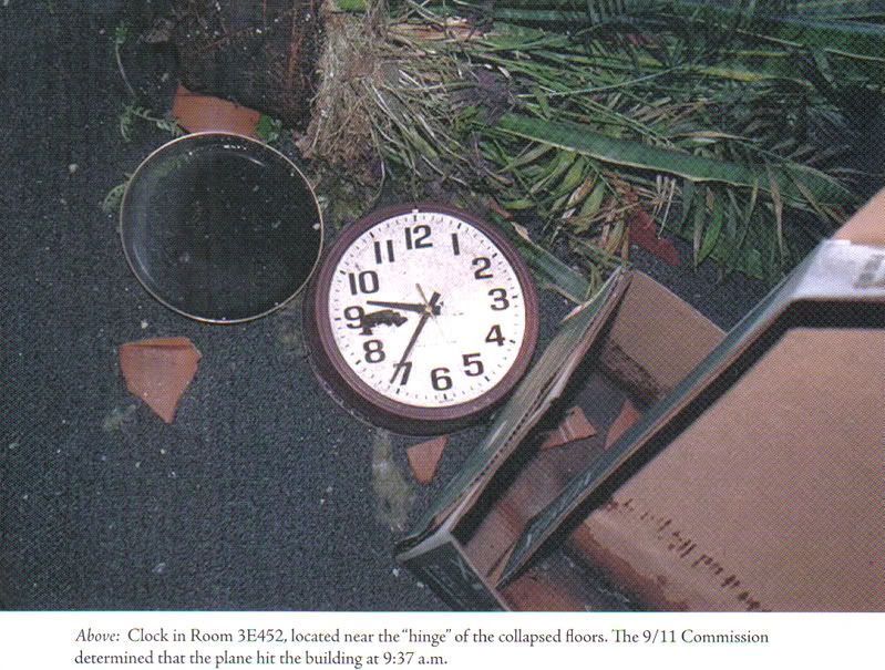
Ironically enough, the famous 9:30-ish stopped clocks, which stand as the best (basically only) evidence for a blast at that early time, may also support the 9:38 time-frame. Non-nutty 9/11 Truther Russell Pickering decided that the low time is a case broken mechanisms as the clocks hit bottom-first after falling from their mounts, with simple gravity responsible for pulling the hands down to near bottom. He issued a challenge for anyone to take, which no 9:32 event supporters did, For one, CIT ally Mirage of Deceit (nutty) later confirmed the results (link unavailable). The pictures indicate the minute hands were somewhere past the 6, not before, but little else can be said for sure. But since everything else says it all went down at 9:38, is it not reasonable to call these a double-confirmation of that time with gravity rounding it down towards 9:30? [note: although it seems to have fallen differently and onto carpet, a similar effect could be behind the above clock’s being behind – or perhaps someone at the Pentagon actually was synched over a minute behind.]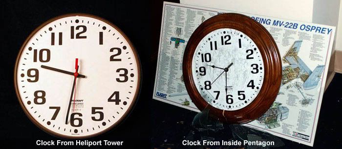
Case Closed
So now that the 9:38 case looks strong enough to actually absorb even the best early-attack evidence, I’d like to turn to some assorted other evidence that doesn’t fit, and for shits and giggles use it to craft smtig even stupider than the 9:32 Pentagon attack meme (which CIT doesn’t even buy). Who knows, some bold Truther might just run with the 9:30-or-before scenario (oops, they already have) or the 9:25 WTC attack (no takers yet).
Adam Larson / Caustic Logic
The Frustrating Fraud
August 7 2008
Last Updated 8/10/09
For those who see no reason to question the official time of the Pentagon attack, this post will be unnecessary. But for those confused by claims of different times, primarily 9:30-32 am, this may prove quite useful. If you're willing to learn... (sigh). Of all the times cited for the impact/explosion/whatever at the Pentagon on 9/11, one stands above as the most-cited, most-supported, and most-likely true – by this I mean, approximately, 9:38 am. Officially the explosive impact of Flight 77 is given as 9:37:45 or :46 based, it seems, on the Flight Data Recorder. In reality, the impact time is impossible to pin down exactly, but likely a bit after this, probably between 9:37:50 and :55 (see FDR section, first up). Following is a nearly-comprehensive list of the most direct evidence establishing the impact at right around that time.
1) Flight Data Recorder:
Much rhubarb has been made of the information on Flight 77’s Flight Data Recorder and how it doesn’t match the reality necessary to get it inside the Pentagon where it was said to be found. The last frame of data recorded is 9:37:44 or :45, depending on the exact file one’s looking at. While this is officially the moment of impact, the recorded values do not match those evident in the physical damage (most important – too high!) This is taken by some nitwits/liars as proof the plane didn’t hit. Another view takes this as a clue that this last data is actually NOT from the moment of impact, but a mile or more back, as the INS positioning says (it’s prone to error of about 1/2 mile I hear). Most analysts have come to this realization, though opinions differ on how far back, how much data is missing, and why (which is beyond the scope of this piece). Estimates range from 2 to 10 seconds remaining to impact at last frame, with the upper end of 8-10 seeming most likely to me, and placing impact at 9:37:50 or later. This slight variation of the “official” time alternates with it in the list below and illustrate that roughly all evidence points at a roughly 10 second time range best rounded to the minute as 9:38.
2) Radar: We’ve always heard the radar data supported and defined this impact time, but fact is it can’t tell us exactly when, or even if, the plane impacted. The raw data of the Air Force’s 84th radar evaluation squadron (84RADES) was released in 2006 to researcher John Farmer, showing all returns from the DC area on 9/11. As I understand it, ‘blips’ are sent and returned every 12 seconds; the last three attributed to Flight 77 are at 9:36:48, 9:37:00, and 9:37:12 (see graphic at right, from Marco Bolletino’s reconstruction of the data). Before the next return, the airliner dropped below the coverage level of app.2,000 feet above ground [this altitude is passed by FDR about 9:37:18]. There is an established NEADS clock issue, known to be app. 25 seconds slow relative to other clocks in the FDR and at ATC facilities. Therefore, the last return would actually be at about 9:37:37, with impact presumably some seconds after that. This support is vague but would hint at an impact somewhat later than the official time less than ten seconds hence. On the other hand, the FDR pressure alt for 9:37:37 is 786 ft AGL, which seems too low to be just disappearing from radar. Perhaps I’m confused on the timeline discrepancy. Anyway, it’s all there… it doesn’t prove a 9:38 impact, but it fits it just fine.
1a+2a) FDR/Radar Combo:
In its Final Report, the 9/11 Commission gives the impact time of 9:37:46 [p 96], citing as its source NTSB report, "Flight Path Study-American Airlines Flight 77," created Feb. 19, 2002 by the National Transportation Safety Board. The full document in question is available in PDF form [here. The report in turn lists its sources as FDR data “as well as” (implying no conflict with) “radar data from the Federal Aviation Administration’s Air Route Traffic Control Centers, approach control at Washington Dulles Airport, and the U.S. Air Force’s 84th Radar Evaluation Squadron.” [This is the data examined above]. From this, the report summarizes that “the airplane accelerated to approximately 460 knots (530 miles per hour) at impact with the Pentagon. The time of impact was 9:37:45 AM.” Ooh! A one-second discrepancy! And both were likely a bit early, with the Commission closer it seems.
3) Arlington County Emergency System:
From Arlington County After-Action Report, and its first-hand access to emergency communications , we can see that key information was called in just before and after the 9:38 mark, and reactions followed in the next minutes, as recorded and logged as at a time generalized as 9:38. [emph mine].
“In the moments immediately before impact at the Pentagon, the Arlington County ECC began receiving 9-1-1 calls reporting a low flying airliner that seemed off the normal flight path. When the crash actually occurred at 9:38 a.m., all area communications seemed simultaneously overwhelmed. Firefighters calling the ECC couldn’t get through. Relatives of Pentagon workers found cellular and land lines jammed. Emergency traffic flooded radio channels.” [page A-34]
“Captain Steve McCoy and the crew of Engine 101 were […] traveling north on Interstate 395 [when they saw] a commercial airliner in steep descent, banking sharply to its right before disappearing beyond the horizon. At 9:38 a.m., shortly after American Airlines Flight #77 disappeared from sight, a tremendous explosion preceded a massive plume of smoke and fire. Unable to pinpoint the precise location, Captain McCoy immediately radioed the Arlington County Emergency Communications Center (ECC), reporting an airplane crash in the vicinity of the 14th Street Bridge or in Crystal City.” [page A-34]
At 9:38 a.m., a large smoke plume appeared beyond the Rosslyn skyline. Arlington County Police Corporal Barry Foust radioed the ECC that he saw an American Airlines jet crash into the Pentagon. The ECC swung into action [page A-35] […] [B]etween 9:41 a.m. and 9:43 a.m. on September 11, the ECC Administrator, Steve Souder, acting on his own initiative, contacted the Fairfax, Alexandria, and District of Columbia fire departments. He gave them identical instructions: deploy four engines, two trucks, one rescue unit, four EMS units, and a command officer to a staging area short of the Pentagon and hold them there until called forward.” [page a25]
4) C130 pilot report via FAA:
The 9/11 Commission briefly discussed the “second plane” at the Pentagon, a C-130H cargo plane dubbed “Golfer 06.” The Commission noted on page 26 of their final report:
“At approximately 9:38 A.M., the C130H aircraft reported to Reagan Airport controllers that the aircraft it was attempting to follow crashed into the Pentagon.” The source is given as “FAA audio file, Washington Tower, Tyson/Fluky Position, 9:38:52 .-M.; FAA letterhead memorandum, 'Partial Transcript; Aircraft Accident; AAL 77; Washington, DC; September 11, 2001,’ 7.
Although the two planes had crossed path just a minute before, both radar and the pilot’s own words agree that Golfer 06 was too far away to see Flight 77 itself at impact, but was close enough to see the smoke and to know where it was coming from. Certainly the impression was there from the beginning, and was only confirmed as it approached at 9:38, passing nearest to impact point at 9:39:15, after which it veered off to the north and west and continued on to witness the crash site of Flight 93 as well before reaching base in Minnesota.
5) 9:39 News Report - NBC:
Among the most solid clues to at least the general time of the attack of the Pentagon attack is in NBC News coverage of the 9/11 events. [video link - when watching the video, note that it starts at 9:12 am, so the video time is to be added to this for the real time] At perhaps 10 seconds after the 9:39 mark [26:24 video time], the newsroom interrupted its coverage to let Pentagon correspondent Jim Miklaszewski bring them their first news of something awry there. He told the nation:
"I don’t want to alarm anybody right now, but apparently - it felt, just a few moments ago, like there was an explosion of some kind, here at the Pentagon.” He explains he was on the east side of the mammoth building, opposite from the impact, so it was a big explosion. He saw no smoke from his side, inside the E ring, and didn’t know what was going on. “I just stepped out in the hallway, security guards were herding people out," he explained, meaning some time at least had elapsed. So far impact is looking to be one minute, 15 seconds before this broadcast. Sounds like “moments” to me.
6) Security video time stamps – Pentagon, Doubletree, Citgo:
Though neither the Citgo or Doubletree videos, released in 2006, shows the official time in their on-screen clocks, both timers roughly bracket it: Doubletree – 9:34:10 impact (app 3:35 behind) Citgo 9:40:36 (app 2:51 ahead)
It’s a very small sample to be conclusive, but this is what’s called a normal distribution, that sets a center point of app. 9:37:00. That’s pretty close for a sampling of two clocks, one of which also bears the default date of Jan 1 1993 [for a clue to the professionalism and precision of their deployment].
Regarding the time stamp of the Pentagon’s own CCTV gate cameras that famously captured the plane and impact, Col. Alan Scott told the 9/11 Commission in May 2003:
“The timeline on the impact of the Pentagon was changed to 9:37 -- 9:43 is the time that was reported that day, it was the time we used. And it took about two weeks to discover in the parking lot of the Pentagon this entry camera for the parking lot, which happened to be oriented towards the Pentagon at the time of impact, and the recorded time is 9:37. And that's why the timeline went from 9:43 to 9:37, because it is the best documented evidence for the impact time that we have.” [source]
It should be noted that the time stamp is not reproduced on-screen. The initial five released framed show a time of the following evening Sept 12 – much to the delight of mystery-mongers, it’s more likely the time the frames were processed and labeled “plane,” “impact,” etc… but they seem to have been recorded in the 9:37 slot on the correct day, and were in fact instrumental in setting the time initially. We find later it’s actually near the end of that minute, but still technically not 9:38.
7) Eyewitnesses:
Considering the known unreliability of eyewitness recollection, and that most people do not directly time-stamp their memories, it should not be surprising that this sector of the evidence is the least clear on the actual impact moment. Just a few of the published accounts provide useful clues, while many specifically disagree or are hopelessly vague. The oft-cited “9:30” is too common a rounding point to be taken too seriously, and it appears several times. A small sampling that are said to specifically cite something more like 9:32 were outlined in a previous post. But the sampling of five below does establish a normal distribution around the minute all other evidence is pointing at.
“It was about 9:35 […] it came from the south. […] I watched it come in very low over the trees and it just dipped down came down right over 395 into the Pentagon.” – Don Wright
“At 9:40 a.m. I was driving down Washington Boulevard (Route 27) along the side of the Pentagon when the aircraft crossed about 200 yards… in front of me.” - Donald R. Bouchoux
“At 9:35 a.m., I pulled alongside the Pentagon. With traffic at a standstill, my eyes wandered around the road, looking for the cause of the traffic jam. Then I looked up to my left and saw an American Airlines jet flying right at me.” - Vin Narayanan
“At 9:35, as we were watching this on TV, we heard over the loudspeaker “All medical personnel report to the front desk of Medical.” We did not know at that time that the Pentagon had been hit.” - Captain William B. Durm
“About 9:30 or so — I don't know the exact time, maybe quarter to 10 — we were still in the conference room, and we heard and felt the loud explosion of the plane hitting the Pentagon, and it reminded me of an earthquake.” – Lt. Col. Frank Bryceland [note: the mid-point of the range from 9:30-45 is 9:37:30.]
Update:As the brilliant JREF member Mangoose pointed out to me a while back:
I would also draw your attention to the witness account of William Paisley who posts as Pinch at JREF and who has a blog http://www.instapinch.com/.
You might want to contact him directly but he has elsewhere related that he was at Crystal Park 3, 10th floor on 9/11, and was watching NBC coverage of the terrorist attacks; when he saw Jim Miklaszewki's report at 9:39:10 he took a few steps to his office window and immediately saw a billowing, building mushroom cloud of black smoke rising up above the roofs of the buildings between his building and the Pentagon. This is pretty good confirmation that the explosion was not too much sooner than 9:39.
8) Wall clocks at the Pentagon:
In the Book Pentagon 9/11 [Goldberg, 2007] is pictured a wall clock from an office above the impact area, stopped at 9:36:27 – one minute, 25 sec behind the time in discussion. This is reasonably close and solid evidence of the general time at least.
Ironically enough, the famous 9:30-ish stopped clocks, which stand as the best (basically only) evidence for a blast at that early time, may also support the 9:38 time-frame. Non-nutty 9/11 Truther Russell Pickering decided that the low time is a case broken mechanisms as the clocks hit bottom-first after falling from their mounts, with simple gravity responsible for pulling the hands down to near bottom. He issued a challenge for anyone to take, which no 9:32 event supporters did, For one, CIT ally Mirage of Deceit (nutty) later confirmed the results (link unavailable). The pictures indicate the minute hands were somewhere past the 6, not before, but little else can be said for sure. But since everything else says it all went down at 9:38, is it not reasonable to call these a double-confirmation of that time with gravity rounding it down towards 9:30? [note: although it seems to have fallen differently and onto carpet, a similar effect could be behind the above clock’s being behind – or perhaps someone at the Pentagon actually was synched over a minute behind.]
Case Closed
So now that the 9:38 case looks strong enough to actually absorb even the best early-attack evidence, I’d like to turn to some assorted other evidence that doesn’t fit, and for shits and giggles use it to craft smtig even stupider than the 9:32 Pentagon attack meme (which CIT doesn’t even buy). Who knows, some bold Truther might just run with the 9:30-or-before scenario (oops, they already have) or the 9:25 WTC attack (no takers yet).
Sunday, June 1, 2008
THE FLIGHT DATA RECORDER {masterlist}
A BLACK BOX SURROUNDED BY A MOAT OF MYSTERY
Adam Larson
Caustic Logic / The Frustrating Fraud
last update 8/24/07
Last updated 3/4/08
Much Ado About... Nothing?
Much has been made recently of the reconstruction of data from Flight 77’s Flight Data Recorder, the so-called black box found at the crash scene inside the Pentagon. The "9/11 Truth" analysis of the data is largely based on the fragmentation of the supposedly coherent data in the flight data recorder (FDR) of the attack plane – different versions have appeared, between which different parameters are found to be "altered," leaving each piece neither totally false and dismissable nor totally true and acceptable. Thus they hover in a middle space to be analyzed by experts – primarily Pilots for 9/11 Truth and their expert allies. Predictably, the data as read and shared offers different answers to different questions at different times, depending it seems on the circumstance. The answers consistently challenge the official account, but fail to prvide a rational alternative, and often conflict with each other…
Various aspects of the NTSB animation based partly on the FDR are covered in my three-part video series "That Darn NTSB cartoon," compiled with notes here.
--- About the Sources ---
- The Evidence Trail - NTSB, FBI, 9/11 Commission, and the National Security Archive keeping the data under wraps, and its final revalation to the public in mid-2006.
- The FDR Specialist's Study: A closer look at the verifiably NTSB-provided FDR data.
- The CSV file
- "Three CD's: Where's Snowygrouch's DVD?" The Pilots' Transatlantic animation connection examined. Snowygrouch and the animation's first appearance. NTSB status at the time: unclear IMO, and yet...
--- Analysis ---
- Pilot X and the 440-foot gap: Altitude Questions raised by the NTSB animation
- Created in Translation: the altitude re-set NOT in the animation - where is it then? at FL018... forthcoming
- A somewhat dated but interesting analysis thread by myself and others @ Above Top Secret: Great insights, explanations, obfuscation, and fumbling with appearances by John Lear, John Doe X, and others.
- Ten Degrees From true: THE "NTSB Animation" is Flat Wrong Demonstrating that the north of the Citgo flight path shown is in fact at least 20 degrees off from the Black Box data it's supposed to be based on.
- Final Altitude: Eight Readings: At least four altitudes attributed the the FDR, compared to flyover "witnesses," and the "official story." I did forget radar accounts which place altitude by accounts of it dropping beneath their coverage just before impact. This is said to confirm the official story and probably does.
- 20 Minutes and 20 Miles from True: CSV longitudinal offset
- NTSB animation internal geography {masterlist} My most tedious chapter yet - five posts with one or two more to come.
- A Turn For The Worse: The culmination of the animation studies above: visual proof that the animation's final overlay map is rotated to about the same tune the plane appears north-of-the-Citgo.
- Csv/animation altitude discrepancy. Kind of a mess, mostly intended as a self-correction.
- CSV final plots: Using timeline seconds to determine geographic seconds.
- Missing Seconds: My Last FDR post
- Bank Notes: Draws on FDR bank/roll readings as part of a larger argument
--- My own NTSB FOIA Search ---
- News Coming A half-ass rundown of why I was finally contacting the NTSB.
- NTSB FOIA Response recieved - no discs enclosed
- NTSB's "Goebbels" and Me When I talked to the director - not important but a tad interesting
- Video: That Darn NTSB cartoon part 2 - the Authenticity Sidetrack Snowygrouch et al. and my discless response explained by me in a video.
Monday, April 14, 2008
NEADS DATA TIMELINE ALTERATIONS
NEADS DATA TIMELINE ALTERATIONS
Adam Larson / Caustic Logic
The Frustrating Fraud
April 14 2008
edits 4/15 2am
No matter how much I look into it, there's plenty about the Pentagon attack and the evidence around it that's over my head. I'm no expert, but also naturally suspicious, and fear linking to erred or dishonest findings. So naturally I shy away from citing 'expert X' on whatever (especially those with "x" at the end. Or "amo.") unless I can understand the issue myself at least enough to say whether the assertion makes sense. But John Farmer's work has proven more than worthy of mention even if I haven't verified it myself. And it's occurred to me that people shouldn't only come here for the 'convoluted' results of my own analysis and findings.
In that spirit and because of its relevance to the other evidence, I must finally mention a discrepancy Farmer had previously identified - a 25.3-second timeline difference between real time/FDR and the clocks used by NEADS (Northeast Air Defense Sector) on the morning of the attack. This had previously been noted by the 9/11 Commission and borne out by comparitive analysis, and now he's elaborated on that with some additional FOIA-released information and more study.
NEADS 25.3 Second Time Difference Explained He found evidence about the NEADS clock that, rather than a steady uniform time difference:
"The patterns in the chart indicate that the NEADS radar data was NOT real-time and real-world. The pattern clearly indicates at least 3 different processing units were being used to process the data between the time it was collected at the radar site and then fed to the end-user (in this case the data files). This fits with the fact that “exercises” were running that day, but it also brings the entire NEADS segment of the data into question. I would suggest that researchers compare the NEADS radar returns with those in the SEADS databases (which appear at this point real-time) whenever possible."
I still don't get the whole thing but I'll be darned if this doesn't sound very interesting. Processing units? For NEADS, where the whole attack happened? How was the radar data being processed? Please keep an eye on this issue, in case I don't ever figure it out and 'clarify' it for everyone. Okay, everyone figure it out well in case of that eventuality, so people can set me straight right quick. ;)
Tuesday, January 29, 2008
FARMER LEGAL ACTIONS - UPDATE
I'd been meaning to do a piece on John Farmer's continued FOIA follow-up and recent legal actions to get ahold of the non-truncated serial bit stream original FDR file from Flight 77. He had previously found up to six seconds of data missing, and my humble math in fact shows something closer to eight seconds gone, both of which are well beyond normal, expected data loss. For whatever reason, it sniffs of willful deletion, and his previous requests had the NTSB insisting to original data these incomplete interpretations were made from DOES NOT EXIST, indicating it was perhaps destroyed, in violation of federal law. So without any further confused commentary, here is the news I just received via e-mail:
---
For Immediate Release
Memphis , Tennessee
January 29, 2008
Important 9/11 Court Action
Memphis , TN - On January 29, 2008, a Complaint for Injunctive Relief was filed with the United States District Court for the Western District of Tennessee located in Memphis , Tennessee against the following defendants:
NATIONAL TRANSPORTATION
SAFETY BOARD
490 L’Enfant Plaza, SW
Washington , DC 20594-0001
U.S. DEPARTMENT OF JUSTICE
950 Pennsylvania Avenue, NW
Washington , DC 20530-0001
U.S. DEPARTMENT OF TRANSPORTATION
1200 New Jersey Ave, SE
Washington , DC 20590 .
The complaint seeks records pertaining to the recovery and custody of the flight data recorder from American Airlines Flight 77 from the NTSB and FBI, and a copy of the original serial bit stream (binary 1’s and 0’s) in waveform format. It further seeks the radar data from Andrews AFB, Dulles and Reagan International Airports in the custody of the FAA.
In the complaint, John Farmer states that he “believes that the defendants are purposely delaying and avoiding the release of these records to the public.” The full text of the complaint may be viewed at www.aal77.com.
Blue Collar Republican
bcr@bluecollarrepublican.com
www.bluecollarrepublican.com
901-848-9194
---
complaint PDF download link.
---
For Immediate Release
Memphis , Tennessee
January 29, 2008
Important 9/11 Court Action
Memphis , TN - On January 29, 2008, a Complaint for Injunctive Relief was filed with the United States District Court for the Western District of Tennessee located in Memphis , Tennessee against the following defendants:
NATIONAL TRANSPORTATION
SAFETY BOARD
490 L’Enfant Plaza, SW
Washington , DC 20594-0001
U.S. DEPARTMENT OF JUSTICE
950 Pennsylvania Avenue, NW
Washington , DC 20530-0001
U.S. DEPARTMENT OF TRANSPORTATION
1200 New Jersey Ave, SE
Washington , DC 20590 .
The complaint seeks records pertaining to the recovery and custody of the flight data recorder from American Airlines Flight 77 from the NTSB and FBI, and a copy of the original serial bit stream (binary 1’s and 0’s) in waveform format. It further seeks the radar data from Andrews AFB, Dulles and Reagan International Airports in the custody of the FAA.
In the complaint, John Farmer states that he “believes that the defendants are purposely delaying and avoiding the release of these records to the public.” The full text of the complaint may be viewed at www.aal77.com.
Blue Collar Republican
bcr@bluecollarrepublican.com
www.bluecollarrepublican.com
901-848-9194
---
complaint PDF download link.
Friday, November 30, 2007
MY INFAMOUS PENTACON REVIEW
MY INFAMOUS PENTACON REVIEW
Adam Larson / Caustic Logic
The Frustrating Fraud
November 28 2007
working copy - last update 12/4 2 am
---
Introductory Note: This is not exactly the original as I posted it – I seem to have lost that unfortunately. But this is a version before I added some alterations to appease Craig Ranke/CIT and before I finally pulled it (back in July) for causing too much friction for my liking. I’ve repeatedly been accused of ‘conceding’ that my review was unjustified, etc. by virtue of pulling it, and this has been used by CIT to attack me as a disinfo/COINTELPRO/operative, or brainwashed nimrod sent to neutralize them, or whatever. This has some good reason, like that I attacked them first with the now-infamous phrase “Pentagon-sponsored disinformation.” This line is oft-quoted by Craig to justify his stance towards me. I honestly have no personal problem with their whole hard truth warfare thing (though it is troubling when coupled with other observations, like thse below). So for the record, I re-post it here in its original context with all typos and errors left in but notes added in this format.
And keep in mind I had just seen the video a couple of times and had little background information and somewhat less knowledge of all evidence in general. I was pretty sure a 757 impacted, but a bit stumped by the coherency of the north path testimony, and all I could really think of other than me being wrong on all points was coordination – and I said so. But the strength of Craig’s response, and too much attention on a piece that I didn’t write all that well left me embarrassed and wanting to pull it. But with the advantage of another nine months-worth of knowledge, I regret my initial suspicions less and less, and either way, in the interest of clarity, here is what I said before these guys ever had said a word to me.
---
VIDEO REVIEW: THE PENTACON
Caustic Logic is forced to review: "The PentaCon: Eyewitnesses Speak, Conspiracy Revealed" (smoking gun version)
Update: March 5 2007
This rather troubling video opens with a CG rendition of the Flight 77 “flyover maneuver,” followed by the opening credits, which announce solemnly “Citizen Investigation Team is forced to present” … a grisly, over-the-top montage of foreign people killed at the hand of the US military. All this murder, justified by imperial greed and… the PentaCon! Both the video’s graphic fixation with the physical building and with the sins of wars planned from within those five rings, immediately bolsters my gut reaction that this is indeed Pentagon-sponsored disinformation. With this attitude wrapped around and supported by another set of dissolving claims, the video’s title is apt either way.
---
Note: I certainly don’t mean to belittle the suffering unleashed by the “World War IV” made possible by 9/11 and its string of unlikely 'failures.' I simply take issue with their manipulation of the emotional urgency this lends the debate to try and ram their conclusions through the BS detectors of ‘9/11 Truthers.’ Though true motives are impossible to divine for certain, the tingle of disinfo I got was real and has its reasons: as I added in a later update, this would serve as “a possible self-aggrandizement sarcastically disguised with demonization,” and using the anti-DoD citizen team would effectively mask the operation, if not a little too perfectly. Or it could just be my paranoia. Whatever.
---
The first several minutes are spent with Aldo Marquis’ exceptionally smooth and relaxed voice endlessly setting up the official flight path, showing repeatedly the soon-to-be damning cover-story testified to by government lies and the physical evidence. This is said to conflict with just-discovered eyewitness accounts that again “prove” that, whatever exactly happened on 9/11, no 757 hit the Pentagon.
I watched the shorter, “smoking gun” version of the PentaCon, which promises to be far more popular than the longer research edition.* This one hour, twenty minute work draws on four separate accounts that place the attack plane unequivocally on a flight path different from the previous official one, well to the north and thus incapable of clipping the light poles on the official path or causing the extensive damage to the building’s lower floors. The main points giving these accounts enough weight to counteract the others we’ve heard, as Marquis listed them:
---
* Note: As of November, still not released.
---
1 – The four accounts jibe with each other – at least on the one pivotal point they focused on, though on other points they still disagree, their flight paths don't match up terribly well (see below), and their descriptions of the plane differ.
2 – The question is simple – was the plane coming in to your right or left? (and which way were you facing? Oh wait, was that before the plane… no wait, I was over here, then…)
3 – The witnesses had the “best possible” vantage point to see the attack – not exactly, but three of the four had pretty good views.
4 – The witnesses are credible; two of them are Pentagon cops! *
5 – Their testimony was filmed on-location to accurately re-enact and recall what they saw, and besides...
6 – Everybody remembers 9/11 clearly, especially if they happened to see an off-white United Airlines 737 hitting the Pentagon from the northwest.
* Note: The other two have nothing like Defense Protective Services employment to cast leverage on their recollections, since they are naturalized immigrant citizens, with no secret, threatened deportation hearings or anything, or so we should presume.
---
1) Edward Paik, an auto mechanic, was working at his shop just west of the Navy Annex, and saw the plane fly right over him and very low over the surrounding rooftops. His only salient description is of black wings (shadow? He would’ve seen it from below). His English proficiency is limited, and he seems a bit confused in his awkward, eight-minute testimony to Ranke, trying to keep his clipboard at one point. His account, all in all, placed the black-winged plane on a near-straight line from south of the Navy annex, the closest of the four to the official story, but sending it north of the Citgo.
---
Note: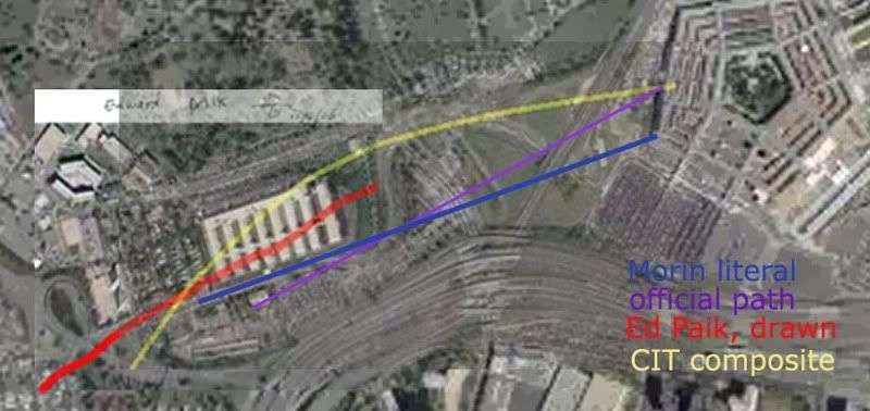 New graphic – Terry Morin’s account read literally (ie, wrong), the official path borne out by much evidence, Paik’s drawn path across the annex, and the CIT composite path merged from their four main witnesses. Note the different elements each got right or wrong; north-south location and compass heading. It’s my firm belief that Paik and Morin saw the same thing but just decribed it differently enough to create two out-runners near the official path, and that CIT took the northernmost of these two and morphed it yet further north to fuse with thir three main witnesses, below.
---
2) Robert Turcios was at work at the Citgo station when he saw a large, twin-engine, wide-winged “gray” plane. He later clarified it was more silver, with no markings he remembered, which is roughly consistent with American Airlines’ nearly-paintless paint job. He was 100% certain it flew on the north, though he saw no light poles hit in the perhaps one second the plane was visible. Shortly before the building, he saw the plane pull up over a 20-foot-high over-road traffic sign - and thence, one would think, over the building. Turcios seemed confused and a bit annoyed when Ranke asked about a flyover and/or second plane; as Marquis’ voice-over explained, the witness still believes the silver jet hit the building, even though his account makes it “impossible." The subtle implication seems that Turcios is an idiot, but if pressed, the CIT folks would probably say he just had to believe it hit but that this bias does not adequately mar his testimony.
Note: Turcios' testimony had him at the station's south end, and running up the little mound to see the plane pull up. This is not shown in the proper view of the Citgo security video, which CIT strenuously denounce as irrelevant evidece regarding their Citgo-centered case. It was an anti-Turcios smear, they insist, first released just ten days after they first announced on September 5 2006 that they had a north path witness. As Craig explains, the video release was “done to discredit Robert Turcios since he is not visible in the video.” Another possibility is the video is real and their witness was simply not there to do what he says he did and his testimony is bogus. And again, besides Robert not being represented, there is a large shadow inserted consistent with a plane to the south of his (reported) position, when he had indicated it was just north. Proven manipulated? They had better hope so.
Some observations on Turcios’ account: was he even outside the station?
A unique intuitive reaction to the Turcios interview by StevenWarRan (apparently no longer up) noted the subject “gets upset in direct proportion to the pressure placed on him to say a certain thing in a certain way, I saw a common attribute hidden by its obviousness: the quick ins and outs, sometimes only a few words long, without any continuity, like computer viruses battling.”
John Farmer flash presentation: I’m not sure this is really Turcios here but it’s interesting nonetheless.
---
3) Sgt. Chadwick Brooks was a Pentagon police officer on patrol at shortly after 9:00 am, when he pulled into a parking lot next to the Citgo to catch news on the New York attack. After he'd been there a while, the plane suddenly came in from the west, to the north of the station. He saw impact and fireball, presuming that the plane impacted building, but saw no light poles hit. He thought it was a 737, and emphasized to Ranke the plane’s size and large number of people on board. He saw no second plane.
The oddest part of Sgt. Brooks’ account is his recollection of the plane’s color, described as off-white or “champagne.” He thought markings were of a United Airlines plane, with blue letters, but UA planes have distinctive dark blue and mid-tone gray color schemes. And no one else has described a United plane, the official one of course being a red, white, and silver AA plane. Is he inserting the color scheme to fit with the airliner he thought (from news reports) had hit the building? Ranke doesn’t probe the sergeant on this, and the narrator fails to point out or explain anything as far as inconsistencies, instead moving on swiftly to their obviously favorite witness...
---
Note: The silver-white problem has been worked out – CIT has decided the plane is now white, the flyover white jet that apparently came down the river and looped in from the southeast and then north of the Citgo. Apparently anyone who said silver meant white, and anyone who said white (or near white) meant white, not silver. Lettering and design color issues are probably addressed somewhere too. I'm behind on the specifics here.
---
Sgt. Lagasse and Brooks at the Citgo. Brooks has just drawn his flight path for Ranke.
4) Sgt. William Lagasse, a pentagon police dog handler, provided a rather solid presence to the northerly flight claims, having been already famous (in some circles) for his earlier testimony of the attack; the son of an aviation instructor, and familiar with all major plane types, he instantly identified the culprit undeniably a a silver AA jet, probably a 757. He had his dog in the car, which he was filling up at the Citgo station after chatting with some cops about the NY attacks, when he saw the blur perhaps 100 feet up and then heard it swooping down, in less than a second exploding against the building. No flaps or landing gear were down, and he could see shades pulled down on the windows as it came in from the north. He was pretty sure it actually hit with a “yawing” motion, having observed no pull-up. He saw no light poles seeing hit, but there were ones down so he presumed they were cut by this plane. He’s 100% “bet my life on it” certain that the plane flew over his left shoulder into the building, placing it to the north. Ranke did risk upsetting his interviewee by presenting him with a picture showing the clipped light poles, but Lagasse refused to believe it. Indicating the official flight path, he insisted "nothing happened over here. Period."
---
Note: Lagasse is not suffering from vague memory, but specifically wrong memory. He specifically pointed out on a map where at least two poles were knocked down on his path that did not happen. Indicating the area he would have had to drive right through to get there, he said "none of these light poles over here were knocked down. They were here. NONE of these were knocked down." He also indicated Lloyd’s cab in that area, hundreds of feet from where it really was. CIT chalks this up to denial-driven memory alteration. Anyway, when Craig says the 'official story' put the pole damage further south, Lagasse responded - incredulously - “what official story? The only official story would’ve been the Arlington County Police Report done after the event. There’s no official story other than that. That’s the After-Action Report that was written by Arlington County.”
Just from this, it seems Lagasse feels it supports his north-side recollection. If he hadn’t studied it closely before speaking, he should have, because then he’d know how deep the ‘cover-up’ went. The text is rather vague on trajectory, but in several graphics throughout it indicated the official path (arrow at impact point) and clearly lines up with what Craig termed the official story. (note location of "forward assessment") The downed poles are on this path. Did Lagasse never see this and have his memory jogged? ‘At the cloverleaf? Oh yeah, that IS where the cab was…’
---
Lagasse also initially took them to the wrong spot, but then recalled on-camera his backing out from a different pump than he thought he was at, which Ranke notes with relief, as his testimony then matched his patrol car pulling out as captured on the Citgo’s security cameras. Lagasse had earlier cited that he was seeing the plane from the right side, meaning it was to his left, or north. This account at least is consistent with earlier, known testimony, but he clearly does not buy the no-757 theories, having repeatedly attacked the previous flyover theories of Dick Eastman. He can't be happy that his testimony is now being used to bolster - and quite well - another flyover theory. Or perhaps he's just doing his job as a link in the Pentacon disinfo web, having earlier earned anti-CT credentials in his spats with Eastman.
---
Note: This fascinating 2003 analysis by Jean Pierre Desmoulins helps shed some light on the Eastman/Lagasse back story. This discussion has flared up time and again (like here). Craig has informed me, based on his assessment of possible motives, any such conspiracy theorizing is loopy, unsubstantiated, and so nuts he was being responsible in never bothering to consider it. Regarding this possibility of organized, malicious error in the accounts, I recently asked Craig “why have you have (so far as I’ve seen) never addressed this possibility at all until forced to? If you have ever publicly aired doubts about the main content of their accounts, or the possibility of systematic deception, now’s the time to link to it. Otherwise, embracing one ridiculous possibility as a ‘smoking gun’ while rejecting another without even bothering to explain why, to dismiss it as if it never existed, is a rather suspicious way to carry out an investigation.” He responded “The notion is so completely absurd that my answer is an emphatic NO. Nobody who went through what I went through would consider such a ridiculous assertion.” Is this an admission that he’s simply too deeply invested to turn back now? If so, he and Aldo had to both just not consider it at the beginning either, at least long enough to get this far ahead.
---
In concluding and synthesizing the accounts, Marquis explains some of the reasons the witnesses think the plane hit the building; they had been conditioned by news from NY to expect a plane to hit a building. This helped mask the plane’s flyover, and on the other side of the synchronous blast the plane simply blended in with normal air traffic, just nine minutes after all commercial flights were ordered to land, and slipped away in the rapidly thinning crowd to its own secret touchdown.
---
Note: As of writing, no other-side witnesses witnesses testifying a flyover have yet surfaced. One attempt at finding one is “Barbara,” whom Woody Box presented as "a witness detected by ME to counter [the] claim that the flyover was observed by NOBODY." On 395 near the Potomac, Barbara saw "on the left-hand side, there was a commercial plane coming in, and […] we saw […] it go down below the side of the road, and we just saw the fire that came up after that. […] I'm not sure exactly where the Pentagon, where it was in relationship to where the plane went down but they are relatively close to one another. ... whether it hit any part of that pentagon, I'm not sure." Going down and crashing doesn't sound like a flyover to me, but WB thinks it happened just on the other side, perhaps in the Pentagon's lagoon. Even considering this confusing and misread account, there is no direct evidence for a flyover anywhere, just the partial implications of the collected witness accounts CIT keep getting.
---
The video also cites report of a second plane just seconds behind the explosion, which then veered off. These reports could've been those who saw through the con and witnessed the explosive "impact" and the plane flying off, but their presumption of two planes, in the official story, was then quickly “turned into” the attack plane and the C-130 ordered to scope the scene. But the C-130 was not seen until at least a minute later, so the “second plane” people saw was the flyover jet fleeing the scene. As for the identity of the flyover fool-people plane, the CIT’s investigation had decided on a hybrid plane with some AA features as the most likely possibility, perhaps a re-painted E4B airborne command center plane, since another one of these painted pure white was also seen in the area.
---
Note: They do not claim an E-4B, as I cited below, since no witnesses describe a 4-engie plane. However they do still claim the C-130 was sent in to confuse people who witnessed the flyover – it appears over the immediate area by radar and video about 2 min post-impact and way up there. Little confusion possible unless reports with things like 'moments later" are read too literally the wrong way. While the newly-released radar returns of the area matches an amteur video for C-130 path and time, but contradicts with recent testimony of the C-130 pilot given to Rob Balsamo and verified with CIT via e-mail. With this flightpath untaken in the CIT construct, its rough contours have been attributed to the charter boat captain's sighting of the white jet that then circled north and presumably flew over. I'm still hazy on this point, but something clearly isn't adding up. [graphic forthcoming]
---
So besides the flyover AA-painted E4B and the later C-130 scoping out the area, there would have to be another explanation for both the light poles and the building damage. I had initially seen this as their weak point and wondered how they would handle it, but was rather surprised at the inadequacy of their explanation. On-site bombs were used to fake the airliner impact and the 300-foot-deep penetration into the building, the space that would later be filled with planted bodies, plane parts, and the very FDR that would “prove” the plane never hit the building. The tops of the light poles, marquis explains, were torn off at some earlier time and simply planted near their mangled bases, perhaps the night before, except the one that allegedly hit the taxi's windshield, but the hood was not dented also so clearly the ploe didn't fall on the car. I guess he jumped out and smashed the windshield himself just as the feds dopped the pole next to the car.
---
Note: This whole issue is very complex and my understanding of the taxi-pole issue is still only partial, but it seems to me driver Lloyd’s account does not add up. I’m far less certain than CIT as to what this means, however, and the rest of their physical case – especially at and within the building – is at least as elaborate and silly as I had suspected (see CIT Masterlist for my partial compilation of claims and debunkings)
---
This theory leaves many questions unanswered; they admit they don’t know what happened to the passengers, for example. But these are not not enough to keep Marquis from summing up confidently “this is enough evidence to cast doubt on all of the circumstances surrounding 9/11.” The northern flight and planted poles made it undeniably clear that the attack was planned from within, and clearly radical changes will be required due to this “smoking gun” evidence. At least until someone proves them wrong. Their own eyewitnesses almost do this for them:

---
Note: This graphic missed the reported turn that merged Paik’s path to the others, leading Craig to call it “the most deceptive idiotic confusing piece of crap ever.” CIT’s final synthesis, unless they’ve updated it, is this:
---
This vid is clearly more fraudsterism at heart, as evidenced by the thanks list at the end of the video, a veritable who's who of no-757 activists: Dylan Avery, Dick Eastman (surprise?), April Gallop, etc. Kat Turner, an actress who starred in Inland Empire (directed by Pentalawn-awed Loose Change fan David Lynch), was thanked for providing voice-overs for the PentaCon's research edition.
---
Note: Avery had a falling out with CIT later on and is now ‘agnositc’ on what happened at the Pentagon.
---
Nonetheless, its evidence, along with the recently-released Flight 77 FDR evidence might have forced me to rethink the Pentagon attack and start allowing for a second plane. But even that isn’t the case made here - their theory is much simpler and dumber than even that. By denying the actual attack plane altogether in another frivolous overflight theory that treats the actual attack and its victims (both on the plane that hit and in the building that was hit) as secondary factors to explain away, they blew any chance of convincing me of this new flight path.
---
Note: I still stand by that assessment, though how I worded it was manipulative sounding. I mentioned the dead - once! Un-provable black ops and ‘total control of the scene’ is explanation for any physical evidence that contradicts their theory, perpetrator control their explanation for other data that effectively conflicts. On the other hand, simple error is their reason for the bits of ‘fakery’ done wrong enough (like no foundation damage, the generator gouge, the poles laying the wrong way, fooling the north path witnesses into seeing an impact but not the right flight path) that they try to prove the impact impossible with it.
---
Curiously, the CIT don't even call on the new Black Box animation evidence despite its government pedigree and partial validation of the witness report, other than a brief nod to the PBB video by their "brother organization, Pilots for 9/11 Truth." This is one more clue that something is wrong with that aspect of the new fraud flight path, an analysis of which I'm well-into and will be posting more on soon.
---
Note: 'North path data' is illusion only: the FDR recorded the 'official path,' all but a few seconds of it. The NTSB animation seeming to show a course remarkably similar to what the witnesses described has been shown by me to be a rotation of the fial map, adding 20 degrees of heading and north of the Citgo apparently on accident. Luckily Craig disavows the FDR as governmnt-controlled data, but fiercely supports the anomolograhy of it done by his Pilots for Truth cohorts.
---
Adam Larson / Caustic Logic
The Frustrating Fraud
November 28 2007
working copy - last update 12/4 2 am
---
Introductory Note: This is not exactly the original as I posted it – I seem to have lost that unfortunately. But this is a version before I added some alterations to appease Craig Ranke/CIT and before I finally pulled it (back in July) for causing too much friction for my liking. I’ve repeatedly been accused of ‘conceding’ that my review was unjustified, etc. by virtue of pulling it, and this has been used by CIT to attack me as a disinfo/COINTELPRO/operative, or brainwashed nimrod sent to neutralize them, or whatever. This has some good reason, like that I attacked them first with the now-infamous phrase “Pentagon-sponsored disinformation.” This line is oft-quoted by Craig to justify his stance towards me. I honestly have no personal problem with their whole hard truth warfare thing (though it is troubling when coupled with other observations, like thse below). So for the record, I re-post it here in its original context with all typos and errors left in but notes added in this format.
And keep in mind I had just seen the video a couple of times and had little background information and somewhat less knowledge of all evidence in general. I was pretty sure a 757 impacted, but a bit stumped by the coherency of the north path testimony, and all I could really think of other than me being wrong on all points was coordination – and I said so. But the strength of Craig’s response, and too much attention on a piece that I didn’t write all that well left me embarrassed and wanting to pull it. But with the advantage of another nine months-worth of knowledge, I regret my initial suspicions less and less, and either way, in the interest of clarity, here is what I said before these guys ever had said a word to me.
---
VIDEO REVIEW: THE PENTACON
Caustic Logic is forced to review: "The PentaCon: Eyewitnesses Speak, Conspiracy Revealed" (smoking gun version)
Update: March 5 2007
This rather troubling video opens with a CG rendition of the Flight 77 “flyover maneuver,” followed by the opening credits, which announce solemnly “Citizen Investigation Team is forced to present” … a grisly, over-the-top montage of foreign people killed at the hand of the US military. All this murder, justified by imperial greed and… the PentaCon! Both the video’s graphic fixation with the physical building and with the sins of wars planned from within those five rings, immediately bolsters my gut reaction that this is indeed Pentagon-sponsored disinformation. With this attitude wrapped around and supported by another set of dissolving claims, the video’s title is apt either way.
---
Note: I certainly don’t mean to belittle the suffering unleashed by the “World War IV” made possible by 9/11 and its string of unlikely 'failures.' I simply take issue with their manipulation of the emotional urgency this lends the debate to try and ram their conclusions through the BS detectors of ‘9/11 Truthers.’ Though true motives are impossible to divine for certain, the tingle of disinfo I got was real and has its reasons: as I added in a later update, this would serve as “a possible self-aggrandizement sarcastically disguised with demonization,” and using the anti-DoD citizen team would effectively mask the operation, if not a little too perfectly. Or it could just be my paranoia. Whatever.
---
The first several minutes are spent with Aldo Marquis’ exceptionally smooth and relaxed voice endlessly setting up the official flight path, showing repeatedly the soon-to-be damning cover-story testified to by government lies and the physical evidence. This is said to conflict with just-discovered eyewitness accounts that again “prove” that, whatever exactly happened on 9/11, no 757 hit the Pentagon.
I watched the shorter, “smoking gun” version of the PentaCon, which promises to be far more popular than the longer research edition.* This one hour, twenty minute work draws on four separate accounts that place the attack plane unequivocally on a flight path different from the previous official one, well to the north and thus incapable of clipping the light poles on the official path or causing the extensive damage to the building’s lower floors. The main points giving these accounts enough weight to counteract the others we’ve heard, as Marquis listed them:
---
* Note: As of November, still not released.
---
1 – The four accounts jibe with each other – at least on the one pivotal point they focused on, though on other points they still disagree, their flight paths don't match up terribly well (see below), and their descriptions of the plane differ.
2 – The question is simple – was the plane coming in to your right or left? (and which way were you facing? Oh wait, was that before the plane… no wait, I was over here, then…)
3 – The witnesses had the “best possible” vantage point to see the attack – not exactly, but three of the four had pretty good views.
4 – The witnesses are credible; two of them are Pentagon cops! *
5 – Their testimony was filmed on-location to accurately re-enact and recall what they saw, and besides...
6 – Everybody remembers 9/11 clearly, especially if they happened to see an off-white United Airlines 737 hitting the Pentagon from the northwest.
* Note: The other two have nothing like Defense Protective Services employment to cast leverage on their recollections, since they are naturalized immigrant citizens, with no secret, threatened deportation hearings or anything, or so we should presume.
---
1) Edward Paik, an auto mechanic, was working at his shop just west of the Navy Annex, and saw the plane fly right over him and very low over the surrounding rooftops. His only salient description is of black wings (shadow? He would’ve seen it from below). His English proficiency is limited, and he seems a bit confused in his awkward, eight-minute testimony to Ranke, trying to keep his clipboard at one point. His account, all in all, placed the black-winged plane on a near-straight line from south of the Navy annex, the closest of the four to the official story, but sending it north of the Citgo.
---
Note:
New graphic – Terry Morin’s account read literally (ie, wrong), the official path borne out by much evidence, Paik’s drawn path across the annex, and the CIT composite path merged from their four main witnesses. Note the different elements each got right or wrong; north-south location and compass heading. It’s my firm belief that Paik and Morin saw the same thing but just decribed it differently enough to create two out-runners near the official path, and that CIT took the northernmost of these two and morphed it yet further north to fuse with thir three main witnesses, below.---
2) Robert Turcios was at work at the Citgo station when he saw a large, twin-engine, wide-winged “gray” plane. He later clarified it was more silver, with no markings he remembered, which is roughly consistent with American Airlines’ nearly-paintless paint job. He was 100% certain it flew on the north, though he saw no light poles hit in the perhaps one second the plane was visible. Shortly before the building, he saw the plane pull up over a 20-foot-high over-road traffic sign - and thence, one would think, over the building. Turcios seemed confused and a bit annoyed when Ranke asked about a flyover and/or second plane; as Marquis’ voice-over explained, the witness still believes the silver jet hit the building, even though his account makes it “impossible." The subtle implication seems that Turcios is an idiot, but if pressed, the CIT folks would probably say he just had to believe it hit but that this bias does not adequately mar his testimony.
Note: Turcios' testimony had him at the station's south end, and running up the little mound to see the plane pull up. This is not shown in the proper view of the Citgo security video, which CIT strenuously denounce as irrelevant evidece regarding their Citgo-centered case. It was an anti-Turcios smear, they insist, first released just ten days after they first announced on September 5 2006 that they had a north path witness. As Craig explains, the video release was “done to discredit Robert Turcios since he is not visible in the video.” Another possibility is the video is real and their witness was simply not there to do what he says he did and his testimony is bogus. And again, besides Robert not being represented, there is a large shadow inserted consistent with a plane to the south of his (reported) position, when he had indicated it was just north. Proven manipulated? They had better hope so.
Some observations on Turcios’ account: was he even outside the station?
A unique intuitive reaction to the Turcios interview by StevenWarRan (apparently no longer up) noted the subject “gets upset in direct proportion to the pressure placed on him to say a certain thing in a certain way, I saw a common attribute hidden by its obviousness: the quick ins and outs, sometimes only a few words long, without any continuity, like computer viruses battling.”
John Farmer flash presentation: I’m not sure this is really Turcios here but it’s interesting nonetheless.
---
3) Sgt. Chadwick Brooks was a Pentagon police officer on patrol at shortly after 9:00 am, when he pulled into a parking lot next to the Citgo to catch news on the New York attack. After he'd been there a while, the plane suddenly came in from the west, to the north of the station. He saw impact and fireball, presuming that the plane impacted building, but saw no light poles hit. He thought it was a 737, and emphasized to Ranke the plane’s size and large number of people on board. He saw no second plane.
The oddest part of Sgt. Brooks’ account is his recollection of the plane’s color, described as off-white or “champagne.” He thought markings were of a United Airlines plane, with blue letters, but UA planes have distinctive dark blue and mid-tone gray color schemes. And no one else has described a United plane, the official one of course being a red, white, and silver AA plane. Is he inserting the color scheme to fit with the airliner he thought (from news reports) had hit the building? Ranke doesn’t probe the sergeant on this, and the narrator fails to point out or explain anything as far as inconsistencies, instead moving on swiftly to their obviously favorite witness...
---
Note: The silver-white problem has been worked out – CIT has decided the plane is now white, the flyover white jet that apparently came down the river and looped in from the southeast and then north of the Citgo. Apparently anyone who said silver meant white, and anyone who said white (or near white) meant white, not silver. Lettering and design color issues are probably addressed somewhere too. I'm behind on the specifics here.
---
Sgt. Lagasse and Brooks at the Citgo. Brooks has just drawn his flight path for Ranke.
4) Sgt. William Lagasse, a pentagon police dog handler, provided a rather solid presence to the northerly flight claims, having been already famous (in some circles) for his earlier testimony of the attack; the son of an aviation instructor, and familiar with all major plane types, he instantly identified the culprit undeniably a a silver AA jet, probably a 757. He had his dog in the car, which he was filling up at the Citgo station after chatting with some cops about the NY attacks, when he saw the blur perhaps 100 feet up and then heard it swooping down, in less than a second exploding against the building. No flaps or landing gear were down, and he could see shades pulled down on the windows as it came in from the north. He was pretty sure it actually hit with a “yawing” motion, having observed no pull-up. He saw no light poles seeing hit, but there were ones down so he presumed they were cut by this plane. He’s 100% “bet my life on it” certain that the plane flew over his left shoulder into the building, placing it to the north. Ranke did risk upsetting his interviewee by presenting him with a picture showing the clipped light poles, but Lagasse refused to believe it. Indicating the official flight path, he insisted "nothing happened over here. Period."
---
Note: Lagasse is not suffering from vague memory, but specifically wrong memory. He specifically pointed out on a map where at least two poles were knocked down on his path that did not happen. Indicating the area he would have had to drive right through to get there, he said "none of these light poles over here were knocked down. They were here. NONE of these were knocked down." He also indicated Lloyd’s cab in that area, hundreds of feet from where it really was. CIT chalks this up to denial-driven memory alteration. Anyway, when Craig says the 'official story' put the pole damage further south, Lagasse responded - incredulously - “what official story? The only official story would’ve been the Arlington County Police Report done after the event. There’s no official story other than that. That’s the After-Action Report that was written by Arlington County.”
Just from this, it seems Lagasse feels it supports his north-side recollection. If he hadn’t studied it closely before speaking, he should have, because then he’d know how deep the ‘cover-up’ went. The text is rather vague on trajectory, but in several graphics throughout it indicated the official path (arrow at impact point) and clearly lines up with what Craig termed the official story. (note location of "forward assessment") The downed poles are on this path. Did Lagasse never see this and have his memory jogged? ‘At the cloverleaf? Oh yeah, that IS where the cab was…’
---
Lagasse also initially took them to the wrong spot, but then recalled on-camera his backing out from a different pump than he thought he was at, which Ranke notes with relief, as his testimony then matched his patrol car pulling out as captured on the Citgo’s security cameras. Lagasse had earlier cited that he was seeing the plane from the right side, meaning it was to his left, or north. This account at least is consistent with earlier, known testimony, but he clearly does not buy the no-757 theories, having repeatedly attacked the previous flyover theories of Dick Eastman. He can't be happy that his testimony is now being used to bolster - and quite well - another flyover theory. Or perhaps he's just doing his job as a link in the Pentacon disinfo web, having earlier earned anti-CT credentials in his spats with Eastman.
---
Note: This fascinating 2003 analysis by Jean Pierre Desmoulins helps shed some light on the Eastman/Lagasse back story. This discussion has flared up time and again (like here). Craig has informed me, based on his assessment of possible motives, any such conspiracy theorizing is loopy, unsubstantiated, and so nuts he was being responsible in never bothering to consider it. Regarding this possibility of organized, malicious error in the accounts, I recently asked Craig “why have you have (so far as I’ve seen) never addressed this possibility at all until forced to? If you have ever publicly aired doubts about the main content of their accounts, or the possibility of systematic deception, now’s the time to link to it. Otherwise, embracing one ridiculous possibility as a ‘smoking gun’ while rejecting another without even bothering to explain why, to dismiss it as if it never existed, is a rather suspicious way to carry out an investigation.” He responded “The notion is so completely absurd that my answer is an emphatic NO. Nobody who went through what I went through would consider such a ridiculous assertion.” Is this an admission that he’s simply too deeply invested to turn back now? If so, he and Aldo had to both just not consider it at the beginning either, at least long enough to get this far ahead.
---
In concluding and synthesizing the accounts, Marquis explains some of the reasons the witnesses think the plane hit the building; they had been conditioned by news from NY to expect a plane to hit a building. This helped mask the plane’s flyover, and on the other side of the synchronous blast the plane simply blended in with normal air traffic, just nine minutes after all commercial flights were ordered to land, and slipped away in the rapidly thinning crowd to its own secret touchdown.
---
Note: As of writing, no other-side witnesses witnesses testifying a flyover have yet surfaced. One attempt at finding one is “Barbara,” whom Woody Box presented as "a witness detected by ME to counter [the] claim that the flyover was observed by NOBODY." On 395 near the Potomac, Barbara saw "on the left-hand side, there was a commercial plane coming in, and […] we saw […] it go down below the side of the road, and we just saw the fire that came up after that. […] I'm not sure exactly where the Pentagon, where it was in relationship to where the plane went down but they are relatively close to one another. ... whether it hit any part of that pentagon, I'm not sure." Going down and crashing doesn't sound like a flyover to me, but WB thinks it happened just on the other side, perhaps in the Pentagon's lagoon. Even considering this confusing and misread account, there is no direct evidence for a flyover anywhere, just the partial implications of the collected witness accounts CIT keep getting.
---
The video also cites report of a second plane just seconds behind the explosion, which then veered off. These reports could've been those who saw through the con and witnessed the explosive "impact" and the plane flying off, but their presumption of two planes, in the official story, was then quickly “turned into” the attack plane and the C-130 ordered to scope the scene. But the C-130 was not seen until at least a minute later, so the “second plane” people saw was the flyover jet fleeing the scene. As for the identity of the flyover fool-people plane, the CIT’s investigation had decided on a hybrid plane with some AA features as the most likely possibility, perhaps a re-painted E4B airborne command center plane, since another one of these painted pure white was also seen in the area.
---
Note: They do not claim an E-4B, as I cited below, since no witnesses describe a 4-engie plane. However they do still claim the C-130 was sent in to confuse people who witnessed the flyover – it appears over the immediate area by radar and video about 2 min post-impact and way up there. Little confusion possible unless reports with things like 'moments later" are read too literally the wrong way. While the newly-released radar returns of the area matches an amteur video for C-130 path and time, but contradicts with recent testimony of the C-130 pilot given to Rob Balsamo and verified with CIT via e-mail. With this flightpath untaken in the CIT construct, its rough contours have been attributed to the charter boat captain's sighting of the white jet that then circled north and presumably flew over. I'm still hazy on this point, but something clearly isn't adding up. [graphic forthcoming]
---
So besides the flyover AA-painted E4B and the later C-130 scoping out the area, there would have to be another explanation for both the light poles and the building damage. I had initially seen this as their weak point and wondered how they would handle it, but was rather surprised at the inadequacy of their explanation. On-site bombs were used to fake the airliner impact and the 300-foot-deep penetration into the building, the space that would later be filled with planted bodies, plane parts, and the very FDR that would “prove” the plane never hit the building. The tops of the light poles, marquis explains, were torn off at some earlier time and simply planted near their mangled bases, perhaps the night before, except the one that allegedly hit the taxi's windshield, but the hood was not dented also so clearly the ploe didn't fall on the car. I guess he jumped out and smashed the windshield himself just as the feds dopped the pole next to the car.
---
Note: This whole issue is very complex and my understanding of the taxi-pole issue is still only partial, but it seems to me driver Lloyd’s account does not add up. I’m far less certain than CIT as to what this means, however, and the rest of their physical case – especially at and within the building – is at least as elaborate and silly as I had suspected (see CIT Masterlist for my partial compilation of claims and debunkings)
---
This theory leaves many questions unanswered; they admit they don’t know what happened to the passengers, for example. But these are not not enough to keep Marquis from summing up confidently “this is enough evidence to cast doubt on all of the circumstances surrounding 9/11.” The northern flight and planted poles made it undeniably clear that the attack was planned from within, and clearly radical changes will be required due to this “smoking gun” evidence. At least until someone proves them wrong. Their own eyewitnesses almost do this for them:
---
Note: This graphic missed the reported turn that merged Paik’s path to the others, leading Craig to call it “the most deceptive idiotic confusing piece of crap ever.” CIT’s final synthesis, unless they’ve updated it, is this:
---
This vid is clearly more fraudsterism at heart, as evidenced by the thanks list at the end of the video, a veritable who's who of no-757 activists: Dylan Avery, Dick Eastman (surprise?), April Gallop, etc. Kat Turner, an actress who starred in Inland Empire (directed by Pentalawn-awed Loose Change fan David Lynch), was thanked for providing voice-overs for the PentaCon's research edition.
---
Note: Avery had a falling out with CIT later on and is now ‘agnositc’ on what happened at the Pentagon.
---
Nonetheless, its evidence, along with the recently-released Flight 77 FDR evidence might have forced me to rethink the Pentagon attack and start allowing for a second plane. But even that isn’t the case made here - their theory is much simpler and dumber than even that. By denying the actual attack plane altogether in another frivolous overflight theory that treats the actual attack and its victims (both on the plane that hit and in the building that was hit) as secondary factors to explain away, they blew any chance of convincing me of this new flight path.
---
Note: I still stand by that assessment, though how I worded it was manipulative sounding. I mentioned the dead - once! Un-provable black ops and ‘total control of the scene’ is explanation for any physical evidence that contradicts their theory, perpetrator control their explanation for other data that effectively conflicts. On the other hand, simple error is their reason for the bits of ‘fakery’ done wrong enough (like no foundation damage, the generator gouge, the poles laying the wrong way, fooling the north path witnesses into seeing an impact but not the right flight path) that they try to prove the impact impossible with it.
---
Curiously, the CIT don't even call on the new Black Box animation evidence despite its government pedigree and partial validation of the witness report, other than a brief nod to the PBB video by their "brother organization, Pilots for 9/11 Truth." This is one more clue that something is wrong with that aspect of the new fraud flight path, an analysis of which I'm well-into and will be posting more on soon.
---
Note: 'North path data' is illusion only: the FDR recorded the 'official path,' all but a few seconds of it. The NTSB animation seeming to show a course remarkably similar to what the witnesses described has been shown by me to be a rotation of the fial map, adding 20 degrees of heading and north of the Citgo apparently on accident. Luckily Craig disavows the FDR as governmnt-controlled data, but fiercely supports the anomolograhy of it done by his Pilots for Truth cohorts.
---
Thursday, November 8, 2007
FARMER C2C INTERVIEW / RADES DATA ALERT
FARMER C2C INTERVIEW / RADES DATA ALERT
Adam Larson / Caustic Logic
The Frustrating Fraud
Nov 8 2007
last update 11/12/1pm
Deserving of special mention at this blog at this time is statistician, video analyst, and Pentagon attack researcher John Farmer. I first encountered his works as cited by Pilot for 9/11 Truth as supporting their silliness – my initial and flippant suspicions about this GOP-oriented conservative Truther ‘expert’ was soon confused at best as I saw him make some really good points and brought some new data and thoughts to the table. In addition to a lot of exceptional, top-shelf analysis, he’s made some bad arguments, some I just don’t get, and others I haven’t read yet, has been embroiled with Citizen’s Investigative Team over their abuse of his evidence, and it seems has let his bridges to the Pilots be burnt down. He was indispensable in helping me to see and analyze the shadow south of the Citgo, although I must note all my findings are my own; that we happen to agree this does not a cabal make.
At any rate, I was excited to hear he’d be interviewed on Coast to Coast AM by host Ian Punnett on Saturday November 3. I didn’t catch it live, but a free audio version is available for a listen here: Select Sunday Nov. 4, 12:00 am; interview starts at 39:15. Requires Windows Media Player.
Punnett seems perhaps suspicious of Farmer as a former cop and oil company “numbers guy” [see site bio] and had earlier played Inner Circle’s Bad Boys in honor of the appearance. Farmer explained how he was initially a non-believer in the theories on 9/11 until hearing about Operation Northwoods a year ago got him thinking. He decided if there were an inside job element, “the Pentagon attack would have to be the one that was controlled […] because [they]’re basically attacking themselves.” Similar control over sources of data was discussed as well as the possibility of official disinformation over the attack to, as Farmer put it, “get certain groups in the Truth Movement fighting each other like cats and dogs over competing theories of what happened.” He should know, of course, after dealing with Rob and Merc and their like.
His discussion on the FDR focused on suspicious statistical trends in lateral acceleration and the issue of the missing end, its last second of data at 9:37:44 pinned down at near the Sheraton Hotel, well over a mile from the Pentagon. From what I can see this seems perfectly correct. He passed on that what seems to be as much as six seconds missing is apparently outside the range of innocent technical error and so the ending would seem deliberately altered. He offered no theory to the exact implications beyond “for some reason there’s some of the data missing.”
84 RADES Alert
Farmer was more excited however to discuss the 84 RADES radar data, compiled by the Air Force’s 84th radar evaluation squadron for the FBI just days after the attacks, that he had just received a copy of on October 5. Trying to draw attention to this new source of information, he plugged for a newly posted video by collaborator Marco Bollettino with animated radar data and NEADS audio overlaid. He lamented that the media doesn’t want to talk about it; he passed the information on it to media outlets that new 9/11 data was available, but only Coast to Coast AM responded.
He also noted that other researchers hadn’t widely looked at it yet. For my part, this new radar info is something I have not dug into yet. To see it first-hand takes special software and to even grasp what others have found takes time. I tend not to post on something unless I feel like a genius on the subject, but since that feeling is usually illusory anyway, here I’d just like to pass along that this info is being looked at and seems fascinating from what I’ve seen. Over the last moth Farmer and others have analyzed the data in detail, locating blips, tracing paths, and identifying aircraft – Langley fighters, the C-130, the E4B, Flight 77, perhaps even its fireball, all seem to appear on radar. Here is a graphic by Bollettino showing last data plot consistent with the flight path at 9:37:12 – when it dropped below radar coverage – and two later returns off the path: one north at 9:37:36, one south at 9:37:48. I’m not sure what’s up with that. Intriguing, no?
---
Update 11/12: Craig Ranke of CIT notes there are reasons to doubt the veracity of the officially-supplied data. Notably, its track of the C-130 cargo plane sent to inspect conflicts with the personal account of C-130 pilot Steve O’Brien. And for that matter, its paths for "Flight 77" and the suspected E4B 'white jet" conflict with existing witness accounts supporting the 'north of the Citgo' path and the down-the-river white jet, if not directly the flyover theory since that all would happen too low to see on radar.
---
Additional Info
84 RADES discussion forum http://bluecollarrepublican.com/rades/viewforum.php?f=4&sid=9b90526526e9d2f132706195d6d392d9
All 911files.info blog posts on radar data
FDR/RADES comparitive study: PDF link
Thursday, September 6, 2007
CSV FINAL PLOTS
CSV FINAL PLOTS AND FINDINGS
Adam Larson / Caustic Logic
The Frustrating Fraud
September 7 2007
Again with the things that've been done before.
In trying to map out the final locations of the plane recorded in the csv file, I ran up against the problem of readings measured with degrees and minutes, but not seconds. This isn’t precise enough to see how the final plots compare to the official story; at 9:36:45 for example, it was somewhere in the zone marked by N38∞49',W077∞31', something like a square mile. While seconds are not recorded, minute rollovers and heading are, so I graphed out when it crossed what lines at what angle and went from there to use timeline seconds to help get a better idea of geographical seconds.
Lat-long minute lines crossed in the last minute of flight – just as the 330 loop was finishing and the plane straightened out on a 70 heading – 9:37:45-9:37:44:
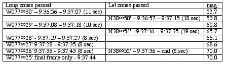
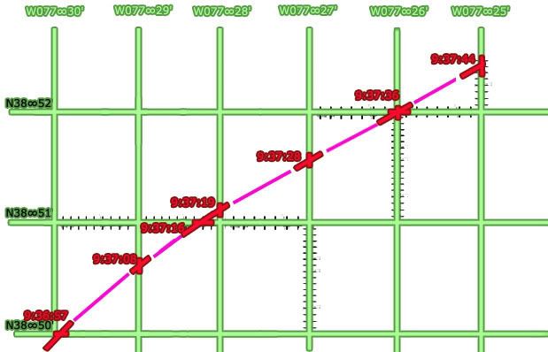
The number of seconds taken to pass a certain way is marked off on that axis, true heading (mag angles minus ten degrees) are marked at each crossing (red), with the rest of flight filled in between (magenta). In retrospect my grid is slightly uneven, giving a mild wiggle to the flight path – but all proportions, times, and locations otherwise line up – as usual not exact but close enough to see a clear and logical pattern.
Which becomes interesting when it tries to line up with real-world grid lines, mapped here with the same curve from above matched with the official final trajectory and impact point.

A literal mapping would make no sense, putting the path consistently about 20 miles off to the west via the massive longitudinal offset previously calculated at about 22 minutes (about 1/3 of a degree) – but here I took the west-offset arbitrarily as a whole-minute difference of 21' to match closest lines in the area - W077∞30' mapped over W077°09', etc. Any possible north offset was ignored, with latitude lines placed the same (38∞52' mapped as 38°52').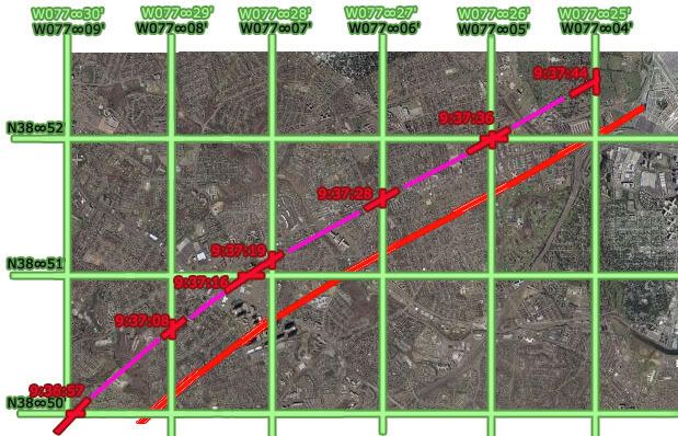
The flight paths don’t match up, evidencing a north deviation of approximately 20 seconds north of real. The west reading appears roughly on with the 21 minute offset, but on closer inspection syops a bit short. The exact end point is less clear; considering one second left from the csv's last frame 'till impact, about 3-4 seconds at current rate to reach Pentagon from 04 line, this puts the readings again around 20-25 geo seconds too far west.
Csv flight path and corresponding grid shifted to match official flight path:

The Offset is roughly square or perhaps proportionate to the rectangular parcels marked out here – about a third of a minute on each side. So the West offset is now set by me at about 21’20” West and 0’20” north.
Adam Larson / Caustic Logic
The Frustrating Fraud
September 7 2007
Again with the things that've been done before.
In trying to map out the final locations of the plane recorded in the csv file, I ran up against the problem of readings measured with degrees and minutes, but not seconds. This isn’t precise enough to see how the final plots compare to the official story; at 9:36:45 for example, it was somewhere in the zone marked by N38∞49',W077∞31', something like a square mile. While seconds are not recorded, minute rollovers and heading are, so I graphed out when it crossed what lines at what angle and went from there to use timeline seconds to help get a better idea of geographical seconds.
Lat-long minute lines crossed in the last minute of flight – just as the 330 loop was finishing and the plane straightened out on a 70 heading – 9:37:45-9:37:44:
The number of seconds taken to pass a certain way is marked off on that axis, true heading (mag angles minus ten degrees) are marked at each crossing (red), with the rest of flight filled in between (magenta). In retrospect my grid is slightly uneven, giving a mild wiggle to the flight path – but all proportions, times, and locations otherwise line up – as usual not exact but close enough to see a clear and logical pattern.
Which becomes interesting when it tries to line up with real-world grid lines, mapped here with the same curve from above matched with the official final trajectory and impact point.
A literal mapping would make no sense, putting the path consistently about 20 miles off to the west via the massive longitudinal offset previously calculated at about 22 minutes (about 1/3 of a degree) – but here I took the west-offset arbitrarily as a whole-minute difference of 21' to match closest lines in the area - W077∞30' mapped over W077°09', etc. Any possible north offset was ignored, with latitude lines placed the same (38∞52' mapped as 38°52').
The flight paths don’t match up, evidencing a north deviation of approximately 20 seconds north of real. The west reading appears roughly on with the 21 minute offset, but on closer inspection syops a bit short. The exact end point is less clear; considering one second left from the csv's last frame 'till impact, about 3-4 seconds at current rate to reach Pentagon from 04 line, this puts the readings again around 20-25 geo seconds too far west.
Csv flight path and corresponding grid shifted to match official flight path:
The Offset is roughly square or perhaps proportionate to the rectangular parcels marked out here – about a third of a minute on each side. So the West offset is now set by me at about 21’20” West and 0’20” north.
Sunday, August 26, 2007
NTSB ANIMATION INTERNAL GEOGRAPHY, PART 4: LATITUDE COLOR TRACK
NTSB ANIMATION INTERNAL GEOGRAPHY, PART 4: LATITUDE COLOR TRACK
Adam Larson / Caustic Logic
The Frustrating Fraud
rough draft, last updated 8/29 early am
The Color Track System
The tedium of mapping out the otherwise-ignored and probably irrelevant global grid beneath the plane in the NTSB animation is finally paying off, and looking at the east-west latitude lines passed or paralleled on the screen, I’ve made some interesting discoveries.
I have identified eleven latitude lines of note that frame the flight’s north-south dimensions and run along its east-west axis. I color-coded each line individually tracing it, continuously through its flight. each line is verified at multiple points as contiguous, parallel to its neighbors, and having a steady relation to the evolving flight path/ground track – in generally far more parallel than is warranted for real-world latitude lines but a general good fit for lines oriented to magnetic north.
1-blue – northernmost, never crossed
2-violet – next line south
3-purple – the most consistently paralleled line on the outbound flight.
4-magenta
5-red
6-orange
7-yellow – actually the first line crossed at the runway
8 –green
9 – aqua – the most consistently paralleled line on the outbound flight.
10 –sky blue – southernmost line actually crossed
11 – dark blue (intermittent, never crossed)
 Here are lines 4-11 as seen at 9:07:39, headed more or less east (84 magnetic at this spot). Note that here on the south side, the exact lines at or near to north half flight path are not entirely clear. Lines 2 and three are there as well but unmarked due to lack of clarity. Reading the south path from north yields similar results, but there are better views that illustrate the color continuity.
To show how I tracked them, I’m imbedding a rudimentary “animation” of several dozen frames made in Photoshop of stills from the animation with the colored lines traced on. This is version 2, with another version or two to come before I call it good enough. The music is my own, from '99.
Initially what I saw was something like this over the full flight path:
 (new window for full size)
I think it's a bit wrong, arrived at by misreading the cross-points at the south turn slightly, and by copying the exact bend I had mapped out for line 3 (see below) for each line. But while this grid came close to explaining what the animation shows, there are some serious perspective issues at work, and the obvious point that there's no such bend visible in the onscreen "latitude lines." I'd guess a subtle curve would actually explain it better, but also started tinkering with some straight-line solutions. Straight lines visibly and logically make more sense, and are more likely correct. But compared to what's seen in the video, this one at least is off on significantly on several points.

Examples:
Yellow Track – Line 7
 Just to start, I’ve marked the ends of the color-coded latitude lines as the flight path turns sharply south around 8:55 am, just after the takeover. Eight of the 11 lines (lines 2-9) are crossed in this ominous maneuver roughly as mapped out below. Note where line 7 (yellow) crosses at the west end of the path, during the turn at about 8:58. Keep this location in mind as we shift attention to the other end(s) of the flight path.
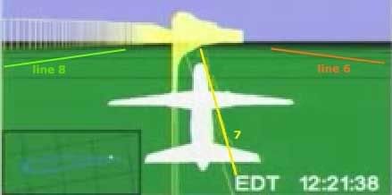 The yellow line continues down the middle of the space between the outbound and return flights. At the other end of the bent, elongated horseshoe flight path, the line still runs and is visible in both directions. Just after takeoff - 8:22 am the plane is paralleling line 7, line 8 visible to the left just north of the return flight ground track (and line 9 – aqua – is also there but not clear enough to mark), and 6 to the right. Perspective here is fierce, and the picture gets clearer as the plane gets higher.
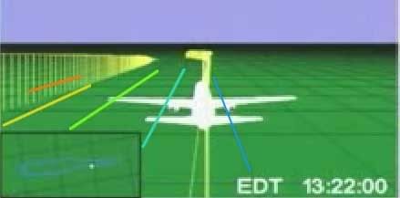 Here it is an hour later as it neared the same point; this is the bottleneck of the flight, where we can see an easier point for referencing the other side and establishing continuity. There are about 2.5 parcels marked out by three lines running between the two paths, and the angle is clear to see. If these are east-west lines, why is the plane angling to the right in both directions when it was supposed to be southwest then northeast, and should slant to the left?
Purple Track - Line 3
In the video above, watch from frames 12:34:48 to the south turn.The red line down the center is number 5, the magenta number 4, and purple is number 3, which is interesting to follow. It first passes under flight path at about 8:36, during northward turn. Line 2 (violet) is also barely passed a minute or so later and then paralleled, though the plane remains south of line 1 (blue) the whole time. Follow the track ahead a few frames, and notice that as the plane corrects back to the south it passes near line 3, but the ground track never again touches or crosses it until the south turn at the end there.
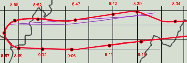 In order for this single line to both cross during the north sweep and again as it turns south, at least as I’ve plotted those points, it could not be east-west in relation to the official flight path. The most logical conclusion is that it has a slant, shown here as the straight purple line. However, the ground track does not cross over or touch this line again in the animation between these two points, as it would at 8:47 if a straight slant. In fact it almost seems to bow around that point from slanted to true east-west. This may sound strange, but compare the straight slant to the bowed line with what’s seen in the animation and tell me if this doesn’t fit better. Or is the roughness of my graphics, like the placement of 8:47 plot, enough to throw this off and insinuate a bend?
---
Aqua/Sky Blue Track – lines 9 and 10
Line 9, coded aqua, is the one most closely paralleled on the return flight. The third southernmost line, it’s first intersected by the ground track around9:01. Line 10 (sky blue) is to its right (south), of course also closely paralelled. Together they frame its return flight.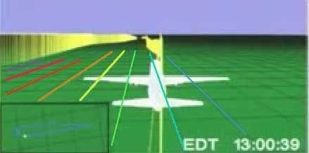 9:00:39 - just after the south turn but straightening out to head east - lines 3-10 shown here – line 9 (aqua) is just south of the ground track here, but the plane soon crosses so it’s to the north, and then evens out and parallels right over for a while. The cross-point for line 9 is further out than it seems, and is clearly not parallel here (as I said in the video - above - will be fixed in version 3).
 Despite 20 minutes travel and a recorded northward turn, line 9 is still running parallel and near the ground track, which is only slowly approaching line 10 (sky blue). Now – heading slightly northeast (mag heading 90, 80 real) – should it be trending slightly south between “latitude lines?”
And finally tracing the lines through the final approach loop, we see that aqua line 9 is the one that crosses the Pentagon overlay map. I'm not able to match this with my path here without a final curve, but again, the red path is less than perfect (I had similar troubles matching up line 7 after takeoff). Either way, this rough intersection gives us an end point to draw a more precise track of lines 9 and 10.
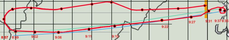 Looking for traight line solution, none seemed to work for all points. But I was able to soften the curve greatly and found the best fit, much better than my bent model above. On the whole it’s effectively straight, so I’m thinking now the lines are most likely straight but clearly slanted from reality. I keep seeing a curve if not a bend, but it's subtler than I thought,and possibly an illusion from my flight path graphics' imprecision (I have below corrected at least one small spot, placing 9:15 a few minutes further north to match the csv, which helps the straight lines fit). This graphic shows a curved version that works quite well along with the closest fit straight solution (lines slanted at about 83 degrees, seven degrees counter-clockwise from reality). Note the marginal difference.
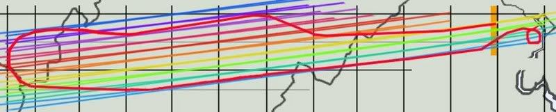
---
To come: the final map of all lines that works best at all points then I am done with this stupid subject.
Then final grid analysis and overlay map rotation issues relative to that and then I'm really done.
Adam Larson / Caustic Logic
The Frustrating Fraud
rough draft, last updated 8/29 early am
The Color Track System
The tedium of mapping out the otherwise-ignored and probably irrelevant global grid beneath the plane in the NTSB animation is finally paying off, and looking at the east-west latitude lines passed or paralleled on the screen, I’ve made some interesting discoveries.
I have identified eleven latitude lines of note that frame the flight’s north-south dimensions and run along its east-west axis. I color-coded each line individually tracing it, continuously through its flight. each line is verified at multiple points as contiguous, parallel to its neighbors, and having a steady relation to the evolving flight path/ground track – in generally far more parallel than is warranted for real-world latitude lines but a general good fit for lines oriented to magnetic north.
1-blue – northernmost, never crossed
2-violet – next line south
3-purple – the most consistently paralleled line on the outbound flight.
4-magenta
5-red
6-orange
7-yellow – actually the first line crossed at the runway
8 –green
9 – aqua – the most consistently paralleled line on the outbound flight.
10 –sky blue – southernmost line actually crossed
11 – dark blue (intermittent, never crossed)
Here are lines 4-11 as seen at 9:07:39, headed more or less east (84 magnetic at this spot). Note that here on the south side, the exact lines at or near to north half flight path are not entirely clear. Lines 2 and three are there as well but unmarked due to lack of clarity. Reading the south path from north yields similar results, but there are better views that illustrate the color continuity. To show how I tracked them, I’m imbedding a rudimentary “animation” of several dozen frames made in Photoshop of stills from the animation with the colored lines traced on. This is version 2, with another version or two to come before I call it good enough. The music is my own, from '99.
Initially what I saw was something like this over the full flight path:
(new window for full size)I think it's a bit wrong, arrived at by misreading the cross-points at the south turn slightly, and by copying the exact bend I had mapped out for line 3 (see below) for each line. But while this grid came close to explaining what the animation shows, there are some serious perspective issues at work, and the obvious point that there's no such bend visible in the onscreen "latitude lines." I'd guess a subtle curve would actually explain it better, but also started tinkering with some straight-line solutions. Straight lines visibly and logically make more sense, and are more likely correct. But compared to what's seen in the video, this one at least is off on significantly on several points.
Examples:
Yellow Track – Line 7
Just to start, I’ve marked the ends of the color-coded latitude lines as the flight path turns sharply south around 8:55 am, just after the takeover. Eight of the 11 lines (lines 2-9) are crossed in this ominous maneuver roughly as mapped out below. Note where line 7 (yellow) crosses at the west end of the path, during the turn at about 8:58. Keep this location in mind as we shift attention to the other end(s) of the flight path. The yellow line continues down the middle of the space between the outbound and return flights. At the other end of the bent, elongated horseshoe flight path, the line still runs and is visible in both directions. Just after takeoff - 8:22 am the plane is paralleling line 7, line 8 visible to the left just north of the return flight ground track (and line 9 – aqua – is also there but not clear enough to mark), and 6 to the right. Perspective here is fierce, and the picture gets clearer as the plane gets higher. Here it is an hour later as it neared the same point; this is the bottleneck of the flight, where we can see an easier point for referencing the other side and establishing continuity. There are about 2.5 parcels marked out by three lines running between the two paths, and the angle is clear to see. If these are east-west lines, why is the plane angling to the right in both directions when it was supposed to be southwest then northeast, and should slant to the left? Purple Track - Line 3
In the video above, watch from frames 12:34:48 to the south turn.The red line down the center is number 5, the magenta number 4, and purple is number 3, which is interesting to follow. It first passes under flight path at about 8:36, during northward turn. Line 2 (violet) is also barely passed a minute or so later and then paralleled, though the plane remains south of line 1 (blue) the whole time. Follow the track ahead a few frames, and notice that as the plane corrects back to the south it passes near line 3, but the ground track never again touches or crosses it until the south turn at the end there.
In order for this single line to both cross during the north sweep and again as it turns south, at least as I’ve plotted those points, it could not be east-west in relation to the official flight path. The most logical conclusion is that it has a slant, shown here as the straight purple line. However, the ground track does not cross over or touch this line again in the animation between these two points, as it would at 8:47 if a straight slant. In fact it almost seems to bow around that point from slanted to true east-west. This may sound strange, but compare the straight slant to the bowed line with what’s seen in the animation and tell me if this doesn’t fit better. Or is the roughness of my graphics, like the placement of 8:47 plot, enough to throw this off and insinuate a bend? ---
Aqua/Sky Blue Track – lines 9 and 10
Line 9, coded aqua, is the one most closely paralleled on the return flight. The third southernmost line, it’s first intersected by the ground track around9:01. Line 10 (sky blue) is to its right (south), of course also closely paralelled. Together they frame its return flight.
9:00:39 - just after the south turn but straightening out to head east - lines 3-10 shown here – line 9 (aqua) is just south of the ground track here, but the plane soon crosses so it’s to the north, and then evens out and parallels right over for a while. The cross-point for line 9 is further out than it seems, and is clearly not parallel here (as I said in the video - above - will be fixed in version 3). Despite 20 minutes travel and a recorded northward turn, line 9 is still running parallel and near the ground track, which is only slowly approaching line 10 (sky blue). Now – heading slightly northeast (mag heading 90, 80 real) – should it be trending slightly south between “latitude lines?” And finally tracing the lines through the final approach loop, we see that aqua line 9 is the one that crosses the Pentagon overlay map. I'm not able to match this with my path here without a final curve, but again, the red path is less than perfect (I had similar troubles matching up line 7 after takeoff). Either way, this rough intersection gives us an end point to draw a more precise track of lines 9 and 10.
Looking for traight line solution, none seemed to work for all points. But I was able to soften the curve greatly and found the best fit, much better than my bent model above. On the whole it’s effectively straight, so I’m thinking now the lines are most likely straight but clearly slanted from reality. I keep seeing a curve if not a bend, but it's subtler than I thought,and possibly an illusion from my flight path graphics' imprecision (I have below corrected at least one small spot, placing 9:15 a few minutes further north to match the csv, which helps the straight lines fit). This graphic shows a curved version that works quite well along with the closest fit straight solution (lines slanted at about 83 degrees, seven degrees counter-clockwise from reality). Note the marginal difference. ---
To come: the final map of all lines that works best at all points then I am done with this stupid subject.
Then final grid analysis and overlay map rotation issues relative to that and then I'm really done.
Friday, August 24, 2007
CSV / ANIMATION / OFFICIAL FLIGHT PATH AGREEMENT
CSV / ANIMATION / OFFICIAL FLIGHT PATH AGREEMENT
Adam Larson / Caustic Logic
The Frustrating Fraud
August 24 2007
A small post to tide my swarming readers over until I finish my animation geography analysis; I recently found, for what it’s worth, both the animation and the csv file seem to agree with the official story [ed - on this issue - the general flight path]. This is nothing new, of course, but barring minor variations of whatever significance, and looking at the 320-mile long swathe of land flown over by Flight 77, it’s all a remarkable fit.
Earthtools tells me the furthest point west in the official path is about 82° 44' 56” W, while the csv file records 83°06’ as the largest west number. These two numbers are off by about 21-22 minutes (no seconds recorded in the csv so exact margin cannot be determined), or about the margin they’re off by for the whole flight (explained here). So the official story and the csv file (corrected) match on lat/long readings at the furthest point west, and they also match at Dulles and the Pentagon; by being about 22 degrees apart across the board, they verify the board. As for the animation, I ignored its apparent lat/long grid appearing consistently off, and just used it to place the plane roughly at given times on its flight path (for example, just before a left turn at 8:39).
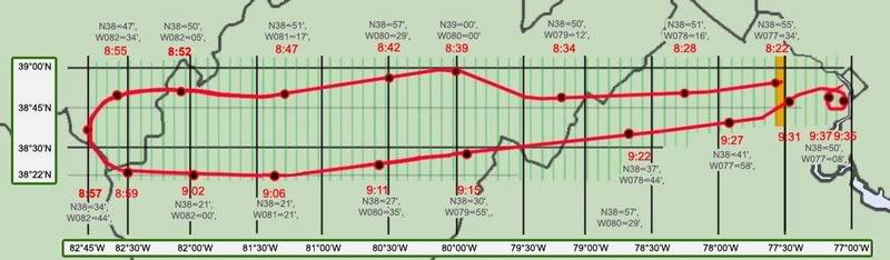
I made this map by stretching the 9/11 Commission’s flight path map w/state borders to fit a larger map of those borders. I then recreated the path (a bit rough in the curves) for greater clarity. I set the lat/long grid lines beneath it with Earthtools. Along the flight path, I marked 19 timed locations at key times. These were first plotted visually according to the animation, and then fine-tuned with the csv file (west corrected).
Note the remarkable, if not exact, correlation of all these data sets. The plots are off by a few minutes here and there, but on the scale of this 320-mile long swathe it all generally lines up. This is not surprising of course, as the Commission’s map and the official story in general have always relied on the flight path first downloaded we’re told within days of the attack. Just take this as another verification that the official data all lines up on the big picture flight path issue, and another excuse for me to publish a cool new graphic.
Adam Larson / Caustic Logic
The Frustrating Fraud
August 24 2007
A small post to tide my swarming readers over until I finish my animation geography analysis; I recently found, for what it’s worth, both the animation and the csv file seem to agree with the official story [ed - on this issue - the general flight path]. This is nothing new, of course, but barring minor variations of whatever significance, and looking at the 320-mile long swathe of land flown over by Flight 77, it’s all a remarkable fit.
Earthtools tells me the furthest point west in the official path is about 82° 44' 56” W, while the csv file records 83°06’ as the largest west number. These two numbers are off by about 21-22 minutes (no seconds recorded in the csv so exact margin cannot be determined), or about the margin they’re off by for the whole flight (explained here). So the official story and the csv file (corrected) match on lat/long readings at the furthest point west, and they also match at Dulles and the Pentagon; by being about 22 degrees apart across the board, they verify the board. As for the animation, I ignored its apparent lat/long grid appearing consistently off, and just used it to place the plane roughly at given times on its flight path (for example, just before a left turn at 8:39).
I made this map by stretching the 9/11 Commission’s flight path map w/state borders to fit a larger map of those borders. I then recreated the path (a bit rough in the curves) for greater clarity. I set the lat/long grid lines beneath it with Earthtools. Along the flight path, I marked 19 timed locations at key times. These were first plotted visually according to the animation, and then fine-tuned with the csv file (west corrected).
Note the remarkable, if not exact, correlation of all these data sets. The plots are off by a few minutes here and there, but on the scale of this 320-mile long swathe it all generally lines up. This is not surprising of course, as the Commission’s map and the official story in general have always relied on the flight path first downloaded we’re told within days of the attack. Just take this as another verification that the official data all lines up on the big picture flight path issue, and another excuse for me to publish a cool new graphic.
Tuesday, August 21, 2007
NTSB ANIMATION INTERNAL GEOGRAPHY, PART 3: GRID CLUES: ORIENTATION AND PROPORTIONS
NTSB ANIMATION INTERNAL GEOGRAPHY, PART 3: GRID CLUES: ORIENTATION AND PROPORTIONS
Adam Larson / Caustic Logic
The Frustrating Fraud
August 21 2007
last updated 8/22, 1:00 pm
I had promised a piece on the grid's "latitudelines," but that one will take a little more work and could use some foreshadowing, and so here are four clues to what I'm starting to decide on...
Regarding the background grid of the NTSB's Flight 77 animation, the questions of rectangular parcel proportions and overall northern orientation are closely related. Wondering how it’s oriented may seem silly; one would presume the Safety Board’s experts, if not the FDR itself, would correct what the compass knows and show the plane on a true east-west north-south grid, with the magnetic headings showing up off from these (to almost exactly ten degrees) as they would have in real life. This does not seem to be the case.
Four clues:
1) Mini-master map:
 the full flight path is reproduced in the small window at the lower left of the animation screen and offers clues to both proportions and slope. Here is a screen cap with enhanced lines vs. official flight and real lat-long lines crossed. The animation seems to stretch the flight path over almost three squares. Undertow pointed this out to me, though I’d noticed it before, and it’s definitely a possible clue. If these mark some amalgamation of the onscreen rectangles, they should have the same proportions as those smaller parcels. That is, if a block of say 60 minutes by 60 minutes is square, a one-by-one minute unit should also be square. There is also, obviously, an angular slope evident between the two; the lower portion, again, shows the true east-west orientation of the official path, while the grid lines around the animation’s mini-map are rotated about 8-9 degrees counter-clockwise, just about consistent with magnetic north (declination 10.08 degrees).
2) lines at 270°
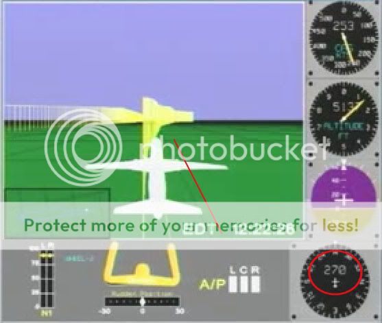 At 8:22 am the plane has a heading (nosecone orientation) of 270 degrees - due west from magnetic north, just southwest of west in true terms. It's just about parallel with the nearest latitude-looking line, and perpedicular to the longitude lines ahead. As for parcel proportions, they look fairly square here. However, perspective at this fairly low altitude of 5137 feet is fierce and makes it unclear and inconclusive.
3) Lines at 180°
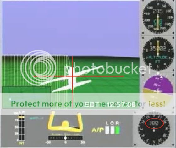 As the plane nears the mid-point of its southward turn, at 8:57, the longitude line under it shows exactly vertical, and latitudes ahead of it exactly horizontal. The heading dia shows 180, or due south. This would make perfect sense if the grid were oriented to magnetic north. These rectangles also look remarkably square seen from an elevation of over 35,000 feet, as opposed to the roughly 5:7 proportions of latitude/longitude intersections there in the real world.
4) Lines at 70°
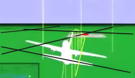 I wanted to analyze the final trajectory shown in the animation in relation to the global map, but found that harder than due west and south. To start with, here is a frame with grid lines, Pentagon location, and track (flight path along the ground) highlighted. The magnetic dial hovers right around 70° from north on this final track.
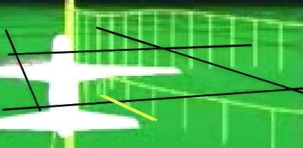
At right is another view from just before the grand loop show just where on that parcel’s west edge the ground track crosses. I figured If I marked this and de-skewed the parcel I could masure its angle of incidence.

To measure this angle for sure, I’d need to know the proportions of the rectangles, something made difficult by the foreshortened perspective. Again this looks fairly square to me, so just on a hunch I ignored real-world lines and tried de-skewing the grid there into a square. This is all a bit approximate, so don’t expect precision to more than a degree or two.
Interestingly enough, we get almost exactly 70 degrees, which is what the FDR says on that path (both in the CSV file and the animation’s heading dial). Subtracting 10 degrees for magnetic declination, we have the official trajectory of 60 that matches the physical damage.
On all four points above, the flight path reads correct in angles relative to its own internal geography, but not to real-world lines, in either placement or slope. From this, my best guess at the moment is that the animation program is pointing its longitude lines to magnetic north, and its latitudes perpendicular to that, throwing the whole grid off by a rotation of approximately ten degrees. And on top of that, it's generating a square grid map, unlike real-world lines, in which latitude lines are further apart than longitudes. This equilateral proportion indicates the flight path may've been rendered at some default equator on this globe rather than at the proper latitude. If the lines even represent latitudes and longitudes at all and not some other type of grid.
To see whether this is confirmed or denied by the latitude lines involved, I will be posting a detailed piece soon and even a short "video." In fact this is already up on Youtube and viewable at this link. Sorry for the low resolution and the choppiness of my frames. I hope it works - compare to the original animation if that helps.
Adam Larson / Caustic Logic
The Frustrating Fraud
August 21 2007
last updated 8/22, 1:00 pm
I had promised a piece on the grid's "latitudelines," but that one will take a little more work and could use some foreshadowing, and so here are four clues to what I'm starting to decide on...
Regarding the background grid of the NTSB's Flight 77 animation, the questions of rectangular parcel proportions and overall northern orientation are closely related. Wondering how it’s oriented may seem silly; one would presume the Safety Board’s experts, if not the FDR itself, would correct what the compass knows and show the plane on a true east-west north-south grid, with the magnetic headings showing up off from these (to almost exactly ten degrees) as they would have in real life. This does not seem to be the case.
Four clues:
1) Mini-master map:
the full flight path is reproduced in the small window at the lower left of the animation screen and offers clues to both proportions and slope. Here is a screen cap with enhanced lines vs. official flight and real lat-long lines crossed. The animation seems to stretch the flight path over almost three squares. Undertow pointed this out to me, though I’d noticed it before, and it’s definitely a possible clue. If these mark some amalgamation of the onscreen rectangles, they should have the same proportions as those smaller parcels. That is, if a block of say 60 minutes by 60 minutes is square, a one-by-one minute unit should also be square. There is also, obviously, an angular slope evident between the two; the lower portion, again, shows the true east-west orientation of the official path, while the grid lines around the animation’s mini-map are rotated about 8-9 degrees counter-clockwise, just about consistent with magnetic north (declination 10.08 degrees). 2) lines at 270°
At 8:22 am the plane has a heading (nosecone orientation) of 270 degrees - due west from magnetic north, just southwest of west in true terms. It's just about parallel with the nearest latitude-looking line, and perpedicular to the longitude lines ahead. As for parcel proportions, they look fairly square here. However, perspective at this fairly low altitude of 5137 feet is fierce and makes it unclear and inconclusive. 3) Lines at 180°
As the plane nears the mid-point of its southward turn, at 8:57, the longitude line under it shows exactly vertical, and latitudes ahead of it exactly horizontal. The heading dia shows 180, or due south. This would make perfect sense if the grid were oriented to magnetic north. These rectangles also look remarkably square seen from an elevation of over 35,000 feet, as opposed to the roughly 5:7 proportions of latitude/longitude intersections there in the real world. 4) Lines at 70°
I wanted to analyze the final trajectory shown in the animation in relation to the global map, but found that harder than due west and south. To start with, here is a frame with grid lines, Pentagon location, and track (flight path along the ground) highlighted. The magnetic dial hovers right around 70° from north on this final track. At right is another view from just before the grand loop show just where on that parcel’s west edge the ground track crosses. I figured If I marked this and de-skewed the parcel I could masure its angle of incidence.
To measure this angle for sure, I’d need to know the proportions of the rectangles, something made difficult by the foreshortened perspective. Again this looks fairly square to me, so just on a hunch I ignored real-world lines and tried de-skewing the grid there into a square. This is all a bit approximate, so don’t expect precision to more than a degree or two.
Interestingly enough, we get almost exactly 70 degrees, which is what the FDR says on that path (both in the CSV file and the animation’s heading dial). Subtracting 10 degrees for magnetic declination, we have the official trajectory of 60 that matches the physical damage.
On all four points above, the flight path reads correct in angles relative to its own internal geography, but not to real-world lines, in either placement or slope. From this, my best guess at the moment is that the animation program is pointing its longitude lines to magnetic north, and its latitudes perpendicular to that, throwing the whole grid off by a rotation of approximately ten degrees. And on top of that, it's generating a square grid map, unlike real-world lines, in which latitude lines are further apart than longitudes. This equilateral proportion indicates the flight path may've been rendered at some default equator on this globe rather than at the proper latitude. If the lines even represent latitudes and longitudes at all and not some other type of grid.
To see whether this is confirmed or denied by the latitude lines involved, I will be posting a detailed piece soon and even a short "video." In fact this is already up on Youtube and viewable at this link. Sorry for the low resolution and the choppiness of my frames. I hope it works - compare to the original animation if that helps.
Monday, August 13, 2007
NTSB ANIMATION INTERNAL GEOGRAPHY, PART 2
NTSB ANIMATION INTERNAL GEOGRAPHY, PART 2:
LONGITUDE LINES
Adam Larson / Caustic Logic
The Frustrating Fraud
July 12 2007
Updated Sept 3
As a primarily west-then-eastbound flight, 77 would have crossed more n-s running longitude lines than it would latitude lines. So in mapping what the NTSB animation shows in comparison to reality, let’s start with this more tedious operation with a larger room for error before the more delicate reading required for the latitude lines.
This map is based on the official path in the 9/11 Commission Report, with real-world latitude and longitude lines mapped behind it. I’ve marked longitude lines (vertical, running to the geographic north pole) at the degree and 30-minute marks, and the latitudes at intervals of 15 minutes, with the exception of the westernmost and southernmost lines, which are where they are.
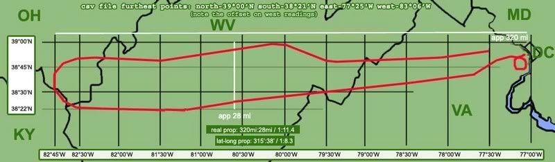 right-click, new window, for full-size
Full proportions of the flight:
Flight 77’s takeoff coordinates, which I’ve taken as the end of runway 30 at Dulles, are 38 degrees, 56 minutes, 40 seconds north of the equator (38° 56' 40" N) and 77 degrees, 30 minutes, 11 seconds west of Greenwich. (77° 30' 11" W).
furthest point west: 82° 44' 56" W (83°06 by the NTSB's csv file, which is 22 degrees off)
furthest point east - 77°03’30” (again, 77°25' by the csv)
Total distance traveled west from Dulles:
82° 44' 77° 30' = 5° 15'
5.25 degrees, about 295 miles, 315 minutes, 18,900 seconds.
Lateral return distance to the Pentagon: 320 miles from furthest point west, just under 5.75 degrees, 345 minutes, 20,700 seconds.
So one thing to note here is that the official story's east-west-locations match the plots recorded in the csv; that is, by being about 22 degrees apart across the board, they verify the board. Now that we’ve parceled up reality with a multiple corroborated map, let’s see what the animation shows for longitude lines crossed. If the rendering program were marking at degree lines (77, 78, 79...), we’d see only five of them crossed on the way out. If they were marked at the 30-minute points as I’ve done here, we’d see 11 of them, and 314 if split up at the minute level. If they were marked wherever else…
Looking at the animation, the first longitude line crossed comes soon after leaving the runway. This line passes off-screen at about 12:21:15, or 8:21 am, by the animation’s time code. The second line is crossed around 12:22:10, and so on every minute or so thereafter.
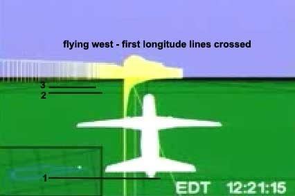 For example, line 23 is passed around 8:34:15, after which the animation shows the plane turning north, with line 24 and the next passing off-screen around 34:40, 35:15, 35:50, etc.
The last lines are hard to read, as the plane turns south to head back. The plane turns sharply to the left after 8:54, just after the hijacking commenced, making the ground track hard to follow. The final lines were crossed more slowly; line 61 would have been crossed around 8:54, and the final mark passed obliquely around 8:55:30, nearing but never crossing the next longitude marker as it turned to a south bearing of 180 at about 8:57, and kept turning to point east and return.
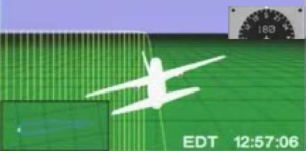 So I may be off by one or two lines, but this is a large enough sample that I’ll say close enough. Sixty-two perpendiculars passed means 63 marked longitude zones traversed on the initial westbound flight, and one would presume a few more on the return flight that overshot the origin by a 20 miles. On the map below, I marked 62 vertical lines, evenly spaced (to a pixel or two), and stretched it over the flight path from just after the origin point ay 77° 30'. It lines up roughly with an interval of five minutes real, there being an average of six divisions to each 30’ interval.
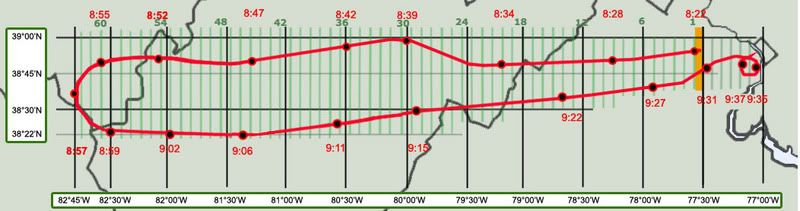 right-click, new window, for full-size
Mathematically, it also happens that 5 times 63 gives us 315, the number of minutes I figure were passed. So whether by design or not, the global map is marking intervals of about five minutes on its east-west axis. This would mean 12 markers per degree, which seems an odd but logical enough system. It does simplify the reading of it; no way would I have tried to count 314 passing blurry lines.
Or it could be a coincidence that my imprecise reading closely matches such a possible system. Either way, it carries over into the final stretch before impact. Presuming the same 62 lines crossed until the plane passed south of Dulles, It seems the return flight tops it by another six. The origin zone is entered at about 9:29:30 in the animation, the first line east of there crossed soon after, and then five more. The sixth line is the only one crossed twice; at 9:34 as it starts the 330 southward loop, and again as it straightens out from this and dives to its terminus, nearing but not passing the seventh longitude line east of Dulles. The proportions that described the westbound flight apply here as well, with the zone from 77:30-77:00 looking to be marked into about six parcels of five minutes each.
It’s possible that these lines do not in fact run due north, but are offset due to the grid being oriented to magnetic north. Trying to compare and calculate their verticality based on the visuals in the animation seems daunting. More precision is possible with the much fewer latitude lines. These seem to run near-parallel to most of the flight, giving us readable slants over certain distances. To determine both the possible slope of an offset grid, and to look at the proportions of the marked parcels, we’ll need to look at these presumably east-west lines, which it seems will require yet another separate post. This analysis will be far more interesting and its graphics more colorful; I’m seeing patterns that bring into question the global grid’s orientation and even internal consistency. Maybe. I’m still looking.
LONGITUDE LINES
Adam Larson / Caustic Logic
The Frustrating Fraud
July 12 2007
Updated Sept 3
As a primarily west-then-eastbound flight, 77 would have crossed more n-s running longitude lines than it would latitude lines. So in mapping what the NTSB animation shows in comparison to reality, let’s start with this more tedious operation with a larger room for error before the more delicate reading required for the latitude lines.
This map is based on the official path in the 9/11 Commission Report, with real-world latitude and longitude lines mapped behind it. I’ve marked longitude lines (vertical, running to the geographic north pole) at the degree and 30-minute marks, and the latitudes at intervals of 15 minutes, with the exception of the westernmost and southernmost lines, which are where they are.
right-click, new window, for full-sizeFull proportions of the flight:
Flight 77’s takeoff coordinates, which I’ve taken as the end of runway 30 at Dulles, are 38 degrees, 56 minutes, 40 seconds north of the equator (38° 56' 40" N) and 77 degrees, 30 minutes, 11 seconds west of Greenwich. (77° 30' 11" W).
furthest point west: 82° 44' 56" W (83°06 by the NTSB's csv file, which is 22 degrees off)
furthest point east - 77°03’30” (again, 77°25' by the csv)
Total distance traveled west from Dulles:
82° 44' 77° 30' = 5° 15'
5.25 degrees, about 295 miles, 315 minutes, 18,900 seconds.
Lateral return distance to the Pentagon: 320 miles from furthest point west, just under 5.75 degrees, 345 minutes, 20,700 seconds.
So one thing to note here is that the official story's east-west-locations match the plots recorded in the csv; that is, by being about 22 degrees apart across the board, they verify the board. Now that we’ve parceled up reality with a multiple corroborated map, let’s see what the animation shows for longitude lines crossed. If the rendering program were marking at degree lines (77, 78, 79...), we’d see only five of them crossed on the way out. If they were marked at the 30-minute points as I’ve done here, we’d see 11 of them, and 314 if split up at the minute level. If they were marked wherever else…
Looking at the animation, the first longitude line crossed comes soon after leaving the runway. This line passes off-screen at about 12:21:15, or 8:21 am, by the animation’s time code. The second line is crossed around 12:22:10, and so on every minute or so thereafter.
For example, line 23 is passed around 8:34:15, after which the animation shows the plane turning north, with line 24 and the next passing off-screen around 34:40, 35:15, 35:50, etc. The last lines are hard to read, as the plane turns south to head back. The plane turns sharply to the left after 8:54, just after the hijacking commenced, making the ground track hard to follow. The final lines were crossed more slowly; line 61 would have been crossed around 8:54, and the final mark passed obliquely around 8:55:30, nearing but never crossing the next longitude marker as it turned to a south bearing of 180 at about 8:57, and kept turning to point east and return.
So I may be off by one or two lines, but this is a large enough sample that I’ll say close enough. Sixty-two perpendiculars passed means 63 marked longitude zones traversed on the initial westbound flight, and one would presume a few more on the return flight that overshot the origin by a 20 miles. On the map below, I marked 62 vertical lines, evenly spaced (to a pixel or two), and stretched it over the flight path from just after the origin point ay 77° 30'. It lines up roughly with an interval of five minutes real, there being an average of six divisions to each 30’ interval. right-click, new window, for full-sizeMathematically, it also happens that 5 times 63 gives us 315, the number of minutes I figure were passed. So whether by design or not, the global map is marking intervals of about five minutes on its east-west axis. This would mean 12 markers per degree, which seems an odd but logical enough system. It does simplify the reading of it; no way would I have tried to count 314 passing blurry lines.
Or it could be a coincidence that my imprecise reading closely matches such a possible system. Either way, it carries over into the final stretch before impact. Presuming the same 62 lines crossed until the plane passed south of Dulles, It seems the return flight tops it by another six. The origin zone is entered at about 9:29:30 in the animation, the first line east of there crossed soon after, and then five more. The sixth line is the only one crossed twice; at 9:34 as it starts the 330 southward loop, and again as it straightens out from this and dives to its terminus, nearing but not passing the seventh longitude line east of Dulles. The proportions that described the westbound flight apply here as well, with the zone from 77:30-77:00 looking to be marked into about six parcels of five minutes each.
It’s possible that these lines do not in fact run due north, but are offset due to the grid being oriented to magnetic north. Trying to compare and calculate their verticality based on the visuals in the animation seems daunting. More precision is possible with the much fewer latitude lines. These seem to run near-parallel to most of the flight, giving us readable slants over certain distances. To determine both the possible slope of an offset grid, and to look at the proportions of the marked parcels, we’ll need to look at these presumably east-west lines, which it seems will require yet another separate post. This analysis will be far more interesting and its graphics more colorful; I’m seeing patterns that bring into question the global grid’s orientation and even internal consistency. Maybe. I’m still looking.
Subscribe to:
Posts (Atom)


