Showing posts with label FAA. Show all posts

Saturday, September 13, 2008

FAA? WTF?

FAA'S NoC ANIMATION
first posting Sept 13 2008, 12 am
Last update 10/8 2am


So, John Farmer is, I guess, back from Arlington and has received reams of new data, this time from the FAA. He alerted Arabesque and I via e-mail.

The FAA has sent me via certified mail all of the records I requested in my Court action. It is going to take the entire weekend to go through it all, but it looks like the ATC audio and radar records for 1332 – 1344 for Washington ARTCC, Dulles, Reagan, Andrews and Baltimore.

If this turns out to be everything I think it is, then CIT is going to be squirming a little more.


I get a lot of these from him and don't even usually keep up. But the second e-mail here, about the included animation, made me sit up and take notice.

I attempted to send you guys the whole video, but it was too big for some mailboxes. You are the first to see this (I hope) and you just know CIT and Rob are gonna love it!

http://www.youtube.com/watch?v=DQsyt_7c1H8


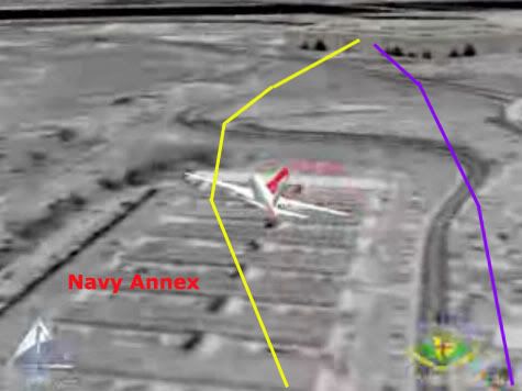
It shows, more or less, CIT's concocted path over the Navy Annex, with a hard hard right bank/turn and a passage north of the citgo, followed by low level impact (higher only to allow the right wing). I have just been in the middle of laying out the overabundance of North-path clues (there should be roughly nil), including the NTSB's earlier animation to similar effect, so this was doubly ironic as it hit me. This is so insane, the easiest explanation I can think of is... Farmer's pulling my leg?

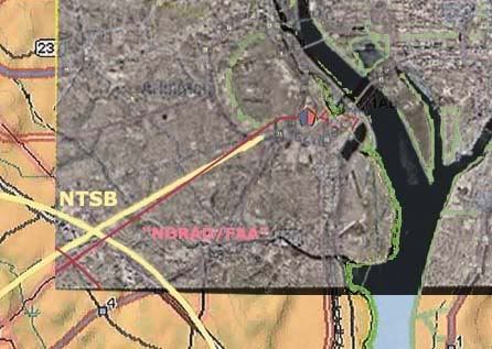
Two stills, with real and CIT paths (quite app) in the usual colors overlaid. These are from the Youtube version, but Farmer made a higher resolution version available for download and viewing.
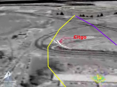

---first thoughts, unedited
Any thoughts, people? All I can think of is what - the - fuck?

Or, wait... mmmaybe FAA based it on radar and/or FDR up to the end of that data (the loop and all looks fine on first glance) and then stupidly tried to fuse in the NTSB's apparent final moments, hoping they had some reason for putting it on that path for the seconds they were missing (I'd guess 6-10?) ... Just mysteries. This is going to turn out interestingly.
---

Further Developments
Discussion on this took off all over with the expected rapidity, but a more dynamic embrace than some expected.
CIT Forum discussion
Craig and Aldo, who seethe with venom against Farmer, and aren't 'taking the bait' as it were. They speak of "chess moves" and such... Very sophisticated over there, their apprehension and ruminations! On the other hand, many like Rob Balsamo at the PfffT forum were giggling with excitement, while CIT strongly advised caution, leading to a curious argument about which dishonest track to take. CIT messenger Domenick DiMaggio (aka Terrocell, TC329) also started a JREF discussion thread about it, stating at one point:

they faked it and now they're releasing fake evidence to corroborate cit's evidence and yet still try to prove an impact. and as soon as you guys put the cats down and erase lloyd from the history books they can get away with their evil plans.


Whatwhatwhat? Nonetheless, this is where things took off with both confusion and learning. First, beyond disseminating it, the FAA seem to have no role in this short video. JREF member Gumboot first questioned their authenticity and/or their relevance, but over the first couple pages identified the logos onscreen (www.stk.com and HQ NORAD/USSPACE/AN), and found STK was the Satellite Tool Kit Radar module, marketed by Analytical Graphics, Inc. (AGI), a company that makes software for "national security and space professionals for integrated analysis of land, sea, air, and space assets." He noted "the big golf ball things" seemed to be FAA Long Range Radar sites, and decided this may well be "a radar-based map for NORAD purposes," possibly "to determine which radar sites AA77 passed through, so that 84th RADES knew which data to collect for their analysis." Definitely getting somewhere.

Radar based... north path... I would have figure it out eventually, but Celestrin beat me to it. No wonder CIT were apprehensive - they knew about the false return placed for whatever reason, just north of the Citgo, and I had to point out that it wasn't their north path plane, at least 1,000 feet to low for radar to see. Celestrin made the connect:

RADES data has been available for months and it shows the exact same North of Cthulhu poperties as this animation. [...] Why is it such a wonder that an animation, which most likely uses the same data, would also show the plane further north?


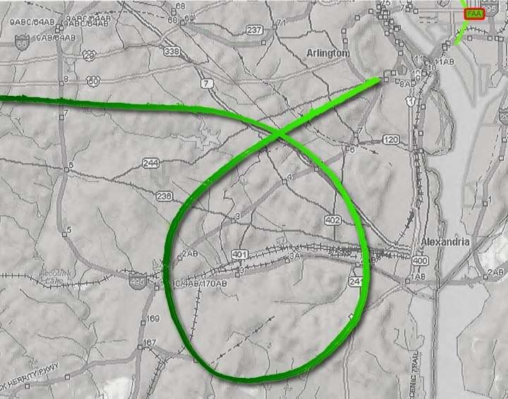
I looked at it a bit the other night and did some graphic comparisons just to see what patterns popped out. I took the peach map from the NTSB's Flight Path Study and set the final map of the animation over it [below]. Note the apparent offset in rotation and location of the loop cross point. I'm not actually sure if the whole path is rotated, or this is just a local distortion from roughness. It is rough and unrealistic in its movements.Farmer instantly pointed out "Look at the loop you idiots, it is a square with rounded corners!" I noticed this too, as did Celestrin. The "squarish" appearance of the turn manuever also suggests that the data, which was used in the animation, wasn't continous." Given 12-second intervals between returns is "too fine for the animation," he wondered "what if one takes the RADES data 1 minute apart," or every fifth radar return, and got this.

When I marked the spots where straight lines start curving, and overlaid it with the 84 RADES returns for the loop, it looks more like this was based on taking every other 84 RADES return (pink dots) as anchor points, and replaced the intervening ones with straight lines or full curves, depending.

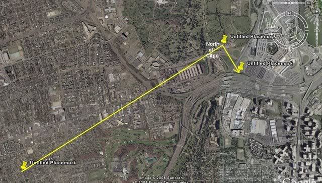

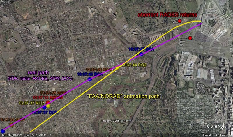
This in turn may be a clue to the north path’s appearance. Consider this pattern in light of these final three points of RADES data (the points stupidly connected above]. There may be a different dynamic at play here, but it seems similar in pattern – draw a straight line to, or near, the north point, and then a sharp curve to try and meet, or orbit, the next aberrant return just south of impact. Considering there may be a rotation of the path relative to the map, or vice-versa, and perhaps a slight spatial offset, the actual mapped curve may not be where it looks to be onscreen. Interestingly, when I rotate the line to fit the real path, the turn is about seven degrees, or the amount the NTSB's final map was rotated from its own lat-long grid. [Propos to Farmer for the background image establishing the real path beyond a reasonable doubt]. This is not my final answer, but I'm pretty sure it's close to correct, or on the right track at least.
---
More on the source
Pilots for 911 Truth forum member "Paranoia" looked at AGI's STK.com website and found some interesting information verifying Gumboot's ID. [link]. Of interest is a winter 2002 presentation by AGI President and CEO Paul Graziani, regarding their 9/11 animations. The accompanying powerpoint presentation confirms he's discussing this very simulation - it's pictured on page 5. In his delivered remarks [PDF link ], Graziani explained to assembled conventioneers how "actual FAA radar data was used to accurately recreate the events and model the flight paths of hijacked airlines as well as the responding military aircraft." Actual data, it would seem so. Accurate, only sorta... Of interest is the line "complex problems that once took weeks or months to complete, now take only seconds or minutes when employing software capabilities." Maybe they should have at least spent hours on this one.

Additional update: Just to clarify, this is a NORAD product, not FAA. This powerpoint presentation, from a June 2002 STK users conference, explains the project a little. It covered all four flights, plus responding fighters, all from FAA-supplied radar data.
---
The Video: I refined slightly the final returns angle, and put it together in video form, viewable with notes here.

Friday, June 6, 2008

RADAR = VISUAL = SOUTHWEST

RADAR = VISUAL = SOUTHWEST
Adam Larson / Caustic Logic
The Frustrating Fraud
June 6 2008


I could have posted this sooner, but it deserved some careful prep, and I’ve enjoyed CIT’s maneuvers in the interim. Sorry fellas – I did set it like an ambush, but didn’t expect it would actually work so well and so quick.

Recently I was able to contact FAA’s Colin Scoggins about his 9/11 report of a plane seen (I presumed) on radar southeast and/or southwest of the White House just prior to the attack. I was thrown for a loop when Scoggins told me it was a visual sighting from FAA HQ in the Capitol, and it seemed he was saying it was therefore NOT a radar report.

That wasn’t even my original question, but I poo-pooed this notion, given the great distance to see it. I did do up some scale experiments that indicated “they certainly would be able to visually pick it out" - barely, as a speck - "if they were first tipped off by, say, a radar report of a plane five miles southeast, er, southwest. But to notice it with no prompting makes little sense to me.”

In the comments at the above link, Craig Ranke of CIT showed his enthusiasm for this revelation and his own idea for the prompting in question:

“So Scoggins is 99% sure it was a visual from FAA HQ in downtown DC! Wow. Great work! Clearly that destroys the NTSB and supports EoP.
[…]
It wouldn't take a "hawkeye" on the DC flight path if they saw it pass their building over DC and kept following it and this does not make any sense AT ALL with the NTSB or alleged radar data!
[…]
>>>>You'd guess they were prompted by the over DC path to keep following it then?
If there is any truth at all to the this visual reference then it is the only explanation. Naturally any plane at all in P56 airspace would alert attention.”

[how about the outbound C-130 over the mall’s south edge? Any witnesses outside the plane?]

Ranke even started a thread at their forum, the last before the valuable threads posted later on “Tramsoccalpra” and “Hydrociault” that were REMOVED! (Censor Nazis ;))
DC flight path - East of Potomac evidence, further confirmed by ATC Colin Scoggins
, about how “CIT obsessed Adam Larson did a little investigating of his own and ended up CONFIRMING our claims!” He presented a fuller argument that does make sense given the state of the evidence yesterday, used my graphics, and even linked to the original as a valuable piece of research, if riddled with obfuscation and whatnot. Amazing. Cue the sparkly CIT lyte trip-hop music, this goes in the revised how they forgot to scratch Lloyd's hood and other addenda video...

As far as Ranke’s interpretation that a visual encounter supports the DC flight path, this does make some sense, depending on how much evidence there really is for it being over DC before this (hint – it’s a CIT claim). For CIT it’s a no-brainer since they already believe it was over DC and THIS is what prompted them to follow or project it south, southwest, and so on. But here’s a different, more informed insight, from another Scoggins e-mail just as Craig started posting stuff:

"This [is] taken from the USA Article I mentioned. This is the TELCON I beleive I was on. I am 99% sure. The call came from FAA HQ, and they were on the West side of the FAA HQ building, and Dave Canoles must have been on the North side, so Dave's office was a corner office or it was real close to the corner. "

Cue the record-scratch sound. Indeed. I had heard this article mentioned but hadn't read it, and apparently neither had Ranke. The whole article, from just after 9/11, is still available here. These are the relevant excerpts:

At FAA headquarters, less than a half-mile from the White House and Capitol, Dave Canoles paces before a speakerphone. The head of air traffic investigations, Canoles has set up phone connections with air traffic facilities. […] Now, about 9:35 a.m., he and others on the conference call listen as an official watching a radarscope tracks the progress of the jet heading for Washington

So my either-or impression was a false one based in my ignorance of this piece. Canoles is probably the muted voice we can hear behind Scoggins in the NORAD tapes, and he was first tipped off by another person elsewhere watching the radar track. This makes perfect sense, and then the visual part comes in, prompted by radar. Is there a clue in this to what the returns said?

“Canoles sends an investigator who works for him to an adjoining office with a view to the west. "See if you can spot it," he tells him.
"Six miles from the White House," a voice on the phone says.”
Canoles glances outside, through a window facing north. He wonders if he and his co-workers are in danger. At 500 mph, the jet is traveling a mile every seven seconds.
"Five miles from the White House."
No way the FAA is a target, Canoles thinks. It can't be.
"Four miles from the White House."
They'd never choose to hit us. No way.
"The aircraft is circling. It's turning away from the White House."
Where? Where's it going?
Then: "It's gone."
In the adjoining office, the investigator spots smoke to the west of the city. The jet has hit the Pentagon. The time: 9:38 a.m.”


Scoggins feels this account “flat out tells me that it is visual,” but I don’t really see it. There is talk of windows and attempts to see, which is a hint it might have gone there, but the only thing that’s clearly mentioned actually being seen is the smoke afterwards. Now since the investigator is in an adjoining room a phone bridge seems unnecessary, but it is possible he’s the one on the phone giving the updates based on what he’s seeing out the window. And it’s at least as possible, not knowing more, that these are from the same radar operator that got them started.

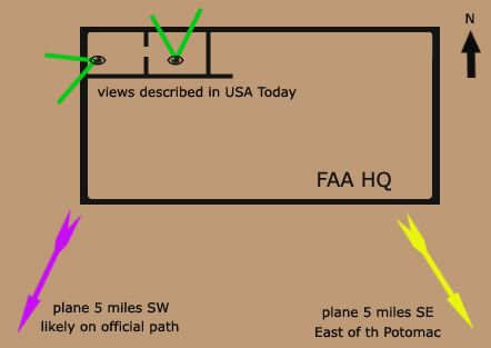
It’s not clear from this alone if there was ever a visual sighting of the plane, but Scoggins also heard what Canoles actually said, in the telcon we only hear murmurs of, and he is left 99% certain there was such a contact. I’m inclined at the moment to believe him. So treating this as an eyewitness case, let’s first note that the USA Today piece mentions a view to the north, meaning Canoles’ office was on the building’s north side – he had an investigator go into an adjoining, but different office, with a view to the west – a corner office.
It’s not clear if any sighting would be before the plane turned fully southward from its original path or after the loop and up to the final approach. The witness would not be able to see the farthest reaches of the loop (darker green, below) between these points at all without binoculars. He may well have had binoculars though, come to think of it. He could then have seen perhaps the entire loop, or any portion of it, all from that office with a view to the west.
Now, how can this visual sighting “further validate the east side evidence” if it’s taking place from a west-facing office, prompted by a radar report of a plane in that direction? Originally I offered the quite reasonable and well-supported guess that the southeast report was simple error in reporting a radar track. Then it seemed there was a visual contact instead of radar, which complicated things. Then I learned that this observance was spurred by radar and confirmed southwest, and while we still aren’t sure where the momentary inversion of east and west came in, it is looking pretty much out the window as evidence.

Wednesday, June 4, 2008

A VISUAL ENCOUNTER?

A VISUAL ENCOUNTER?
Adam Larson / Caustic Logic
The Frustrating Fraud
June 4 2008 2am


Colin Scoggins was the manager of FAA’s Boston Center as the attacks of 9/11 unfolded around him nearly seven years ago. He played an unexpectedly crucial role relaying information between the FAA, NEADS and others, as one can hear listening to the NORAD tapes released in 2004. Perhaps most famously he was the one who passed on the much-speculated on and unfortunate report at 9:21 am that Flight 11 was still airborne. I’ve been sent a copy of an off-line, detailed account Scoggins wrote, and was even able to make e-mail contact recently with Scoggins himself.

While I’m still trying to get his take on my own Flight 11 theory, he’s given me a puzzling insight into a lesser erred report he had to relay, which I had already covered in six miles southeast, as it related to CIT’s East-of-the-Potomac case. The call Scoggins made, at 9:35:41 am, was essentially this: “Latest report, aircraft [inaudible] six miles southeast of the White House,’ a report soon changed to “six southwest, six southwest of the White House and deviating away.” It was clear that he was passing on information from someone else, but how those people had become aware was not totally clear. I had presumed he was passing on a seen radar track, and that the change from SE to SW was a correction, providing a "brilliant indication" that the path released by the NTSB was “the one seen by radar controllers on 9/11” - a plane deviating away six miles southwest of the White House. When I asked Mr. Scoggins about it, however, it turned out more complex than I thought it would.

I asked, again presuming a radar track, “was the plane your people were watching ever on the east side of the Potomac? Was SE->SW an error->correction or correct placement->update situation?” He wasn’t sure at all on the reason for the change, which stands to reason given the general overload of the morning:

“I immediately called NEADS, and was advising them what I was hearing. They changed the direction so I repeated what I heard. […] So the real question is did AAL77 cross the Potomac, I don't know. I'm 99.9% it did slam into the pentagon, on what route of flight I have no idea, other than what has been published.”

He told me off the bat that “I never saw the plane, our radar doesn't go down that far,” meaning south, as he later clarified “our radar only goes down part way through New Jersey.” The information was being handed to him on a Telcon, a telephone (?) conference, with others at FAA, and passing it on to NEADS, where it linked to military response/lack thereof. He’s not certain who he was talking to or where they were calling from, but seems pretty sure who and where through some personal research (though he isn’t telling me yet). On Scoggins’ advice, as he said in an interview with JREF member Ref, NEADS made a call to Washington Center, where he thought there’d be better intelligence.

“NEADS did turn around and immediately called Washington Center, and advised them that “Boston Center reported and aircraft six miles from the White House”, the response from the Washington Center person who received this call was unbelievable, “How would Boston Center know if an aircraft is six miles from the White House” “CLICK” they hung up.”

I was under the impression Washington center was tracking, or aware of Reagan National's tracking of 77 at this time (about two minutes before impact, near the end of the loop), and would have been the source of this intel. But apparently they rejected it when it was handed to them from the outside. Perhaps they were just too busy tracking the plane to take accurate but minutes-old hearsay about it? But it’s a good question, and the one I was asking; “How would Boston Center know if an aircraft is six miles from the White House?” Scoggins told me:

“I was on aTELCON and there were people who were actually looking at their window and saw the plane, they were speaking it verbatim on the phone to the TELCON. So it was a visual encounter, I assume they were in FAA HQ on Independence AVE. I know one persons name who was there and according to a USA article on around 9/20/01 I have an idea who said it on the phone, and he is the same person that I received the Phantom 11 call on.”

Was he just confusing a human voice saying it for a human eye having seen it? I asked for clarification “are you pretty sure it was not radar that was giving this info?” I would guess FAA headquarters had a link to radar controllers, if not their own screens. He clarified “when they say six miles they probably would have meant statue miles, not nautical,” which would equal a slightly lesser distance. He also pointed out that “they were estimating on a visual of an aircraft moving pretty quick,” and that

“I don't know what office window they were looking from, I've always felt it was FAA HQ […] I am 99 % sure that the statement was made by visual, the same person who stated that this aircraft was 6 NM southwest, is the same person who told me that AAL11 was still in the air.”

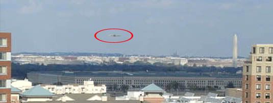
I still have to doubt that this is so, Colin being 99% sure or not, because when you turn this into an eyewitness account it falls apart. The main reason is distance: I took a crop of the picture CIT took from witness Timmerman’s apartment, which shows the Pentagon in the mid-distance and the Washington monument clearly visible across the river at 2.4 miles. But its height of 555 feet is 400 feet greater than the length of a Boeing 757. Here is how Flight 77 would have looked if it were flying near the monument, nearly 2 1/2 miles distant:
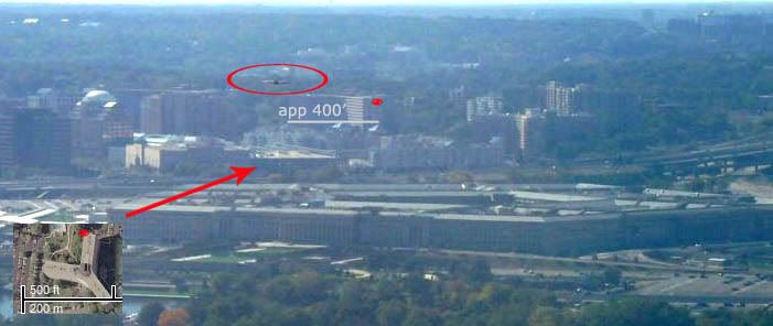
And here is an experiment in reverse, a view west from atop the Monument. The location the other photo was taken from is marked with a red eye on this 400-foot-wide building. Again, a 757 is slapped in to scale just above the building, 2.4 miles away.

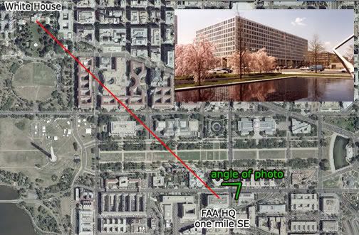
Now here’s the building Scoggins thinks the call came in from – FAA Headquarters on Independence Avenue in DC. At about a mile south of the White Hose and fairly near the Washington monument, they were calling in a report of a plane about five miles away from their ten-story building. Considering the experiments above, what would a witness at FAA HQ see five miles distant? Enough to report as a plane doing this and that? It's as likely to be reported as a gnat on the window, IF the witness was staring an inch from the pane. they certainly would be able to visually pick it out if they were first tipped off by, say, a radar report of a plane five miles southeast, er, southwest. But to notice it with no prompting makes little sense to me.

So I guess it doesn't really matter, but Scoggins could just have a false impression or imprecise memory, and then again he could be right. It is possible that some hawkeye saw it happening not terribly far away. It's possible but unlikely, and radar still seems right for this accurate but briefly inverted report of Flight 77's location.

Monday, May 12, 2008

SIX MILES SOUTHEAST

SIX MILES SOUTHEAST
Adam Larson / Caustic Logic
The Frustrating Fraud
May 12 2008
last update 5/14 12am


Citizen Investigation Team (CIT) now promote four primary claims regarding the decoy aircraft that everybody thought hit the Pentagon; First and foremost is their original North of the Citgo (NoC) claim, which necessitates the pivotal but otherwise unproven OtP (Over the Pentagon) claim (my own acronym, the others are theirs). This is also supported by the Over-the-Navy Annex claim (ONA) explicitly offered by Paik with supports recently wrangled from other witness accounts. And then there’s the tangential but important East of the Potomac (EoP) aspect, which is at issue in this article. As CIT co-founder Craig Ranke recently said “In addition to proving that the plane was on the north side of the former citgo gas station we can now also prove that it came from east of the Potomac River and actually flew over DC skies! This is absolutely fatal to the official flight path that never has the plane over DC skies at all.” [source]

I haven't tried so far to systematically debunk the EoP claim, perhaps out of fear that it would prove correct. When I finally decided to face my possible fear and finally tackle this case but found I cannot disprove it. It’s a strong enough case I don’t even feel like trying very hard, except on the one point I already did so with. I will have a fuller explanation of my general failure regarding EoP later, for now here is that one evidentiary support that I've looked at closely.

Ironically, this proof of the plane being over the river from where radar shows it is from - people whose job it was to watch where the radar was showing the plane. If CIT's reading here is correct, it would again prove the later-released radar data fraudulent, so it's a big deal. They cite the NORAD tapes, and a 09:35:41 call from Colin Scoggins at FAA’s Boston Center to Northeast Air Defense Sector (NEADS) base “Huntress.” [transcribed from audio]

Boston (Scoggins): “Latest report, aircraft [inaudible] six miles southeast of the White House.”
Huntress: “Six miles southeast of the White House?”
Boston: “Yup. [to someone else] East? He's moving away?”
Huntress: “Southeast from the White House.”
Boston: “Aircraft is moving away.”
Huntress: “Moving away from the White House?”
Boston: “Yeah.…”
[…questions on ID…]
Boston: “If you wanna hold on a second, [inaudible] people down there looking.”
[Long pause – to someone else] “Where was that position?” [backround on Boston end, inaudible with emphasis on last syllable rhyming with yes.]
Boston: “Six.. six southwest, six southwest of the White House and deviating away.” [emph in original]
Huntress: “Deviating away. You don't have a type aircraft, you don't know who he is…”
Boston: “Nothing, nothing. We're over here in Boston so I have no clue. That—hopefully somebody in Washington would have better—information for you.”


The direction of the original deviation isn’t clear other than ‘away’ from the capitol, but CIT is quite confident in placing the plane southeast of there and moving west, eventually crossing the river due south of the capitol, and continuing to six miles away on the other side in time for the update 35 seconds later of it being SW (it was either flying very fast or the second report was much fresher than the first). An alternate guess is it was never east of the river, and the change from southeast to southwest was a correction of the same last reported position.

I could just stop there by offering that guess, but when I tried to earlier, Ranke rebuffed it by stating of the above dialog “that wasn't an accident. He even confirmed it and THEN came back with an update of it being SW which makes perfect sense.” [source] I cannot prove that this is a wrong interpretation; perhaps Colin really was watching the real, pre-alteration radar data when it symmetrically traversed the river. And supporting this possibility is the fact that, as Ranke points out, “Scoggins wasn't the only ATC to report a plane east of the river either.” Oh no, his claim is supported by Major Kevin Nasypany, NEADS mission-crew commander, also from the NORAD tapes:

09:36:23
Nasypany: ‘I got a aircraft six miles east of the White House! Get your fighters there as soon as possible!”
Unidentified: “That came from Boston?”
[…]
Nasypany: “‘We've got an aircraft deviating eight miles east of the White House right now.”


Notice that this report follows Scoggins’ by only 40 seconds and someone feels it may have been based on that info from Boston. Is it possible he’s just repeating the report cited above rather than independently confirming it? Is "eight miles” an anticipated distance, an error, or real info? Does east mean southeast, or had it moved north? Most interestingly, if we take this as independent confirmation, it shows that that plane was not only east of the Potomac, but also deviating further EoP, rather than towards the river to cross west as CIT feels happened next.

Perhaps it’s all a complex cover-up where they altered some parts of the record to hide the real plane while other parts are let through, to provide cover for something, or something. I can’t rule this out as a possibility, but my tentative alternate guess – for whatever it’s worth – is that the report Scoggins received had one error - southwest was reported as southeast, and both Scoggins and Nasypany just echoed this error. A bit of confusion is evident in what Nasypany said later to Vanity Fair’s Micheal Bronner: "Six miles south, or west, or east of the White House is—it's seconds [...] Airliners traveling at 400-plus knots, it's nothing. It's seconds away from that location." That is, they weren’t worried at the moment about which direction the hostile craft would have to fly for a few seconds to hit the White House – they were worried about how few seconds that was, and how to get fighters to that small area fast. They did sort out the error, if that's what it was, but the fighters didn't get there 'til far too late.  

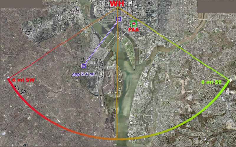
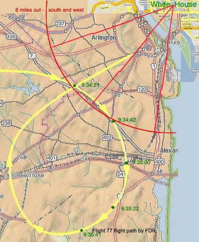
Anyway, you can test this east-west error reading here: refer to this graphic of the radar flight path, marked roughly with lat-long cross-points from the FDR (corrected and approximate), and a 6-mile arc south and west from the White House. Then read the reports below, corrected. update: As explained in the comments below, 6 miles meant nautiical miles which - I think - is about 7 land miles. So note this - the red arc is set a bit too small.

Scoggins 9:35:41: “Latest report, aircraft [inaudible] six miles southwest of the White House.”
“Yup. West—he's moving away? Aircraft is moving away.”
“Six.. six southwest of the White House and deviating away.”
Nasypany 9:36:23: "I got a aircraft six miles [south]west of the White House! […]
We've got an aircraft deviating eight miles [south]west of the White House right now.”


One word, one dyslexic slip in the information chain, is all it takes to turn this into a brilliant indication that the above path is the one seen by radar controllers on 9/11. On the other hand, a different reading could, with a few complications, be found to support the EoP claim, which, again, I still cannot disprove.
---
Update: SPreston has used this "six miles southeast" evidence to say the FDR path is PROVEN a lie.:
"PROVEN: This Flight Path Crossed Over the Potomac, Over DC, and Six Miles Southeast of the White House [...] How come all the witnesses actually interviewed place the actual aircraft east of the Potomac and over Washington DC and 6 miles southeast of the White House and banking around Reagan National? "
None of the witnesses says this that I've seen. One has it looping around from the east (Chaconas and he alone) and this location and distance is not from any interviewed witness, but from the above-described possible error. Almost all other witnesses were west of the Potomac (a few just east as well but looking west). SP, help me out if I'm missing something! Comments open...

Friday, January 4, 2008

THE LIGHT POLES

Clipped or Staged?
Adam Larson / Caustic Logic
The Frustrating Fraud
Last Updated Jan. 7 2008


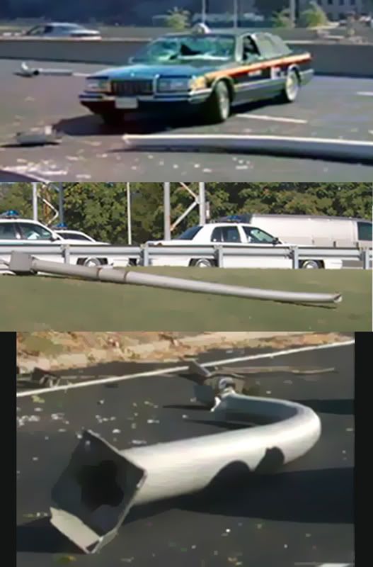
In denying a 757 impact at the Pentagon on 9/11, Loose Change looked at, among other things, the five light poles said to have been shorn by the wings of Flight 77 just before impact. The video cited previous problems when planes hit light poles - pole left damaged but standing, wing comes off, plane crahes. “And yet Flight 77 managed to tear five light poles completely out of the ground,” Avery continued, “without damaging either the wings or the light poles themselves.” How precisely he knows that the wings were undamaged on the plane he believes doesn't exists is left unexplained, but to prove the poles were untouched, they had hard proof - actual photographs, including those at left. A look at the very photos they used proves the assertion flat wrong. If these light poles aren’t damaged, why don’t they have lights on them? [at left: pole 1, pol 4, and pole 1 again. below right, pole 5.]

Clearly if a Boeing 757 with its 125 feet of wings came swooping in over the highway, it’d cut some poles – but since they insist on seeing no plane, the Loose Change people summarize that the undamaged poles “seem to have just popped out of the ground.” The only implication I can see in this is of a covert Pentagon system of specially designed poppable light-poles to fake a cruise missile/drone strike out to look like an airliner attack. I guess it’s possible, but the photos show that this system also seems to mangle the tops of the poles on the way down, which they would have to to effectively fake an airliner attack, thereby proving fallacious the whole issue which started by insisting there was no such damage.

This is perhaps the most-widely-cited graphic analysis of the light pole arrangement, which of course aso coincides with the 'official' flight path. This graphic was made in 2002 or so by UK 'debunker' Ron Harvey. Another researcher, Dick Eastman, first doubted the poles' existence: "Ron Harvey says that 5 poles were downed. Ever hear that from any other source? I saw eye witness testimony that one pole was "clipped."" [link] Later he admitted their existence; "The poles not a question that is in dispute. I have long acknowledged the existence of the poles as soon as I finally got my hands on an actual picture of one (Ron Harvey was not forthcoming with me at the time) -- in fact it was the pole data in contrast to the witness accounts that first suggested the presense of two converging aircraft paths." [link.] One had a swooping 125 foot wingspan backed by 100 tons of force - and flew well above the poles, which were knocked down by air vortices off the wingtips of his F-16 killer jet.


Russel Pickering's analysis at PentagonResearch.com found that they were 27.66 feet high, made of .188 inch-thick aluminum, 8 inches in diameter at the base and 4.5 inches at the top and topped with 70 pound lampheads. The reason the wings wouldn't be damaged is because the use of a "breakaway style" pole design. As Pickering explains: "this limited damage factor is why the FAA requires these type of poles in the "safety zones" around airports and helipads. They recognize that this type of pole minimizes damage to aircraft." He cited the FAA's rules: "any structure located within 250 feet of runway centerline has to be frangible, which means the structure needs to break away when hit by an aircraft to minimize damages to the aircraft and its pilot."

I have done my own anlysis now on poles 1 and 2 (pole 1 being the one that allegedly speared Lloyd England's windshield). I deduced a slightly different pole height than Pickering, although he's probably right and, along with tree damage and a slight mark high on a camera pole, have mapped out a rough outline of the plane's apparent bank at that moment - right-high, like the witnesses all have said.


If these were faked, they were faked well, The PentaCon video in 2007 made the case that the light poles were staged to fake the official attack path, and poorly so at that, bearing dozens of effects errors. Largely a rehash of Eastman's early theory sans the killer jet and beefed up with better witness pool, the video and its makers propose the poles were cut down, crimped, and in one case curved, some point perhaps weeks in advance, hidden in the bushes unnoticed, and dragged out for the attack in the morning. Or something to that effect. The one that hit Lloyd England's taxi was trickier, and they go to great length to explain the conspiracy behind this, or at least to argue there must be one. As PentaCon producer Craig Ranke (aka Jack Tripper) explained:

"If you accept that the plane flew on the north of the station you MUST accept that ALL the physical damage was staged/simulated/fabricated. Therefore, because the light poles line up perfectly with all the physical damage to the building there is no reason to suggest that any natural force [...] or projectile at all brought them down. They were simply removed and planted BEFORE the event."

That's of course one of the many reasons I do not accept the north side flight theory.

Wednesday, December 5, 2007

9:32 EVENT EVIDENCE ADDRESSED

PENTAGON ATTACK TIMELINE QUESTIONS PART 3: 9:32 EVENT EVIDENCE ADDRESSED
Adam Larson / Caustic Logic
The Frustrating Fraud
December 5 2007 3am
last updated 8/10/09


All The 9:32 Duckies Lined Up
In the previous post I established the overall logic (found wanting) of the claims for a 9:32 attack at the Pentagon, vs. the official time of 9:37:45. Now it’s time to analyze the evidence that is behind all this theorizing; something got people wondering ‘what happened at 9:32?’ We’ve looked at the two frozen clocks a bit, and will return to them by the end, so let’s start with the yet-unexamined supporting evidence first. If some major violence happened at that time and was covered up, it might leave traces pointing at some kind of coherent reality. Until he was temporarily banned and then seems to have stayed away, LCF member Terral hammered away at a nine-point list of evidence for his 9:31:39 missile impact [1], based on Barbara Honegger’s five-point list of a pre-plane bombing at about that time [2]. Analyzing the two together and dismissing those that have nothing to do with a set time of about 9:32 I have identified seven points, including the clocks combined as one point. Supports attempted for 9:30 I have disregarded as too early to fit this model and will be addressed separately in a later post.

The meat and potatoes of 9:32 evidence is as follows, as debunked as I care to try for along the way:

1) An Early FAA Chronology: A Federal Aviation Administration (FAA) document called Executive Summary - Chronology of a Multiple Hijacking Crisis - September 11, 2001 reported that at “0932 ATC AEA reports aircraft crashes into west side of Pentagon.” [3] Assembled just six days after the attacks, this official report’s stated time has since been amended – cover-up or correction? ATC (air Traffic Control) means radar; they don’t see things crashing, just disappear from screens, which happens when it drops below a certain altitude. In the case of the Pentagon attack, it appears the plane dropped off screens at 9:37:15, 30 seconds before impact, not the 5-6 minutes before required for this report to be correct. Many have taken this as a temporary slip and admission of reality - but one still openly available despite its damning implications.

Another likely possibility is that this report was somehow wrong, perhaps a confused report reflecting, for example, the 9:34 call mentioned by Gaffney in the previous post– “American 77's lost […] they lost radar with him. They lost contact with him. They lost everything. And they don't have any idea where he is or what happened.” [4] It seems likely to guess it crashed – perhaps this report was hasty and based on some initial report to this effect without double-checking – and not necessarily a clue of anything.

Regarding early FAA reports from 9/11 and their relevance on timeline questions, for Flight 11 they reported (at one point, it's also since been revised) a shooting of passenger Daniel Lewin at 9:18 am (it had crashed at 8:46, documented and uncontested) and then “at 9:25 am, this flight crashed directly into one of the towers of the world trade center.” [5] Compared to AA’s flight 11 mix-up (possibly the origin of the ‘Phantom Flight 11’ that distracted defenders from the real threat of Flight 77), a single mis-citation of 77’s crash time is quite mundane.

And besides, it seems highly unlikely that ATC with their radar screens would report a non-plane related 9:32 explosion, however they may have heard about it, as evidence for the disappearance of a plane they were tracking - So this evidence’s connection to Honegger’s case is less than clear.

2) Per Stig Møler: The son of two Danish parliamentarians and a member of Det Konservative Folkeparti [6], Møler was in Washington, D.C. on 9/11, two months prior to his being appointed Foreign Minister of Denmark. The morning of the attack, Honegger recounts, “he looked out, heard an explosion and saw the smoke first rise from the Pentagon. He immediately looked at his watch, which read 9:32 am. He gave radio interviews in Denmark the next morning in which he stated that the Pentagon had been attacked at 9:32.” [7]

This seems to be good evidence; one would think if his watch was five minutes off, he'd know that and correct for such a momentous occasion. Or is he simply embellishing the watch check, and actually filling in the time based on some flawed source? [The FAA’s chronology would not be released or days, so that’s not a possible culprit]. Or is Honegger inserting the watch embellishment herself, while Møler only ever said it happened at 9:32? Her sources was listed as “interview with Denmark Radio P3, September 12, 2001, 6:15 am Denmark time.” The excerpt she included said “I saw smoke and fire rising from the Pentagon at 9:32...My first impression was that a bomb had been detonated at the Pentagon.” That in itself doesn’t clear things up, and being disinclined to find the original audio and get it translated, I’ll leave this point as vague at best.

Update: Someone named Josarhus from Denmark checked out the interview, joined and started a thread at the JREF forum about this:
Further more Per Stig Møller CLEARLY states that he thinks the time was around 9:32-9:34 based on when the meeting was supposed to end. The meeting was supposed to end at 9:30, but he didn’t look at his watch. In other words the time could very easily correspond with the official time of the crash.

To make it short, if anybody in the future claims that Per Stig Møller said that he heard an explosion and saw smoke and flames 5 minutes before the plane hit the Pentagon, tell them that the claim is based on an incorrect translation by the Dane Henrik Melvang and on deliberate distortions by Barbara Honegger.


3) Robert Andrews Top Civilian at Pentagon and director of “Special Operations” under Rumsfeld, Andrews shared with Honegger another wristwatch recollection. He told her in an interview that he had been in the Pentagon’s basement when “a violent event caused the ceiling tiles to fall off the ceiling and smoke to pour into the room. Andrews immediately looked at his watch, which read approximately 9:35 am but which was set fast to ensure timely arrival at meetings, so the actual time was closer to 9:32.” [8]

Barring another embellishment by the author (who does seem unable to provide direct quotes where witnesses clarify they got the time from their watches), this is quite specific and good evidence – almost too good. A Rumsfeld aide tells us the event occurred at 9:32. I'm starting to wonder if there really is a pattern behind all this evidence besides coincidence, but that it’s closer to Pentagon disinfo than emerging reality. If so, Rummy's 'missile-transcription” set the trend. Does ‘special operations” include disinfo work? Otherwise, maybe he just misspoke and said 9:35 when he meant to say 9:45. Then he could be referring to the 9:38 plane impact or to the later explosion around 9:43, depending on just how far ahead his watch was.

4) Al Gonzales Before becoming Attorney General, White House Counsel Alberto Gonzales gave a lecture at Honegger’s Naval Postgraduate School in which, as Honegger noted, “Gonzales explicitly and clearly states that “The Pentagon was attacked at 9:32”. [9] It’s matter of public record and probably true that he indeed said this, but I don't see why it necessarily means anything. He may have just read an erred report – like the FAA’s cited above – while doing his background research for the speech. Or if there were an official effort to seed this idea, as suggested by Honegger's Andrews interview, there's no good reason to rule out Gonzales deciding to affirm it almost to Honegger's very face for her later use. For the moment I'll stick to the more innocent explanation.

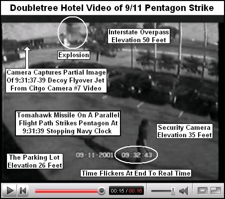
5) The Doubletree Video Timestamp:
Neither the Pentagon nor the plane that hit it are visible in the Doubletree security video; with its view blocked by the raised roadway nearer the camera, only the massive column of fire and smoke in the distance gives us a clue that the Pentagon was struck at – 9:32? The video is very glitchy; an onlooker in the lot also blinks in and out of the screen twice and a totally different camera view of another parking lot comes and goes and later wrestles for dominance with the main view. The time-stamp is as jumpy and flickery as the picture but moves unsteadily along a natural timeline stamped 9:34. As the explosion rises at 9:34:42, the timeline then flickers to 9:32:43, which hold for one second until rolling back to 9:34:44. [10] A minute change precisely at the second rollover, simply showing a 2 instead of a 4 during that slot seems just a glitch; the date field also changes for one second at different points. 09-11-2001 briefly turns to 9-03-2001 (at 9:30:54). No one has yet claimed this as evidence of an explosion at the Pentagon eight days early.

Passing up the chance to make a fool of herself again, Honegger failed to include this anomaly of the minute space as evidence for here case, but 9:32:43 was taken up enthusiastically by Terral and analyzed (see above, his graphic) as another solid proof of his 9:31:39 event. “The proof is in the pudding,” he explained. “The Double Tree Security Video shows signs of monkey business. :0) I cannot tell you ‘why,’ but can show you ‘what’ the evidence clearly reveals from the 9:32:43 AM recorded explosion taking place […] This is another case of the ‘evidence’ supporting my 9:32 AM “first explosion”” hypothesis.” [11] Terral clearly is implying it was altered from 9:32 except for that frame, but as I asked him, “why would they 'alter' the time of the 9:32 blast to look like the 9:38 blast, but change the time to 9:34 instead and then let it flicker back to 9:32 at the end? What on Earth can this prove?” [12] Proof by glitch as further 'corroboration’ of a 9:32 event. He even used the quotes himself, and included that trademark clown face emoticon. This is just how seriously the case deserves to be taken.

6) April Gallop’s watch: A third wristwatch recollection related by Honegger Is that of April Gallop, an “Army employee with a Top Secret clearance,” had stopped by her office with her newborn son Elisha when her section exploded. Honegger’s point in including this curious witness was that “Ms. Gallop still has the watch she was wearing that morning, which stopped shortly after 9:30.” [13]

April certainly went through hell that day, with her baby, and suffered serious injuries to her right leg I believe, so it’s possible her watch was mechanically stopped by something that hit her arm as well. And if so, we have another stopped clock showing a time closer to 9:32 than 9:38. Given what Gallop went through, it may seem cold to cast aspersions, but of all the points on this list, she is in my opinion the most compromised by mis/disinformation concerns. Among the oddities of her account(s), she later told Jim Marrs “I know what a bomb sounds and acts like, especially the aftermath, and it sounded and acted like a bomb. There was no plane or plane parts inside the building, and no smell of jet fuel […] I figure the plane story is there to brainwash people.” [14] She’s also helped promote the PentaCon, and has described climbing out through the entry hole, which she has elsewhere incorrectly verified as “perfectly round” and “didn't appear to be big enough for the 757.” [15]

Even Terral knew not to touch this point, and she was not included in his five-point list. He explained “I omit Ms. Gallop’s testimony from my work entirely, because the other ‘clock damage’ appears to be from the ‘concussion’ of the explosions and not from an electromagnetic pulse (EMP). That means Ms. Gallop needed to strike her wrist against something at this critical time to stop the movement mechanism, OR my EMP suspicions are inaccurate.” [16] Okay, perhaps credibility was not his reason, but it should have been.

7) Those Clocks:

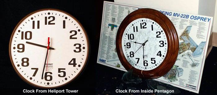
The pivotal evidence that started the whole search for a 9:32 event is that double-corroborated time recorded on those two famous clocks. This point has also proven the hardest to debunk with certainty. Since I have no solid rebuttal, and since this post is already too long, I'll just summarize what's up with that. Pickering seems to suggest mechanical damage after 9:32, with the diesngaged minute hands falling with gravity towards - but not quite to - the six, and proferred a challenge for anyone to try it at home and videotape the results. [17]. To my knowledge no one has taken him up (I have a clock but need to borrow a camera). In short, I have no sure answer for the clocks showing the wrong time. Just on their own strength, the possibility that they're right must be considered. Therefore, these seem to me the main possibilities:

1) Both clocks were about right and stopped at the impact time around 9:32
2) Both clocks stopped around 9:38 but were six minutes behind by sheer coincidence
3) Both stopped at 9:38 but the mechanism was broken so the minute hands only swung back towards the 6 or something to that effect.
4) Subtle psyop to confuse people: “be sure to move than hands back to 9:32 before the museum guys pick it up…”
5) Combinations and permutations – one was six minutes behind, the other broken, etc.

Why Not 9:32?
Some might wonder why I would bother dismantling this timeline construct. After all, if 9:32 were proven, a massive lie would be uncovered that could unlock yet more secrets. The problem with this case is that no matter how solid it seems at first glance, compared to the 9:38 case, it absolutely fails to hold water. With so little supporting evidence that pans out to suggest anything in particular happening at that time, two clocks does not a valid alternate make. Even if we ignore Honegger’s silly and unsubstantiated bombing/A3 attack, or Terral’s missile/flyover-and-A3 attack, just taking the first explosion at 9:32 as from the 757 impact (ala Gaffney), dozens of points of data had to be shifted ahead to around 9:38 for no good reason I myself can see. The next post in this series will endeavor to show just how much corroborating data would have to have been coordinated to bolster the official timelie. It’s really quite a bit…

rest coming...

Sources:
[1] Posted by Terral. Oct 15 2007, 04:02 PM. Loose Change Forum -> 9/11 Research -> The Pentagon -> “Best Evidence Of The Time Of Pentagon Explosion” -> Page 1. http://z10.invisionfree.com/Loose_Change_Forum/index.php?showtopic=16133&st=0
[2] [7] [8] [9] [13] Honegger, Barbara. The Pentagon Attack Papers: Seven Hours in September: The Clock that Broke the Lie. Appendix to The Terror Conspiray by Jim Marrs. Published September 6, 2006. html link - PDF link
[3] Federal Aviation Administration. Executive Summary - Chronology of a Multiple Hijacking Crisis - September 11, 2001 September 17 2001.
http://www.gwu.edu/~nsarchiv/NSAEBB/NSAEBB165/faa5.pdf
[14] Marrs, Jim. Inside Job. Origin Press. 2004. Page 26.
[17] Posted by Russell Pickering, September 20 2007, 12:32 PM. Loose Change Forum -> 9/11 Research -> The Pentagon -> “Clock Question - Did Internal Explosions, Stop the clocks 5 to 11 minutes before…” -> Page 1. http://z10.invisionfree.com/Loose_Change_Forum/index.php?showtopic=15994
rest coming...

Tuesday, April 10, 2007

PILOT X AND THE 440 FOOT GAP

FLIGHT 77 ALTITUDE QUESTIONS
Adam Larson
Caustic Logic / The Frustrating Fraud
April 9 2007
last edited 4/15 @ 9:32 pm


In mid-2006, new doubts about the five-year-old Pentagon attack were found, built right into a government-produced animated flight path of AA Flight 77. The group Pilots For 9/11 Truth (P49T) have been able to capitalize on the inherent contradictions in this CG cartoon - most notably in their January 2007 video Pandora’s Black Box Chapter Two - to somewhat convincingly suggest an entirely new flight path that in different (and often contradictory) ways, disproved the official flight path and, if correct, make the plane’s impact a steep improbability. [I'm working on more detailed posts about both sources and discrepancies]. The latitudinal aspect of the new 757 denial trajectory, the apparent flight well to the north of the official path, is one anomaly in this animation, but will be covered elsewhere. Here we’ll focus on the altitude questions, which are, no pun intended, a little over my head and the heads of others, a fact that at least one side in the debate seems to be using to its advantage.

The animated video file was based on the flight data recorder (FDR) of the doomed 757, rendered by the National Transportation Safety Board (NTSB), and released in mid-August 2006 via a FOIA request by a P49T-affiliated researcher. By August 20, P49T co-founder Rob Balsamo (aka John Doe X) had come into possession of the damning flight simulation and wrote about it at the group’s site. The final frame was key: it shows the animation stopping abruptly, as the original data supposedly did, with the plane on-screen still hundreds of feet away from the Pentagon and still far above it. Time at this location: 9:37:44, the second before the plane is supposed to have hit the building. While at that very second the CCTV camera north of the attack path was snapping a plane cruising in about five feet off the ground, the onscreen altimeter reads 180 feet. The plane in this animation could not have hit the Pentagon, at least not at the official time. It would have been several seconds late by the speed and descent rate up to that point. But it cuts there, at about the right time but quite the wrong place, and we were thus prevented a glimpse of the fly-over, the secret landing, and the safe removal of the FDR to be planted back at the Pentagon. (??) These are the gaps we must fill in to reach the "Truth."


Screenshot of the final frame: The time is ajusted to GMT, not EDT, so 13:37:44 should read as 9:37:44. The resolution here is easier to read than in the low-res video of the final maneuver available for free viewing online here

Balsamo explains: “You will notice in the right margin the altitude of the aircraft on the middle instrument. It shows 180 feet. This altitude has been determined to reflect Pressure altitude as set by 29.92 inHg on the Altimeter. The actual local pressure for DCA at impact time was 30.22 inHg. The error for this discrepancy is 300 feet. Meaning, the actual aircraft altitude was 300 feet higher than indicated at that moment in time. Which means aircraft altitude was 480 feet above sea level.” [1] This is also 440 feet above the ground. Thus “the 5 frames of video captured by the parking gate cam is in direct conflict with the Aircraft Flight Data Recorder information released by the NTSB.” [2]

As John Doe X, Balsamo has put together several long – and lonely - posts explaining this true altitude conclusion at the Pilots’ site, and apparently has been pretty aggressive in promoting and defending it elsewhere. [3] I haven’t been able to independently verify his 300-foot correction, but initially guessed it was quite possibly correct. Either way, there is a re-set protocol; from what I gather of the reason behind this, FAA regulations mandate pilots use local atmospheric pressure settings when in the lower, more crowded airspace – below 18,000 feet (FL180). Above that point they re-set to a baseline pressure setting of 29.92. On its ascent, we're told, both the animation and the other data show Flight 77’s altimeter re-set from local pressure (30.21) to 29.92 at about 8:28 am). Pandora’s Black Box shows an altitude drop at that point from 18273 to 18058, a difference of 215 feet; so a rise of perhaps 300 feet when switching back to a nearly-same presure setting on the descent seems plausible, but the corresponding, FAA-mandated re-set is not shown in the animation, and hence the cover-up.

This may not seem surprising – why would Balsamo suspect there should be such a re-set despite the change of control from FAA-certified pilot to suicide hijacker? The reason he has a problem here, and really its own problem, is the other P49T data, also obtained separately by FOIA request, indeed did show the re-set from 29.92 to 30.23. Balsamo summed up the non-animated data “show[s] the altimeter being set in the baro cor column on the descent through [18,000 feet].” [4] I’ve checked and it does. Taking that as truth, the Pilot(s) asked the government why “the animation altimeter does not show it being set?” The question was rhetorical; the answer they had already decided on was that the omission was to make a strike look somewhat less impossible; “this is a blatant cover-up to confuse the average layman in hopes no one would adjust for local pressure to get True Altitude. Too bad for them we caught it.” [5]

A member at JREF named “Anti-Sophist” who describes himself as an Air Force trained flight data expert and electrical engineer, summed up of "JDX"s 300-foot correction “if his true altitude number is correct, he is actually on to something, […but…] No one seems to agree with his "true altitude" calculation except for him.” [6] To see what effect the "cover-up" had, and to help clear up which impossible altitude seemed more likely, I looked into the Pilots’ comparative data, a CSV file for Excel, called AAL77_Tabular, where the pressure re-sets at 18,000 feet are recorded each way. This document forms the basis of my FL018 research (thread coming), but I have yet not been able to independently verify its authenticity. Oddly enough, the recorded altitude does not change at all with the adjustment and there is no meaningful discrepancy!

Ascent:
time - Hg - alt
8:27:58 30.21 17938
------------------------------ FL180
8:28:00 - 29.91 - 18015
8:28:02 - 30.21 - 18093
8:28:04 - 29.91 - 18170
8:28:06 - 29.94 - 18247
8:28:08 - 29.91 - 18324
8:28:10 - 29.92 - 18402
8:28:12 - 29.91 - 18483

Descent:
time - Hg - alt
9:24:12 - 29.91 - 18205
9:24:14 - 29.92 - 18126
9:24:16 - 30.23 - 18049
------------------------------ FL180
9:24:18 - 30.01 - 17972
9:24:20 - 30.23 - 17895

The pressure was reset at 8:28, with no 300-foot drop in altitude, and re-set on descent, again with no effect. Yet it shows essentially what the "altered" animation shows at termination: 173 feet compared to its 180. [7] So the data here shows two pressure re-sets, 302 feet at takeoff, 173 at the end. The animation shows 300 at takeoff, ONE reset, and 180 at the end. The pilots insist the data and animation match except for "the blatant cover-up" of neglecting the second re-set, turning the data's real alt of 480-ish to 180. But in reality, the animation and this CSV file match from A to Z despite the alleged cover-up and that extra 300 feet is looking like a red herring.

But even without Pilot X’s "correction," a Pentagon attack could not have occurred by a plane that far from the building, and that high, by either the CSV file or the animation. Considering this animation also shows the northern flight path that rules out this plane reaching either the Pentagon or the light poles before it, a whole slew of glitches, or perhaps some other explanation, would be required to debunk this damning NTSB-supplied animation.

One interesting tack is to compare all available sources, check their degrees of authenticity/verifiability, and then compare which comport with which and, as Sesame Street used to urge us, find “which one of these things just doesn’t belong.” There is an investigation of this underway, going very slow so far but it should be up soon.


Sources:
[1], [2] Flight Data Recorder Analysis - Last Second of Data - 09:37:44 08/20/06 http://pilotsfor911truth.org/pentagon.html
[3] John Doe X. Fdr Vertical Speed, Altimeter lag issues addressed as well. Pilots for 9/11 Truth forum: Flight Number: American 77. Posted October 15 2006, 08:41 AM http://z9.invisionfree.com/Pilots_For_Truth/index.php?showtopic=106&st=0&
[4], [5] Questions for the US Govt regarding AA77 Flight Data Recorder. Posting date unlisted
http://pilotsfor911truth.org/pentagon.html
[6] “AA77 FDR Data, Explained.” Posted by: Anti-Sophist. October 13 2006at 9:10 pm. http://forums.randi.org/showthread.php?t=66047
[7] AAL77_Tab - Excel document - downloaded from: http://z9.invisionfree.com/Pilots_For_Truth/index.php?showtopic=64&st=0&