Adam Larson / Caustic Logic
The Frustrating Fraud
February 15 2008
updated 2/26 2am
Do You Even Know What A Bank is? Just Curious.
- Craig Ranke: "The plane banked over the Navy Annex [...] Did you know that even Mike Walter claims the plane banked?"
- Craig Ranke: "a bank in his view AT ALL completely destroys the official story."
- Aldo Marquis: "Ever speak to Mike Walter about seeing the plane in a bank? Just curious." [source for both]
He asks because they did speak to Walter about the bank! At JREF back in April 2007 Ranke (as Lyte Trip) posted this text and graphic:
"He contradicts the official flight path. He claims he saw the plane do a "graceful bank" before gaining speed and flying into the building. There would be no "bank" in the official fllight path whatsoever that he could possibly see on route 27. But there most certainly IS a bank in the eyewitness flight path that we report!" [emph mine]
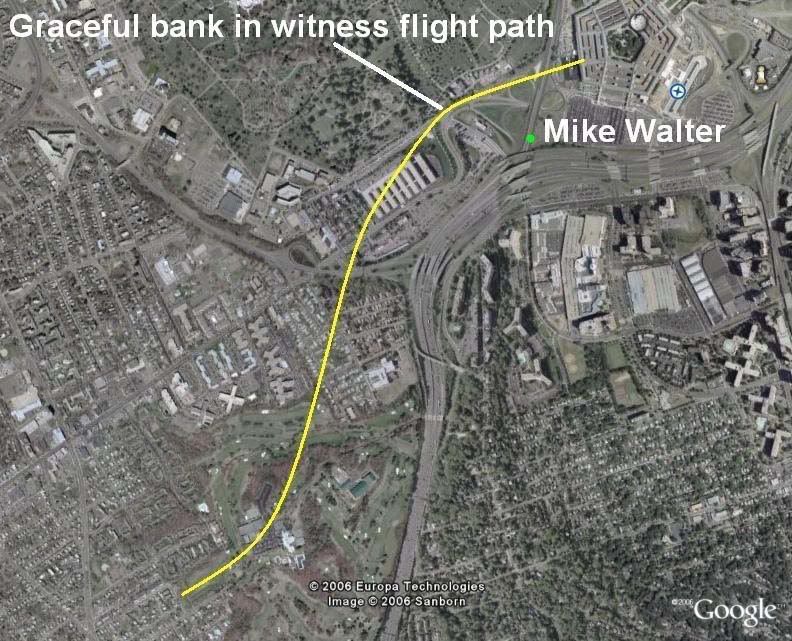 So Mr. Trip and his fellow citizen would have us believe that in the 'official story' "there would be no "bank" [...] whatsoever that he could possibly see on route 27." This is flat false. To understand what's up with this I need to clarify some confusion/conflation. To some minds a 'bank' is indistinguishable from a 'turn,' but a turn, as we all know, is a general changing of direction, while bank is:
 "The angle between the wings and the horizon, as viewed from the rear of the airplane. An airplane with its wings level has zero degrees of bank. [...] Banking makes the plane turn. [...] This process is also called Roll." [source]
There is a natural, inevitable correlation between the two; usually banking means a turn just like smoke means a fire. However, just as smoke and fire are two different things, so are these two, and they can in fact be separated. A quick scan of anecdotal evidence - googling "bank without turning" and variations for about two hours - shows that its possible, and involves countering the tendency to turn using the rudder. In fact the rudder seems to be the key to both turning without banking and banking without turning. The best explanation I found is this, by Peter Sagar.
So when someone describes a plane 'banking,' they could possibly mean it colloquially as a turn, or they could mean - well, a bank of the wings, depending on the witness. This is a very important point to remember as we progress here, and when reading the analysis of Ranke and Marquis of Citizen Investigation Team, who make no such distinction. When they hear or say 'bank' they think or mean a turn, and refer to actual bank as 'tilt'. I've never heard them discuss tilt that I can recall, just bank, of course meaning turn. [explanation extracted here]
Discerning then the difference between the angle of a plane's wings and a general change of direction over space, let's address the normal relation between the two. If the right wing goes up, the left wing goes down, and the airplane is said to be in a bank to the left, and will naturally turn to the left. Any kid who zooms around on a bike will understand the concept. There are certainly formulas for bank/turn ratios, but in general, a level plane will go straight, and the steeper the roll, the tighter the resultant turn. How it's measured is seen from behind - right wing low is a positive number, and right high is a negative number. The tilt is measured in degrees, with level wings being 0 and wings straight up-and-down (plane sideways) being 90 degrees. Airliners try to stay level - a bank of 40 degrees is considered extreme, remarkable, rarely-seen, memorable, etc... Please keep this in mind.
Official Bank?
As CIT point out, the official story delivers a straight-shot path, about 70 degrees magnetic, 60 real, for at least two miles prior to impact. Therefore, any bank angle in the final stretch would be slight, or otherwise offset to keep straight. 'Straight' in this case is relative - the path may have had a slight bow that was not noticeable on the small scale most people saw it on. So in CIT terms, a straight line means no bank, and no bank probably means no tilt.
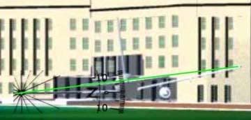 While there is no discernible turn in the official version of the final stretch, CIT will be saddened to learn that there is a bank [tilt] in the 'official story,' recorded in the physical evidence. A roll of about -6 degrees is evident in the wing prints at the facade impact point (IMO a bit more level and a few feet higher than shown here - ASCE graphic measured by me). This bank is generally consistent with the right-left damage before impact: the VDOT camera pole, tree damage, three light poles, diesel generator, etc. encountered by the right wing and engine at their respective heights, and two light poles, vent structure, trailers, and building foundation encountered by the left wing and engine. Though exact numbers are hard to deduce and the minutiae hotly debated, it's all consistent with a slight left bank like that shown here.
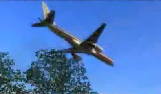 Due to the confusion over terminology, and other factors, debating this issue with CIT has been baffling, as they flatly state 'so-and-so wasn't in a position to see the bank,' etc. Couldn't see the bank? For God's sake, I railed... here's their own flyover animation: If I were right there being fooled by the flyover, nothing could fool me about its bank – about zero, perfectly level. So to be clear, they mean 'turn' in these cases and it makes sense that few witnesses would see a whole turn on the scale of even their tight yellow swerve. But since a turn is a change from one heading to another, and marked by a wing tilt as they call it, their recent eagerness to deny witnesses can see headings at all and their silence on 'tilt' are troubling. This leaves their findings very vague - and malleable.
 FDR Insights
The numbers recorded for 'roll' in the original CSV file readout of the flight data recorder obtained by Pilots For Truth and others are instructive in what to expect in the last moments as far as turn and tilt. This quick list shows key points before and during its final turn (9:34-9:37, a right bank for nearly a full circle) and end of data:
h:mm:ss - roll
9:32:55 – +3.5
9:33:46 – +1.1
9:34:01 – +8.1
(nearly 8 degrees change in one second! The loop starts here.)
9:34:38 – +29.5
9:35:55 – +37.6
9:36:32 – +16.9
9:37:10 – +10.9
9:37:20 – +2.8
9:37:30 – +3.2
9:37:35 – +2.1
9:37:40 - -0.4
9:37:41 - -0.7 (-0.3 change/sec)
9:37:42 - +1.1 (+1.8 change)
9:37:43 - +3.5 (+2.4)
9:37:44 - +6.3 (+2.8)
[note: C-130 pilot Steve O'Brien estimated the plane's bank as he passed it as 30-40 degrees. By radar he passed it around 9:35-9:36. See above for comparison.]
At 9:37:36 the magnetic heading first hits 70.0 degrees and thereafter is steady, alternating between 70.0 and 69.6. Roll at that time is nominal and then shifting even to a slight left bank, back to right near the end, and then what? A final reading of 6.3 would mean right wing was tilted down to about the same degree the physical evidence has it tilted up, as Pilots For 911 Truth have celebrated. But the FDR is no help in this area – it stopped recording, or was truncated, or something, shortly before that point, somewhere in the neighborhood of 6-8 seconds shy of impact, which would have been around 9:37:50-55. With 12-13 degrees change required that’s about 2 degrees/sec or less, which fits previous trends quite reasonably. But this is all guess work... the machine is silent, and we have the physical evidence and the eyewitnesses, one of which we've covered.
Eyeballs on Wings
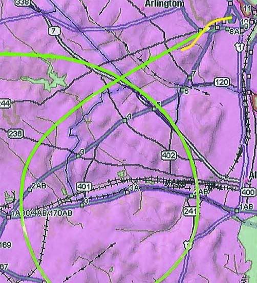 So in establishing turns, even if we're calling them banks, it's important to note the direction of the bank. The CIT witness-adduced swerve is shown above in yellow, to scale with the 'official' loop in green recorded by FDR and radar from 9:34-9:37. Check the sample rolls above at these times, and realize the CIT swerve would require a sharp left turn over the driving range, in excess of 40 degrees, a rapid correction, then an equally sharp right turn over the Navy Annex, so a right bank, with left wing very high.
 One witness CIT is very excited about, Sean Boger, with a prime view from the heliport, does seem to describe this: "As he was coming towards me it just seemed like he was tilting the aircraft to his right." Barring some confusion (tilted meaning up or down? His right or the plane's?) this sounds great. But he also puts the plane north of the Citgo, so a grain of salt is in order. I also note that as an aviation pro, Boger might've been expected to use the proper term bank, but instead chose the more vague 'tilt' which CIT settled on, as supporting the plane's right... bank.
Which it would, of course. Right tilt-bank means right bank-turn, and this is supported by others in conflict with the official story. Like Mike Walter we hear. LCF part-time member Bileduct calling CIT on using Walter's banking report: bileduct perma-banned, thread closed. In this well-managed thread, Bileduct ejaculated: "You have indicated that Mike Walter described the plane in a banking maneuver over the Navy Annex. Your exact words were "He described the bank in detail to me, Aldo, Dylan, and Russell." My question for you... Did he say the plane banked to the left or the right?" To this simple question Craig responded "To be honest I don't remember. […] But I do recall that he had the plane making a "graceful bank" as it approached, not directly in front of him." Bileduct gloated for a moment then posted one of Walter's published accounts:
"I will never forget that day, trapped in traffic and then I rolled down the window and heard the sound of the jet overhead. [...] I looked up and saw the underbelly of the jet as it gracefully banked, then I watched in shock as the jet basically lined up the Pentagon in its sights and began to scream towards the mammoth structure." [emph mine]
'Underbelly' means it was above him - obviously - and also tilted at least somewhat right wing high. This is a left bank, not a right one, in which case its belly would be turned away. And that this happened in the distance - where the hairpin tirn to the right was supposed to be happening - was doubly troubling. Craig quickly responded "I do not believe or trust Mike Walter for a single second and we have plenty of evidence to show deliberate contradictions in his account. [...] He could not see the underbelly. He did not see the underbelly. He could not have seen the underbelly or a bank on the official flight path as well. This is just ONE of many fatal contradictions demonstrating how Mike Walter's statements are not truthful." Oh, and the tilt-bank wasn't necessarily OVER Route 27 [he doesn't describe it there - abbsence of description = description of absence]. Though the building damage shows a left bank still evident AFTER the road.
So what do other witnesses in the area say?
- Anderson, from far to the north and high up: "I watched in horror as the plane flew at treetop level, banked slightly to the left, drug it's wing along the ground and slammed into the west wall of the Pentagon exploding into a giant orange fireball."
- Elgas, same basic position as Walter, facing north on 27: "The plane just appeared there, very low in the air, to the side of (and not much above) the CITGO gas station that I never knew was there. […] I saw the plane coming in slow motion toward my car and then it banked in the slightest turn in front of me, toward the heliport [...] It was far enough in front of me that I saw the end of the wing closest to me [right] and the underside of the other wing [left] as that other wing rocked slightly toward the ground." She cites a turn, using the word bank!
- Elliot, south-southeast of impact, watched it for several seconds: "I looked to my left and saw the plane coming in [...] It was banking and garnering speed."
- Hagos, on Columbia Pike (?): "It was tilting its wings up and down like it was trying to balance."
- Hemphill, at the east end of the Navy Annex, perfect view: "He was slightly left wing down as he appeared in my line of sight, as if he'd just "jinked" to avoid something. As he crossed Route [27] he appeared to level his wings, making a slight right [wing low] adjustment."
- Marra (on I-395 south of impact?): "The plane rolled left and then rolled right. Then he caught an edge of his wing on the ground." [which wing is unclear]
- Morrin, outside Navy Annex, under its path, plane dipping too low to see]: "I could now only see the tail of the aircraft. I believe I saw the tail dip slightly to the right indicating a minor turn [roll] in that direction." [The bank as it passed him is unclear. It was high above him and just south, but he could see the AA markings on its left side, which might mean it was in a left bank]
- Owens: "the left wing dipped and scraped the helicopter area just before the nose crashed into the southwest wall of the Pentagon."
- Storti, apartment, Crystal City: 'he watched the plane cross over Route 395, tip its left wing as it passed the Navy annex...'
- Thompson: “The plane looked as if it were coming in for a landing — cruising at a shallow angle, wings level, very steady.”[this shows the bank was relatively slight - ie graceful - which might explain why there aren't more bank reports]
The best fit for all of these is a moderate left bank over the Annex, right wing high, leveling slightly just before impact, but not enough to keep the left engine from - more-or-less - hitting the ground in the last instant. And of course impact itself looks to have happened at a bank of about -6 degrees. But this was faked, and we know there was a right bank, thanks to CIT's witness verification. Except Walter. Verified LIAR!
 But who the hell is this guy? Why does he keep impersonating the plane with his right hand higher than the left? Wasn't he in the best spot to see the sharp right bank over the Navy Annex? This is Edward Paik, interviewed by CIT in 2006, who places the plane's overall path fairly close to where they needed it. In the interview he’s never ASKED about tilt-bank, and doesn’t TALK about it. CIT informs me in an earlier interview he was asked about it but said he didn't notice one. His lines are essentially straight indicating wings about level. Yet at 11:42 in The PentaCon [verify, go ahead], describing the black wings, he extends his arms, right hand high, relaxes the gesture then repeats it the same. Is it just some tic, a spinal misalignment? No, at 12:52, striking a jesus pose, facing the OTHER way he somehow puts his LEFT hand higher to indicate the right wing. He even seems to think about it a moment first. Coincidence? Perhaps. But interesting.
 CIT claims I made up this left bank gesturing of one of their prime witnesses. They claim he didn't remember one at all. They claim the plane was bank-turning right over him. It had to be, and about halfway to knife-edge. This would necessarily mean an extreme tilt-bank, right wing very low. He might then talk about the wingtip being too close, rather than the whole plane. He might remember such a remarkable tilt when first interviewed. He might gesture it left hand high. He might draw at least a slight right curve in his path, if he saw what CIT insists he saw. Ed Paik does none of these. Just the gestures above.
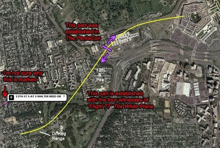 Composite path turns required: one to the left, one to the right.
 PentaCon Smoking Crack version witness bank reports: zero right, one left (perhaps anyways)
White Plane witness bank reports: zero left, zero right.
Completely made up extreme turns to play connect-the-dots? Two. One left, one right.
Estimated wing bank accompanying the right turn according to experienced pilot 'Beachnut'?
"Take a google earth with the yellow path from Pentacon! You then find the radius of turn. From the radius and the speed from the FDR you get the need for something like 80 degrees of bank and 8.7 gs with the wings falling off in a big snap! Just take the radius and speed and look up an aircraft turn equation. Makes the turns required by the CIT to be impossible; as in made up."
---
Additional Discussion at Above Top Secret:
Main thread Craig wouldn't touch
Vs. thread Craig revived as a distraction, where we chatted a bit about bank (pages 3-4).
