Showing posts with label FOIA. Show all posts

Saturday, September 13, 2008

FAA? WTF?

FAA'S NoC ANIMATION
first posting Sept 13 2008, 12 am
Last update 10/8 2am


So, John Farmer is, I guess, back from Arlington and has received reams of new data, this time from the FAA. He alerted Arabesque and I via e-mail.

The FAA has sent me via certified mail all of the records I requested in my Court action. It is going to take the entire weekend to go through it all, but it looks like the ATC audio and radar records for 1332 – 1344 for Washington ARTCC, Dulles, Reagan, Andrews and Baltimore.

If this turns out to be everything I think it is, then CIT is going to be squirming a little more.


I get a lot of these from him and don't even usually keep up. But the second e-mail here, about the included animation, made me sit up and take notice.

I attempted to send you guys the whole video, but it was too big for some mailboxes. You are the first to see this (I hope) and you just know CIT and Rob are gonna love it!

http://www.youtube.com/watch?v=DQsyt_7c1H8


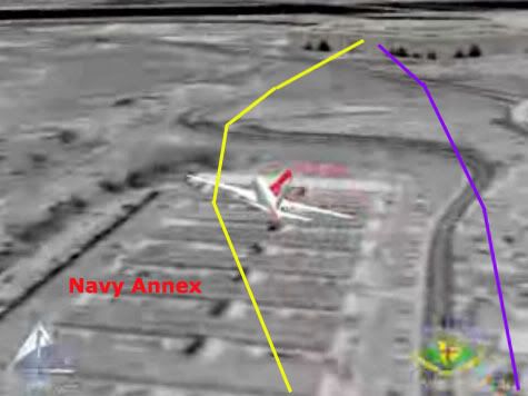
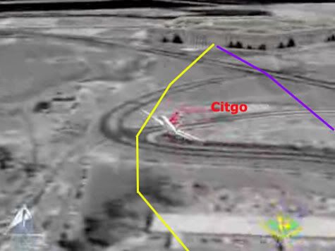
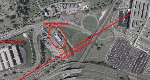
It shows, more or less, CIT's concocted path over the Navy Annex, with a hard hard right bank/turn and a passage north of the citgo, followed by low level impact (higher only to allow the right wing). I have just been in the middle of laying out the overabundance of North-path clues (there should be roughly nil), including the NTSB's earlier animation to similar effect, so this was doubly ironic as it hit me. This is so insane, the easiest explanation I can think of is... Farmer's pulling my leg?

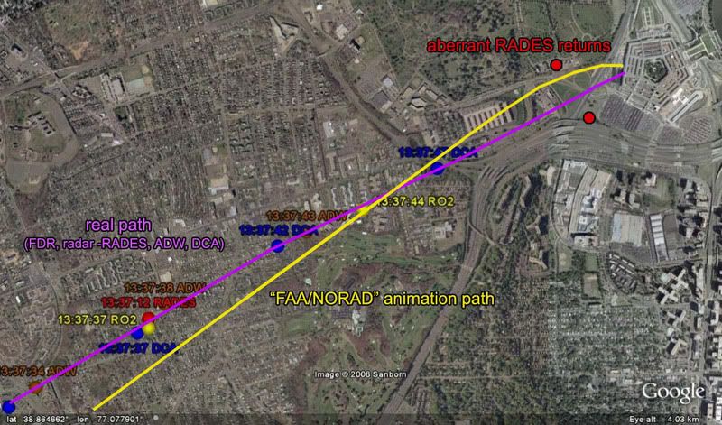
Two stills, with real and CIT paths (quite app) in the usual colors overlaid. These are from the Youtube version, but Farmer made a higher resolution version available for download and viewing.


---first thoughts, unedited
Any thoughts, people? All I can think of is what - the - fuck?

Or, wait... mmmaybe FAA based it on radar and/or FDR up to the end of that data (the loop and all looks fine on first glance) and then stupidly tried to fuse in the NTSB's apparent final moments, hoping they had some reason for putting it on that path for the seconds they were missing (I'd guess 6-10?) ... Just mysteries. This is going to turn out interestingly.
---

Further Developments
Discussion on this took off all over with the expected rapidity, but a more dynamic embrace than some expected.
CIT Forum discussion
Craig and Aldo, who seethe with venom against Farmer, and aren't 'taking the bait' as it were. They speak of "chess moves" and such... Very sophisticated over there, their apprehension and ruminations! On the other hand, many like Rob Balsamo at the PfffT forum were giggling with excitement, while CIT strongly advised caution, leading to a curious argument about which dishonest track to take. CIT messenger Domenick DiMaggio (aka Terrocell, TC329) also started a JREF discussion thread about it, stating at one point:

they faked it and now they're releasing fake evidence to corroborate cit's evidence and yet still try to prove an impact. and as soon as you guys put the cats down and erase lloyd from the history books they can get away with their evil plans.


Whatwhatwhat? Nonetheless, this is where things took off with both confusion and learning. First, beyond disseminating it, the FAA seem to have no role in this short video. JREF member Gumboot first questioned their authenticity and/or their relevance, but over the first couple pages identified the logos onscreen (www.stk.com and HQ NORAD/USSPACE/AN), and found STK was the Satellite Tool Kit Radar module, marketed by Analytical Graphics, Inc. (AGI), a company that makes software for "national security and space professionals for integrated analysis of land, sea, air, and space assets." He noted "the big golf ball things" seemed to be FAA Long Range Radar sites, and decided this may well be "a radar-based map for NORAD purposes," possibly "to determine which radar sites AA77 passed through, so that 84th RADES knew which data to collect for their analysis." Definitely getting somewhere.

Radar based... north path... I would have figure it out eventually, but Celestrin beat me to it. No wonder CIT were apprehensive - they knew about the false return placed for whatever reason, just north of the Citgo, and I had to point out that it wasn't their north path plane, at least 1,000 feet to low for radar to see. Celestrin made the connect:

RADES data has been available for months and it shows the exact same North of Cthulhu poperties as this animation. [...] Why is it such a wonder that an animation, which most likely uses the same data, would also show the plane further north?


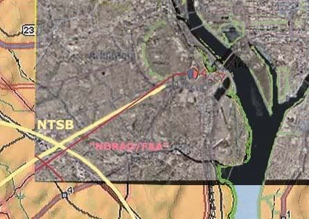
I looked at it a bit the other night and did some graphic comparisons just to see what patterns popped out. I took the peach map from the NTSB's Flight Path Study and set the final map of the animation over it [below]. Note the apparent offset in rotation and location of the loop cross point. I'm not actually sure if the whole path is rotated, or this is just a local distortion from roughness. It is rough and unrealistic in its movements.Farmer instantly pointed out "Look at the loop you idiots, it is a square with rounded corners!" I noticed this too, as did Celestrin. The "squarish" appearance of the turn manuever also suggests that the data, which was used in the animation, wasn't continous." Given 12-second intervals between returns is "too fine for the animation," he wondered "what if one takes the RADES data 1 minute apart," or every fifth radar return, and got this.

When I marked the spots where straight lines start curving, and overlaid it with the 84 RADES returns for the loop, it looks more like this was based on taking every other 84 RADES return (pink dots) as anchor points, and replaced the intervening ones with straight lines or full curves, depending.


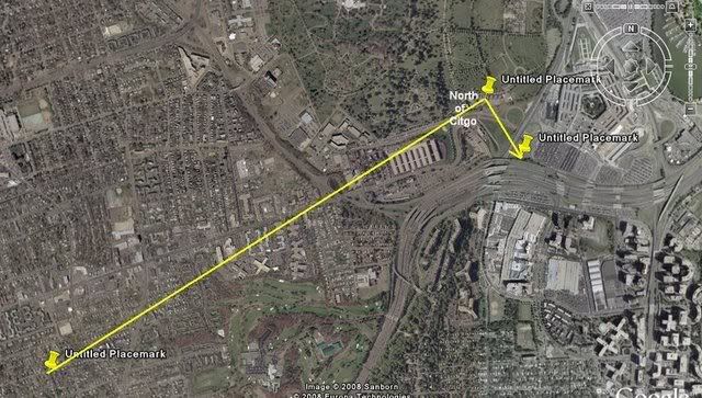
This in turn may be a clue to the north path’s appearance. Consider this pattern in light of these final three points of RADES data (the points stupidly connected above]. There may be a different dynamic at play here, but it seems similar in pattern – draw a straight line to, or near, the north point, and then a sharp curve to try and meet, or orbit, the next aberrant return just south of impact. Considering there may be a rotation of the path relative to the map, or vice-versa, and perhaps a slight spatial offset, the actual mapped curve may not be where it looks to be onscreen. Interestingly, when I rotate the line to fit the real path, the turn is about seven degrees, or the amount the NTSB's final map was rotated from its own lat-long grid. [Propos to Farmer for the background image establishing the real path beyond a reasonable doubt]. This is not my final answer, but I'm pretty sure it's close to correct, or on the right track at least.

---
More on the source
Pilots for 911 Truth forum member "Paranoia" looked at AGI's STK.com website and found some interesting information verifying Gumboot's ID. [link]. Of interest is a winter 2002 presentation by AGI President and CEO Paul Graziani, regarding their 9/11 animations. The accompanying powerpoint presentation confirms he's discussing this very simulation - it's pictured on page 5. In his delivered remarks [PDF link ], Graziani explained to assembled conventioneers how "actual FAA radar data was used to accurately recreate the events and model the flight paths of hijacked airlines as well as the responding military aircraft." Actual data, it would seem so. Accurate, only sorta... Of interest is the line "complex problems that once took weeks or months to complete, now take only seconds or minutes when employing software capabilities." Maybe they should have at least spent hours on this one.

Additional update: Just to clarify, this is a NORAD product, not FAA. This powerpoint presentation, from a June 2002 STK users conference, explains the project a little. It covered all four flights, plus responding fighters, all from FAA-supplied radar data.
---
The Video: I refined slightly the final returns angle, and put it together in video form, viewable with notes here.

Sunday, June 1, 2008

THE FLIGHT DATA RECORDER {masterlist}

A BLACK BOX SURROUNDED BY A MOAT OF MYSTERY
Adam Larson
Caustic Logic / The Frustrating Fraud
last update 8/24/07
Last updated 3/4/08


Much Ado About... Nothing?

Much has been made recently of the reconstruction of data from Flight 77’s Flight Data Recorder, the so-called black box found at the crash scene inside the Pentagon. The "9/11 Truth" analysis of the data is largely based on the fragmentation of the supposedly coherent data in the flight data recorder (FDR) of the attack plane – different versions have appeared, between which different parameters are found to be "altered," leaving each piece neither totally false and dismissable nor totally true and acceptable. Thus they hover in a middle space to be analyzed by experts – primarily Pilots for 9/11 Truth and their expert allies. Predictably, the data as read and shared offers different answers to different questions at different times, depending it seems on the circumstance. The answers consistently challenge the official account, but fail to prvide a rational alternative, and often conflict with each other…

Various aspects of the NTSB animation based partly on the FDR are covered in my three-part video series "That Darn NTSB cartoon," compiled with notes here.

--- About the Sources ---
- The Evidence Trail - NTSB, FBI, 9/11 Commission, and the National Security Archive keeping the data under wraps, and its final revalation to the public in mid-2006.

- The FDR Specialist's Study: A closer look at the verifiably NTSB-provided FDR data.

- The CSV file

- "Three CD's: Where's Snowygrouch's DVD?" The Pilots' Transatlantic animation connection examined. Snowygrouch and the animation's first appearance. NTSB status at the time: unclear IMO, and yet...

--- Analysis ---
- Pilot X and the 440-foot gap: Altitude Questions raised by the NTSB animation

- Created in Translation: the altitude re-set NOT in the animation - where is it then? at FL018... forthcoming

- A somewhat dated but interesting analysis thread by myself and others @ Above Top Secret: Great insights, explanations, obfuscation, and fumbling with appearances by John Lear, John Doe X, and others.

- Ten Degrees From true: THE "NTSB Animation" is Flat Wrong Demonstrating that the north of the Citgo flight path shown is in fact at least 20 degrees off from the Black Box data it's supposed to be based on.

- Final Altitude: Eight Readings: At least four altitudes attributed the the FDR, compared to flyover "witnesses," and the "official story." I did forget radar accounts which place altitude by accounts of it dropping beneath their coverage just before impact. This is said to confirm the official story and probably does.

- 20 Minutes and 20 Miles from True: CSV longitudinal offset

- NTSB animation internal geography {masterlist} My most tedious chapter yet - five posts with one or two more to come.
- A Turn For The Worse: The culmination of the animation studies above: visual proof that the animation's final overlay map is rotated to about the same tune the plane appears north-of-the-Citgo.

- Csv/animation altitude discrepancy. Kind of a mess, mostly intended as a self-correction.

- CSV final plots: Using timeline seconds to determine geographic seconds.

- Missing Seconds: My Last FDR post

- Bank Notes: Draws on FDR bank/roll readings as part of a larger argument

--- My own NTSB FOIA Search ---
- News Coming A half-ass rundown of why I was finally contacting the NTSB.

- NTSB FOIA Response recieved - no discs enclosed

- NTSB's "Goebbels" and Me When I talked to the director - not important but a tad interesting

- Video: That Darn NTSB cartoon part 2 - the Authenticity Sidetrack Snowygrouch et al. and my discless response explained by me in a video.

Monday, May 26, 2008

CMH WITNESS INTERVIEWS

CMH WITNESS INTERVIEWS
Adam Larson / Caustic Logic
The Frustrating Fraud
May 26 2008


This is a belated recognition, and a tip-off for those even more behind than I, of another category of useful new evidence brought to us by researcher John Farmer. The US Army Center of Military History conducted several hundred interviews with military personnel, in 2001 and 2002, about what they experienced and felt regarding the Pentagon attack. Many of these have now been obtained by Farmer through FOIA requests starting late last year. 33 so far are available in scanned PDF and MSWord format at aal77.com, each with a brief description.

These include eyewitnesses to the plane’s attack – where it flew, how it hit, and all that – as well as those who only gathered peripheral clues and who saw and dealt with the aftermath. Some of them are already being buzzed about; they figure into Farmer's more recent findings and are starting to be used in online arguments by myself and others. Notably, NEIT 567 is said by CIT to be a north path flyover witness (a remarkable find for them). She and others are discussed by the team in a thread at their forum, with the usual emphasis on adjectives they like read how they like. They’re ahead of me here; I’ve only looked at a few, but so far they seem to generally fit what happened, and I see little or no cause for alarm or odd speculation.

Farmer is also pursuing another similar avenue; the Navy Historical Center who has their own list of interviews, but so far it seems all he’s gotten is the index of them. From the Navy he also has obtained, available at the previous link, the After Action Report from Port Mortuary, where victim remains were identified. Very relevant to the discussion of who died at the Pentagon and how their remains were identified.

Friday, April 25, 2008

NTSB'S "GOEBBELS" AND ME

NTSB'S "GOEBBELS" AND ME
Adam Larson / Caustic Logic
The Frustrating Fraud
April 24 2008


Previously I have written on my reasons for contacting the NTSB over Flight 77 FDR data, and on the empty envelope I got for my FOIA pains. But for some reason, I never did post the results of the middle part where I contacted the Safety Board’s Public Affairs dep’t. I did mention it once or twice but have never explained in detail or showed the e-mails. I didn’t include it in my FOIA video, which would have made it even more boring. So it came across like a bit of an ambush when I first posted this stuff at Above Top Secret.com the other day after Rob Balsamo/johndoex said:

“This is almost as good as when CL refused to contact the NTSB when he accused us of fabricating the animation.”

He knows damn well that I contacted them if not the full story. Perhaps he thinks I made it all up. But for the record, I’m still surprised how quickly I contacted them, considering what a procrastinator I usually am. I started my first animation/FDR-centered ATS thread on May 27 last year, with my initial well-founded (but ultimately wrong) doubts over the animation’s authenticity. I first found undeniable evidence of NTSB pedigree late on May 29 (Slob’s video posting at Google), and then found more info over the next few days, which had people saying the ball was in my court - time to try it myself.

Even though it’s not my normal thing, I decide to try a unique approach and start with the public affairs department, hoping to score a ‘media liaison’ to help from the inside. It was on the afternoon of June 6th that I called them and talked to a guy named Ted Lopatkiewicz (it’s pronounce lo-pat-ke-wikz, for those who have a hard time), who I later found is the department director, and whom Balsamo has called 'the Joseph Goebbels of the NTSB.' I don’t know why he answered the phone instead of some subordinate, but not even knowing who he was, I got tongue-tied, and followed up with an e-mail at his request. [I considered recording the call, but figured I’d be even more nervous that way, plus I was trying for the human touch as opposed to the legalistic.] Later that night, I filed an online FOIA request for good form and then fired off an e-mail, sent June 7 at 2:37 am. It read as follows:
---
Director Lopatkiewicz

My name is Adam Larson, the guy with the 9/11 questions who spoke with you briefly yesterday afternoon. I’m not sure it’s normal to have reached the director of the office directly, and I’m a bit embarrassed, so right to the point:

I’m sure you’re used to precise questions, but mine are actually many and varied. They regard the flight data recorder from aircraft no. N644AA, American Airlines Flight 77, that of course hit the Pentagon on September 11 2001. I’ve been researching the subject for quite a while, starting as a “conspiracy theorist” looking into what I first thought were silly claims that no plane had hit the building. On closer inspection, I found the claims were even sillier than I thought.

Recently I’ve turned to looking into the Flight Data recorder to see what it can tell us, but have run into widespread confusion. I am fairly conversant with the issues, the publicly available information, like the “Specialist’s Factual Report,” which I have studied closely, and the general outlines of FBI vs. NTSB mandates. My technical questions regard not so much the actual data though as information about the data – questions about information previously released by the NTSB under the Freedom Of Information Act; specific pieces of evidence that have been made public but remain poorly documented. A person who knows the data well would be good to talk to, help me compare files, or anything of that nature, and perhaps you or your office could at least help point me in a fruitful direction.

That is I have definite questions, but first I need to know if this is the office for me. After reviewing the options, I’ve decided it is my best hope. The website explains Public Affairs “Provides […] point-of-contact liaisons for news media representatives.” I’m not exactly news media but am a journalist of sorts in that I run a 'blog and am active in discussion forums and generally respected within my narrow field of focus.

The issue at hand, and the reason I contact you, is that there are some questions about apparently erroneous data attributed back to the NTSB that is causing a lot of confusion in the public at the moment. I believe it’s in the Safety board’s interest to actively help me, and the public, sort this out a little bit. I’m not looking for an explanation, just any additional information that can be had to help shed light on the situation.

I’m also doing what I can through normal FOIA channels, but there is only so much I can actually find out that way, and so am exploring this possibility as well.

I'm sorry if I'm terribly off-base in my request. Thank you for your time and consideration.

Sincerely,

Adam J. Larson
Spokane, WA

---
As Rob and Jeff Hill and others found, they aren't answering questions. The director responded right before lunch the next day, 11:53 am:
---
Mr. Larson:

As I explained to you when you called me yesterday, the National Transportation Safety Board provided technical support to the federal government's investigation into the terrorist attacks on September 11, which was conducted by the Federal Bureau of Investigation. Among the assistance we provided were identification of aircraft parts and read-outs of flight recorders recovered from the Pentagon and Pennsylvania sites (we understand no recorders were recovered from Ground Zero). Because this was not a Safety Board investigation,
it would be improper for us to discuss investigative findings. We did release, under provisions of the Freedom of Information Act, some of the factual information that we provided to the FBI; as you are aware, that information is
available on our website. Any interpretation or explanation of those data would
have to be rendered by the FBI.

Thank you for contacting me, and good luck on your project.

Ted Lopatkiewicz

---
So the NTSB are the ones who made this messed up data, but since they turned it over the FBI, it’s the FBI, who know nothing about how it was rendered, that I’d need to ask. I also recall responding to this letter but don’t seem to have saved it. It was something short and sweet to the effect of ‘thanks for nothing.’ I could have pushed it, but I‘ve seen how much good that’s done others – some fodder for the ‘9/11 truth radio’ shock jocks is all; “listen to that evasiveness in the face of belligerence!” They’re the same with the timid as well I found with my experiment, and being timid, I had double reason not to push it.

Then I just waited and got the same letter everyone else did talking about the same enclosed discs only without the discs, and THEN I just looked at it and figure out the part that most interested me, the north flight path, and proved it was caused only by a grid/map rotation, with no help from either NTSB or PFFFT. All else that seems off with the last frame of data I’m chalking up to last frame recorded thousands of feet away, followed by missing seconds of data, of whatever length makes most sense. That ball is out of my court. So that's the missing chapter in all the detail it's worth or more.

Sunday, September 9, 2007

CITGO VIDEO ANALYSIS

CITGO VIDEO ANALYSIS
(working version posted June 28 2007)
Adam Larson / Caustic Logic
The Frustrating Fraud
Last Updated September 9 late pm


The Nexcom/Citgo gas station was the last real building near 77's flightpath before the Pentagon. Its security video was confiscated by the FBI on September 11 2001 (apparently NOT within minutes of the attack but rather a few hours later). It was held for five years and then released pursuant to FOIA requests on September 15 2006 to Judicial Watch.

The station had multiple cameras multiplexed together onto one screen. Some of the best views were NOT included in this compressed multi-camera screen. Whether this constitutes manipulation/forgery or some more inoccuous explanation I can't say for sure. But it is suspicious, and some of the cameras themselves seem to have been removed since then.


Youtube link: http://www.youtube.com/watch?v=2LJvFjsl6zk&mode=related&search= An analysis of what the remaining low-resolution screens show is in the works. Previously I'd said it showed "more nothing than anything yet," but in fact there are good clues in there. Of special interest are three camera views, mapped out on the model below.

Dual-Pump Camera and the Canopy Flash
Just looking at the view from the "dual pump side" camera (the north end of the station) we see a flash at 4:44 in the video, or 9:40:38 by the video's internal clock (app. set about 3 minutes ahead). The white car there most of the time at the pump is Sgt. Lagasse's. The sequence here: a black and white patrol car pulls in and sends the flash of light, reflected from somewhere else apparently to the south, onto the underside of the canopy, at which point the patrol car speeds away, possibly towards the Pentagon

My video - part 1 of the Citgo analysis, just the canopy flash.

Youtube link: http://www.youtube.com/watch?v=3ChV5gxYfrc#GU5U2spHI_4

Here is a photo of the station's north end - parking, hedges, canopy and pumps - with the Pentagon visible in the background. Compare to the camera view above.
Before getting to angles, I must note that some north-path proponents contend this flash is either from the plane but glancing off the car's roof, or simple sunlight reflected in a flash as the patrol car started rolling (see comments at the Youtube link for my video). It does seem to start inching forward just just a hair early - too subtly it seems to account for a sudden flash, but enough to make this interpretation seem feasible. The angle the light is coming from seems about the same as the angle of natural sunlight at that time, but a different part of the car also catches sunlight a few frames later in a different position. (I intend a fuller anlysis on the timeline of all these events). John Farmer's rebuttal and my counter-rebuttal: link.

However, as I will expand on in this space and with further short videos, there was also a noticable flash of light on the south side of the station a split-second earlier, clearly not reflected from the south side of a car on the north side of the station. There's also employee/customer reactions indicating something happening to the south, and a large shadow also visible on a roadway south of the Pentagon. These will be explained and even if the canopy flash is just sunlight, it somehow seems to show the same thing the other clues do: something other than the sun was sending light to /blocking light from the Citgo, from the south and southeast just before people started gawking towards the Pentagon. A high-speed, low-flying silver AA 757 is one possible culprit for at least one of these clues...

East Entrance (south) View and the Double Flash
This "East Entrance" camera is at the southern edge of the southeast canopy looking back at the store to monitor customers coming and going. Note at left the lightening on the left-hand side, on the narrow east-facing edge of a wall there. This "flash" seen at 9:40:37 is longer in duration than the one off the patrol car half-a-second later, and perhaps better described as a "double-pulse." In slow-motion (video coming) there is an intial pulse just before the canopy flash, which washes in top-to-bottom and fades just as another pulse of light blankets the spot and then fades. Duration: unsure at the moment but seems to be about one second. The light source is roughlly to the east, and could be from either a plane heading from the north or the south.


Below is the video of this flash. Sorry for the glitch - it hangs up just before "slow-motion." Maybe I'll re-post it.


The Shadow
Thanks to John Farmer's interesting work, I can see the shadow now. It's visible in the south-side "Single Pump" camera, and cast on the roadway behind the station (South Joyce Street), divided in two by some invisible obstruction (possibly a median/divider). It appears at 9:40:35 (about 2 seconds before the flashes) by the video's clock and remains for about 8 frames, 1/4 of a second (though it appears stationary, apparently a still frame taken at 4 fps). All-in;all it's a large shadow. A 757 is one possibility.

I know this is crap quality to be blowing it up so big, but hey,
it's there. It can be (roughly) measured.
Youtube link: http://www.youtube.com/watch?v=hF-GcL8hR68

General Thoughts
Quotes from north path/no plane supporters: would these researchers talk about this key evidence like this if they thought it supported their theory or was irrelevant? (most from the inital Loose Change thread spurred by Russell Pickering's analysis)
John Doe X: "Talk about chasing shadows...lol." link
Aldo Marquis/Merc: "I believe the Citgo video was released SPECIFICALLY because of the Citgo witness and his account. I no longer believe this as a possibility, but as an unforunate reality. A counter chess move if you will. [...] This is a clever trick in response to the Citgo employee's account. Simply more bad video with a few editing/graphic/lighting tricks, just like the others." link
Undertow: "You know, I started to analyze that flash 4:44 (mov time) but it's just worthless in all its pixelated compressed crappyness. I don't know what anyone can possible get out of this video besides a migrane." link
(John Farmer's quote removed - I'm not so sure now he belongs on this list)
Craig Ranke (Lyte Trip): "No serious 9/11 researcher would take this video at face value. It makes zero sense." link
Craig Ranke to me: "Evidence tampering is a Federal offense and if you insist on supporting this dubious data that is supplied from the very individuals that you accuse of this crime you are just as guilty as they are." link

So naysayers aside, and all concerns of legitimacy vs. fakery taken into account (the grain of salt one must take this with), the analysis continues.

Saturday, August 4, 2007

THE CSV FILE

THE CSV FILE
Adam Larson / Caustic Logic
The Frustrating Fraud
August 4 2007
rough draft


Released by the NTSB via FOIA request to Pilots for 9/11 Truth member Undertow in August 2006, the “csv file” is one of the more widely-cited sources of Flight 77 FDR information. It’s a huge file – offered by the Pilots for download:

The CSV file, AAL77_tabular.csv (zipped): dowload link

A text list of the parameters plotted: dowload link

It’s a bitch to read. I had initially only been able to open the file as simple text file, with well over 300 values (I stopped counting) each represented in packed clusters for each second of the hour-and-a-half doomed flight, a total of nearly 4,700 frames. A single frame looks like this (highlighted in red is the data for the first frame at 8:19:00 am - the last frame is 9:37:44, ending as the animation does one second early):


Opening it in Excel, once I figured that out, helped little, as it doesn’t really organize the data into readable columns.


Each comma separates one of the myriad values from the next (hence the file type CSV, or “comma separated value”). Many many of them, where there are commas in a row, are blank or inoperative; the NTSB’s SFRI noted that even though “the recorder operated normally,” that report, and the CSV as well, included “only validated parameters.” The blank values, including the radio altimeter, “either were not recorded properly or were not confirmed to have been recorded properly.”

Most remain readable, but with so many values presented this way, the only way I can find anything is to have a good guess of the value I’m looking for (29.92, latitude, etc.) and do a search ‘till I find it. Out of this mess and my relative ignorance (and sporadic, stumbling tenacity), I’ve been able to verify a few oddities proposed by Undertow and his cohorts at P49T: the pressure altitude reset said to place the plane too high for impact, and the 20-mile longitudinal offset, which seems odd but irrelevant.
- I had misread the initial pressure altitude recorded and concluded the csv and animation altitudes in fact matched at the beginning, which they don't. Initial altitude reading: 40 ft msl, 250 feet underground at Dulles, 260 below the animation readout. A mess of a post... and a graph
- The numbers in the tabular csv file match the official story's flight path in latitude/longitude plots (once corrected) and timeline. Nothing new but another verification and a nifty new graphic.
- There seems to be a slight north offset as well, depending on if I'm reading this right. At any rate, the graphing of the csv final plots that helped me see this is interesting for its own reasons.

Thursday, June 21, 2007

NTSB FOIA RESPONSE LETTER RECEIVED

NTSB FOIA RESPONSE LETTER RECEIVED
NO DISCS ENCLOSED!
Adam Larson/Caustic Logic
The Frustrating Fraud
June 21 2007
Updated 6/26


[Note: This investigation is done under terms of the Freedom of Information Act, requesting documents from the National Transportation Safety Board (NTSB). I was spurrred to it by my suspicions over previous FOIA-obtained NTSB data published by Pilots for 911 Truth. ]

Before I even went the normal FOIA route, I first tried a different strategy, contacting the Public Affairs Department. This effort proved interesting but came to naught. I will write a post about that soon. I followed this up with a Freedom of Information Act request via the online form at the NTSB site:

I am lodging a request for items regarding aircraft no. N644AA American Airlines Flight 77 that crashed on September 11 2001. Items I would like to have sent to me:

1) any and all animations/reconstructions of the FDR data from Flight 77
- a working copy that others have received, including a erroneously-labeled time stamp. (this is available online for visual reference)
- If possible any other animations, like the one presented by the 9/11 Commission in a mid-2004 presentation, aired on C-Span, but for which I can find no information. If this was NTSB-produced and is releasable it would be very useful.

2) electronic attachments listed for the Specialist's Factual report (doc ID DCA01MAO64)
- DCA01MAO64_tabular.csv
- D226A101-3G.pdf
- 757-3b_1.txt

3) Other files:
- AAL77_tabular.csv (if different from CSV listed above)
- Original L3 compressed raw AA77 FDR file


I had despaired on reading "turnaround could range from 3 weeks to 1 year or more," as I filed my request on June 7. The response is dated June 12. It was put in my mailbox on the 15th or 16th while I was out of town and I found it on Sunday the 17th. This swift response paralled two other members at Above Top Secret.com, as well as John Farmer’s receipt at around the same time. Here is the letter I recieved [ny name is redacted here even though it’s on the article header on the off-chance this jpeg gets re-posted all over – my street address is also not something everyone needs to know].

It looks like pretty much the same thing everyone else has been getting, as Rob Balsamo (John Doe X) said I'd get if I asked. The same officer that signed Undertow’s and Snowygrouch’s letters, Melba D. Moye, the same wording, the more recent apology for the wrong time stamp, etc. Sound like the one I’m looking for. It informed me of my recent query, and stated “enclosed is the information you requested on a CD-ROM and a data DVD.” At the bottom are the words “enclosures: tpc,” whatever exactly that means.

So what's on the discs? I don't know. They weren't enclosed. The letter was folded in thirds, placed in a letter-size 8.5x3.75" envelope with nothing else. The envelope was not moisture sealed but secured with clear tape. My address was handwritten, and it had a proper looking address with the warning “official business penalty for private use $300.00” and a handwritten code C10-40 (FOIA).
I guessed maybe "enclosed" means in the mail, and started presuming I'd soon have my own copy of the green and purple cartoon with the wrong altitude, wrong lat/long plot, and wrong final bearing that Pilots for 911 Truth and others have been wondering over. But now it seems it’ll be slow in coming, and I’ll have to write in to get this figured out; “In the even that you perceive this response as a denial of some aspect of your request, you may appeal this response by writing” to the NTSB’s managing director Joseph Osterman. They’re all gonna know me real well down there before all this is done.

So while the animation’s direct link to the NTSB remains to be totally verified on my end, the letter sure looks like part of the overall pattern reported so far by FOIA recipients, and it appears I was probably in error for doubting the animation's NTSB pedigree. But strangely, I've been singled out for this silent treatment, some set of factors witholding total confirmation...

Friday, May 25, 2007

FDR 1: THE EVIDENCE TRAIL

FDR 1: THE EVIDENCE TRAIL
Adam Larson / Caustic Logic
The Frustrating Fraud
Updated 5/23/07


Researchers curious about the Flight data recorder from the Pentagon attack plane, from 9/11 to mid-2006 anyway, were frustrated by an uncooperative government. The National Transporatation Safety Board (NTSB) Web site announced “the terrorist attacks of September 11, 2001 are under the jurisdiction of the Federal Bureau of Investigation. The Safety Board provided requested technical assistance to the FBI, and any material generated by the NTSB is under the control of the FBI. The Safety Board does not plan to issue a report or open a public docket." The FBI of course released nothing as its PENTTBOM investigation ground on, and so the data the NTSB had gleaned remained behind closed doors for years.

The data did form a partial basis of the 9/11 Commission’s work. The path for Flight 77 the Commission published in mid-2004 was based on this, not that they ever explicitly said so, and reflected the official story. Oddly, the Commission never mentioned anything about Flight Data Recorder from any flight but 93, neither confirming nor denying the existence of the other three in its Final Report, even in the footnotes.

FOIA lawsuits for the entire NTSB record of 9/11 planes were finally successful in the wake of the Moussaoui trial’s conclusion in mid-2006. The National Security Archive at George Washington University announced on august 11 “the documents were released in their entirety to the National Security Archive and were received directly from the NTSB.” The “entire” catalog of info posted online at the Archive’ site that day included three types of reports:

1) Air Traffic Control recording logs: presented for all four flights
2) Flight path and altitude studies for flights 11, 175, and 77, the first two with complete paths and altitudes based on radar returns, 77’s path partially drawn-in due to a radar gap, but showing the final grand loop over Washington, as seen on Dulles radar, over a topographic map in close detail.
3) A detailed report on the Flight Data Recorder of Flight 93.

Regarding the third category of one, the archive’s announcement read in part: “in addition to the Flight Path Studies and Air Traffic Control Recording transcripts, the NTSB released a February 2002 “specialist’s factual report of investigation” on United Airlines Flight 93 based on the flight's recovered digital data recorder.” Since its cockpit Voice Recorder, the only one recovered and readable, is still under wraps, this clearly means the FDR. “According to the report, the flight recorder functioned normally,” and provided investigator with “graphic analysis of the data recovered from Flight 93.” But oddly, this release made a claim I’ve never heard explicitly elsewhere: Flight 93’s was “the only surviving recorder from the hijacked planes on 9/11.”

Wow! I knew the Black Boxes and CVRs in New York, while three of four were allegedly found but were buried and never admitted to having survived. But I had always heard that the Black Boxes were found at both Shanksville and at the Pentagon and had yielded data in both cases. But after seeing this and seeing no mention of such a study in the 9/11 commission’s report, it almost seems reasonable to ask if the FDR even survived at all.

But of course that’s not where it stands, and this is clearly just a mistake, perhaps by an intern asked to write up apiece beyond her understanding, taking Flight 77’s FDR study not being included as a sign it didn’t have one. That still doesn’t explain [i]why[/i] it wasn’t included, of course, and it is still telling.

The evidence of the recorder surviving is thick enough. Just after the 9/11 attacks, the FBI took over the crime scene, and brought in the NTSB to help locate plane parts and especially the black boxes. By about 4:00 am on September 14, the cockpit voice recorder and the FDR were found, according to CNN and other sources. According to the ASCE's Pentagon building performance Report, the FDR at least was found near the end of the plane's trajectory in ring C (see above). The recorders were turned over to the NTSB laboratory in Washington that same day, where technicians set to summoning the data within. The CVR was found to be useless, and so we had no audio directly from inside the plane, but on the 15th FBI Diretor Mueller said useful information was gleaned from the data recorder.

The 9/11 Commission had referenced this data indirectly, via the NTSB flight path study. As with the same for Flights 11 and 175, it included an altitude mapping, but while those were based on radar returns (with no FDRs “found”), flight 77’s altitude chart is listed as a readin from the FDR. Finally, I just found, the NTSB does have a site for downloading the once-elusive Specialist's Study for Flight 77 in PDF format: "Frequently Requested Items." That's one part of the story made less mysterious. [direct PDF download link]

Back to FDR Masterlist

Tuesday, April 10, 2007

PILOT X AND THE 440 FOOT GAP

FLIGHT 77 ALTITUDE QUESTIONS
Adam Larson
Caustic Logic / The Frustrating Fraud
April 9 2007
last edited 4/15 @ 9:32 pm


In mid-2006, new doubts about the five-year-old Pentagon attack were found, built right into a government-produced animated flight path of AA Flight 77. The group Pilots For 9/11 Truth (P49T) have been able to capitalize on the inherent contradictions in this CG cartoon - most notably in their January 2007 video Pandora’s Black Box Chapter Two - to somewhat convincingly suggest an entirely new flight path that in different (and often contradictory) ways, disproved the official flight path and, if correct, make the plane’s impact a steep improbability. [I'm working on more detailed posts about both sources and discrepancies]. The latitudinal aspect of the new 757 denial trajectory, the apparent flight well to the north of the official path, is one anomaly in this animation, but will be covered elsewhere. Here we’ll focus on the altitude questions, which are, no pun intended, a little over my head and the heads of others, a fact that at least one side in the debate seems to be using to its advantage.

The animated video file was based on the flight data recorder (FDR) of the doomed 757, rendered by the National Transportation Safety Board (NTSB), and released in mid-August 2006 via a FOIA request by a P49T-affiliated researcher. By August 20, P49T co-founder Rob Balsamo (aka John Doe X) had come into possession of the damning flight simulation and wrote about it at the group’s site. The final frame was key: it shows the animation stopping abruptly, as the original data supposedly did, with the plane on-screen still hundreds of feet away from the Pentagon and still far above it. Time at this location: 9:37:44, the second before the plane is supposed to have hit the building. While at that very second the CCTV camera north of the attack path was snapping a plane cruising in about five feet off the ground, the onscreen altimeter reads 180 feet. The plane in this animation could not have hit the Pentagon, at least not at the official time. It would have been several seconds late by the speed and descent rate up to that point. But it cuts there, at about the right time but quite the wrong place, and we were thus prevented a glimpse of the fly-over, the secret landing, and the safe removal of the FDR to be planted back at the Pentagon. (??) These are the gaps we must fill in to reach the "Truth."


Screenshot of the final frame: The time is ajusted to GMT, not EDT, so 13:37:44 should read as 9:37:44. The resolution here is easier to read than in the low-res video of the final maneuver available for free viewing online here

Balsamo explains: “You will notice in the right margin the altitude of the aircraft on the middle instrument. It shows 180 feet. This altitude has been determined to reflect Pressure altitude as set by 29.92 inHg on the Altimeter. The actual local pressure for DCA at impact time was 30.22 inHg. The error for this discrepancy is 300 feet. Meaning, the actual aircraft altitude was 300 feet higher than indicated at that moment in time. Which means aircraft altitude was 480 feet above sea level.” [1] This is also 440 feet above the ground. Thus “the 5 frames of video captured by the parking gate cam is in direct conflict with the Aircraft Flight Data Recorder information released by the NTSB.” [2]

As John Doe X, Balsamo has put together several long – and lonely - posts explaining this true altitude conclusion at the Pilots’ site, and apparently has been pretty aggressive in promoting and defending it elsewhere. [3] I haven’t been able to independently verify his 300-foot correction, but initially guessed it was quite possibly correct. Either way, there is a re-set protocol; from what I gather of the reason behind this, FAA regulations mandate pilots use local atmospheric pressure settings when in the lower, more crowded airspace – below 18,000 feet (FL180). Above that point they re-set to a baseline pressure setting of 29.92. On its ascent, we're told, both the animation and the other data show Flight 77’s altimeter re-set from local pressure (30.21) to 29.92 at about 8:28 am). Pandora’s Black Box shows an altitude drop at that point from 18273 to 18058, a difference of 215 feet; so a rise of perhaps 300 feet when switching back to a nearly-same presure setting on the descent seems plausible, but the corresponding, FAA-mandated re-set is not shown in the animation, and hence the cover-up.

This may not seem surprising – why would Balsamo suspect there should be such a re-set despite the change of control from FAA-certified pilot to suicide hijacker? The reason he has a problem here, and really its own problem, is the other P49T data, also obtained separately by FOIA request, indeed did show the re-set from 29.92 to 30.23. Balsamo summed up the non-animated data “show[s] the altimeter being set in the baro cor column on the descent through [18,000 feet].” [4] I’ve checked and it does. Taking that as truth, the Pilot(s) asked the government why “the animation altimeter does not show it being set?” The question was rhetorical; the answer they had already decided on was that the omission was to make a strike look somewhat less impossible; “this is a blatant cover-up to confuse the average layman in hopes no one would adjust for local pressure to get True Altitude. Too bad for them we caught it.” [5]

A member at JREF named “Anti-Sophist” who describes himself as an Air Force trained flight data expert and electrical engineer, summed up of "JDX"s 300-foot correction “if his true altitude number is correct, he is actually on to something, […but…] No one seems to agree with his "true altitude" calculation except for him.” [6] To see what effect the "cover-up" had, and to help clear up which impossible altitude seemed more likely, I looked into the Pilots’ comparative data, a CSV file for Excel, called AAL77_Tabular, where the pressure re-sets at 18,000 feet are recorded each way. This document forms the basis of my FL018 research (thread coming), but I have yet not been able to independently verify its authenticity. Oddly enough, the recorded altitude does not change at all with the adjustment and there is no meaningful discrepancy!

Ascent:
time - Hg - alt
8:27:58 30.21 17938
------------------------------ FL180
8:28:00 - 29.91 - 18015
8:28:02 - 30.21 - 18093
8:28:04 - 29.91 - 18170
8:28:06 - 29.94 - 18247
8:28:08 - 29.91 - 18324
8:28:10 - 29.92 - 18402
8:28:12 - 29.91 - 18483

Descent:
time - Hg - alt
9:24:12 - 29.91 - 18205
9:24:14 - 29.92 - 18126
9:24:16 - 30.23 - 18049
------------------------------ FL180
9:24:18 - 30.01 - 17972
9:24:20 - 30.23 - 17895

The pressure was reset at 8:28, with no 300-foot drop in altitude, and re-set on descent, again with no effect. Yet it shows essentially what the "altered" animation shows at termination: 173 feet compared to its 180. [7] So the data here shows two pressure re-sets, 302 feet at takeoff, 173 at the end. The animation shows 300 at takeoff, ONE reset, and 180 at the end. The pilots insist the data and animation match except for "the blatant cover-up" of neglecting the second re-set, turning the data's real alt of 480-ish to 180. But in reality, the animation and this CSV file match from A to Z despite the alleged cover-up and that extra 300 feet is looking like a red herring.

But even without Pilot X’s "correction," a Pentagon attack could not have occurred by a plane that far from the building, and that high, by either the CSV file or the animation. Considering this animation also shows the northern flight path that rules out this plane reaching either the Pentagon or the light poles before it, a whole slew of glitches, or perhaps some other explanation, would be required to debunk this damning NTSB-supplied animation.

One interesting tack is to compare all available sources, check their degrees of authenticity/verifiability, and then compare which comport with which and, as Sesame Street used to urge us, find “which one of these things just doesn’t belong.” There is an investigation of this underway, going very slow so far but it should be up soon.


Sources:
[1], [2] Flight Data Recorder Analysis - Last Second of Data - 09:37:44 08/20/06 http://pilotsfor911truth.org/pentagon.html
[3] John Doe X. Fdr Vertical Speed, Altimeter lag issues addressed as well. Pilots for 9/11 Truth forum: Flight Number: American 77. Posted October 15 2006, 08:41 AM http://z9.invisionfree.com/Pilots_For_Truth/index.php?showtopic=106&st=0&
[4], [5] Questions for the US Govt regarding AA77 Flight Data Recorder. Posting date unlisted
http://pilotsfor911truth.org/pentagon.html
[6] “AA77 FDR Data, Explained.” Posted by: Anti-Sophist. October 13 2006at 9:10 pm. http://forums.randi.org/showthread.php?t=66047
[7] AAL77_Tab - Excel document - downloaded from: http://z9.invisionfree.com/Pilots_For_Truth/index.php?showtopic=64&st=0&

Tuesday, March 27, 2007

THE FOIA WARS

FARRELL VS DOD VS BINGHAM VS DOJ
IN SEARCH OF THE HIDDEN VIDEOS
Adam Larson
Caustic Logic/The Frustrating Fraud
December 17 2006


Enter Judicial Watch (JW), a conservative/libertarian grouping of lawyers who target government/judicial/legal corruption. They’ve been harsh on the Clintons and their various scandals, and were instrumental in House of Representatives impeachment efforts in the 1990s. But they have also proven willing to tackle the Bush administration to some extent – after all they’re supposed to be watchdogs. Representing FBI special agent Robert Wright, Judicial Watch charges pre 9/11 incompetence at the FBI’s counter-terrorism division (over both the Clinton and Bush years, from Freeh to Mueller). Most pointedly, they summed up that Wright “accuses the FBI of obstructing investigative efforts that might have prevented some of the September 11 attacks.” [1] Although it apparently wasn’t intended to such ends, the lawsuit has been used by many as evidence of a LIHOP theory of the attacks based in the dubious line that “softness” on “the Saudis” was to blame.

Now Judicial Watch is making moves towards pulling a leading leg from beneath the MIHOP no-plane-at-the-Pentagon crowd. In February 2006 they filed a lawsuit against Alberto Gonzales’ Justice Department to release some video of the attack captured by Pentagon cameras. They have also announced plans to sue the FBI to release the 84 videos from surrounding cameras seized and kept under wraps. “Our experience has been that whenever the government takes extraordinary measures to keep the lid on documents,” their announcement of intent read, “it is worth investigating.” [2] JW clarified they were seeking video release “in part to help put to rest conspiracy theories that a government drone or missile hit the Pentagon,” clearly something the government should be eager to cooperate with. [3] Earlier JW suits to this end had been denied, with the government saying they needed to keep the tapes secret on account of the pending trial of Zaccarias Moussaoui.

Whatever logic there may have been in that refusal, it fell flat after the trial’s conclusion in early May 2006. On May 16, Judicial Watch posted the first two videos handed over to them by the Justice Department - one of them is simply the video from the Pentagon's security cameras from which the five stills were extracted in 2002, and the video is no better than the stills. The other was from a camera just a few inches away at the same checkpoint, and equally worthless as evidence for either side. These were not much, but were hoped to be the first in a series of releases. [4] This was big news on May 16; JW President Tom Fitton was interviewed by Bill O’Reilly in his “Impact Segment:” Fitton explained “we wanted to help put to rest conspiracy theories out there that were suggesting that a cruise missile hit the Pentagon, that the government murdered the passengers on Flight 77, and other outrageous stuff. Just having the videos released is one more leg of the conspiracy theory that has been knocked out. This also reminds Americans of the evil we are facing.” [5] Fox News in general also ran the story [6] along with several wire services. Fitton was quoted in a May 16 CNN story as saying “we fought hard to obtain this video because we felt that it was very important to complete the public record with respect to the terrorist attacks of September 11.” [7]

Despite the watchdog group’s public relations coup, there is in fact some contention over who is responsible for these releases. Scott Bingham, administrator of the site Flight77.info, claims it was he, not Judicial Watch, that “forced the release of the recent flight 77 video.” He pointed to his FOIA lawsuit, Scott Bingham vs. DoJ et al., with Bingham posting letters sent to the DoJ and responses sent to his attorney Scott Hode. The reason for the request was summed up by the department: “tired of what plaintiff’s complaint calls “outlandish conspiracy theories” about the crash […] plaintiff seeks to correct what he describes as a veritable culture of misinformation.” Their opinion, issued August 1 2005, was that “this information should not be released until the risk to the Moussaoui prosecution has passed. Defendant therefore seeks summary judgment in favor of its assertion of Exepmtion 7(A) and dismissal of plaintiff’s lawsuit with prejudice.” [8] Perhaps it’s no coincidence, but unlike JW, Bingham is a 9/11 Truther, just one fed up with the Fraudsters. He seems to believe neither Loose Change nor the government.

The judge agreed to the exemption and and blocked the release, but as the Moussaoui case was decided, on May 5, Judge Friedman set a deadline date of May 26th, giving the government three weeks to either let the videos go or “show cause” to hold them longer. Bingham explains it was this date, not JW’s actions, that got them released in May. [9] According to a timeline of all this litigation, Bingham was indeed well ahead of JW. (thanks to Jim Hoffman at 9-11 Research for compiling this). It was back on October 14, 2004 that Scott Hodes, on behalf of Bingham, sent a Freedom of Information Act request to David Hardy of the FBI for any videos “that may have captured the impact of Flight 77 into the Pentagon.” On November 3: The FBI replies that their search “revealed no record responsive to your FOIA request,” and on the 17th Hodes appealed, citing evidence that the videotapes indeed did exist. [10]

Finally on December 15 Judicial Watch’s Director of Investigations & Research Chris Farrrell first asks for the same videos. Farrell’s request bypassed the DoJ and instead was put on a fast track via the Defense Department, though the request covered files from the FBI and Homeland Security as well. Both Hodes and Farrell received early-2005 responses that the evidence needed to be kept secret to protect ongoing legal cases. On September 9, 2005, a FBI Counterterrorism special agent filed a declaration admitting to 85 videotapes in the FBI's possession that were “potentially responsive” to Hodes’ and Bingham’s request; the agent further declared that she watched 29 of them before she found one that actually showed the impact. On September 26, Hodes filed a request seeking all 85 videos. [11]

On February 22, 2006 Judicial Watch filed a further lawsuit against the DoD for its refusal to release the videos, and on May 16 they finally obtained them, although the actual handover was by the Justice Department. They immediately posted the clips on the Judicial Watch website. Hoffman noted “the site is down for about half of the day due to demand” for the brand new footage. The high-profile lawyers thus were able to break the story first despite entering the race late and thus eclipsed Bingham and his site which, unlike JW, seeks to prove a MIHOP scenario with remote controlled airliners. It seems possible Rumsfeld and his lawyers helped JW steal Bingham’s thunder by approving the video first to Farrell - indicating that their days of letting secrecy feed the wing nuts were perhaps nearing an end.

Disc sent by Hardy at FBI to Hodes and Bingham, 3/16/06

Yet back on March 16, exactly two months earlier, David M. Hardy, section Chief of Records/Information dissemination at the FBI sent Hodes a disc with the same two time lapse videos later received by JW, labeled with a fancy cursive font “Flight 77 CD-ROM”. Bingham seems not to have posted them at this time – or if he did it seemed to generate no buzz. The first news my internet searches are showing was on and after May 16. On the 17th, Alex Jones’ Infowars site did a piece on the videos that mentioned the Bingham case, but this seems to be the biggest story on Bingham’s pivotal role, which remains absent from the mainstream news.

sources:
[1] Klayman, Larry, Chairman, Judicial Watch Schippers, David, Counsel, Schippers and Bailey, Judicial Watch. Wright, Robert, Special Agent, Federal Bureau of Investigation. “Judicial Watch News Conference: FBI Whistle-Blower.” May 30 2002. National Press Club, Washington, D.C. http://www.infowars.com/jw_transcript.htm
[2] Judicial Watch Files Lawsuit Against Defense Department for Withholding Video of 9/11 Attack on PentagonDOD has "no legal basis" to refuse release of videotapeMarch 1 2006http://www.judicialwatch.org/5724.shtml
[3] See [2].
[4] “First video of Pentagon 9/11 attack released: Watchdog group says video will end 'conspiracy theories.'” CNN. May 16, 2006. http://www.cnn.com/2006/US/05/16/pentagon.video/index.html
[5] The O’Reilly Factor Flash. Tuesday, May 16 2006. http://www.billoreilly.com/show?action=viewTVShow&showID=807
[6] "Pentagon releases video of plane Hitting Building on 9/11" Fox News. May 16 2006. http://www.foxnews.com/story/0,2933,195702,00.html (Conspiracy theorists may or may not be disappointed Tuesday when they see footage released from the Pentagon showing two angles of American Flight 77 hitting the western wall of the building on Sept. 11, 2001...)
[7] See [4].
[8] Case 1:05-cv-00475-PLF Document 13 page 5 of 23. Filed 08/01/05. Accessed November 8 2006 at: http://www.flight77.info/documents.htm
[9] Accessed November 8 2006 at: www.flight77.info
[10] Hoffman, Jim. “Pentagon Attack Footage: The Suppression of Video Footage of the Pentagon Attack.” http://911research.wtc7.net/pentagon/evidence/footage.html
[11] See [10].
[12] See [10].
[13] Accessed November 8 2006 at: www.flight77.info
[14] Watson, Steve. “FBI Withholding 84 More Tapes of Pentagon on 9/11: Magically Only 1 shows impact so why not release the rest?” Infowars. May 17 2006. http://infowars.net/articles/may2006/170506Pentagon_videos.htm