Showing posts with label John Doe X. Show all posts

Friday, April 11, 2008

A CHERRY PIE FROM ROB’S ORCHARD

A CHERRY PIE FROM ROB’S ORCHARD
Adam Larson / Caustic Logic
The Frustrating Fraud
April 10 2008
last updates 4/16


Picking?
My recent Youtube video That Darn NTSB cartoon, part 1, featured Rob Balsamo/Johndoex vocally promoting north path ‘data’ supposedly from Flight 77’s black box and ‘corroborated by Pentagon police officers…” I was explaining the issue and working up to a video explaining my previous findings that the ‘north plot data’ was just an illusion created by turning the final map the wrong way, which I had always taken him as denying. Balsamo left a comment: ”lol... this has to be the worst case of cherry picking i have ever seen. Bravo CL, you have out done yourself.”

I responded “if I'm picking cherries that implies I'm ignoring things. Regarding my analysis of the FDR north path, using YOUR OWN words, what am I ignoring? The actual 'north plot data?' Or what?” His explanation was interesting, “CL, we have been saying the "map may be rotated" since Aug 2006.” I didn’t recall that ever seeing them say anything like that, but spurred by this comment, I did look around a bit and am left asking “Cherry picking? What else should a cherry-hungering blogger do when he finds himself in a friggin’ cherry orchard? Dig around for a raspberry bush?”

Did he or some other member say once, somewhere, the "map may be rotated"? Probably so since he put it in quotes and gave it a date, and they say a lot of things – the question is how, when, where, how often? Is this the impression that comes through? Where can I read/hear these thoughts? “Clearly you don’t remember when I told you the same thing during our first exchange,” he tipped me off. I did miss this first time around, and going back to the passages he likely means here, from my thread at Above Top Secret.com, I see why. I’ll cover this at the end; first the cherries. This is not a perfect sampling by a long-shot, but I have enough cherries for a whole pie. I have less fresh ones than fermented vintage from his earlier activist phase before he was banned everywhere. I was made more familiar along the way with his well-known tactics of appeal to expertise, to their impressive roster, distractions and insults, pretending his opponents are all stupid and lazy, lengthy irrelevant re-posts and links, links, links… Clearly he enjoys being banned, and values true discussion roughly nil.

The Issue: Headings and Rotations
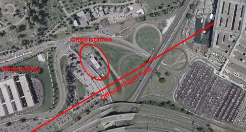
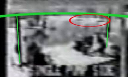
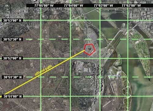
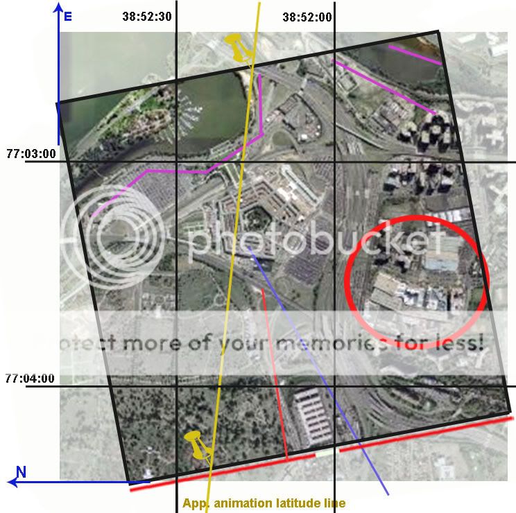
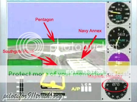
First, to understand the significance of any of this, one must understand somewhat the heading/map issue. The simplest way to explain this is with this on-screen discrepancy – the heading dial (lower right) reads 70, meaning degrees from the magnetic pole, which corresponds with the FDR-recorded heading. Considering magnetic declination in the area at that time of 10.08° this means a path about 60° from the true north pole, which closely matches the physical damage path before and into the Pentagon. To end at impact, a line on this heading would have to pass south of the Navy Annex and Citgo gas station, where the light poles were severed. The path that we see on the screen however passes well north of the Annex, the Citgo, and the poles, on a heading relative to landmarks that has been multiple-verified by everyone as about 78-80° real, so 88-90° magnetic. So in the picture above, the heading dial and the visual path do not match; one of them must be wrong. [more info here] Either the ground map is rotated wrong while the plane’s movements are accurate to the data, or the ground clues are accurate to the data with the heading dial and all other data altered to cover this up.

Considering the first option matches the rest of the more raw data, nearly matches the physical damage path (for heading) and as I’ve shown is visually verifiable as being the case to anyone who takes the time, the answer is clear.

The alternative - they altered the data to fool us but forgot to alter one rendering of it – the cartoon, the only version most people could see an understand - is of course worth considering but seems a bit silly. That would be like writing a screenplay, filming the movie, deciding you don’t want people seeing it, re-writing the screenplay, then sending the new screenplay out to theaters while slipping in the original movie that was never re-done. Ready to launch a fledgling Truth group to stardom…

The Orchard
I stand accused of distorting Rob’s claims to make him out as unquestioningly supporting the second hypothesis when, in fact, he’s always remained open-minded on the rotation issue. This is what I found, in chronological order except two dates covered at the end. Remember we're mostly discussing the screen here, the visual animated path and the heading dial. Which has he cast more doubt on?

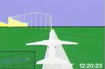
8/24/06, on first posting of the animation’s final maneuver, “About This Video This is the final maneuver performed by the aircraft which hit the Pentagon on September 11, 2001. This animation was provided by the NTSB and is accurate in terms of the flight data recorder on board this aircraft.” No mention or notice yet of the north path aspect which, other than location of the final map, is all that really conflicts. The altitude is about right, which was his point. [source]
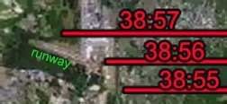
11/28/06, Democratic Underground: “When we first received the animation, i had thought perhaps the NTSB messed up on the graphical presentation as well (we went over this briefly on today's Jack Blood broadcast). However, if you look at the initial phases of flight (particularly the take off), it is lined up perfectly with the taxiways and runway as the aircraft taxi's out for take off. Also, we have further evidence which confirms the flight path.. including witnesses, which will be put together in a report. […] The facts conflict with the official fairy tale. […] the professionals at the NTSB dont make mistakes in terms of magnetic variation (as shown in the initial phases of flight).” [source]
3/27/07 at the Loose Change Forum: “Heading indicator altered to match southern approach... however plot confirms North of Citgo testimony given by Pentagon Police Officers. (Please try not to delete this if you want truth)” [source]
5/9/07 – Micheal Herzog interview, RBN “the NTSB data, the plot, the animation that they plot out, has it on the north side of that Citgo gas station […] The north path that we’ve been trying to get answers for, from the NTSB and FBI, is also corroborated by Pentagon police officers, filmed on location, betting their life on it that it was on that side of the gas station. […] [The PentaCon] corroborates the flight data recorder as far as the flight path being north… I mean, right there, it’s dead to rights, right there that the investigation needs to be opened.”
6/4/07 – first comments at ATS, special treatment below: “The heading (in the little instrument) was altered, to confuse the average layman and to grab suckers to buy the official story and the fact the professionals at the NTSB 'screwed up' in their plot.”
6/7/07: “Fact - The NTSB plotted the aircraft north of the govt story flight path” [source]
6/8/07 more at ATS.com, as with 6/4, see below: he mentions that at one point, “i had thought the NTSB may have screwed up a bit and rotated the map a bit.
7/31/07 e-mail: “Im not trying to sound derrogotory here, but do you happen to have a learning disorder? […] as a side note, the map isnt rotated, and the heading in the csv file does not line up with the physical damage.”
8/3/07 e-mail: Q: You're sure the final map isn't rotated relative to the background lines? A: “Put Google Earth into the same perspective as NTSB animation map with grid lines (you satisfied yet that the animation is from the NTSB? lol), lat/long on ground. You will see very little difference in angles.” [wrong - the difference is exactly that seen between the animation path and heading dial - about 17 degrees]
[ahem...]
9/19/07, e-mail: “The map isnt rotated. We are not sure exactly how the NTSB made their plot as they are refusing to answer any questions. […] The only thing that doesnt correspond is the heading in the heading indicator at end of flight in which John Farmer did a great job locating the alterations.” [note: Farmer no longer holds this view (it was a 'first guess') and thinks johndoex is a kook - my words, not his].
9/24/07, Above Top Secret: "I'll let you in on a little secret. It doesnt matter if the map is rotated or not. We are not arguing that fact in the latest 3D animation. [...] The map rotation just isnt that important, especially since we place the aircraft on 61.2 degrees and it still doesnt account for physical damage." [source]
4/?/08: “CL, we have been saying the "map may be rotated" since Aug 2006.”

initial doubts
As the two bolded examples show, johndoex had indeed, at one time, been wiling to entertain the obvious and proven conclusion. As the rest of the text above shows, he quickly stopped believing in it for some reason. As I started my thread at Above Top Secret.com alerting people, clumsily I confess, to the discrepancy that challenged the north path 'data' in late May 2007, Rob weighed in on June 4. I hadn't yet decided the map was rotated, but that was seeming the most likely.

“Havent read this thread... but heres a reply from P4T Co-Founder.” He linked to where he had just explained elsewhere “the headings in the csv file and animation were altered... The NTSB plotted the animation from take off on runway 30 at Dulles to end of recording based on lat/long (see the grid on the ground? See the yellow poles extending from the aircraft to the ground? Yeah.. thats a plot). The heading (in the little instrument) was altered, to confuse the average layman and to grab suckers to buy the official story and the fact the professionals at the NTSB 'screwed up' in their plot.” In other words, the final animation map is the ONLY real clue to heading, not nan error, and so all other data from the dial to the FDR decodes that show the same, were altered. He also summarized “the animation heading (instrument reading) was altered to show a southern approach. If the heading wasnt altered it would show 090 Mag or 080 True. Just as the plot shows to the north of Citgo.”

A few days later on the 8th, he posted for us all a rundown of his thinking on the flight path discrepancy, “in a nut shell, the timeline, files, how they were obtained. the making of small video clips on youtube.. the introduction and reasons why to start questioning the flight path instead of thinking it was an error.. and the making of our film.” They started by deciding the animations truly was NTSB, despite no paper trail, because it matched the other data they put out. After this, they quickly noticed that it didn’t match, which is what made this proven NTSB product so interesting of course.

“We noticed the flight path right away that it was off in the animation. We didnt pursue it initially because i had thought the NTSB may have screwed up a bit and rotated the map a bit. So we proceeded with altitude and the like... remember.. its late august 2006. Then i made a video regarding the final maneuver and lack of intercept... you probably seen it.. many have. .Dated Aug 24, 2006. (note, we arent even worried about the flight path at this point because we think the map is rotated) […] meanwhile.. Craig and Aldo were working on their research. .went to DC.. etc. They came back and said "We have a witness who places the plane North of the Citgo!".. And i said.. well great.. now the flight path goes into the rest of the conflicts with official story.. and a new video was born...”

So that's it. It looked like an error, but some external ‘witnesses’ and all they have to do with data translation issues shifted the analysis of the FDR. Gov't-supplied witnesses that match something that’s likely an error in gov’t-supplied data should raise red flags. Rob sees a red flag and charges. Now the video screen is real and all reality rotated around it. Rob, I’m sure you’ll see this sooner or later; feel free to show me your more reasonable side in action. I'm not listening to any more interviews or registering for your forum just to fish for quotes. But this sampling here don’t look too good. You tacitly and indirectly admit now that the map is probably just rotated, and point out that you suspected that at first. So what went wrong in between? Hm?
---
updates:
4/12: I forgot to include this line from his comments on my video page:
"Yes, later i had made the statement that the "map is not rotated" via email which you promptly posted on your blog, despite the numerous interviews i have done to the contrary. Think about that.. :-)"
Yeah, I started thinking about that and that's how this post came to be. Mr. Hyde, please quit telling me you're also some reasonable Dr. Jekyl, somewhere, in the interview I can't find, when you've been running around saying shit like that posted above.

4/16: New quote, e-mail Rob sent out a while back to someone else and saw fit to share with me:
"Map rotation is pretty much what we been saying since day 1 and have said on almost every radio and TV interview. We thought the map was rotated when we first got the animation, that is why we worked on [other issues...] The flight path is secondary and [...] the other issues are primary. [...] We did briefly look into the rotation [...] which it appeared the map was not rotated, and eventually were going to look into it more thoroughly. But since CIT has found new witnesses to a DRA (Down The River) approach, i dont think we are going to bother much more with the flight path and leave that up to the people who were there and actually saw it.

[...] we later included the flight path in our "Questions to the US Govt" on our pentagon page because there are many independent north side witnesses (we wouldnt have even bothered with the flight path had there not been any NOC witnesses).

The professionals at the NTSB just dont "rotate" maps by mistake. They do these types of animations on a regular basis. Since there are so many NOC witnesses, perhaps someone (a whistleblower?) at the NTSB rotated the map intentionally to get people looking into a north of citgo approach? Who knows...."
[emph mine - I tend to agree, which is part of why I'm looking into this][source]
The witness-proven east of the river bs thing is not proven at all but what Balsamo is saying here is ALL the FDR data is out the window now - an obvious fake since it doesn't match the witnesses. (who essentially don't exist - one odd, vague guy and some misread other evidence, etc...).

So it was rotated, and probably not on accident. Rob and I seem to be agreeing on this. A backwards mag rotation might make sense, but man what sloppy work. But seven degrees? The JREFfer types will have to think of their own explanations. Step two... hmmm.

Saturday, September 15, 2007

REBUTTAL TO JAMES FETZER

LITMUS TEST FOR RATIONAILTY?
REBUTTAL TO JAMES FETZER
Adam Larson / Caustic Logic
The Frustrating Fraud
June 27 2007
last updated September 15 2007


A new press release boosting Pilots for 9/11 Truth as “driv[ing] another nail into a coffin of lies told the American people by The 9/11 Commission” was just released by Scholars for 9/11 Truth (the Fetzer wing). Co-founder of the recently-divided organization James Fetzer in fact seems to have written up the release, titled “New study from Pilots for 9/11 Truth: No Boeing 757 hit the Pentagon.” It was released on June 21 and picked up by Yahoo news, apparently a bit of an achievement, and has been widely republished since then. It demands a firm, well thought out response from my end, and hence the slight delay in publishing this (and the later edits and updates).

As the public decree explains, the Pilots had petitioned the National Transportation Safety Board (NTSB) under the Freedom of Information Act to receive data from the Black Box (FDR) of Flight 77. Their study of the data, Fetzer announced, “has confirmed the previous findings of Scholars for 9/11 Truth that no Boeing 757 hit the Pentagon on 9/11.” [1] I'm not sure "report" is quite the right word; it's "signed by fifteen professional pilots," so it seems to be their three-month-old March 26 Press Release, which summarized all their AA77 FDR findings. Fetzer sums their points: “the plane was too high to hit lamp posts and would have flown over the Pentagon, not impacted with its ground floor.” So it's not terribly “new,” and what’s even older is the tired list of hollow no-planer reasoning that is his group’s bolstered previous argument.

"We have had four lines of proof that no Boeing 757 hit the building,” he explained, all flawed, well-explained or seriously questioned elsewhere, and too boring to bother re-hashing in detail here; but briefly, 1) the too small hole and “the wrong […] kind and quantity of debris,” 2) the CCTV video that shows something smaller than a 757 he thinks, 3) ground effect, and 4) the unmarked lawn. These four tracks of reasoning prove to Fetzer, “conclusively, in my judgment - that no Boeing 757 hit the building.” Noting the eyewitness accounts of an AA 757 that flew by that way as the “most important evidence to the contrary,” he found that “if the NTSB data is correct, then the Pilot's study shows that a large aircraft headed toward the building but did not impact with it. It swerved off and flew above the Pentagon." [2] Just like others have been theorizing lately. How nicely it all falls together… and the Pilots don’t even have to offer a theory themselves.

Anyway… he wrote the piece with the cooperation of Rob Balsamo (John Doe X, co-founder of Pilots for 911 Truth), who explained elsewhere “Jim Fetzer and myself worked on this together.” Yet the final PR contained a major blunder… Fetzer stated that the Pilots “not only obtained the flight data but created a computer animation to demonstrate what it told them.” [3] What on Earth does that mean? I haven't seen this other animation yet, and had just been in a wrangle with Balsamo for hinting at just that possibility, contrary to their claims. Balsamo had to scramble to clarify their group “did not create the animation, which we included in "Pandora's Back Box". The NTSB provided the animation based upon its own data and spread spread sheets which can be found at our site/forums.” [4]
--
update 8/11: Recently Pilots for Truth did release an animation based on the black box data. It's pretty interesting and well done. Viewable here. Perhaps this is what Fetzer was talking about?
update 9/15: As Rob has pointed out to me, the crossed-out statement above is wrong - based on a misreading. Aplogies to have miseld with this sloppiness. They worked together on the corrections, as is obvious when I look back. In pennance, a gratis link to his unfiltered words.
--
Otherwise Fetzer carefully quotes Balasamo’s vague copy-and-paste master take on their findings: "the information in the NSTB documents does not support, and in some instances factually contradicts, the official government position that American Airlines Flight 77 struck the Pentagon on the morning of September 11, 2001." While it’s more tame than what Fetzer says, he’s not so much putting words in Balsamo’s mouth as – well, here’s another careful quote:

“Pilotsfor911truth.org does not make the claim that "No Boeing 757 hit the Pentagon". We have analyzed the Flight Data Recorder data provided by the NTSB and have shown factual analysis of that data. We do not offer theory.

While we do not make this claim in these words, the analysis we present on the basis of the NTSB's own data factually contradicts the official account that Flight 77 hit the Pentagon--if trends are continued beyond end of data records--and therefore supports the inference that American Airlines Flight 77 did not hit the building based upon that data.”
[5]

In other words, they have only discovered and relayed factual government data that supports the inference that the plane would not have hit. They didn’t say it didn’t hit. They let Fetzer say it for them.

“Don't be taken in by photos showing damage to the second floor or those taken after the upper floors collapsed, which happened 20-30 minutes later," Fetzer warned, and by which I’m not sure what he means. "In fact, debris begins to show up on the completely clean lawn in short order,” and proposed this fake plane debris “might have been dropped from a C-130 that was circling above the Pentagon or placed there by men in suits who were photographed carrying debris with them." [6] Might be…

The most famous such scrap, photographed by Mark Faram, Fetzer admits “is a piece from the fuselage of a commercial airliner, which is frequently adduced as evidence,” by, for example, James Hanson of Ohio. Fetzer explains in his PR that Hanson “has traced that debris to an American Airlines 757 that crashed in a rain forest above Cali, Columbia in 1995.” Check out what this genius Hanson uses for evidence: a six-year old liana vine still embedded in the Pentagon "fuselage" metal! You have to see it to disbelieve it, so DO NOT click that link if you want to believe Hanson. Fetzer bought it though and was impressed enough with this find to offer to republish Hanson’s study on the Scholars’ site. [7]

Fetzer in one of his frequent Fox News appearances (artsified by me)
One of the deepest ironies revealed in Fetzer’s missive is that "Fetzer [...] retired last June after 35 years of teaching courses in logic, critical thinking, and scientific reasoning.” Well, how could one argue with the logical conclusions of a renowned logic expert? I’ll try it caustically. Fact is, what this background of his shows to me is that he knows exactly what he’s doing – elevating a fraud to guiding principle of the “Truth Movement” he claims a leadership role in to arrive at the “truth.” In the end, from all this Fetzer was able to use his deep knowledge of ctical thinking and scientific deduction (as well, of course, as years learning all of their opposites – the arts of sophistry, quackery, and deception) to deduce an argument finally totally inverse to my own growing suspicions:

"The Pentagon has become a kind of litmus test for rationality in the study of 9/11. Those who persist in maintaining that a Boeing 757 hit the building are either unfamiliar with the evidence or cognitively impaired. Unless they want to mislead the American people. The evidence is beyond clear and compelling. It places this issue 'beyond a reasonable doubt'. No Boeing 757 hit the Pentagon."

I am quite familiar with the evidence, and I invite anyone to check my reasoning for soundness of judgment. That’s what this site’s about: “the hijacking of the 9/11 Truth Movement by the no-757 at the Pentagon theory." It almost feels with this salvo like Fetzer the mental “muscle hijacker” is letting us know the pilots have the cockpit; he tells us never mind the doubters, move to the back of the plane. No need to investigate for yourselves, we have it all figured out. We are returning to the airport. We just need to agree on this and move on.

But what if the Pilots intend to crash this plane? It’s happened before. That's not even a box cutter Fetzer's holding, people. It's a carbdoard prop. We can take this plane back. Let's Roll.

Sources:
[1], [2], [3], [6], [7] Fetzer, James/Scholars for 9/11 Truth. “New study from Pilots for 9/11 Truth: No Boeing 757 hit the Pentagon.” June 21 2007.
Trackback URL: http://prweb.com/pingpr.php/Q291cC1NYWduLVRoaXItQ291cC1UaGlyLVplcm8=
http://news.yahoo.com/s/prweb/20070621/bs_prweb/prweb534642_1
[4], [5] John Doe X. Official Comment/corrections. Pilots for 9/11 Truth Discussion Board. Posted Jun 23 2007, 12:36 AM. http://z9.invisionfree.com/Pilots_For_Truth/index.php?s=ec3b737719855ae19fc27c1b5a81c7b0&showtopic=7372&st=15&#entry9361808

Sunday, September 9, 2007

CITGO VIDEO ANALYSIS

CITGO VIDEO ANALYSIS
(working version posted June 28 2007)
Adam Larson / Caustic Logic
The Frustrating Fraud
Last Updated September 9 late pm


The Nexcom/Citgo gas station was the last real building near 77's flightpath before the Pentagon. Its security video was confiscated by the FBI on September 11 2001 (apparently NOT within minutes of the attack but rather a few hours later). It was held for five years and then released pursuant to FOIA requests on September 15 2006 to Judicial Watch.

The station had multiple cameras multiplexed together onto one screen. Some of the best views were NOT included in this compressed multi-camera screen. Whether this constitutes manipulation/forgery or some more inoccuous explanation I can't say for sure. But it is suspicious, and some of the cameras themselves seem to have been removed since then.


Youtube link: http://www.youtube.com/watch?v=2LJvFjsl6zk&mode=related&search= An analysis of what the remaining low-resolution screens show is in the works. Previously I'd said it showed "more nothing than anything yet," but in fact there are good clues in there. Of special interest are three camera views, mapped out on the model below.

Dual-Pump Camera and the Canopy Flash
Just looking at the view from the "dual pump side" camera (the north end of the station) we see a flash at 4:44 in the video, or 9:40:38 by the video's internal clock (app. set about 3 minutes ahead). The white car there most of the time at the pump is Sgt. Lagasse's. The sequence here: a black and white patrol car pulls in and sends the flash of light, reflected from somewhere else apparently to the south, onto the underside of the canopy, at which point the patrol car speeds away, possibly towards the Pentagon

My video - part 1 of the Citgo analysis, just the canopy flash.

Youtube link: http://www.youtube.com/watch?v=3ChV5gxYfrc#GU5U2spHI_4

Here is a photo of the station's north end - parking, hedges, canopy and pumps - with the Pentagon visible in the background. Compare to the camera view above.
Before getting to angles, I must note that some north-path proponents contend this flash is either from the plane but glancing off the car's roof, or simple sunlight reflected in a flash as the patrol car started rolling (see comments at the Youtube link for my video). It does seem to start inching forward just just a hair early - too subtly it seems to account for a sudden flash, but enough to make this interpretation seem feasible. The angle the light is coming from seems about the same as the angle of natural sunlight at that time, but a different part of the car also catches sunlight a few frames later in a different position. (I intend a fuller anlysis on the timeline of all these events). John Farmer's rebuttal and my counter-rebuttal: link.

However, as I will expand on in this space and with further short videos, there was also a noticable flash of light on the south side of the station a split-second earlier, clearly not reflected from the south side of a car on the north side of the station. There's also employee/customer reactions indicating something happening to the south, and a large shadow also visible on a roadway south of the Pentagon. These will be explained and even if the canopy flash is just sunlight, it somehow seems to show the same thing the other clues do: something other than the sun was sending light to /blocking light from the Citgo, from the south and southeast just before people started gawking towards the Pentagon. A high-speed, low-flying silver AA 757 is one possible culprit for at least one of these clues...

East Entrance (south) View and the Double Flash
This "East Entrance" camera is at the southern edge of the southeast canopy looking back at the store to monitor customers coming and going. Note at left the lightening on the left-hand side, on the narrow east-facing edge of a wall there. This "flash" seen at 9:40:37 is longer in duration than the one off the patrol car half-a-second later, and perhaps better described as a "double-pulse." In slow-motion (video coming) there is an intial pulse just before the canopy flash, which washes in top-to-bottom and fades just as another pulse of light blankets the spot and then fades. Duration: unsure at the moment but seems to be about one second. The light source is roughlly to the east, and could be from either a plane heading from the north or the south.


Below is the video of this flash. Sorry for the glitch - it hangs up just before "slow-motion." Maybe I'll re-post it.


The Shadow
Thanks to John Farmer's interesting work, I can see the shadow now. It's visible in the south-side "Single Pump" camera, and cast on the roadway behind the station (South Joyce Street), divided in two by some invisible obstruction (possibly a median/divider). It appears at 9:40:35 (about 2 seconds before the flashes) by the video's clock and remains for about 8 frames, 1/4 of a second (though it appears stationary, apparently a still frame taken at 4 fps). All-in;all it's a large shadow. A 757 is one possibility.

I know this is crap quality to be blowing it up so big, but hey,
it's there. It can be (roughly) measured.
Youtube link: http://www.youtube.com/watch?v=hF-GcL8hR68

General Thoughts
Quotes from north path/no plane supporters: would these researchers talk about this key evidence like this if they thought it supported their theory or was irrelevant? (most from the inital Loose Change thread spurred by Russell Pickering's analysis)
John Doe X: "Talk about chasing shadows...lol." link
Aldo Marquis/Merc: "I believe the Citgo video was released SPECIFICALLY because of the Citgo witness and his account. I no longer believe this as a possibility, but as an unforunate reality. A counter chess move if you will. [...] This is a clever trick in response to the Citgo employee's account. Simply more bad video with a few editing/graphic/lighting tricks, just like the others." link
Undertow: "You know, I started to analyze that flash 4:44 (mov time) but it's just worthless in all its pixelated compressed crappyness. I don't know what anyone can possible get out of this video besides a migrane." link
(John Farmer's quote removed - I'm not so sure now he belongs on this list)
Craig Ranke (Lyte Trip): "No serious 9/11 researcher would take this video at face value. It makes zero sense." link
Craig Ranke to me: "Evidence tampering is a Federal offense and if you insist on supporting this dubious data that is supplied from the very individuals that you accuse of this crime you are just as guilty as they are." link

So naysayers aside, and all concerns of legitimacy vs. fakery taken into account (the grain of salt one must take this with), the analysis continues.

Wednesday, August 8, 2007

NTSB ANIMATION INTERNAL GEOGRAPHY, PART 1

NTSB ANIMATION INTERNAL GEOGRAPHY, PART 1
GROUND OBJECTS
Adam Larson / Caustic Logic
The Frustrating Fraud
August 8 2007
last updated 8/17/07


Real-World Lines?
I asked Rob Balsamo/John Doe X, co-founder of Pilots for 9/11 Truth “do the lines on the background map in the animation represent latitude and longitude lines?” I already had a good idea of the "right" answer I was hoping for, which he didn’t supply.

“It sure looks that way when analyzed vs. google earth.”

In a sense, the lines do mimic real-world ones by running north-south and east-west (roughly anyway - I haven’t ruled out a magnetic-as-real north discrepancy yet) and intersect at what seems right angles. Extreme perspective and (in my case) low resolution make these things hard to determine. But below I will show, at the very least, the markers laid down under the runway and final map either represent illogical marking points on real geography or, more likely, have no bearing whatsoever on the plane’s real location or the FDR data.
The first thing I saw that made me scratch my head was the latitude line that intersects the runway at takeoff, as seen above. Runway 30, at the south end of Dulles airport, points slightly north of west, for a compass bearing of 290 degrees real, and about the right angle to intersect a latitude line as seen on the rendered runway. But below is a map I made that shows the nearest major latitude lines: 38 degrees, 57 minutes, zero seconds (38° 57’ 00”) North, which does not intersect even this massively long runway, and 38° 56’ 00”, which runs just south of its base. The intersector could be 38° 57’ 30”, though it seems a bit odd to map this mid-point when the minutes are so close already.

While not conclusive in itself, this linear oddity makes sense in the context of this anonymous comment left at my blog using “we” when referring to the NTSB:

“The ground representation below NTSB animation of Flight 77 is not connected to the aircraft data that makes the plane move. The data from the FDR was used to make the aircraft animation, but there is no actual correlation to the ground. The NTSB animation is only a working copy and we never finished it to be accurate to actual ground objects.”

There was an effort to show ground objects, of course, with the rendered runway and the Pentagon overlay map relative to the pane at start and finish. With only these two points, the grid in between the two, and the plane’s movements to go on, I’m attempting to see how closely the animations global grid compares with real world lines.

One thing about the grid map we should also see is the longitudinal separations being narrower than latitude. At the equator, the rectangles formed where lines intersect are square (the sides are “equated”). Latitude lines (east-west) remain parallel and equidistant, and are often called “parallels.” But Longitude lines (north-south) run closer together nearer the poles and in fact merge there. The net effect of this is that the parcels become narrower rectangles as we move north or south.

The Grid at the Pentagon
In the upper 38th parallel, the location of the Pentagon, the rectangles formed are at a proportion of about 5:7. In the map below, I also subdivided the latitude measurements showing the halfway markers at 30 seconds (30”). These are the dotted lines, and would probably not be mapped in an animation. The Pentagon lies between 38° 52’ and 38° 52’30” north, and 77°03’ and 77°04’ west, with point of impact at near dead center of that rectangle that would, by definition, be the rough area of the animation overlay map. Note that none of these lines crosses or touches the Pentagon itself.

If the animation’s map were set to real-world lines, its proportions around the Pentagon should look something like the graphic I did at left (dotted lines included for reference). Instead what get is the situation below, a slightly enhanced screen cap with Pentagon circled in red.


Did the Safety Board's experts shrink and shift the Pentagon here, so rather than dominating a third of the rectangle it’s a speck at its northeast corner? Looking closer at the overlay map, this latitude line actually crosses the northern third of the Pentagon, which is not what the real lines do.
These clearly are not latitude and longitude lines at the minute marks. While too big by far for that, they are far too small of course to be degree markers. Do these represent any real groupings of real-world lines (say every five minutes)? Or is this Perhaps this just some mappish looking grid meaning nothing at all just etched on to show “hey, this is some kinda globe.” Perhaps this is one of the shortcomings of the “working copy” they ironed out later in the process.

Three other questions remain under investigation: the proportions of the rectangles shown, the overall orientation of the grid lines (based on true north or magnetic?), and whether the final map is rotated relative to the program’s internal geography. These will take some more analysis, although in the last case it seems there's clearly some kind of rotation.

Monday, July 2, 2007

NEWS: FRUITS OF A WILD JUNE

THE FRUITS OF A WILD JUNE: NEW STUFF THAT'S UP
Adam Larson / Caustic Logic
The Frustrating Fraud
July 2 2007


Well, things had been slowing down with the site here (and certainly with my other Caustic Logic sites) as I focused energies on two outside fronts. A while back the Center for Cooperative Research, whose seminal Complete 9/11 Timeline I had greatly admired since 2002, approached me to help flesh out some details on the Pentagon attack, which they were still short on. I’m deeply honored to have my first two entries there, dealing with the ASCE’s Pentagon investigation, now up on the 9/11 Investigations Timeline:
ASCE investigation: timeline, players, mandate
Report released, general findings: how the Pentagon responded to the impact of a Boeing 757.

Before and during this time, there was the drama at Above Top Secret.com, which oozed steadily from a the thread I started in late May called ”Pentagon “NTSB” Animation is WRONG!”. Besides the technical considerations by which the animation does not represent the Black Box data, I passed on my doubts over the its authenticity as an “NTSB report” (this will require its own post soon), with often overzealous assistance from another member [Nick7261, to whom I am greatly indebted for making things so interesting]. This triggered Pilots for 911 Truth co-founder John Doe X/Rob Balsamo to pop in with links, insults, a passing threat of lawsuit against Nick and I, and talk of “big-boy” phone interviews and their boundless expertise. In addition he showed me enough new information – corroborating releases of the same animation to different people and with better documentation than what I had previously seen - that I changed course and have since called this an NTSB animation and then set on the path to get a copy myself.

Over the course of June this episode also dragged me into renewed wrangles with The PentaCon producer Craig Ranke/Lyte Trip/Jack Tripper along now with his cohort and Pentagon evidence “expert” Aldo Marquis/Merc. Over the course of two threads, there were some interesting moments, including an invite to a phone discussion with Marquis I seriously considered doing. It’d be wasted breath, I finally decided, about the time Marquis told me I was “dangerous” to the Truth Movement. But as a peace offering I took down my old PentaCon review, to be replaced in time by a series of pieces critiquing the video inside and out.

Now that the first CCR entries are up and the drama at ATS has died down, it’s been a busy few weeks of updating here and July is now a reality, with the site full of new and fascinating things:
NTSB FOIA letter received – no discs included: My first attempt at using the Freedom of Information Act yields instant irony. Damn, that’s what I should’ve called the post…

Litmus test for Rationality? Rebuttal to James Fetzer: The Scholars for 9/11 Truth co-founder and space-beam/TV fakery proponent has laid it down, with Pilots for 911 Truth’s wrong NTSB animation as a final proof that no 757 possibly hit the Pentagon, and people like me are either ignorant of “the evidence,” mentally challenged, or misleading deceitfully. He’s drawn a line in the sand, and I have kicked that sand back in his face.

Michael Moore’s recent 9/11 public questions – his strongest yet towards the inside job paradigm – center on Pentagon video secrecy. I applaud his coming forward, but had to offer an opinion on the issue for what it's worth, and certainly look forward to seeing how he approaches the issue.
Citgo video analysis: I at least started posting things on this, including a graphic chronology of the canopy flash just before impact. More on the way…

On the physical evidence front, recalling Aldo Marquis calling me “dangerous” to the Truth Movement; this was right after I solidly debunked one of the PentaCon’s main “smoking guns” for no 757 impact for all to see. That’s got a post here now too, along with his terse, I sense pained responses to my simple enough case. And just the other day I finally did a basic post on the Punch-out hole, with another on the way.

I’ve also updated various old posts and masterlists, and a new, usable, links section is in the works. There’s no denying the evidence this Summer, folks. Persistent fraudbots got you down? Try the many lines of repellents available here.