Showing posts with label Paik E. Show all posts

Tuesday, August 12, 2008

THE SOUTH PATH IMPACT: DOCUMENTED

THE SOUTH PATH IMPACT: DOCUMENTED
Adam Larson / Caustic Logic
The Frustrating Fraud
first posted August 12 2008
last update 10/11


NOTE: The full post isn’t done – I’ll be adding some details and graphics for a couple days. I've opted to simplify the process by not citing and linking to all my sources. Dig around if you have any doubts. Props to Mangoose at JREF for a couple of these leads.

“We Tried…”
Citizen Investigation Team (CIT) brags of their growing list of explicit eyewitnesses to a North-of-Citgo (NoC) flight path that rules out their decoy plane hitting the Pentagon or anything on the ground, no matter what any of the same witnesses themselves say to the contrary. I believe they’re claiming 13 such witnesses at the moment, as featured in their latest full-length mockumentary, and sure to grow judging to their rhetoric. Corroborated 13 times! That’s fatal to the “official story”, which has the plane passing south of the Citgo station along the path of physical destruction before and into the Pentagon and ending there. CIT frequently boast how “all the witnesses” place the plane north of the Citgo, as clearly as they saw it crash into the building anyway, and NONE of them saw the plane on the south path.

The claim was repeated, for example, in our first phone ‘debate’ in November 2007 [40:00–42:00 or so], in their new video [link above, 3:20 in] and recently at the Loose Change Forum, when Aidan Monaghan was probing CIT’s Aldo Marquis. "Are there any south-of-Citgo witnesses?" he asked. Marquis responded simply “That is a negative,” and re-posted the one-liner ten minutes later for emphasis. And it’s not that they haven’t looked; they tried hard to debunk their own findings, but as their main site explains:

“We tried to find someone who might have seen it on the south side but it just wasn't happening.
[…]
We sure haven't been able to find ANYONE who is willing to directly contradict the north side claim AND we have not found a single previously published account that directly contradicts it either.”


How odd. I didn’t really have to even try to find previously published south path accounts, although a startling number have been pre-dismissed by CIT as among the suspect. I will offer my services free of charge. I found 13 worth making graphics for, though I’m sure there are some others. In fact, it could be said that all witnesses who saw the plane at all, whatever they may say later, saw it on the south path.

The Scene and the Spectators
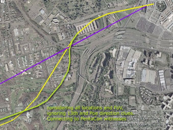
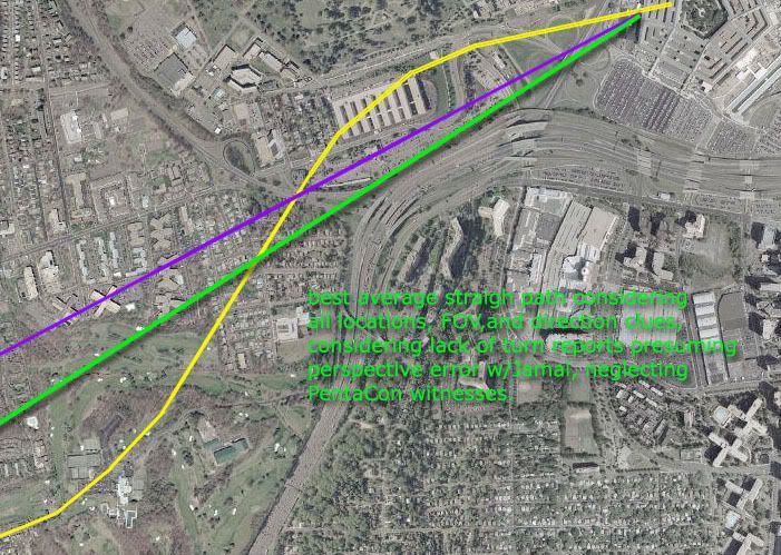
The “official path” (violet in the graphics below) runs roughly along I-395 at its bend, but nearer parallel with Columbia Pike and the edge of the Navy Annex it flanks (the big harmonica building). The path had to be nearly straight but with a slight left curve and accompanying mild wing bank - left low, right high. After the Annex (entirely south), it passed south of the Citgo station (the smallish structure after), descending as it crossed Route 27, striking lamp poles, skimming the lawn, and entering the building low. The north path is also shown below for comparison, in yellow. This is CIT’s most-widely promoted possibility, never meant to be THE path, and shown to be aeronautically improbable (as have their others, to differing degrees). This angles across the Annex s-n, banking hard right along the way (left high), passing to the north of the Citgo almost at Arlington National Cemetery, descending a bit, then pulling up to fly over, yet somehow appearing to still impact low into the building.
The reason their case has some traction is the same reason that even 13 accounts can’t override the overwhelming case for the real event - eyewitnesses are the weakest type of evidence. Memory is notoriously prone to various errors and psychic distortions. Their memories are usually vague on trivial details like which side of a gas station the plane passed by, easy to be confused, misread, and maybe deliberately dishonest, especially when pushed on points like the above. There are however exceptions that freely and clearly delineate the “official path.” Now just as the whole point of NoC is that it means no impact, the unanimous impact reports could be taken as evidence the plane was on the path consistent with the damage caused. I could also use altitude clues to rule out a pull-up above the light poles, ruling out all but the “official path.” Either would make my job entirely too easy, so here I will only cite specific South of the Citgo (SoC) clues as they sporadically pop up. This is a short list and there are plenty of others that offer decent clues pointing directly at a south path, but these here are13 of the strongest that each confirm it in multiple ways.

1) Albert Hemphill
At the Navy Annex, “peering out of the window looking at the Pentagon.... the large silver cylinder of an aircraft appeared in my window, coming over my right shoulder as I faced the Westside of the Pentagon directly towards the heliport. The aircraft, looking to be either a 757 or Airbus, seemed to come directly over the annex, as if it had been following Columbia Pike.” He also gives the wing bank (remember, north path means left high) “He was slightly left wing down as he appeared in my line of sight […] As he crossed Route 110 he appeared to level his wings […] as he impacted low on the Westside of the building
2) Terry Morin
Another witness at the Annex (“FOB” in account). From his stated vantage point, Morin could only see the plane for the length and detail he describes if it were on the south path. CIT and Pilots for Truth have cited problems with the line of sight blocking final moment and this is valid – and doubly so for a plane passing entirely north of that line. "Teri" Morin has changed his once-vilified story and this one has gotten very weird, to hear the dispatches from CIT-land. I don’t believe them. This is what we know Terry Morin said right after the event:

“I started to hear an increasingly loud rumbling […] One to two seconds later the airliner came into my field of view. […] The aircraft was essentially right over the top of me and the outer portion of the FOB (flight path parallel the outer edge of the FOB). […] The plane had a silver body with red and blue stripes down the fuselage […] Within seconds the plane cleared the 8th Wing of BMDO and was heading directly towards the Pentagon. […] As the aircraft flew ever lower I started to lose sight of the actual airframe as a row of trees to the Northeast of the FOB blocked my view. I could now only see the tail of the aircraft.”

Trees to the northeast of the building is the only thing that doesn’t fit – he must mean northeast of where the plane had passed the Annex. These run along the Pike as it bends, at the crest of the hill looking down over the Pentagon (at the "n" in "line of sight"). Seeing stripes is consistent with it being a tad south of him and banked left.

3) Madelyn Zakhem
A VDOT employee previously published as a witness, Zakhem was verified by the LTW/CIT/Pickering entourage in August 2006. Aldo Marquis was not impressed and noted soon after participating “her account placed the plane "inches" from the roof of this small building [she was at]. With the left tilted down. Unfortunately, this would place it BELOW treetop level which we all know is impossible.” A figure of speech read too literally and debunked is a straw man tactic of course, and a convenient one, as the building that plane was (some number of) inches directly above, clearly puts it on the south path, and with the official bank to the left. Marquis later expanded at Above Top Secret : "Trees blocking her view. Madlene is a suspect witness. She is clearly lying about the flight path. We know because Edward blew it out of the water and we interviewed her, and now her bizarre behavior is explained.” [For Edward Paik, see below]. They can’t find any south path witnesses who’ll go on record, but the reason for strenuously denouncing this witness specifically IS that she’s a south path liar on record with THEM. So Aldo pulls the old Crypyo-Jew move: “Madlene Zackem, the lady with the jewish last name, Israeli accent while displaying a crucifix around her neck is not telling the truth about what she saw."

4) Edward Paik
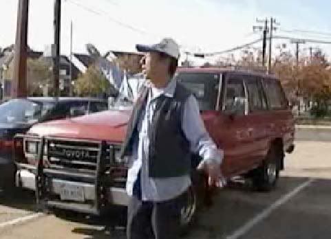
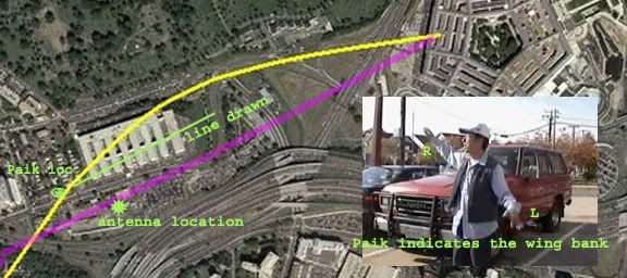
The guy who blows "Madlene"'s account "out of the water" is not really a strong case for a south path in that his testimony and flight path drawn for CIT in late 2006 directly contradicts it - three versions running across the Navy Annex and thus pointing either OTC (Over-the-Citgo) or slightly NoC. However, his account is jumbled and has south path clues mixed in. When he first talked to the CIT guys and Russell Pickering earlier, he had said he thought the plane clipped an antenna tower just south of Columbia Pike: the wing "knocked down the antenna… the plane was in the middle of the road… that’s why it hit the Antenna." It didn’t really do this, (or did it?) but for him to think so, it would have to be close to it, which it almost certainly was. Also even as he draws a path entirely north of the Pike, his instinctive gestures belie ambiguity, pointing almost straight down the road, and indicating a left bank, which directly contradicts the massive right bank needed to go ONA and NoC. I believe he’s a south path witness and for whatever reason his account came out sort of supporting the north path (really it’s right between the two). How odd that the guy who proves suspicious crypto-Jew Zakhem a liar matches her account more than it differs!
5) Keith Wheelhouse
Wheelhouse, the famous C-130 ‘shadowing’ witness, was actually ‘verified’ by CIT, and for their cameras DREW the south-of-Citgo path to a T. The graphic below is based on his drawing as shown by CIT, rotated correctly to north, CIT’s path added for reference, and his lines color-coded. Light blue is his 77 path, south of the Citgo, .Lavender is the C-130 divergence he put down, happening at about the same time. They already felt he was part of the “ambiguous blending” of the C-130 and the decoy - timewise - to disguise the flyover jet (oh, it was the other plane that veered away a few seconds later…). So this drawing only affirmed their suspicions that he’s a government operative by showing the decoy plane come in on the south path while the “2nd plane,” which he describes as a C-130, peels away well short of the impact point. Once ‘verified’ at least, this here could only provide cover for… the gray, 4-prop C-130 that flew that path about a minute after The silver/white 2-engine flyover plane that no one saw or reported anywhere near the fireball and flyover point is left naked. Some operative!

6) Alan Wallace
One of three firefighters at the heliport for the President’s scheduled arrival later in the day. “The plane had two big engines, appeared to be in level flight, and was only approximately 25 feet off the ground and only about 200 YARDS from our location.” He was a bit off on the color, but felt it was close enough to match: “The airplane appeared to be a Boeing 757 or an Air Bus 320- white with blue and orange stripes. Mark later recalled the plane was silver and even identified that it was American Airlines.” White/orange/blue – silver/red/blue - close enough. Similarly with heading? “I later said the plane approached the Pentagon at about a 45 degree angle, but later drawing showed it was closer to 60 degrees.” I’m presuming here he means relative to the building’s west wall, where 90 would be a perpendicular track. From this there are two 45 degree-angle paths (in orange below). His account shows no perceived discrepancy between the angle he thought he saw and the final official path he saw later, so we must look for the “45 degrees” closest to this. Which one is a fit for ANY proposed path?

7) Timmerman/Vignola
Witnesses Hugh “Tim” Timmerman and his then-girlfriend Dawn Vignola saw the plane from a upper-floor apartment south of impact. With a panoramic view, they were able to see most of the path from at least the Navy Annex and forward. Timmerman had more plane knowledge and lodged a detailed report, while Dawn first spoke to the news on 9/11 and years later talked with another person going by the name Plan 271 online, who drew this path (in blue) based on her description. The apartment location wrong and the view blocked by another building (long red arrow) is set a bit wide, perhaps to fudge it in the interests of privacy (too late!) So the span where it passed the Citgo is deduced – did it suddenly swerve north there? No, because it had no time to correct from the left turn it was observed in (surely not as shown here, distorted by perspective, but the idea is the same), and a north path would mean the plane pulled-up and over, but to these witnesses it seemingly crashed into the ground just before the building.
8) Father Stephen McGraw
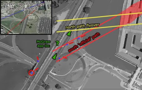
*Alleged witness DoJ lawyer and spooky just-ordained Opus Dei Catholic-priest* Stephen McGraw has described the flight path as from directly over his car, about 20 feet up and descending ahead of him and to his right to the impact point where he clearly saw it impact. He even told this to Aldo and Craig, and so all we need is his location to draw the path to the building, which CIT didn’t think to gather and hasn’t tried since. This line should also include, as McGraw deduced afterwards, the light pole that was clipped “just before it got to us” and the taxi damaged by it (see England, below) that was “just a few feet away from my car.” The plane passed from over the pole/cab area to over him and descended ahead all on a line he feels was “controlled and straight” into the building and CIT dismisses him as a “no-pather” witness and highly suspicious. CIT got no verification of his location, and they doubt he was at the scene at all, more likely fabricating for his Opus Dei NWO masters. He was placed in the correct spot (“a few feet” from England’s taxi and ahead of pole 1) in their graphics, “because we are typically discussing his account in the context of the official story,” which, in CIT land, is now a proven lie.
9) Penny Elgas
Headed north on Route 27 “almost in front of the Pentagon,” Penny Elgas reported “I heard a rumble, looked out my driver's side window and realized that I was looking at the nose of an airplane coming straight at us from over the road (Columbia Pike) that runs perpendicular to the road I was on. The plane just appeared there - very low in the air, to the side of (and not much above) the CITGO gas station that I never knew was there.” Finally a witness that mentions the Citgo, and a reason others don’t, and a side! It’s tempting to simply declare it was passing along Columbia, which puts it south, but she only placed it over the road. Below I offer NoC and SoC variants for comparison. She recalled it coming “toward my car” and passing low “about 4-5 car lengths in front of me.” Along the way, the plane was descending and “banked in the slightest turn in front of me, toward the heliport.” Left or right turn? Coming from NoC, it’d have to bank right, which means right wing low. South path could be level and straight or, some evidence shows, banking slightly left wing low. With the right wing closest to her, Elgas said “I saw the end of the wing closest to me and the underside of the other wing as that other wing rocked slightly toward the ground.”
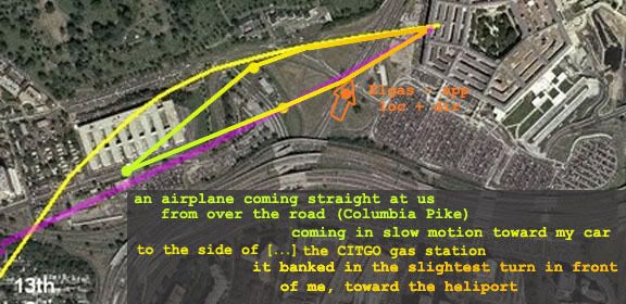
Straight at her, banking left and passing ahead of, and then impacting, which she is quite clear on. She actually had a piece of the plane
land in her car
, confirming her location about under the plane as it started losing parts, which a NoC plane would not do. She is a south path witness, plain as day, and no hunt was necessary. Why does CIT still claim no published SoC witnesses even though this one is quite well-published? Oh she’s all kinds of suspicious, her account is too public, too detailed, the plane part thing is too weird, and she has government connections. Not a real DC witness and not worth talking to. “Penny Elgas has a significant position in government and a very high profile highly publicized account so should be instantly considered suspect," they say.

10) NEIT 567
This witness is among the CMH interviews, designated with a number like the rest, and according to CIT “one of the most compelling accounts.” A member of an Army band who was at the ANC, her location as read by CIT is actually accurate, I believe, and labeled below. Partial account:

“I hear what I think is a fly over, over my head because that's standard. [...] And I looked, I looked directly up for it, and I also had some tree cover so I wasn't able to see, but I was facing the Pentagon [...] And we're facing the site that was struck. And that's what was also weird, is that it seemed like it struck on the other side whereas I found out later, I saw [the impact point?] so that whatever plane that disappeared, it was it happened so quickly.”

Aldo Marquis announced “She describes the plane as being "over my head" and having looked "directly up" for it which can only be the north side flight path,” which is not true. It would be A north path, but nowhere near the one they’ve been promoting. “Tree cover” implies a lateral distance with several trees in the way, rather than straight up through a single tree’s branches. This means it was at some distance, I think we can all agree to the south. Marquis also trumpets how she “thought that it flew over the Pentagon and crashed on the other side!!! […] Sounds like a flyover account to me.” She said no such thing. What did she mean about the other side thing? She knew where it hit, so we have four choices to work with here, below. Only one makes sense to me and it strongly implies a south path with perspective error.
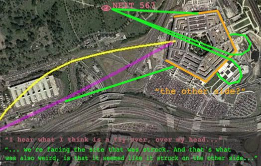
ETA: A more detailed debunking of her inclusion as a CIT NoC witness

11) Steve Riskus
Headed south on Route 27, well north of the crash site when he saw the plane come in low and crash square into the building. When offered a graphic showing two possible flight paths he explained “The plane looked like it was coming in about where you have the "MAX APPROACH" on that picture... I was at about where the "E" in "ANGLE OF CAMERA" is written when the plane hit...”
He erroneously gives his distance from the plane about 100 feet or so when he actually would have been over 1,000 feet up the road from the plane. A 10x factor mis-estimation might seem unlikely, but he himself placed the plane about right on the map and just that far away. Just not a numbers guy apparently, but definitely a south path witness.
Riskus also said “It knocked over a few light poles in its way,” but has affirmed to others and to me in an e-mail that he did not actually notice this event. Like most other pole-impact witnesses, he admits deducing this from the evidence and, one might suspect, from the match between the observed path and damage.

12) Wanda Ramey
However, at least one observer bucks the trend – DPS/PFPS officer Wanda Ramey says she saw the poles clipped by the plane. "I saw the wing of the plane clip the light post, and it made the plane slant. Then the engine revved up and crashed into the west side of the building.” Ramey says, explicitly, that she saw this, unlike most other deducing light pole witnesses. CIT say they have tried to find her and verify that she truly differs from the others, but have had no luck. The original article described her as having “a clear view” from “the mall plaza booth.” My best guess as to the exact location of this is included below, and gives here a wide-angle view from a moderate distance of about 900 feet from the pole impacts. Perhaps the key to noticing the pole pruning is distance, not closeness, as CIT have presumed.
ETA: Ramey was at some point interviewed by CIT, and they have made the audio available. They'd been trying a while to get ahold of here to confirm or deny that she saw the poles actually hit. She could do neither, after years of memory atrophy, etc,, couldn't recall if she actually saw that or not. She does however specify a left bank, the "slant" being the wing nearest her lower than the other, which further supports the south path.
13) Lloyd England
So suspicious is this elderly cab driver that he gets his own short video; ‘The First Known Accomplice?” It’s not surprising that CIT and their allies make a huge deal of his account all over the place and put his damaged taxi cab on their main page. Unluckily for their case, he’s the best light pole witness, who says plane that passed right over his car “was so low it hit the light pole. And when it hit the pole it knocked the light part off and nothing came through the car but the pole itself." He screeched to a halt at an angle there, he says. “Did you actually SEE the plane hit the poles,” the old CIT standard, gets real silly in this case, but oddly enough, even Lloyd, who was closest of all, failed to actually SEE the pole(s) being struck, and offers a possible clue to why others missed it. He told the CIT/LTW/Pickering “elite research team” “this airplane flew over top of my car. It was real close, and uh, I just looked at it. And when I looked at it flying over, something - [glass?] - a loud noise happened and the pole came through the dashboard, right through the car, all the way to the rear.”

This looks bad for their planted light debris theory. Luckily, the specifics of England’s accountare problematic. He has clarified in detail how the big curved pole segment is what stabbed his car and nearly killed him (the one out front in the picture below). That this would enter the windshield and come to rest long heavy end out as he says without leaving a mark on the hood doesn’t make much sense. This proves nothing except that a witness is telling a story that apparently makes no sense; his windshield was likely damaged by a different pieces than he says, and he constructed the memory he’s shared, perhaps honestly or perhaps not. This shows why witness accounts are weaker than objective verifiable evidence, but CIT is determined to make it a strong something. Since “his story is physically impossible and proven false by the evidence,” they’ve decided he was actuallt involved in the planting of the pole and was making the story up to cover for it. They’re unsure if he’s a willing accomplice or simply a “coerced […] victim,” but simply wrong is not an option, nor is it conceivable to them that he’s actually right, even though most people who think it out can’t see how.

As the CIT video asks of this account, “isn’t it interesting how Lloyd’s story supports the official flight path while being irreconcilable with the eyewitness flight path?” That’s right – not a witness. “At this point the debate regarding what happened at the Pentagon boils down to whether you choose to believe the CITGO witnesses or Lloyd.” Well whaddya know, a fasle dichotomy.

Conclusion: 8=0?
CIT’s wild-eyed fast talker Ranke recently reiterated the bogus claim yet again, in response to Mangoose at the JREF forum: “None of the witnesses we spoke with placed the plane on the south side of the gas station.”

Alright then, just from this list of people who place (or at least strongly imply) Flight 77 SoC, they spoke with Zakhem (understood her south path testimony, and used it to dismiss itself), Vignola (breaking agreements and burning bridges along the way), and with that liar Wheelhouse (it was THEY who gave him the paper to draw his south path on!) When they talked with Paik, and got him to draw lines that were either NoC or OtC they also video-recorded his south-path-supporting gestures. They of course talked to Morin, Ranke says, and I think they talked with Riskus via e-mail as it seems everyone has. McGraw spoke more with Avery and Pickering, but CIT was present at the taping, and they used the footage in a video dedicated to tearing down and obfuscating his south path testimony. Same with Lloyd England, and they even make it look like they defied ‘the devil by stealing his cab light. Where’s Mr. T when you need him to defend his fellow DC cab drivers? So just out of these thirteen south path witnesses, the CIT have spoken with EIGHT! Of these eight witnesses, at least four have been strenuously dismissed as non-witnesses of the most sinister kind, doubt cast on two, and two distorted and claimed as NoC after all. So by CIT logic, no, they haven’t found any south path witnesses in their journeys and likely never will. That’s just neat how much they’re winning. Good for them.
---
Post-13 witnesses with no graphics guaranteed:
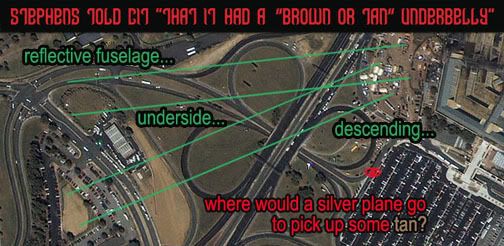
14) Here's another, if weaker, SoC witness, using Aldo's formula for NEIT 567: Levi Stephens, who later is said to have said it was NoC, had earlier said "I was driving away from the Pentagon in the South Pentagon lot when I hear this huge rumble, the ground started shaking … I saw this [plane] come flying over the Navy Annex. It flew over the van and I looked back and I saw this huge explosion, black smoke everywhere." Now no one is saying it was directly over the van, but how far NoC could it be and even seem that way? Hasn't he been placed around the lane one area? Why does he report a plane over there before the explosion rather than "after" like Roberts?
ETA: Also, a real SoC view is strengthened by CIT's own interview with Stephens, where they say he says it was north of the Citgo. As if it helps their case, they point out how he thought it was not an AA jet due to its unusual paint scheme - including a brown or tan underbelly. No one else really reported this (except I think Omar Campos), and most people thought it was a silver in color, as AA would be. Funny enough, the bottom of a silver plane would reflect the colors beneath it. A north-of-Citgo path would mostly show grass green, while a SoC passage would put it over the brown or tan unseeded, just built dirt mound just south of the station.
15) Roosevelt Roberts: Speaking of Roberts, his full interview reveals quite clearly a witness to Flight 77's actual SoC approach. It was a silver airliner with jet engines, he saw it in the space to the west over the south lot ("around the lane one area"). It was coming from the west ("from the 27 side ... heading east towards DC", from the southwest, past where I-395 merges with Route 27, from "almost like where that ne- that first plane had, um. . . flew into the, um, Pentagon right there. It- it- di- it looked like it came from that direction." And it was banking about 50-100 feet above the ground, just above the light poles. All the stuff about a second plane headed away is made up. The "another plane" he saw was clearly NOT after 77's impact, if he saw it coming in on the path 77 took, at its altitude, with its appearance.

16) NEIT 405: Another CMH interviewee, on one of the walkways on either side of the loading dock at the south lot. So nearly the same position as Roberts. "Walking on that elevated area that's right outside the door. It's actually on the second floor level. And I turned and glanced off to my right [...] I saw a plane coming over 395 and very, very low. Essentially coming into eye level as it flew across 395 and come across the end of the south parking off to my right as I went through that door." Across 395 probably means 27, and it appearing over the end (lane one edge) of the lot indicates it was probably SoC.

17) George Aman: CMH witness NEIT 419, Arlington Nat'l Cemetery facilities manager, inside a south-facing office at the time of the attack. He saw the plane descending and impacting out the window, and said so to CIT. His ability to determine just how far away it was or what it was over, would have been very limited. He placed it as passing between the Citgo and the ANC south maintenance parking lot. That's north of the Citgo, about as far north as witness should be expected to warp a plane passing them over a great distance. [Fuller explanation]. So how on earth is he a SoC witness? Light poles. CIT says no one actually saw them get hit. Ramey had said she did but can't remember now when they ask. Brooks said he did, but recanted to CIT. It was deduction, he said. George Aman, from his perspective, had a clear view of the first poles up on the bridge mound a few hundred feet away, and had said back in 2001/02 "When I was looking over here and I seen things fly up in there, not knowing really what the hell they were but come to find out they were street lights. So the plane was clipping the tops of the streetlights off." CIT had every chance to ask him if he deduced this, but just decided instead that he clearly was and it wasn't worth asking. [see comments at link above] They know he's a SoC witness.
Tuesday, March 18, 2008

OBSTACLE? IMPOSSIBLE.

OBSTACLE? IMPOSSIBLE.
WHY THIS ANTENNA THING IS A NON-ISSUE
Adam Larson / Caustic Logic
The Frustrating Fraud
March 18 2008
last update 3/23 3am


Okay, so here’s my response to Rob Balsamo’s new masterpiece Arlington Topography, Obstacles Make American 77 Final Leg Impossible. Yet again, we hear, some things taken together with other things have again proven the official story of the Pentagon attack is physically impossible. He dated the piece March 13 so he could say dramatically “"Beware The Ides Of March" could not be a more appropriate introduction to this article as it appears the government story regarding the events at the pentagon is officially dead.” Again the merry-go-round spins and in the end… again…. everyone disagrees still. I weary of this game, and this latest seems really a pathetic attempt. But it is in my area and people have asked my opinion, so I guess I need to cover it.

After infinite CIT re-posts of Pilots for Truth misfindings, it seems it was Rob Balsamo’s turn to catch them back. “Thanks to the hard work done by Citizen Investigation Team, they alerted us to review figures regarding topography and obstacles along the flight path of American 77 according to the government story. […] According to the government, American 77 final approach to the pentagon is depicted below.”
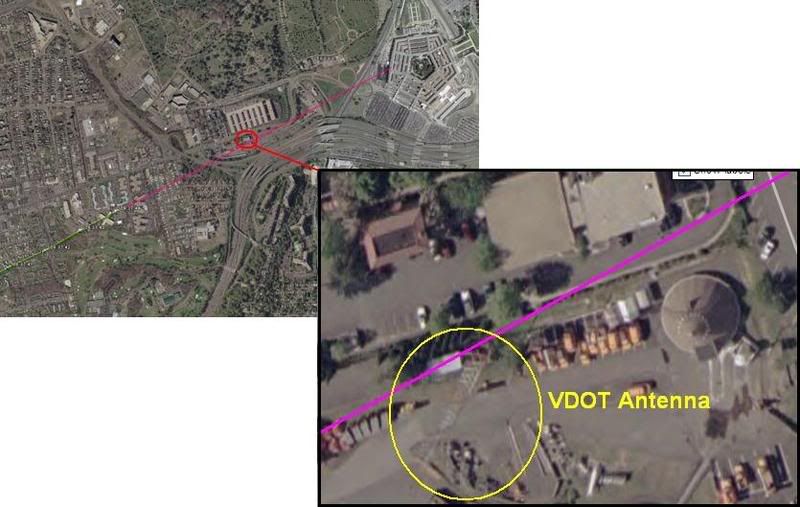
This graphic is not produced by the government, but by Merc Mercy CIT. I’m sure it’s fairly close to accurate, but is it close enough to say where the plane was relative to this 5-foot wide ‘obstacle?’ I’d have to say no. But Balsamo acts as if the government had drawn the line that took the plane right into or over this VDOT transmitter tower, 169 ft tall (including 6-foot antennas on top) above a ground elevation of 135 feet. He never explains whether or not this tower WAS hit, just takes a point right above it as a starting point. From this he did a bunch of math, with too many steps it seems to me, and decided that such a descent from above the tower to the light poles and into the building level would require 11.2 Gs of force.

“Conclusion = Impossible for any transport category aircraft to descend from top of VDOT Antenna to top of pole 1 and pull level to "impact hole" as reported by the government story and seen in the DoD "5 Frames Video". 11.2 G's was never recorded in the FDR. 11.2 G's would rip the aircraft apart.”

I don’t intend to get into the math of all this, but John Farmer’s response is worthy of note: Mission impossible He found that Balsamo’s numbers didn’t add up to what he said they did, double-checked and found the g-force would be 3.5, not 11.2. “So “impossible” is not the word I would use Rob.”

Then he also passed on the video interview of witness Ed Paik explaining how the antenna on top was indeed damaged. Somehow this was not included in Balsamo’s post even though his sources were there when Paik said this. Ranke had to add after that indeed Paik said this but, as Ranke explained back in 2006 “he just deduced this because he saw them working on it the next day. We confirmed with the VDOT employees that the antenna was not clipped.”

This maintenance was routine then, and just happened to occur one day after the plane flew right over it. Says CIT. Perhaps… But doubts remain; the only photo anyone’s yet found that shows the tower on 9/11 after the strike, by Steve Riskus, shows some hints of a damaged antenna, as Farmer discovered. I can see this, the deformation of the shorter right spire, and it's an intriguing possibility; as Arabesque puts it:

""We have a plane that many witnessed flying by the area the previous day. We have the flight data recorder suggesting that the plane might very well have been in line to hit the top of the tower and continue its trajectory; impacting the light poles and the Pentagon. We have a witness who confirms that the plane was flying at the approximate height of this tower and that he suspected that it was damaged from an impact with the plane as it was being repaired the next day--the two meter antenna replaced by a repair-man. If it can be proven that the tower was damaged from the incoming plane, this would be another compelling piece of evidence for the south of CITGO gas station approach and impact into the Pentagon; corroborated by the flight data recorder no less.""[e-mail]

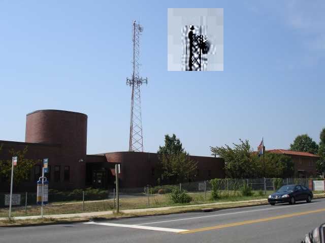
However, this photo is just not clear enough for me. It’s essentially a needle in the distance, lost in a digital haystack. Any slight artifact will warp it too easily. In fact when people were TRYING to take a good picture in 2006, it almost looks like one antenna is missing entirely (below). I don’t think we’ll ever see a picture clear enough to say unless it was taken by the repairman, but I'd need to see better evidence it was NOT damaged before I'd believe that either (a copy of the work order for 9/12 stating the reason for the repair, for example). I’m leaving this aspect ambiguously undecided and moving on.
Whether the plane flew just over this spindly 'obstacle' or nicked its top, the descent issues are roughly the same - a descent from 305ft MSL to about 35-40, a total non-linear descent of 270 feet over a span of about 3400 feet. This means a descent of 165 feet from FDR last frame before the antenna and another app. 235 feet dropped from the antenna to the first light pole in the same rough distance but at higher speed. I'm no pilot, but a lower altitude at the tower makes a bit more sense.

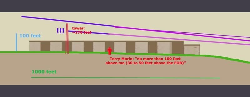
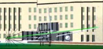
For a different aspect on aircraft height, Terry Morin at the Navy Annex (aka FOB) placed the Boeing “essentially right over the top of me and the outer portion of the FOB (flight path parallel the outer edge of the FOB). Everything was shaking and vibrating, including the ground. I estimate that the aircraft was no more than 100 feet above me (30 to 50 feet above the FOB) in a slight nose down attitude.” For this I’ll us a graphic I used earlier when CIT argued a similar problem relating to descent angles and impossible stuff, just updated a bit. It’s a panoramic graphic so here’s the right half with a reasonable descent angle to the light poles and impact.

And here is the important half, with the tower added to scale and cross-sectional placement. Oddly, my previous lines extended back take it over the tower neatly, but that’s a pretty steep descent. It looks like it would cause 3.5-11.2 Gs, considering the range offered so far. If we take Morin’s account as closer, which I tend to, it had to be much lower, which offers a more reasonable pitch, but takes the plane well below the top of the tower. This means an impact if Merc’s government line is accurate.

But I doubt it is. Flight paths aren't perfectly straight. They wiggle a bit, especially I would think at high speeds in the lower atmosphere. In another post I established that the witness record and physical damage best fits with a moderate left bank over the Navy annex, and likely a slight left curve to the flight path between the Navy Annex and Route 27 where it leveled slightly, with an apparent left bank of about –5-6° evident in the impact damage.

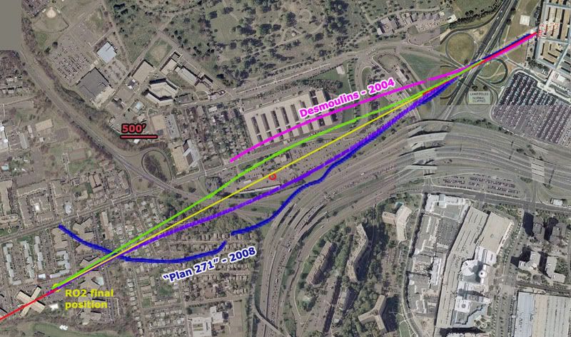
So considering all we know here is a proposal I offer: I had first favored the purple swerve, but after reviewing Morin I'm betting on the green line at the moment, or else the purple one.
- Final trajectory by pole and building damage - ≈ 61°
- Final FDR heading ≈ 59.9° (these are shown in red at the corners).
- The big yellow dot at lower left is the last reported position in the FDR data we have
- The yellow line a straight shot from there to the damage path. This indeed crosses over or within a few feet of the tower, probably too close for comfort if it weren’t high enough.
Before going graphically away from straight lines, I added for comparison two non-straight attempts to explain the ‘official’ evidence. In magenta a 2004 estimate by Jean-Pierre Desmoulins with a notable wiggle to it. He’s a pilot. Also in dark blue is an estimate by “Plan 271,” based on eyewitness reports from Dawn Vignola.

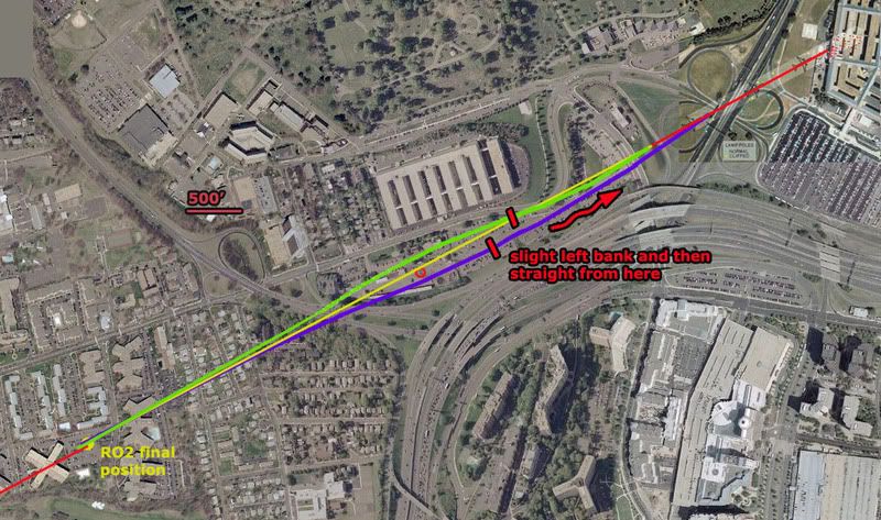
The two variations I’ve traced in green and purple are the most moderate explanations. While the green path fits best with Morin's account, the purple one is perhaps more consistent with left bank clues. Note the scale here – 500 feet is just a short line - and that each path is traced along the fuselage centerline. To clear the tower north or south it need only pass 62 feet away (124-foot wingspan). On closer inspection they pass about 250 feet from the tower, so I could’ve made them much milder. In fact I'm thinking the best fit is about 1/3 from the yellow line to the green one, with perhaps a left turn starting earlier, just after the tower, giving it a noticeable left tilt as it approached Route 27.

But even this extreme, both visibly look possible and reasonable – connecting two nearly identical trajectories with a gentle curve away and back, and still safely north or south of the tower. Altitude options open up. Either way, it looks like a reasonable avoidance procedure of a minor object on the attack path. if it were that low, which the witnesses and FDR seem to indicate.

Purple swerve - Max angle required to avoid the tower ≈ 68°
Min angle required to avoid the tower ≈ 53°
Green swerve - about the same
Time frame: app 6-7 seconds from the yellow dot
Any pilots? How impossible is that?

This is a non-issue – a needle of an obstacle that would be missed almost by definition if the path were anything other than perfectly straight, which it probably was. It’s also a non-issue because all previous attempts to ‘prove the official story impossible’ have failed under the test of verification. All that’s happening here is the wrong data being looked at the wrong way and attributed back to reality in a repeated straw man maneuver that’s giving many a case of hay fever. There is nothing impossible about what happened, and as a relative non-issue that seems prohibitively tedious to either prove or debunk I’m not even taking this one to the forums.
Update 3/23:
I took it to the forums a little. 9/11 Blogger (comments page 2) - Above Top Secret.com

update 3/19:

note: in the graphic above I somehow screwed up the 500' scale, making it actually represent about 400 feet. Luckily my margin was still wide enough that these mild swerves are still a fit, both passing well over 100 feet from the antenna tower.

update 3/21:
I just located again Russell Pickering's take on Paik's antenna memories from the old old LCF, 9/10/06:

"I went to the VDOT to confirm it hadn't been hit. It had not. Then in Edward's interview I asked him if he actually saw it hit the tower and he said no. Then I asked him if it hit the solid metal part of the tower and he said no. What he said was that it hit a smaller antenna of 2-3 meters in length on the top. He ended up telling us the reason he thought it had been hit was because he saw somebody up on the tower working the next day.

What had happened then is he incorporated a conclusion from something he saw later into his memory of the original account. The real story is that when the FBI took over the VDOT as a command post they added antennas to the tower for communication."
[emph. mine]

So it actually was not a coincidence people were up there the day after a plane flew by there. There was a direct cause and effect relationship between the two, as that plane had turned the area into a major hurking crime scene of the utmost national security importance. They needed many things, including communications. And perhaps the old antenna was also coincidentally damaged by the plane and replaced at the same time. That certainly can't be ruled out and in fact may well be the case judging by the new evidence coming to light. And that would certainly be another problem for the north path fly over story.

Update 3/23: CIT's take was not coincidence of antenna work but rather that it was not damage-related. They seem the feel it was the military, not the FBI, who put up the new antenna. And we have further confirmation that it was not damaged: John Farmer has confirmed the fact again with the VDOT smart center manager. He offered no details beyond "that was not true!," but as Farmer noted "if anyone should know it would be him (he would have to approve the replacement cost since he was the manager)." [e-mail]

Sunday, March 2, 2008

BANK NOTES

BANK NOTES
Adam Larson / Caustic Logic
The Frustrating Fraud
February 15 2008
updated 2/26 2am


Do You Even Know What A Bank is? Just Curious.
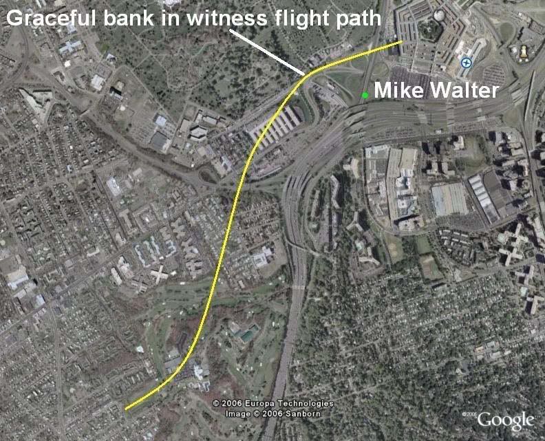
- Craig Ranke: "The plane banked over the Navy Annex [...] Did you know that even Mike Walter claims the plane banked?"
- Craig Ranke: "a bank in his view AT ALL completely destroys the official story."
- Aldo Marquis: "Ever speak to Mike Walter about seeing the plane in a bank? Just curious."
[source for both]

He asks because they did speak to Walter about the bank! At JREF back in April 2007 Ranke (as Lyte Trip) posted this text and graphic:
"He contradicts the official flight path. He claims he saw the plane do a "graceful bank" before gaining speed and flying into the building. There would be no "bank" in the official fllight path whatsoever that he could possibly see on route 27. But there most certainly IS a bank in the eyewitness flight path that we report!" [emph mine]
So Mr. Trip and his fellow citizen would have us believe that in the 'official story' "there would be no "bank" [...] whatsoever that he could possibly see on route 27." This is flat false. To understand what's up with this I need to clarify some confusion/conflation. To some minds a 'bank' is indistinguishable from a 'turn,' but a turn, as we all know, is a general changing of direction, while bank is:

"The angle between the wings and the horizon, as viewed from the rear of the airplane. An airplane with its wings level has zero degrees of bank. [...] Banking makes the plane turn. [...] This process is also called Roll." [source]

There is a natural, inevitable correlation between the two; usually banking means a turn just like smoke means a fire. However, just as smoke and fire are two different things, so are these two, and they can in fact be separated. A quick scan of anecdotal evidence - googling "bank without turning" and variations for about two hours - shows that its possible, and involves countering the tendency to turn using the rudder. In fact the rudder seems to be the key to both turning without banking and banking without turning. The best explanation I found is this, by Peter Sagar.

So when someone describes a plane 'banking,' they could possibly mean it colloquially as a turn, or they could mean - well, a bank of the wings, depending on the witness. This is a very important point to remember as we progress here, and when reading the analysis of Ranke and Marquis of Citizen Investigation Team, who make no such distinction. When they hear or say 'bank' they think or mean a turn, and refer to actual bank as 'tilt'. I've never heard them discuss tilt that I can recall, just bank, of course meaning turn. [explanation extracted here]

Discerning then the difference between the angle of a plane's wings and a general change of direction over space, let's address the normal relation between the two. If the right wing goes up, the left wing goes down, and the airplane is said to be in a bank to the left, and will naturally turn to the left. Any kid who zooms around on a bike will understand the concept. There are certainly formulas for bank/turn ratios, but in general, a level plane will go straight, and the steeper the roll, the tighter the resultant turn. How it's measured is seen from behind - right wing low is a positive number, and right high is a negative number. The tilt is measured in degrees, with level wings being 0 and wings straight up-and-down (plane sideways) being 90 degrees. Airliners try to stay level - a bank of 40 degrees is considered extreme, remarkable, rarely-seen, memorable, etc... Please keep this in mind.

Official Bank?
As CIT point out, the official story delivers a straight-shot path, about 70 degrees magnetic, 60 real, for at least two miles prior to impact. Therefore, any bank angle in the final stretch would be slight, or otherwise offset to keep straight. 'Straight' in this case is relative - the path may have had a slight bow that was not noticeable on the small scale most people saw it on. So in CIT terms, a straight line means no bank, and no bank probably means no tilt.

While there is no discernible turn in the official version of the final stretch, CIT will be saddened to learn that there is a bank [tilt] in the 'official story,' recorded in the physical evidence. A roll of about -6 degrees is evident in the wing prints at the facade impact point (IMO a bit more level and a few feet higher than shown here - ASCE graphic measured by me). This bank is generally consistent with the right-left damage before impact: the VDOT camera pole, tree damage, three light poles, diesel generator, etc. encountered by the right wing and engine at their respective heights, and two light poles, vent structure, trailers, and building foundation encountered by the left wing and engine. Though exact numbers are hard to deduce and the minutiae hotly debated, it's all consistent with a slight left bank like that shown here.

Due to the confusion over terminology, and other factors, debating this issue with CIT has been baffling, as they flatly state 'so-and-so wasn't in a position to see the bank,' etc. Couldn't see the bank? For God's sake, I railed... here's their own flyover animation: If I were right there being fooled by the flyover, nothing could fool me about its bank – about zero, perfectly level. So to be clear, they mean 'turn' in these cases and it makes sense that few witnesses would see a whole turn on the scale of even their tight yellow swerve. But since a turn is a change from one heading to another, and marked by a wing tilt as they call it, their recent eagerness to deny witnesses can see headings at all and their silence on 'tilt' are troubling. This leaves their findings very vague - and malleable.

FDR Insights
The numbers recorded for 'roll' in the original CSV file readout of the flight data recorder obtained by Pilots For Truth and others are instructive in what to expect in the last moments as far as turn and tilt. This quick list shows key points before and during its final turn (9:34-9:37, a right bank for nearly a full circle) and end of data:
h:mm:ss - roll
9:32:55 – +3.5
9:33:46 – +1.1
9:34:01 – +8.1
(nearly 8 degrees change in one second! The loop starts here.)
9:34:38 – +29.5
9:35:55 – +37.6
9:36:32 – +16.9
9:37:10 – +10.9
9:37:20 – +2.8
9:37:30 – +3.2
9:37:35 – +2.1
9:37:40 - -0.4
9:37:41 - -0.7 (-0.3 change/sec)
9:37:42 - +1.1 (+1.8 change)
9:37:43 - +3.5 (+2.4)
9:37:44 - +6.3 (+2.8)
[note: C-130 pilot Steve O'Brien estimated the plane's bank as he passed it as 30-40 degrees. By radar he passed it around 9:35-9:36. See above for comparison.]

At 9:37:36 the magnetic heading first hits 70.0 degrees and thereafter is steady, alternating between 70.0 and 69.6. Roll at that time is nominal and then shifting even to a slight left bank, back to right near the end, and then what? A final reading of 6.3 would mean right wing was tilted down to about the same degree the physical evidence has it tilted up, as Pilots For 911 Truth have celebrated. But the FDR is no help in this area – it stopped recording, or was truncated, or something, shortly before that point, somewhere in the neighborhood of 6-8 seconds shy of impact, which would have been around 9:37:50-55. With 12-13 degrees change required that’s about 2 degrees/sec or less, which fits previous trends quite reasonably. But this is all guess work... the machine is silent, and we have the physical evidence and the eyewitnesses, one of which we've covered.

Eyeballs on Wings
So in establishing turns, even if we're calling them banks, it's important to note the direction of the bank. The CIT witness-adduced swerve is shown above in yellow, to scale with the 'official' loop in green recorded by FDR and radar from 9:34-9:37. Check the sample rolls above at these times, and realize the CIT swerve would require a sharp left turn over the driving range, in excess of 40 degrees, a rapid correction, then an equally sharp right turn over the Navy Annex, so a right bank, with left wing very high.

One witness CIT is very excited about, Sean Boger, with a prime view from the heliport, does seem to describe this: "As he was coming towards me it just seemed like he was tilting the aircraft to his right." Barring some confusion (tilted meaning up or down? His right or the plane's?) this sounds great. But he also puts the plane north of the Citgo, so a grain of salt is in order. I also note that as an aviation pro, Boger might've been expected to use the proper term bank, but instead chose the more vague 'tilt' which CIT settled on, as supporting the plane's right... bank.

Which it would, of course. Right tilt-bank means right bank-turn, and this is supported by others in conflict with the official story. Like Mike Walter we hear. LCF part-time member Bileduct calling CIT on using Walter's banking report: bileduct perma-banned, thread closed. In this well-managed thread, Bileduct ejaculated: "You have indicated that Mike Walter described the plane in a banking maneuver over the Navy Annex. Your exact words were "He described the bank in detail to me, Aldo, Dylan, and Russell." My question for you... Did he say the plane banked to the left or the right?" To this simple question Craig responded "To be honest I don't remember. […] But I do recall that he had the plane making a "graceful bank" as it approached, not directly in front of him." Bileduct gloated for a moment then posted one of Walter's published accounts:

"I will never forget that day, trapped in traffic and then I rolled down the window and heard the sound of the jet overhead. [...] I looked up and saw the underbelly of the jet as it gracefully banked, then I watched in shock as the jet basically lined up the Pentagon in its sights and began to scream towards the mammoth structure." [emph mine]

'Underbelly' means it was above him - obviously - and also tilted at least somewhat right wing high. This is a left bank, not a right one, in which case its belly would be turned away. And that this happened in the distance - where the hairpin tirn to the right was supposed to be happening - was doubly troubling. Craig quickly responded "I do not believe or trust Mike Walter for a single second and we have plenty of evidence to show deliberate contradictions in his account. [...] He could not see the underbelly. He did not see the underbelly. He could not have seen the underbelly or a bank on the official flight path as well. This is just ONE of many fatal contradictions demonstrating how Mike Walter's statements are not truthful." Oh, and the tilt-bank wasn't necessarily OVER Route 27 [he doesn't describe it there - abbsence of description = description of absence]. Though the building damage shows a left bank still evident AFTER the road.

So what do other witnesses in the area say?

- Anderson, from far to the north and high up: "I watched in horror as the plane flew at treetop level, banked slightly to the left, drug it's wing along the ground and slammed into the west wall of the Pentagon exploding into a giant orange fireball."
- Elgas, same basic position as Walter, facing north on 27: "The plane just appeared there, very low in the air, to the side of (and not much above) the CITGO gas station that I never knew was there. […] I saw the plane coming in slow motion toward my car and then it banked in the slightest turn in front of me, toward the heliport [...] It was far enough in front of me that I saw the end of the wing closest to me [right] and the underside of the other wing [left] as that other wing rocked slightly toward the ground." She cites a turn, using the word bank!
- Elliot, south-southeast of impact, watched it for several seconds: "I looked to my left and saw the plane coming in [...] It was banking and garnering speed."
- Hagos, on Columbia Pike (?): "It was tilting its wings up and down like it was trying to balance."
- Hemphill, at the east end of the Navy Annex, perfect view: "He was slightly left wing down as he appeared in my line of sight, as if he'd just "jinked" to avoid something. As he crossed Route [27] he appeared to level his wings, making a slight right [wing low] adjustment."
- Marra (on I-395 south of impact?): "The plane rolled left and then rolled right. Then he caught an edge of his wing on the ground." [which wing is unclear]
- Morrin, outside Navy Annex, under its path, plane dipping too low to see]: "I could now only see the tail of the aircraft. I believe I saw the tail dip slightly to the right indicating a minor turn [roll] in that direction." [The bank as it passed him is unclear. It was high above him and just south, but he could see the AA markings on its left side, which might mean it was in a left bank]
- Owens: "the left wing dipped and scraped the helicopter area just before the nose crashed into the southwest wall of the Pentagon."
- Storti, apartment, Crystal City: 'he watched the plane cross over Route 395, tip its left wing as it passed the Navy annex...'
- Thompson: “The plane looked as if it were coming in for a landing — cruising at a shallow angle, wings level, very steady.”[this shows the bank was relatively slight - ie graceful - which might explain why there aren't more bank reports]


The best fit for all of these is a moderate left bank over the Annex, right wing high, leveling slightly just before impact, but not enough to keep the left engine from - more-or-less - hitting the ground in the last instant. And of course impact itself looks to have happened at a bank of about -6 degrees. But this was faked, and we know there was a right bank, thanks to CIT's witness verification. Except Walter. Verified LIAR!
But who the hell is this guy? Why does he keep impersonating the plane with his right hand higher than the left? Wasn't he in the best spot to see the sharp right bank over the Navy Annex? This is Edward Paik, interviewed by CIT in 2006, who places the plane's overall path fairly close to where they needed it. In the interview he’s never ASKED about tilt-bank, and doesn’t TALK about it. CIT informs me in an earlier interview he was asked about it but said he didn't notice one. His lines are essentially straight indicating wings about level. Yet at 11:42 in The PentaCon [verify, go ahead], describing the black wings, he extends his arms, right hand high, relaxes the gesture then repeats it the same. Is it just some tic, a spinal misalignment? No, at 12:52, striking a jesus pose, facing the OTHER way he somehow puts his LEFT hand higher to indicate the right wing. He even seems to think about it a moment first. Coincidence? Perhaps. But interesting.

CIT claims I made up this left bank gesturing of one of their prime witnesses. They claim he didn't remember one at all. They claim the plane was bank-turning right over him. It had to be, and about halfway to knife-edge. This would necessarily mean an extreme tilt-bank, right wing very low. He might then talk about the wingtip being too close, rather than the whole plane. He might remember such a remarkable tilt when first interviewed. He might gesture it left hand high. He might draw at least a slight right curve in his path, if he saw what CIT insists he saw. Ed Paik does none of these. Just the gestures above.

Composite path turns required: one to the left, one to the right.
PentaCon Smoking Crack version witness bank reports: zero right, one left (perhaps anyways)
White Plane witness bank reports: zero left, zero right.
Completely made up extreme turns to play connect-the-dots? Two. One left, one right.

Estimated wing bank accompanying the right turn according to experienced pilot 'Beachnut'?
"Take a google earth with the yellow path from Pentacon! You then find the radius of turn. From the radius and the speed from the FDR you get the need for something like 80 degrees of bank and 8.7 gs with the wings falling off in a big snap! Just take the radius and speed and look up an aircraft turn equation. Makes the turns required by the CIT to be impossible; as in made up."
---
Additional Discussion at Above Top Secret:
Main thread Craig wouldn't touch
Vs. thread Craig revived as a distraction, where we chatted a bit about bank (pages 3-4).

Sunday, February 10, 2008

THE LADIES OF 13th AND POE

CIT WITNESS VERIFICATION PART II: THE LADIES OF 13th AND POE
Adam Larson / Caustic Logic
The Frustrating Fraud
February 3 2008
update 2/11 2am


Note: Thanks to LCF member bileduct for starting me seeing these patterns. This here is the “Convoluted manipulative disinfo” version of the article, which explains all my points adequately. For those with less patience, see also my “despicable scumbag” summary version.

Northern Redezvous / Southern Anchor
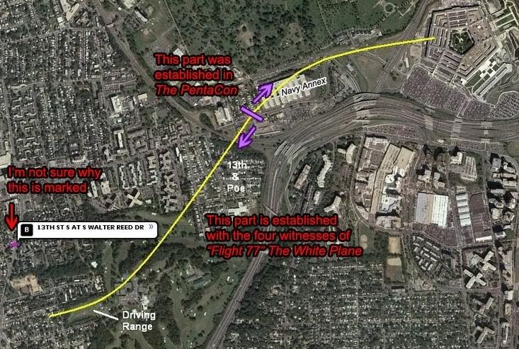
Craig Ranke, the argumentative co-founder of Citizen Investigation Team (CIT) announced back on December 10 2007 the release of their new video "Flight 77" The White Plane: “CIT further exposes the mainstream media cover-up with this extremely important new 37 minute short revealing what the people of Arlington REALLY saw on 9/11.” [source] Their early 2007 video The PentaCon had already set the damning flight path from the Pentagon, north of the Citgo, and back to the Navy Annex (see graphic below). This follow up is centered on four witnesses further back along the flight path, and their main finding, as the title implies, is that “the plane people saw tree top level over Arlington timed perfectly with the explosion at the Pentagon was white.” They speak of a “media cover-up of this white jet” to be confused with and erased by the E4B that circled the capitol shortly afterwards. [source] The PentaCon witnesses had disagreed on the color but that didn’t matter; it was all about the flight path then. Now that four people used the word 'white,' this is reported as the most significant aspect and the flight path clues are ignored. For this reason I will first, in this piece, ignore the color issue and focus on what CIT has downplayed – what the plane was remembere to have actually done with its whiteness, according to these witnesses.

This new eyewitness data, in addition to the old, gave CIT as an inescapable reality this yellow swerve (red labels and arrows mine), what Craig has elsewhere described as “the flight path that has been getting established for us by the people of Arlington.” While the curves are extreme for an aircraft that size, I’d guess this path is entirely possible for a 757. However I cannot visualize it happening without two very sharp turns with accompanying steep wing banks - one turn left, with right wing pointed up towards the sun, a rapid leveling and straightening on a more northerly heading, then an even sharper turn to the right, during which its right wing would need to be dipped quite low over the Navy Annex. Keep this in mind when looking at this as it has been re-created in the graphics below, yellow each time. The southern portion of this path, from the Navy Annex down, is what The White Plane and its witnesses are said to illustrate.

Here is the video itself for reference: If you want to watch the whole thing, I recommend reading this full piece first.

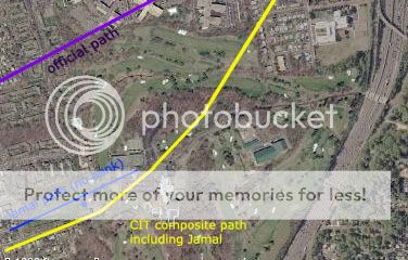
The White Plane begins with Jamal El Kournayti, a caddy or something at the Army Navy Country Club on 9/11; as narrator A. Marquis puts it, “Jamal’s account gives us a strong starting point for our flight path.” This it does, by placing the plane well south of the previous accounts, which might seem ironic, since their original path was north of the official one. But this is also the only account of the four that, on its own considered merits, even seems to contradict the official path. El Kournayti's is the most specifically illustrated stretch, referenced to specific trees at either end of the range, which he says the plane flew directly over. The path and location they draw for their video is accurate to what El Kournayti describes and is the better part of a half-mile off the ‘official path,’ but with about the same heading.
So if we’re starting out well south of the North-of-Citgo path, the attack plane had to connect to PentaCon witness Edward Paik, at the west end of the Navy Annex NNE of the end of the driving range. Both men would be near the hinge points where heading changed and should have reported a turn or at least the accompanying bank. However Paik was never asked about any turn, and gave clues only indicating a straight path. Likewise El Kournayti is never asked about and never mentions any bank of the wings or turn in the flight path. His gestures indicate a straight sweep across the sky on a bearing I map out at approximately 65°. So somewhere between Jamal and Edward the plane would need to shift to the north and do all its remarkable turning, banking, and leveling; it’s clear at this point that a lot was riding on the witnesses of south Arlington who occupied that span.

Canvassing / Mrs. Hubbard
In between Jamal and Edward there were neighborhoods to screen for “additional previously unknown witnesses,” neighborhoods like the one they call 13th and Poe, which is probably what the locals call it too, since it has such an uncanny – if unlucky - ring to it. Canvassing the few long streets of this mini-borough Nestled between I-395 and Washington Blvd, south of the Navy Annex, and north of Hoffman Boston Elementary School, Ranke found it, “painfully clear that the people on the street report something different than the suspect witness accounts reported by the mainstream media.” The PentaCon’s four North-of-Citgo witnesses had their four flight paths, hand drawn over aerial images of the attack; here again we have four witnesses but oddly not a single drawn flight path among them. Craig explained to me “I didn't have images prepared for people I did not know I would randomly find from canvassing. Only for the pre-arranged interviews.” Granted, aerial long-views of every possible POV cannot be prepared, but a satellite map the witness could read relative to their view might work. Something could have, should have, been improvised to get some graphic confirmation. And wouldn’t you know it… Jamal and then at least three new witnesses found and interviewed around 13th and Poe, all supporting the logical extension of their previous groundbreaking findings we’re told, but not a pen-stroke of that good stuff to show for it.

The first witness presented after Jamal is Mrs. Hubbard, who was interviewed on the porch of her home on the west side of S Poe st just off 13th. Ranke did confirm for me that her window points on Poe street, which would offer a view to the east. Not only is there no flight path drawn by her, but no visual clues shared whatsoever; she declined to be videotaped and talks unseen, mentioning ‘numerous clues indicating some flight path:

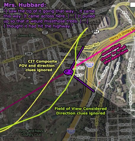
“It came right between these two houses […] I saw the tip of it going that way [...] It came this way. It came across here. And it went between the house with the gray roof […] and the big house. It pulled up so that it would miss those trees and then the next thing I saw was the puff of smoke.”

Which houses? Which trees? I’ve scanned satellite photos for what she might mean but don’t feel comfortable settling on a path and with CIT being and helpful as they have with their verification, the best I have to go on is the facts that she saw it, and “I thought it had hit the highway,” meaning the raised curving portion of I-395 northeast of her east-facing den window. But CIT’s yellow composite squiggle passes entirely behind her house and out of view. She’s included as a witness to this path’s middle stretch, but for Mrs. Hubbard to have actually seen this path, it would have to curve at least somewhat to the east of her den window, then almost due north to the corner of the Navy Annex, complicating the required turn to the right to rendezvous with Ed Paik’s line. I think I know why they fudged it back behind her, (see below) but it’s just fudging, CIT would say, and probably not a sign that she’s a plant. She clearly, literally “saw the "tail" of the plane,” Craig explains, “headed towards Edward Paik coming from Jamal.” In reality, she never mentioned either man in her account and it’s not even clear if the three know each other.

Before we can go any further then we must revise the middle portion – to pass in front of her house, which will in turn effect the remaining two witnesses. To connect the accounts of El Kourtayni and Paik while offering Hubbard a view, it would have to fly a bit further east than CIT shows, then turn near north, a heading of about 15-20° from true north, running entirely parallel to I-395. While her directional clues are still vague, I would offer the magenta line as at least better fitted to her thinking it crashed into the freeway somewhere in the distance. This is very different from what CIT decided she saw, even once it’s adjusted to be possible.


The Cousins With A Bathroom View

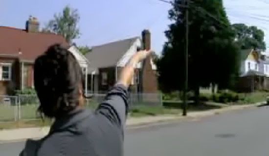
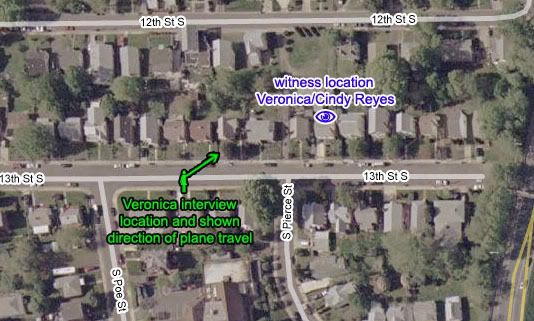
Veronica (first name only) was interviewed apparently in the August 2006 elite research foray, since Russell Pickering is visible and actually doing most of the questioning. She seems to be standing on 13th street, between S Poe and S Pierce streets, facing north and away from the camera for her entire interview. The segment starts out with her pointing out the plane’s flight path, having been apparently asked about it right before. She also points about the same direction to her location at the time, her cousin’s house on the north side of the street, from a window in the back facing north. “We were at my cousin’s house over here; she’s got a window in the back ‘cause she was in the bathroom,” Veronica explained. This makes it sound as if she herself didn’t see it, but was merely passing along her cousin’s account. But the rest of her account makes it indeed seem that she herself, if unclearly, saw "the white go by." However she learned of it, she seems pretty sure of the plane’s general trajectory, her repeated arm gestures clearly indicating east-northeast, inconsistent with CIT’s yellow composite path and far inconsistent with my corrected yellow-green path from east of Mrs. Hubbard’s window. She also describes no kind of turn or associated wing bank of a plane swooping north and arcing east over the Navy Annex, repeatedly tracing a straight line across the sky, the only conclusive visual clue offered by any of the ladies of 13th and Poe that actually got through to the viewers of The White Plane.
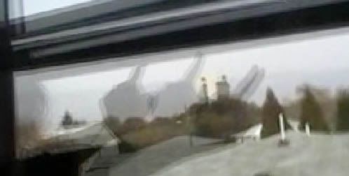
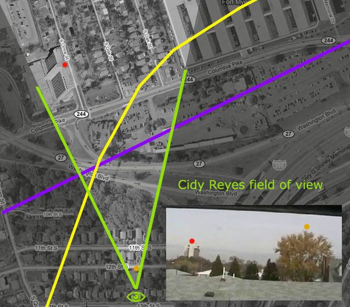
All this is ignored by CIT, and Veronica’s account is used primarily to corroborate the plane as white, and as an introduction to her cousin, Cindy Reyes, “who got a better look at the airplane” and did an even better job with setting the color trend. Reyes showed her face and spoke candidly after letting the interviewers in to stand in her bathroom and see what her view was like, a panoramic one looking almost due north, revealing the Sheraton hotel in the distance and the Navy Annex just out of view to the northeast. Her descriptions and gestures against that window indicate a descent to what seemed treetop level. For its lateral direction, she gestures from left to right, but it’s unclear if she’s trying to indicate three-dimensional movement, or just tracing across the window pane like one might a TV screen. There is some obvious confusion in the interview about left vs. behind (her left then or their behind now?), which leaves her directional and perspective clues vague.

When challenged, CIT has refused to draw the path they think she saw on a map anywhere, so I decided to try my own from clues she freely offered. There was a predominantly left-right (west-to-east) motion, but it was not purely seen from the side but “at an angle.” I’d like to emphasize an angle, as in singular. Nowhere does she mention or is she asked about seeing any change of angle, any turn of the airplane. Whether they knew it at the time or not, this is the spot where it would have to turn sharply to a more easterly heading. And of course such a sharp turn, coming in from Mrs. Hubbard’s FoV, would require a pronounced wing bank, which she also does not mention and is not asked about.

In attempting a guess of her flight path, remember that she and Veronica supposedly saw the same thing from about the same location, and that Veronica’s gestures seemed to indicate ENE. Both paths in the graphic above agree on general distance from the window, but angle and turn are in question. This double-corroborated testimony of Cindy and Veronica seems to more strongly support the purple line, which is in fact the precise “official path” of Flight 77, or something quite similar.

Constructing the Flight Path
Among the 13th and Poe witnesses there are clearly no direct clues for the middle stretch of the yellow CIT squiggle, and in fact some serious points against it. The Citizen Investigators tacitly admit this in discussions by downplaying flight path evidence altogether. After the revolutionary flight path up north, it's all about the color and the location of - something. The issue of plane direction is clearly back-burner now:

“We KNOW that none of their accounts are perfect. […] They only need to be approximately correct. […] there is no need to determine the exact placement of the plane or a flight path at all. […] It is unreasonable to suggest that it is even possible to determine the exact placement of the plane from witness statements.” [source]

Craig in fact started a whole new thread at the new LCF in response to this piece, titled "No witness can accurately depict a flight path (The plane moved too fast)." This is a bad sign; they never admit something if there isn’t a way to twist it into appearing to support the thesis. Instead they fall back on presenting false dichotomies, like this one, that are getting falser the deeper I look:

“If you believe the official story you have to accept that virtually all of them are completely lying. […] So do you trust real people or do you trust the government? Is it more likely that they have a reasonable margin of error in their accounts or is it more likely that they are all completely lying and that the drastically different official story is true? That is pretty much your choice here.” [source - emph mine]

Clearly CIT doesn’t trust ‘their own’ people, taking the approach to flight path construction of “Draw a line from where Jamal saw the plane to where the citgo witnesses saw the plane. […] That's what we did. That is scientific, logical, and the most accurate way to interpret this data.” So long as both placements are truly accurate and there’s supporting data in between, or at least no contradictory facts, this is certainly true. Unfortunately that is not the case here.

The explanation was also a challenge; “draw a line from where Jamal saw the plane to where the citgo witnesses saw the plane. […] Think of all of their placements as being approximate and create the best estimation you can using ALL of their accounts. Go ahead, do it and show me what you come up with.” Okay so here are some versions: CIT’s scientifical yellow swerve and the ‘official’ path, more or less, in purple for reference in each: and my readings of the White Plane witnesses read with three different sets of assumptions explained on each:


”Flight 77” The White Plane”, an “extremely important “ video “revealing what the people of Arlington REALLY saw on 9/11.” Hardly. As Asshole Marquis recently asked a fellow LCF member, and as I now deflect back to them:

“Are you so sick and demented that [the Ladies of 13th and Poe] are just values in a logic equation? Do they represent actual witnesses and human beings who are scared about what they saw or are they just names and statements that you can play circle games with because you think you understand "logic"?”

Tuesday, February 5, 2008

A FORK IN THE ROAD

A FORK IN THE ROAD: THE ANOMALOUS MEMORIAL
Adam Larson / Caustic Logic
The Frustrating Fraud
February 4 2008 3am


Looking at the testimony of Sgt. Chadwick Brooks as presented in The PentaCon, I found this sideline that, the more I look, gets more and more interesting. When asked where the plane he saw came in from, the Defense Protective Services officer pointed back to some trees and an oddly looming three-pronged structure in the near distance behind them. This curious form is seen above relative to the Citgo’s north canopy, with Brooks seeming to wear it like a crown and Lagasse looking back towards it almost as if noticing it for the first time and wondering ‘what is that thing?’ That’s what I was thinking anyway. It could serve almost no practical purpose, and looked like a work of art or monument of some sort, and right next to Arlington National Cemetery. So I dug in and found matching images for “memorial” + “Arlington” + “three spires.”

I quickly found that it was a recently-completed memorial to Air Force airmen who have died in the service of their country. MSNBC ran an Associated Press article about its dedication on October 14 2006 (less than a month prior to the Lagasse-Brooks interview). Just south of the cemetery, on a hill overlooking the Pentagon’s west side, roughly 30,000 people attended and listened to the keynote address by President Bush:

"Under these magnificent spires, we pay tribute to the men and women of the Air Force who stand ready to give all to their country. And looking from this promontory to a place once filled with smoke and flames, we remember why we need them." [1] [Youtube video of dedication ceremony]

A squadron of Thunderbirds then buzzed the area, executing the famous “bomb burst’ maneuver the memorial was meant to evoke. Usually done with four jets, the monument’s three upward arcs are based on the “missing man formation” traditionally flown at Air Force funerals. The first official ceremony was held the next day when the Secretary of the Air Force laid a memorial wreath at the base of the spires, capping the completion of a 30 million dollar, fifteen-year struggle to get them erected. [2]

The Air Force Memorial Foundation (AFMF) was formed and given 501(c)(3) status in 1992 to pursue a memorial, led by a five-man advisory committee including Ross Perot Jr. [2] The foundation was mostly funded by private contributions; Wayne Madsen wrote about how the project was funded “largely […] with donations from Lockheed Martin, Boeing, Northrop Grumman, Raytheon, United Technologies, and even the United Arab Emirates Air Force.” [3] The original plan was to place the memorial at Arlington Ridge, near the Marines’ Iwo Jima memorial, but all through the 1990s the AFMF remained locked in extended legal battles with the Marine Corps over this plan. In October 2000 President Clinton signed legislation to give them more time, and the DoD offered an alternate site at the east end of the Navy Annex, near the intersection of Columbia Pike and South Joyce Street. This offered the foundation a way around more costly litigation and the opposition of Congressional ex-Marines, but planning for the Arlington Ridge location continued.

The board members were still weighing their options when the 9/11 attacks occurred, including a near fly-by [see below] of the alternate site by Flight 77 on its way into the Pentagon. Some time in October 2001, the AMFM chronology states, the board of directors “acknowledges realization for relocation” to the Annex grounds. Over the next two months as the nation dealt with Afghans and Anthrax, Congress worked to include the site change as a rider on the 2002 Defense Authorization Bill, which President Bush signed on December 28, officially giving the Foundation up to three acres of the Naval Annex property on which to build. [2]

In 2002 the AFMF gathered its funds, solidified the site, and selected Pei Cobb Freed & Partners to design the memorial. It would be the final project for architect James Freed, previously responsible for the US Holocaust Memorial Museum. [4] In 2003 they got the paperwork lined up; in February the FAA decided the giant arcs would not be a "hazard to air navigation."” [2] Formal groundbreaking of the site was held in September 2004, foundation work done in 2005, and construction of the spires began in February 2006. On September 22 the last of fifteen spire segments was installed and the monument essentially completed, three weeks before the dedication ceremonies. [2]

Not everyone is a fan; Wayne Madsen wrote of how the monument sits “jutting into the sky and dominating the Washington, Dc skyline […] reminiscent of something Nikita Khrushchev would have built honoring the Soviet space program in a Soviet Potemkin city.” [3]

I’m not sure yet of the relevance of this memorial to my study of the Pentagon attack and those studying it, but a few oddities are at least worthy of note:
First, obviously, is its location; Madsen noted the spires jut out of a spot “right on the Pentagon crash flight path.” Can this be pure coincidence? It must be, most would think, since the site was selected a year before 9/11. And it’s not exactly on the path anyway; to be more precise, it’s placed along the line of a right-over-the-Citgo-flight path, between the CIT-crafted North path and the official one on which tons of damage happened five years before the spires went up, one year after the site was offered, and a few weeks before it was accepted.

Looking across the Annex from the west, I’m reminded of Edward Paik’s drawn flight paths that, oddly enough, point almost right to the monument, which was being assembled at the time he drew them.
Seen from this view it seems almost like a giant pitchfork they wish had been there to stop the plane that day, a symbolic retroactive warding-off of evil spirits. It is placed just a bit too far to the north, but even if they had truly meant to mark the very spot (presumably a post-9/11 decision to shift it a bit), this is the closest they could get without tearing out the curve of Columbia Pike. Even the most dedicated symbolism must sometimes yield to necessity.

A second oddity that stands out to me is its height – the highest of the three spires rises 270 feet above “the 3-acre elevated promontory site.” [2] This number sticks to me because of the radar altimeter reading in the last recorded frame of Flight 77’s FDR; 273 feet above ground level. This was probably not recorded adjacent to the memorial site, but rather a ways back. Nonetheless, it almost seems someone was trying to place those spears right at the belly of that plane if it should ever come back and try the same thing. However, it seems by looking at a few photos that the tallest spike is pointing northwest, which is not where the FDR shows it coming from, and it becomes clear I’m probably just reading too much into this.

Thirdly, the timing of its construction with CIT’s 2006 research trips means there was a brand new, gaudy, overwhelming structure being built right in the zone people were remembering their flight paths from. With the monument often cited as being ‘right on the flight path,’ it can’t be ruled out that it could have inserted some distortion into their recollections of where the flight path was.

Finally, I’m astonished that I’m just now learning about this. I may’ve heard a mention here or there, but had never been specifically aware of this mammoth trident amongst the contended flight paths. For one thing, it’s not shown in the supposedly current satellite views at Google Maps I’ve been looking at regularly for the last year and a half (hence the graphic I made, above). So now I’m aware of it and up-to-date, and would like to close on a poignant note speaking back to the subject of memorials to those who’ve given their all for whatever they’re calling ‘freedom’ these days, Wikipedia’s entry notes: “Although the current [memorial] design is somewhat overshadowed by the Navy Annex at Fort Myer, that facility is slated for demolition by 2010 with the site to be used for the southward expansion of Arlington National Cemetery.” [4]

Sources:
[1] Long-awaited Air Force Memorial dedicated
Arlington monument honors the memory of those fallen in youngest service. Associated Press. updated 8:12 p.m. ET, Sat., Oct. 14, 2006 http://www.msnbc.msn.com/id/15264524/
[2] http://www.airforcememorial.org/memorial/chronology.asp
[3] http://www.disgrunt.com/blog/2006/12/05/weird-horns-statue-dominates-washington-skyline/
[4] http://en.wikipedia.org/wiki/United_States_Air_Force_Memorial