Showing posts with label altitude. Show all posts

Sunday, September 21, 2008

PILOTS FOR 2+2=5

September 21 2008
possible updates


For what it's worth, Pilots For 9/11 Truth recently released a new video based on math and stupid, that tries to say some stuff about the Pentagon attack. They're hoping to sell it, and so maybe have a breakthrough to push it with, like finally deciding on a theory of what did happen rather than just raising leading questions pointing towards no plane hit, held back out of "professional caution" and responsibility. LMAO. Please do not buy it, unless you support their long-running practical joke on gullible suckers. I don't even plan to watch it, but their talking points about the video focus on the presence of some serious math to correct their earlier egregious errors, months in the process of correcting. I'm fully capable of understanding the formulas I either failed to learn or forgot after High School, but only with the kind of time and attention I won't devote to facts whose only purpose is to debunk stupid shit I already know is wrong. Therefore, for those inclined to follow the math, especially those who lean towards believing the video, here is a link to John farmer's posts breaking down the "errors."

PFT Fantasy Flight Path and further analysis.

Myself, I don't feel like wasting any time on this. But if I change my mind, I'll plunk more stuff into this link. This is quite sparse, so I'm sure I'll have to add something.
---
Their G-Force on final descent analysis was relesed for viewing in a promo short video. Essentially, it’s a response to their epic 11.2 G error (admitted even!), first proposed in the Arlington Topography piece earlier this year. The correction was several months in the making, and only slightly different - 10.14G in the best case scenario. Now 11.2 Gs was waaaay off from what everyone more reasonable found, and it would appear the reason for the still-large gap is that peoples’ presumptions differed. His descent path is shown here in yellow, my notes added.
They presume, as I knew, a descent from just above the antenna tower to low enough to strike the first light pole by the time it got there. Two problems – it did indeed have to end where they show, but not start. The antenna tower is maybe 5 feet wide, and there’s no evidence if it was directly over, to the left, or to the right of it. All we know is close, and judging by eyewitness accounts, it was considerably lower than the top, so either left or right (and I’m banking on left, or north).
Terry Morin: “I estimate that the aircraft was no more than 100 feet above me (30 to 50 feet above the FOB) in a slight nose down attitude.”
Edward Paik: "It almost hit my roof [...] If [the plane was a] little bit lower… it would have hit the [Navy Annex] building almost it seemed like. [The wing] knocked down the antenna… the plane was in the middle of the road… that’s why it hit the Antenna."

There is some evidence the antenna may well have been damaged, but it's not conclusive. If true, this would leave PffT's initial altitude presumption nearly correct, and contradicts the lowness described by both Morin and Paik. What correlates is a plane tens of feet above the Annex roof, I'd say closer to 30-50 feet above rather than 90-110 above as PfffT decide is the "lowest possible." It would be laterally quite near the tower, near enough to seem to have impacted it near the top. This would put it over Columbia Pike, and and running near-parallel the building's edge. Numerous witnesses (including Paik via gestures and Morin via seeing stripes on one side) confirm the plane was in a mild left bank, with right wing high. If the plane passed north of the tower, the right wingtip would be nearest the tower and its antenna at the top.

So, the descent from altitude, at the very least, cannot resonably be presumed as directly above the tower, greatly effecting the steepness of the resultant dive to the light poles. Second, and more important, the nature of the dive change is at issue – he has a sudden pivot, two straight lines bumping into each other, rather than like an actual plane's single uninterrupted parabolic curving movements. Ooops! My first comment was that this descent “has been sponsored by the letter L,” ala Sesame Street, and Reheat and other JREFers aptly took to calling it the ‘hockey stick’ descent. [Horatius did a funny comic strip on it] Apply sharp corners to “alleged” flight paths and you’ll force all change to one point and get unrealistic G-force calculations. Thanks PfffT for illustrating bad reasoning at work. Now just up the volume on the certainty language and demands for phone debates, and you can perhaps at least provoke people into wasting time, as a consolation prize for not being accurate.

Discussion on the G-Force video:
Pilots For 911 Truth
JREF
Above Top Secret
CIT forum

Tuesday, March 18, 2008

OBSTACLE? IMPOSSIBLE.

OBSTACLE? IMPOSSIBLE.
WHY THIS ANTENNA THING IS A NON-ISSUE
Adam Larson / Caustic Logic
The Frustrating Fraud
March 18 2008
last update 3/23 3am


Okay, so here’s my response to Rob Balsamo’s new masterpiece 
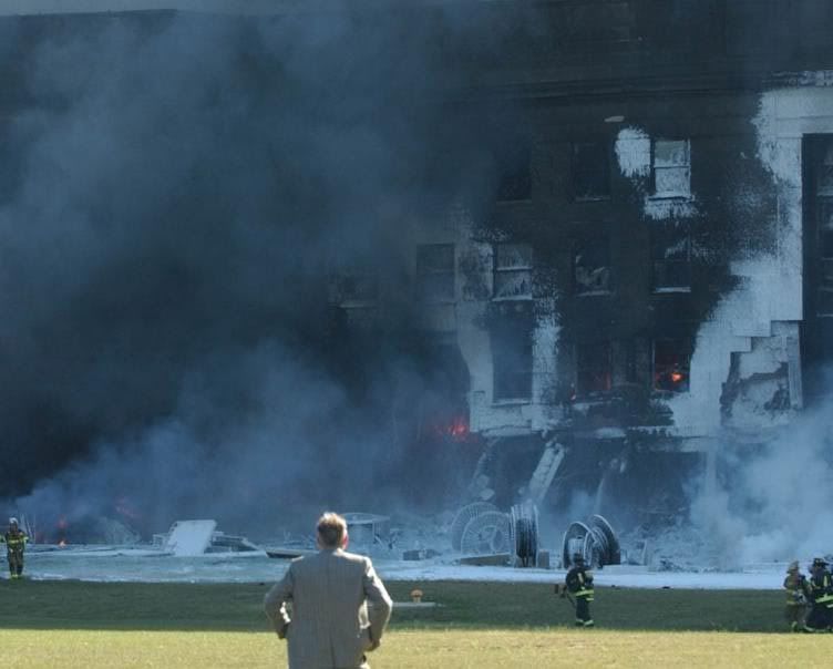
Arlington Topography, Obstacles Make American 77 Final Leg Impossible. Yet again, we hear, some things taken together with other things have again proven the official story of the Pentagon attack is physically impossible. He dated the piece March 13 so he could say dramatically “"Beware The Ides Of March" could not be a more appropriate introduction to this article as it appears the government story regarding the events at the pentagon is officially dead.” Again the merry-go-round spins and in the end… again…. everyone disagrees still. I weary of this game, and this latest seems really a pathetic attempt. But it is in my area and people have asked my opinion, so I guess I need to cover it.

After infinite CIT re-posts of Pilots for Truth misfindings, it seems it was Rob Balsamo’s turn to catch them back. “Thanks to the hard work done by Citizen Investigation Team, they alerted us to review figures regarding topography and obstacles along the flight path of American 77 according to the government story. […] According to the government, American 77 final approach to the pentagon is depicted below.”
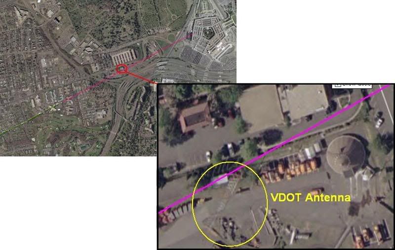
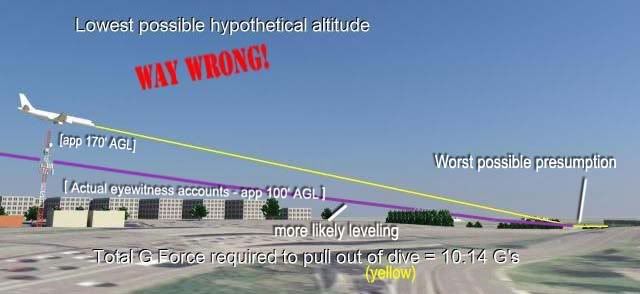
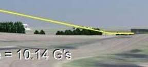
This graphic is not produced by the government, but by Merc Mercy CIT. I’m sure it’s fairly close to accurate, but is it close enough to say where the plane was relative to this 5-foot wide ‘obstacle?’ I’d have to say no. But Balsamo acts as if the government had drawn the line that took the plane right into or over this VDOT transmitter tower, 169 ft tall (including 6-foot antennas on top) above a ground elevation of 135 feet. He never explains whether or not this tower WAS hit, just takes a point right above it as a starting point. From this he did a bunch of math, with too many steps it seems to me, and decided that such a descent from above the tower to the light poles and into the building level would require 11.2 Gs of force.

“Conclusion = Impossible for any transport category aircraft to descend from top of VDOT Antenna to top of pole 1 and pull level to "impact hole" as reported by the government story and seen in the DoD "5 Frames Video". 11.2 G's was never recorded in the FDR. 11.2 G's would rip the aircraft apart.”

I don’t intend to get into the math of all this, but John Farmer’s response is worthy of note: Mission impossible He found that Balsamo’s numbers didn’t add up to what he said they did, double-checked and found the g-force would be 3.5, not 11.2. “So “impossible” is not the word I would use Rob.”

Then he also passed on the video interview of witness Ed Paik explaining how the antenna on top was indeed damaged. Somehow this was not included in Balsamo’s post even though his sources were there when Paik said this. Ranke had to add after that indeed Paik said this but, as Ranke explained back in 2006 “he just deduced this because he saw them working on it the next day. We confirmed with the VDOT employees that the antenna was not clipped.”

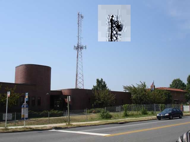
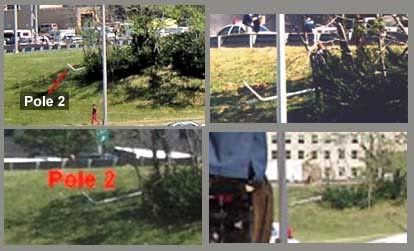
This maintenance was routine then, and just happened to occur one day after the plane flew right over it. Says CIT. Perhaps… But doubts remain; the only photo anyone’s yet found that shows the tower on 9/11 after the strike, by Steve Riskus, shows some hints of a damaged antenna, as Farmer discovered. I can see this, the deformation of the shorter right spire, and it's an intriguing possibility; as Arabesque puts it:

""We have a plane that many witnessed flying by the area the previous day. We have the flight data recorder suggesting that the plane might very well have been in line to hit the top of the tower and continue its trajectory; impacting the light poles and the Pentagon. We have a witness who confirms that the plane was flying at the approximate height of this tower and that he suspected that it was damaged from an impact with the plane as it was being repaired the next day--the two meter antenna replaced by a repair-man. If it can be proven that the tower was damaged from the incoming plane, this would be another compelling piece of evidence for the south of CITGO gas station approach and impact into the Pentagon; corroborated by the flight data recorder no less.""[e-mail]

However, this photo is just not clear enough for me. It’s essentially a needle in the distance, lost in a digital haystack. Any slight artifact will warp it too easily. In fact when people were TRYING to take a good picture in 2006, it almost looks like one antenna is missing entirely (below). I don’t think we’ll ever see a picture clear enough to say unless it was taken by the repairman, but I'd need to see better evidence it was NOT damaged before I'd believe that either (a copy of the work order for 9/12 stating the reason for the repair, for example). I’m leaving this aspect ambiguously undecided and moving on.
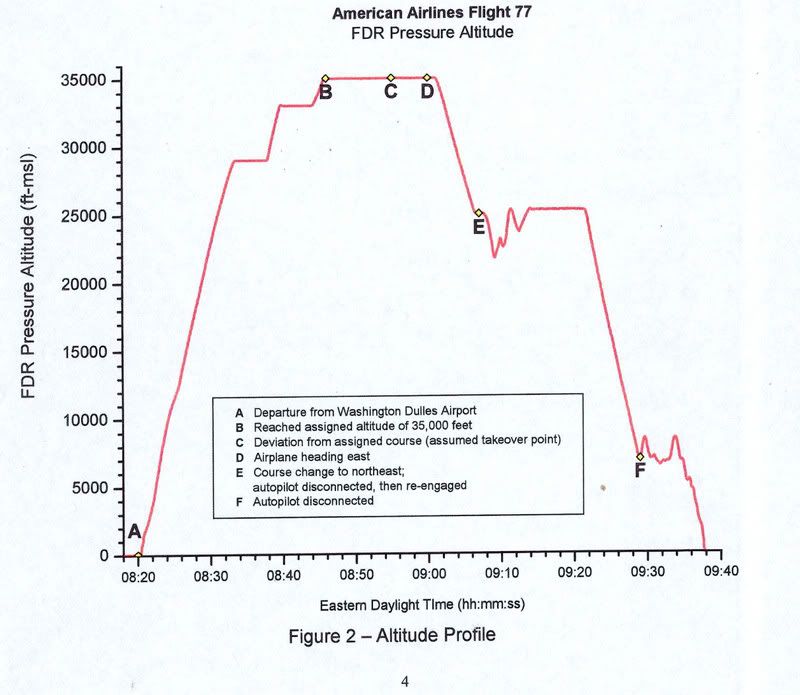
Whether the plane flew just over this spindly 'obstacle' or nicked its top, the descent issues are roughly the same - a descent from 305ft MSL to about 35-40, a total non-linear descent of 270 feet over a span of about 3400 feet. This means a descent of 165 feet from FDR last frame before the antenna and another app. 235 feet dropped from the antenna to the first light pole in the same rough distance but at higher speed. I'm no pilot, but a lower altitude at the tower makes a bit more sense.

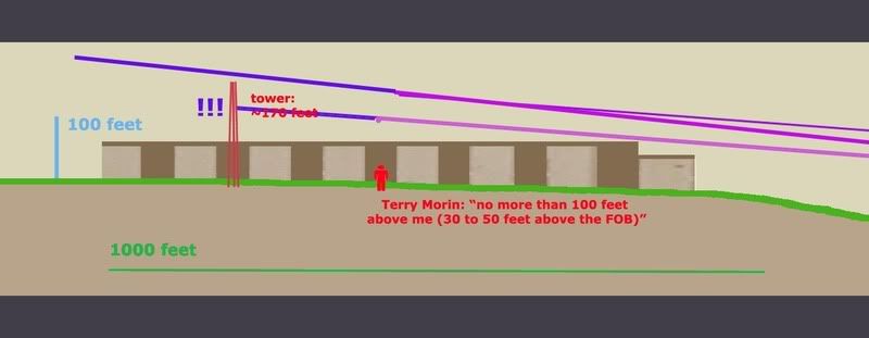
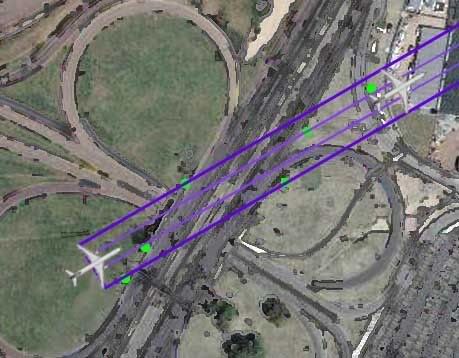
For a different aspect on aircraft height, Terry Morin at the Navy Annex (aka FOB) placed the Boeing “essentially right over the top of me and the outer portion of the FOB (flight path parallel the outer edge of the FOB). Everything was shaking and vibrating, including the ground. I estimate that the aircraft was no more than 100 feet above me (30 to 50 feet above the FOB) in a slight nose down attitude.” For this I’ll us a graphic I used earlier when CIT argued a similar problem relating to descent angles and impossible stuff, just updated a bit. It’s a panoramic graphic so here’s the right half with a reasonable descent angle to the light poles and impact.

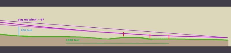
And here is the important half, with the tower added to scale and cross-sectional placement. Oddly, my previous lines extended back take it over the tower neatly, but that’s a pretty steep descent. It looks like it would cause 3.5-11.2 Gs, considering the range offered so far. If we take Morin’s account as closer, which I tend to, it had to be much lower, which offers a more reasonable pitch, but takes the plane well below the top of the tower. This means an impact if Merc’s government line is accurate.

But I doubt it is. Flight paths aren't perfectly straight. They wiggle a bit, especially I would think at high speeds in the lower atmosphere. In another post I established that the witness record and physical damage best fits with a moderate left bank over the Navy annex, and likely a slight left curve to the flight path between the Navy Annex and Route 27 where it leveled slightly, with an apparent left bank of about –5-6° evident in the impact damage.

So considering all we know here is a proposal I offer: I had first favored the purple swerve, but after reviewing Morin I'm betting on the green line at the moment, or else the purple one.
- Final trajectory by pole and building damage - ≈ 61°
- Final FDR heading ≈ 59.9° (these are shown in red at the corners).
- The big yellow dot at lower left is the last reported position in the FDR data we have
- The yellow line a straight shot from there to the damage path. This indeed crosses over or within a few feet of the tower, probably too close for comfort if it weren’t high enough.
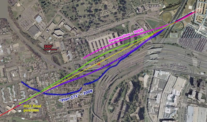
Before going graphically away from straight lines, I added for comparison two non-straight attempts to explain the ‘official’ evidence. In magenta a 2004 estimate by Jean-Pierre Desmoulins with a notable wiggle to it. He’s a pilot. Also in dark blue is an estimate by “Plan 271,” based on eyewitness reports from Dawn Vignola.

The two variations I’ve traced in green and purple are the most moderate explanations. While the green path fits best with Morin's account, the purple one is perhaps more consistent with left bank clues. Note the scale here – 500 feet is just a short line - and that each path is traced along the fuselage centerline. To clear the tower north or south it need only pass 62 feet away (124-foot wingspan). On closer inspection they pass about 250 feet from the tower, so I could’ve made them much milder. In fact I'm thinking the best fit is about 1/3 from the yellow line to the green one, with perhaps a left turn starting earlier, just after the tower, giving it a noticeable left tilt as it approached Route 27.

But even this extreme, both visibly look possible and reasonable – connecting two nearly identical trajectories with a gentle curve away and back, and still safely north or south of the tower. Altitude options open up. Either way, it looks like a reasonable avoidance procedure of a minor object on the attack path. if it were that low, which the witnesses and FDR seem to indicate.

Purple swerve - Max angle required to avoid the tower ≈ 68°
Min angle required to avoid the tower ≈ 53°
Green swerve - about the same
Time frame: app 6-7 seconds from the yellow dot
Any pilots? How impossible is that?

This is a non-issue – a needle of an obstacle that would be missed almost by definition if the path were anything other than perfectly straight, which it probably was. It’s also a non-issue because all previous attempts to ‘prove the official story impossible’ have failed under the test of verification. All that’s happening here is the wrong data being looked at the wrong way and attributed back to reality in a repeated straw man maneuver that’s giving many a case of hay fever. There is nothing impossible about what happened, and as a relative non-issue that seems prohibitively tedious to either prove or debunk I’m not even taking this one to the forums.
Update 3/23:
I took it to the forums a little. 9/11 Blogger (comments page 2) - Above Top Secret.com

update 3/19:

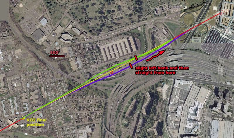
note: in the graphic above I somehow screwed up the 500' scale, making it actually represent about 400 feet. Luckily my margin was still wide enough that these mild swerves are still a fit, both passing well over 100 feet from the antenna tower.

update 3/21:
I just located again Russell Pickering's take on Paik's antenna memories from the old old LCF, 9/10/06:

"I went to the VDOT to confirm it hadn't been hit. It had not. Then in Edward's interview I asked him if he actually saw it hit the tower and he said no. Then I asked him if it hit the solid metal part of the tower and he said no. What he said was that it hit a smaller antenna of 2-3 meters in length on the top. He ended up telling us the reason he thought it had been hit was because he saw somebody up on the tower working the next day.

What had happened then is he incorporated a conclusion from something he saw later into his memory of the original account. The real story is that when the FBI took over the VDOT as a command post they added antennas to the tower for communication."
[emph. mine]

So it actually was not a coincidence people were up there the day after a plane flew by there. There was a direct cause and effect relationship between the two, as that plane had turned the area into a major hurking crime scene of the utmost national security importance. They needed many things, including communications. And perhaps the old antenna was also coincidentally damaged by the plane and replaced at the same time. That certainly can't be ruled out and in fact may well be the case judging by the new evidence coming to light. And that would certainly be another problem for the north path fly over story.

Update 3/23: CIT's take was not coincidence of antenna work but rather that it was not damage-related. They seem the feel it was the military, not the FBI, who put up the new antenna. And we have further confirmation that it was not damaged: John Farmer has confirmed the fact again with the VDOT smart center manager. He offered no details beyond "that was not true!," but as Farmer noted "if anyone should know it would be him (he would have to approve the replacement cost since he was the manager)." [e-mail]

Wednesday, January 9, 2008

VENT STRUCTURE DAMAGE

VENT STRUCTURE DAMAGE
Adam Larson / Caustic Logic
The Frustrating Fraud
January 1 2008
Updated Jan 15, 1am


Among the low-lying evidence of a 757 strike at the Pentagon, as illustrated in this graphic from the ASCE's Building Performance Report, is a 50x30 foot ventilation/exhaust structure, presumably just renovated along with the rest of wedge one it was set about 75 feet away from. Joined to the building by underground tubes, and populated with multiple sub-structures, this area was directly beneath the left engine's purported low-level path of destruction. The vent structure is recessed, set into a slight hillock of that curiously unmarked lawn, so it might seem odd this is where the one part of the plane truly inches above the ground would leave a mark. It is effectively invisible in many long shots except as a pair of doors propped against each other, as in this Jason Ingersoll shot below. The area is surrounded by a low concrete lip, perhaps two feet high at its east side, and having suffered damage to the south wall (the left side above, the remaining portion visible as a wedge near the cable spool).
Up close and prior to foam application, in this cropped section of a Darryl Donley picture, we can see the south wall more clearly. The missing portion of wall is not inconsistent with the bottom edge of a 757-scale engine. To its left is the broken helicopter locator light, one at each west corner of the structure, and apparently both broken. Much of what lies beyond that here is in the further background, but the squared metal structure piled with burning debris is worthy of note - it almost looks like a miniature dumpster already filled with debris.

This valuable photo presented by Jean-Pierre Desmoulins (white labels are his), taken days later during the clean-up, and seen from above shows the south wall damage, lack of something, a naked squarish footprint surrounded by plywood at the entry corner (lower right). It also shows the lack of a back (west) wall, although it seems to cleanly gone, and I'm wondering if there ever was one. The 'doors' are still propped open but the whole unit at a different overall position and angle than seen earlier. The side facing the camera, on its far end, seems to be missing a corner, or is perhaps curved. Keep this in mind. Also note the labeled pile of debris to the right, including it seems that dumspter-ish thing also moved from its initial post attack position, and possibly piled with more debris from elsewhere. I've drawn on a sample plane trajectory (not verified as 'official' but it'll be close) that helps illustrate how both were moved, first by the plane/event, then again during cleanup. The possible limited foundation damage I've located, a foot or three below this, is also along the same line implied by the damage within the vent structure.

Here are some useful very close-ups of the doors, from three Ingersoll shots, in which it's clear they are propped open by a rectangular object off-cenetered between them (green-gray). Note different lip styles on each door, apparently designed for inter-locking, and a long section of black molding hanging off the left door at a smal bit of missing far corner(?). Note the hinge arm thing and possible power cables hanging under the right door. Hinge arm, unclear half-tube shape and more cables hanging under the left. In the top shot note also in the background a tipped Bobcat dozer/forklift, a possible clue to what was going on there at impact time. In the bottom shot note a pile of dark stuff on the right door, the 'grime line' previously discussed, and faintly the broken, bent section of lip, which is revealed as well in this Jocelyn Augustino photo from September 17. Note that with the object propping the unit open removed, the left side seems to sag at an odd angle.


This Ingersoll shot from after the collapse at 10:15 shows the doors or whatever exactly that structure is, the tops of the intact structures, and what seems to be the top of another higher structure, its right half pushed down and its edge twisted.

Steve Riskus' shots fail to clear this point up, and all shots I've seen show only edge and none show its top. All I can say is it seems to have a top of some size, its edge seems to be bent there, it's set far from the south wall, and at about a 45 degree angle between the two walls rather than square. Shots from as early as the night of September 12 show only the concrete footprint of it bracketed with the wood railing seen during cleanup, and so this photo I found (not sure who took it) seems to be from the late afternoon of 9/11 itself. Though washed out, it offers a unique view of the vent structure where we can see under this lid and also see the edge of its footprint (perspective is tricky here).

Using this and Ingeroll's best shot of the lid edge, I made this composite:

Again the overhead shot with more photo comparisons. Perspective issues can be tricky, and also remember things are moving around in the days after.
The new shot I located showing both the 'scorched debris' and the bent 'door' is a Jocelyn Augustino photo (index no. 1890, available at this link), cropped to save space. Looking at the metal, note the coloration, the perforrated square panels, relatively weak construction, griills and flap - ventilation material, warped and burnt. Then compare the boat-looking panel with the overhead shot of the doors - overall shape, size, color, the curved section, the 'grime line' and upper lip, the angle of a scrape across it leading to the broken, bent lip, all present and proportional. It's unclear if the right door/other half of this structure, or its base, is even there in this shot, but that's the one and that's the curve we have to work with.

I certainly have not seen any reasonable non-plane fakery explanation for this point. concrete, one structure apparently bent and scraped out, and anpther structure spun aside, one of its doors severely deformed. There is certainly no simple bomb that will do this, this would have to be arranged elaborately in advance.

Thursday, November 29, 2007

LIGHT POLE ANALYSIS: POLES ONE AND TWO

LIGHT POLE ANALYSIS: POLES ONE AND TWO
Adam Larson / Caustic Logic
The Frustrating Fraud
November 29 2007
working copy update 11.30 1 am


The first two light poles of the five downed in the Pentagon attack were along the west side of Route 27, about 1000 feet from impact. Note here (graphic quite approximate, will be replaced soon) three green dots along the width of the flight path: pole 2 furthest north, pole 1, then a VDOT traffic camera pole that was left standing but suffered a superficial 'smudge,' presumably from the right wing tip. Effective wingspan across this line is approximately 210 feet. My intent here is to determine what I can about pole 1 and 2 damage to help me determine effective roll (wing bank) at that point, or what the fakery was trying to show, take your pick.

Pole 2
First, let's look at pole 2, the least clearly seen of the five downed. Russell Pickering's analysis at Pentagon Research.com compiled the few shots with it visible, peeking out from behind the bushes on the left side of the bridge mound. As this montage I made of the avaiable shots shows, this almost looks slender enough to be the smaller truss arm that holds the lamp head, or more likely the pole itself – its narrow upper end. The left wing would have hit it, and much too low to have directly caused that bend – presumably a secondary effect. There are no photos I'm aware of showing the main damage anything like what the other poles show.

Update: A previously unseen photo I ran across later may hold a clue to this pole, and vice-versa.

Pole 1
The first pole downed, numbered 076, is the famous pole that is said to have speared Lloyd England's taxi windshield, covered in some detail at Pentagon Research.com. There is much, much written about this case - the inconsistencies in Lloyd's story, the damage inside the car and to his windshield, the lack of corroboration for his take that this long pole segment was completley sticking out of his car and was then removed by himself and a silent stranger. Most people who look into the case decide the story does not add up, but there are different theories as to what actually happened and to the significance of this mystery.

Update: It seems by a closer look at the damage to the cab that Lloyd's story is not as unlikely as I had thought.

There are also smaller parts visible (top shot, left: truss arm and lamphead, as well as another small straight piece further to the left, but for now I'm interested in the length of this prime piece of history; the '40 foot pole' that could not have fit in the cab – how long is it really? Unfortunately I can only get a range on original pole dimensions; Pickering says 28 feet, other say 30, and some say 40. After measuring photos back and forth with different numbers, ratios, I’ve decided on these proportions as a best fit, though still approximate:
Pole height: 32 feet
Base height: 16 inches
Full height to cap: 33.333 feet
Pole diameter at base: 8 inches
I also found the proportions of 1990s model Lincoln Town Car, which this seems to be: 77x219.” With al this, rough ratios were set, roughly averaged, estimated, and the apparent length of fragment on the roadway is 20-23 feet - perhaps a bit longer - about 14-16 feet of that straight.


It's probably not even new, but I've decided the part of pole 1 seen by Lloyd's cab is about 20-23 feet long, missing perhaps ten feet off the top, including the parts where the truss bolts down. Where that top part wound up is something I haven't looked into, but they could be simply the pieces on the road nearby, depending if the straight piece measure out right. It's also possible that a sizable chunk disappeared into the jet's engine (see below), causing the gray smoke visible trailing behind Flight 77 at impact.


This graphic, based on another light pole in the area, shows two impact scenarios that geometrically could explain the damage seen, including that unique bend, and the separation of the two parts. I'm not sure kinetically and forensically if either makes sense, just throwing it out there.


Attack Profile: How The Poles Fit In

Putting pole 1's damage into a larger framework that's half-done. While pole 2 is inconclusive, pole 1 damage - a curve and a shear - fits other clues as to the plane's altiude and right-high bank at that point. effective wingspan cutting across Route 27 – 205-215 feet – poles about 140 feet apart – I placed the light poles approximately into a graphic I was working with – between the camera mast scuff and tree damage alone I had a pretty good image of the plane. As it turns out a scaled 757 profile does fit. And the poles don't really mess it up. Perhaps I placed pole 1 a bit wrong, or underestimated the perspective a tad, because the bend of the pole also corresponds roughly with the engine's lower edge. All these points line up to have pole 2 clipped by the outer left wingtip 14-16 feet above ground, and give the plane about the same bank recorded in the damaged facade one second later as well as the generator, fence, retaining wall, and possibly foundation damage between.

Thursday, August 16, 2007

CSV/ANIMATION ALTITUDE DISCREPANCY

CSV/ANIMATION INITIAL ALTITUDE DISCREPANCY
Adam Larson / Caustic Logic
The Frustrating Fraud
August 16 2007
last updated 8/21


Note: Pilots for Truth senior member “Undertow,” who I admit has far more knowledge in this area than I, commented on the following piece “You can not possibly be this moronic about this. Please for the love of god stop confusing everyone.” (see comments below)

I read this as his seeing too many mistakes to be accidental, and so it’s probably an attempt to confuse, a feeling I'm familiar enough with. No, in fact, I can be, and was, this moronic. I am off on a lotta spots here, numbers and otherwise. Sorry, I was tired and inspired at the same time. The general gist is still right, but numerous minor alterations and further notes are to come… (in red) Apologies for any remaining confusion and please don’t take this as a final word on anything without consulting a non-obfuscationist expert first. In fact I'm not even saying much at all here.

But as “mod” says below “CL is going in the right direction IMHO. What does the Video say vs. the CSV file, in terms of pure numbers? 99% should match.” I also feel I’m onto something here or I wouldn’t’ve posted it… I just don’t know what yet. Maybe it’s nothing. But UT’s vehemence has inspired me: “Jesus, please stop and really think about this before posting anymore absolute nonsense.” Have done, and I got lots of red here now. Jesus. I'm done.

For more in-depth, piloty, and udeful analysis of pressure altitude readings, please see the lively and enlightened Pilots for Truth discussion thread at this link. Hopefully you're a member, or perhaps they'll provide me with a better link to help explain what I'm missing here. Otherwise do your own research or just hang tight to see what I come up with.
---
Where I was Wrong
Aha! I feel stupid but not really. I had previously concluded that the original, takeoff altitude for Flight 77 in the csv fille matched the same in the NTSB animation. It turns out I was incorrect. It was a mistake on my part but kind of odd how easily it lent itself to misreading.

1) The actual altitude at Dulles is about 300 ft msl as I’d heard. I verified this with Earthtools; runway 30 is on an slight uphill slope from about 285-295 feet MSL. I’ll call it 290.

2) The NTSB animation shows precisely 300 feet in the altitude dial on the ground. It’s not quite right, but close enough to be accurate. It also happens to match almost exactly the magnetic heading on that runway of 300 degrees from magnetic north, also displayed as 302 with the plane at rest.

The csv agrees on mag heading and lists it as 302 for the long runway pause, which is where I got mixed up. When I first dug in for altitudes, I saw it was luckily only the fifth of several hundred settings so would be easy enough to find. I had heard takeoff altitudes matched, so looked first for an altitude of about 300, I counted over five, six, whatever values and saw 302. Not realizing it was actually the mag heading, I took it as a verification of the animation’s rough accuracy. The reason I missed the actual pressure altitude is that it’s unusually different from the display alt at that point, while the mag heading is still much closer, if it were altitude in feet. And they’re listed right next to each other so I got mixed up.

In fact the beginning altitude listed in the csv is 40 feet, 250 feet too low to be accurate. This is a point of disagreement I haven’t heard anyone mention yet, though Undertow tells me I’m “covering ground which we plowed last summer.”

Tho it didn't come across as I noted a discrepancy, I do also understand the csv and animation attitudes should not exactly match – as UT usefully points out “The FDR produces a Pressure Alt and Baro column in the CSV. Together they create what the pilot would see on the Actual Alitmeter. Which is what is supposed to be shown in the Animation.” That is, the pressure alt reading “+” barometer correction = real altitude. The exact relation and expected differences I’m not totally clear on but getting there [another post]. What I'm really noting here is a massive difference I hadn't noticed before, apparently the mirror image of the 300-foot part of John Doe X's correction.

Tracking Back
I stumbled on this error while looking into another, related anomaly, a search that involved lots of backtracking. I saw that the final altitudes at 9:37:44 are near identical – 180 for the animation’s dial and 173 for the csv (of course they aren’t supposed to be, because of the omitted barometer reset). This final altitude is however misleading, and seems to be from a frame of data that didn’t play out and would have left the animation considerably lower. In the four seconds before that, the two reading carried a rapidly decreasing difference of 50 feet to 28 feet, with the animation lower. I didn’t bother tracking this discrepancy, but noted that they match up closer back around 9:24 (animation about 15-20 feet lower than the csv), both before and after the mysterious FL180 reset recorded in the csv that had no effect on the animation readout.

So clearly the altitude difference between the two is all across the board, but nothing in the difference range of hundreds of feet. Tracing back further, they also match roughly after the initial FL180 reset on ascent (at 8:28) with difference of 20-30 feet but with the animation higher this time. Since it reads lower near the end, there is a roughly 75-foot fudge room, at least, between the two, that comes in somewhere between 8:28 and 9:24. I don’t feel like tracking this down, especially since I had been looking for something else.

An Inexplicable 240-foot Gap
At the initial FL180 reset, on ascent, at 8:28, Pandora’s Black Box shows an altitude drop from 18273 to 18058, a difference of 215 feet. Despite having matched the csv before that (I thought) and after being only about 27 feet off. There is 242 feet of total discrepancy here, most of which is lost at 8:28 leaving a near-match after, which means the animation must’ve been set much higher than the csv before the change. Another error of the cartoon, no doubt.

I’d never noted it before, but lo and behold, the altitudes do not match before that onscreen drop. The difference is in fact about 280 feet, animation high. Since I “knew” they matched on the runway at 8:20, I traced it back over the intervening eight minutes to see where the discrepancy crept in. Actually I started at the beginning and made the same mistake of identifying 300 and then watched for the up-tick to match the animation after it started rising at 8:20:16. I suspected the csv would be slower, but it remained at about 300 all-down the 300-oriented runway second after second as the animated plane rose. Then I realized I was looking at the wrong column, that the discrepancy runs back to the first frames and the csv file’s original altitude is wrong – to the tune of 250 feet underground, the same discrepancy nearly erased with the onscreen altitude change (leaving as the remainder the smaller discrepancy).

Here is a table of data at the relevant points: "baro cor" is the setting re-set at 18,000 feet both ways, once apparently by Capt. Burlingame, once by capt. Hanjour. + differences mean animation high, - means csv higher than animation.
time |baro cor | anim alt | csv alt | diff.
8:20:15 | -- | 300 | 59 |+241
8:20:16 | 30.20 | 304 | 52 |+252
8:20:17 | -- | 311 | 49 | +262
8:20:18 | 30.21 | 323 | 53 | +270
8:20:19 | -- | 339 | 61 | +278
8:20:20 | 30.20 | 363 | 83 | +280
8:20:21 | -- | 392 | 111 | +281
8:20:22 | 30.21 | 420 | 144 | +276
8:20:23 | -- | 456 180 +276
8:20:24 30.20 494 210 +284
8:20:25 -- 530 248 +231
8:20:26 30.21 568 290 +278
8:20:27 -- 614 330 +284
8:20:28 30.20 662 372 +290
8:20:29 -- 704 417 +287
8:20:30 | 30.21 | 755 | 469 |+ 286

8:27:54 | 30.21 | 18081 | 17785 |+296
8:27:55 | -- | 18129 | 17823 |+306
8:27:56 29.91 18140 17861 +279
8:27:57 -- 18179 17899 +280
8:27:58 30.21 18219 17938 +280
8:27:59 -- 18252 17976 +276
8:28:00 29.91 18166 18015 +151
2:28:01 -- 18083 18056 +27
8:28:02 30.21 18118 18093 +25
8:28:04 29.91 18198 18170 +29
8:28:06 | 29.94 | 18278 | 18247 | +30
… …
9:24:10 | 29.92 | 18264 | 18285 | -21
9:24:11 --- 18222 18245 -23
9:24:12 29.91 18185 18205 -20
9:24:13 -- 18151 18168 -17
9:24:14 29.92 18106 18126 -20
9:24:15 -- 18071 18088 -17
9:24:16 30.23 18030 18049 -19
9:24:17 -- 17993 18011 -18
9:24:18 | 30.01 | 17956 | 17972 | -16
… ... ...
9:37:40 | 30.23 | 445 | 496 | -51
9:37:41 --- 351 399 -48
9:37:42 30.24 279 307 -28
9:37:43 --- 211 239 -28
9:37:44 | 30.23 | 180 | 173 | +7
---
Here is the graph of five seconds at each of the four key spots. One can see how a roughly 300-foot jump in the animation altitude (red) would be expected at the second re-set. I'm not sure what exactly to make of this, this is just to illustrate. (view in new window to see it full-size)

Clearly, there is a massive discrepancy only for the first eight minutes of flight and back on the runway. So this piece stands as two points:

1) I correct myself on a silly mistake – the initial csv altitude I had previously worked with was grossly wrong
2) Whether or not they should, the animation dispaly and csv pressure altitudes roughly match all through the flight, as I have previously noted, except for these first eight minutes.

And since I just now figured this out I don’t want to say what it means – if the JDX correction is boosted by this or if this reveals something else. That's in the math I'll do a bit later. But it cleary raises questions about the data itself, if not about what physically happened.

Friday, July 20, 2007

FINAL ALTITUDE: EIGHT READINGS

FINAL ALTITUDE: EIGHT READINGS
Adam Larson / Caustic Logic
The Frustrating Fraud
July 19 2007
updated 8/12


Note1: I’m not precisely certain on ground level altitude at the Pentagon, but it seems to be in the range of about 35-40 feet above mean Sea level (ft msl), so to keep the math simple I’ve rounded it to 40. The discrepancy should be no more than five feet from reality.

Note 2: Possible explanation for pressure altitude errors: airspeed at least has been known to effect this reading, and from what I hear, errors in the range of 100 feet or more are not uncommon. This consideration is relevant for the different pressure altimeter readings in possibilities 2, 3, 5, 6, and 7.

1) Official story/physical evidence/eyewitness reports of impact: these multi-corroborated sources indicate the Pentagon attack plane’s belly was about 5 feet above ground, or about 45 ft msl. A majority of the fuselage impacted just beneath the second floor slab, with left engine and perhaps wingtip in fact hitting objects at ground level. (Source: reality or mind-boggling fakery)

2) Specialist’s Factual Report of Investigation (SFRI): Final alt is unsure – seems near zero but the graph resolution is not high enough to read precisely. In general contours it matches perfectly the more detailed Flight Path Study. (Source: straight from NTSB)

3) Flight Path Study graphing: Still not precisely clear - FDR pressure altitude measured in ft-msl. Lowest graph division is 1,000 feet – Pentagon impact seems to be about zero feet MSL, close to its actual elevation of 40 ft msl. However the Dulles takeoff at about 300 msl, 260 feet higher than the Pentagon, also charts out at what seems zero ft msl, or 300 feet underground? (Source: straight from NTSB - click to enlarge graphic)

4) The PentaCon reading of their eyewitnesses: 100% of their witnesses colse enough to see were convinced of an impact, but various clues indicate a flyover, At least 74 feet above ground level (agl), or 114 ft msl, or the lowest possible level above the roof. The range above that is theoretically limitless, but the lower the altitude, the more likely it could be mistaken by witnesses as an impact with the 73-foot-high building. The higher the altitude, the less sense the flyover theory makes. (Source: Citizen’s Investigative Team)

5) AAl_77.tab, tabular CSV file: final frame altitude of 173 msl, again pressure altitude - sixty feet over the buildin'g roofline. Takeoff alt was at correct elevation for Dulles airport of 300. The CSV file also shows a manual reset of the pressure altimeter at 18,000 feet on descent into the attack, as per FAA regulations, with no apparent effect on recorded pressure alt settings. (Source: NTSB via P49T member Undertow - I need to post my analysis on this soon)

6) The animation, uncorrected, has it 140 feet above ground at the end, somewhat lower at “impact point” if the trends were to continue, but certainly too high to have clipped the poles, hit the generator, or impacted the building. The closeness of this to the CSV indicates the animation was based on pressure altitude – especially with no operative radio altimeter. (source: NTSB via Snowygrouch, then SLOB, Mitch Harrison, etc. – link coming)

7) Read Out 2: An anonymous and irreproducable decoding of the unreadable L3 raw file reveals the nonexistent radio altimeter shows a 270 foot altitude above ground level (agl) at the end. This reading is based on signals bounced from the ground and not subject to pressure alt errors. Radio altimeter is listed in SFRI as inoperative and left blank. Snowygrouch says the reading “had been omitted by the NTSB […] for reasons known only to themselves,” even though it was “precisely the same as the pressure altitude.” It isn’t. (See readings 2, 3, 5, 6) (Source: it’s complicated – the story is here.)

8) John Doe X corrected: When the animation’s final altitude is adjusted to reflect the pressure reset not shown in the animation, the plane is 480 ft msl, 440 ft agl, and 367 ft above the Pentagon’s roof. This is probably too high to have been seen by witnesses at all, and far too high to have been mistaken for an impact. (Source: Animation plus JDX calculations)

Clearly not all of these six altitudes can be correct, though it’s not right to say only one is. Some may corroborate each other, like the animation and CSV, or official and CSV if the alt error was high enough. But to corroborate the PentaCon witness reading, it’d have to be just above the Pentagon roof, and well below that to support the official impact story; there was no high-impact “near-flyover.” It hit low or it didn’t hit.

But this is the only altitude of the eight that also allows the plane to strike the building - matching the (faked?) CCTV video footage, the (fooled?) closest eyewitnesses, the PentaCon’s own (duped?) witnesses, the (planted?) clipped poles and (engineered?) lawn-area damage, the (faked?) 300-foot deep damage to the Pentagon, the (planted?) 757 parts, etc. All these, taken collectively as reality (a leap some are unwilling to take), rule out any altitude higher than the official one. Readings 2, 3, 5, and 6 all could possibly correspond with this, due to the common errors of pressure altimeters, but certainly NTSB data seeming to place the plane well above the roof is problematic.

The higher readings each rule out all of this evidence and each other, and are supported precisely by themselves; another reading with no other backing. There may be more readings yet to come – say, 375 ft msl, or 30,000. That’d be new.

Monday, May 7, 2007

THE UNMARKED PENTALAWN

Adam Larson/Caustic Logic
The Frustrating Fraud
Updated 5/7/07


One of the most persistently-used evidentiary leadups to no-757 claims is the Pentagon's lawn, showing narry a scratch in the photographic record despite the massive Boeing 757 that had just passed inches over it and exploded. Myriad revisionists have pointed to early eyewitness accounts that had the giant Flight 77 skimming and then actually hitting the grass before it actually hit the Pentagon’s façade. For example, Tim Timmerman reported "I saw it hit right in front of -- it didn't appear to crash into the building; most of the energy was dissipated in hitting the ground, but I saw the nose break up, I saw the wings fly forward, and then the conflagration engulfed everything in flames. [...] it was right before impact, and I saw the airplane just disintegrate and blow up into a huge ball of flames." CBS News reported onSeptember 26 “some eyewitnesses believe the plane actually hit the ground at the base of the Pentagon first, and then skidded into the building. Investigators say that's a possibility.” How so? All photos and video from the day of the attack have shown the same unmarked lawn seen below.


Time, September 12: “There is a helicopter pad right in front of the side of the Pentagon. The wing touched there, then the plane cartwheeled into the building.” ESPN, September 12, referring to other accounts: “What - or who - caused Flight 77 to hit ground first, diffusing most of its destructive energy before it slammed into the Pentagon?” They seemed to be hinting it was heroes on board, like with Flight 93, who helped grind the plane into the ground to weaken its impact. The turf, as I’ve seen it, shows no such evidence of heroism. Besides Loose Change, 911 In Plane Site points this out with glee, and it’s been marveled over by Killtown as the miraculously resilient “Pentalwan 2000.”

Actually, there is some truth to the stories of the plane hitting the ground. It was flying remarkably low, with its port (left) wing tilted lowest. Looking along the flight path, explained in another post, this would indeed put the wingtip near or in the dirt not far from the helipad (in front of the small building at left is top picture). Below we can see where the underhanging left engine may well have nicked a low retaining wall around an exhaust structure about 100 feet from the impact site, and may have scraped some sod there as well. However, grass damage appears questionable even here, and over the vast expanse of the lawn, especially seen from a distance and far to the right as usually shown, indeed, there are no meaningful marks. This is undeniable, but even without that damaged wall, it's also another red herring tossed on the pile rotting in the sun of over-scrutiny. The official plane never did hit the ground in a real way. The no-planer’s missile never touched the ground. Even if it was blowing up just before impact as Timmerman and some evidence indicates, Nothing touched the ground, except at that one spot. So we all agree, let’s move on. Harping on this point proves nothing but a few mistaken witnesses who had after all just seen a massive jet descend from the sky to just a few inches off the ground – in their minds they expected a crash with the ground and most were probably too busy diving for cover to watch closely.

As for what the conspiracy theorists see in these mistaken accounts, some see in it the impossibility of flunky pilot Hani Hanjour NOT hitting the ground and suspect precision remote control - I find this likely myself. But others of the Loose Change variety perhaps see a clue that the Pentagon was pressuring people to lie about what they saw, and (ironically?) as the reported gouges in the lawn evaporated, so too did the reported plane for the Dave Von Kleists and Dylan Averies of the world. Perhaps some folks actually were coached to say this despite its instant disprovability as part of a Pentagon-sponsored disinformation campaign for precisely the end of spurring such useless conspiracy theories. Otherwise, I'm guessing they just thought it hit the ground.

Tuesday, April 10, 2007

PILOT X AND THE 440 FOOT GAP

FLIGHT 77 ALTITUDE QUESTIONS
Adam Larson
Caustic Logic / The Frustrating Fraud
April 9 2007
last edited 4/15 @ 9:32 pm


In mid-2006, new doubts about the five-year-old Pentagon attack were found, built right into a government-produced animated flight path of AA Flight 77. The group Pilots For 9/11 Truth (P49T) have been able to capitalize on the inherent contradictions in this CG cartoon - most notably in their January 2007 video Pandora’s Black Box Chapter Two - to somewhat convincingly suggest an entirely new flight path that in different (and often contradictory) ways, disproved the official flight path and, if correct, make the plane’s impact a steep improbability. [I'm working on more detailed posts about both sources and discrepancies]. The latitudinal aspect of the new 757 denial trajectory, the apparent flight well to the north of the official path, is one anomaly in this animation, but will be covered elsewhere. Here we’ll focus on the altitude questions, which are, no pun intended, a little over my head and the heads of others, a fact that at least one side in the debate seems to be using to its advantage.

The animated video file was based on the flight data recorder (FDR) of the doomed 757, rendered by the National Transportation Safety Board (NTSB), and released in mid-August 2006 via a FOIA request by a P49T-affiliated researcher. By August 20, P49T co-founder Rob Balsamo (aka John Doe X) had come into possession of the damning flight simulation and wrote about it at the group’s site. The final frame was key: it shows the animation stopping abruptly, as the original data supposedly did, with the plane on-screen still hundreds of feet away from the Pentagon and still far above it. Time at this location: 9:37:44, the second before the plane is supposed to have hit the building. While at that very second the CCTV camera north of the attack path was snapping a plane cruising in about five feet off the ground, the onscreen altimeter reads 180 feet. The plane in this animation could not have hit the Pentagon, at least not at the official time. It would have been several seconds late by the speed and descent rate up to that point. But it cuts there, at about the right time but quite the wrong place, and we were thus prevented a glimpse of the fly-over, the secret landing, and the safe removal of the FDR to be planted back at the Pentagon. (??) These are the gaps we must fill in to reach the "Truth."


Screenshot of the final frame: The time is ajusted to GMT, not EDT, so 13:37:44 should read as 9:37:44. The resolution here is easier to read than in the low-res video of the final maneuver available for free viewing online here

Balsamo explains: “You will notice in the right margin the altitude of the aircraft on the middle instrument. It shows 180 feet. This altitude has been determined to reflect Pressure altitude as set by 29.92 inHg on the Altimeter. The actual local pressure for DCA at impact time was 30.22 inHg. The error for this discrepancy is 300 feet. Meaning, the actual aircraft altitude was 300 feet higher than indicated at that moment in time. Which means aircraft altitude was 480 feet above sea level.” [1] This is also 440 feet above the ground. Thus “the 5 frames of video captured by the parking gate cam is in direct conflict with the Aircraft Flight Data Recorder information released by the NTSB.” [2]

As John Doe X, Balsamo has put together several long – and lonely - posts explaining this true altitude conclusion at the Pilots’ site, and apparently has been pretty aggressive in promoting and defending it elsewhere. [3] I haven’t been able to independently verify his 300-foot correction, but initially guessed it was quite possibly correct. Either way, there is a re-set protocol; from what I gather of the reason behind this, FAA regulations mandate pilots use local atmospheric pressure settings when in the lower, more crowded airspace – below 18,000 feet (FL180). Above that point they re-set to a baseline pressure setting of 29.92. On its ascent, we're told, both the animation and the other data show Flight 77’s altimeter re-set from local pressure (30.21) to 29.92 at about 8:28 am). Pandora’s Black Box shows an altitude drop at that point from 18273 to 18058, a difference of 215 feet; so a rise of perhaps 300 feet when switching back to a nearly-same presure setting on the descent seems plausible, but the corresponding, FAA-mandated re-set is not shown in the animation, and hence the cover-up.

This may not seem surprising – why would Balsamo suspect there should be such a re-set despite the change of control from FAA-certified pilot to suicide hijacker? The reason he has a problem here, and really its own problem, is the other P49T data, also obtained separately by FOIA request, indeed did show the re-set from 29.92 to 30.23. Balsamo summed up the non-animated data “show[s] the altimeter being set in the baro cor column on the descent through [18,000 feet].” [4] I’ve checked and it does. Taking that as truth, the Pilot(s) asked the government why “the animation altimeter does not show it being set?” The question was rhetorical; the answer they had already decided on was that the omission was to make a strike look somewhat less impossible; “this is a blatant cover-up to confuse the average layman in hopes no one would adjust for local pressure to get True Altitude. Too bad for them we caught it.” [5]

A member at JREF named “Anti-Sophist” who describes himself as an Air Force trained flight data expert and electrical engineer, summed up of "JDX"s 300-foot correction “if his true altitude number is correct, he is actually on to something, […but…] No one seems to agree with his "true altitude" calculation except for him.” [6] To see what effect the "cover-up" had, and to help clear up which impossible altitude seemed more likely, I looked into the Pilots’ comparative data, a CSV file for Excel, called AAL77_Tabular, where the pressure re-sets at 18,000 feet are recorded each way. This document forms the basis of my FL018 research (thread coming), but I have yet not been able to independently verify its authenticity. Oddly enough, the recorded altitude does not change at all with the adjustment and there is no meaningful discrepancy!

Ascent:
time - Hg - alt
8:27:58 30.21 17938
------------------------------ FL180
8:28:00 - 29.91 - 18015
8:28:02 - 30.21 - 18093
8:28:04 - 29.91 - 18170
8:28:06 - 29.94 - 18247
8:28:08 - 29.91 - 18324
8:28:10 - 29.92 - 18402
8:28:12 - 29.91 - 18483

Descent:
time - Hg - alt
9:24:12 - 29.91 - 18205
9:24:14 - 29.92 - 18126
9:24:16 - 30.23 - 18049
------------------------------ FL180
9:24:18 - 30.01 - 17972
9:24:20 - 30.23 - 17895

The pressure was reset at 8:28, with no 300-foot drop in altitude, and re-set on descent, again with no effect. Yet it shows essentially what the "altered" animation shows at termination: 173 feet compared to its 180. [7] So the data here shows two pressure re-sets, 302 feet at takeoff, 173 at the end. The animation shows 300 at takeoff, ONE reset, and 180 at the end. The pilots insist the data and animation match except for "the blatant cover-up" of neglecting the second re-set, turning the data's real alt of 480-ish to 180. But in reality, the animation and this CSV file match from A to Z despite the alleged cover-up and that extra 300 feet is looking like a red herring.

But even without Pilot X’s "correction," a Pentagon attack could not have occurred by a plane that far from the building, and that high, by either the CSV file or the animation. Considering this animation also shows the northern flight path that rules out this plane reaching either the Pentagon or the light poles before it, a whole slew of glitches, or perhaps some other explanation, would be required to debunk this damning NTSB-supplied animation.

One interesting tack is to compare all available sources, check their degrees of authenticity/verifiability, and then compare which comport with which and, as Sesame Street used to urge us, find “which one of these things just doesn’t belong.” There is an investigation of this underway, going very slow so far but it should be up soon.


Sources:
[1], [2] Flight Data Recorder Analysis - Last Second of Data - 09:37:44 08/20/06 http://pilotsfor911truth.org/pentagon.html
[3] John Doe X. Fdr Vertical Speed, Altimeter lag issues addressed as well. Pilots for 9/11 Truth forum: Flight Number: American 77. Posted October 15 2006, 08:41 AM http://z9.invisionfree.com/Pilots_For_Truth/index.php?showtopic=106&st=0&
[4], [5] Questions for the US Govt regarding AA77 Flight Data Recorder. Posting date unlisted
http://pilotsfor911truth.org/pentagon.html
[6] “AA77 FDR Data, Explained.” Posted by: Anti-Sophist. October 13 2006at 9:10 pm. http://forums.randi.org/showthread.php?t=66047
[7] AAL77_Tab - Excel document - downloaded from: http://z9.invisionfree.com/Pilots_For_Truth/index.php?showtopic=64&st=0&

Tuesday, March 6, 2007

FDR 2: THE SPECIALIST'S STUDY

It was there, it was recovered and successfully transcribed, some had access to the data, and the altitude readings from it, at least, were published. But the initial report was not released in the August batch, even as its Flight 93 counterpart was trumpeted. There are no press releases or news accounts on this FDR study, as far as I’ve seen, but it is, after all, available. The NTSB report, like its Flight 93 counterpart, was titled “Specialists’ Factual Report of Investigation: Digital Flight Data Recorder,” and was completed on January 31 2002, shortly before that other report. Like 93’s “specialist study,’ it noted “an examination of the recovered data indicated that the recorder operated normally.”
[direct NTSB PDF download link]
Flight 77 FDR Research Thread I started @ Above Top Secret,: Great insights, explanations, and fumbling.

Two shots from the Specialist’s Study of the very FDR in its casing and in the lab.


The FDR recovered and received on the 14th was a Loral Fairchild model F2100. It used flash memory, could encode 256 12-bit words per second, and hold at least 25 hours of memory. The report broke down all parameters of the plane, every switch and setting each assigned a code. Recovered data was converted from binary form to engineering units via the NTSB’s Recovery Analysis and Presentation System. Of note is the fact that the report included “only validated parameters.” The others “either were not recorded properly or were not confirmed to have been recorded properly.” [p 2] I’m not sure what these parameters were and what effect it may have on the final readings…

Everything else, including speed, heading, and altitude were charted out on the final flight timeline over sixteen pages. Below is page 26.
right-click, new window, for full-screen, readable view.

Airspeed (near bottom, green) near the end was about 300 knots, or roughly 350 mph, but climbs sharply near the end, corresponding with witness accounts of the pilot “gunning it,” appearing to top out at over 550 mph as it slammed into the building. Altitude (near bottom, black): unlike the animation (which has serious alitude questions), it starts and ends evenly at about zero, showing no sudden changes. The red line that descends steadily is weight: one of the few things a plane does steadily is burn fuel...

Perhaps the most interesting is the magnetic Heading line (dark blue, near bottom). This seems to represent direction, though it’s hard to read for sure. It starts out steady west, then switches in the middle to eastbound, the turnaround after the takeover. At the end it goes haywire, apparently the big near-full circle loop – east-south-west-north-northeast, then impact. As for the flight path this represents, it corresponds with the pilots’ video fairly well, but it’s impossible for me to tell from this whether it was north or south of the Citgo.

The “new” flight path seems possible, but it was heading northeast from southwest by this, as the official story maintains, and so seems at least as likely that it came in on the official path and indeed clipped the light poles and caused the building damage. Call it a hunch, or a bias. If I get anything better than that, it’ll of course warrant an update.

Friday, January 12, 2007

PRECISION LOW-RIDER

PRECISION LOW-RIDER
THE UNLIKELY FINAL ALTITUDE
Adam Larson / Caustic Logic
The Frustrating Fraud
Last updated July 21 2007


Perhaps the strongest point still worth considering in the no-plane/Pentagon overflight argument is the suicide pilot’s precise attack, a feat of piloting some have flat-out called impossible for a jetliner, which would crash or fall apart or something under the pressure of what the expoerts call ground effect. Nila Segadevan, for example, found it evident "that it is physically impossible to fly a 200,000-lb airliner 20 feet above the ground at 400 MPH," and presumably even tougher to handle one as low as five feet or less and at speeds topping out at 575, as recorded in the FDR.

The attack craft’s performance as seen by the Washington controllers immediately raised eyebrows of suspicion. As the Washington Post reported the day after the attack how “just as the plane seemed to be on a suicide mission into the White House, the unidentified pilot executed a pivot so tight that it reminded observers of a fighter jet maneuver. The plane circled 270 degrees to the right to approach the Pentagon from the west, whereupon Flight 77 fell below radar level, vanishing from controllers’ screens.” Danielle O'Brien, an air controller at Dulles airport, told ABC News “the speed, the maneuverability, the way that he turned, we all thought in the radar room, all of us experienced air traffic controllers, that that was a military plane. You don't fly a 757 in that manner. It's unsafe.”

But safety apparently wasn’t the top concern; as he closed in, Hani Hanjour (we’re told) got even more bold and decided not to simply nose-dive his missile into the upper part of the fairly squat building (77 feet high in total) but to skim the ground like a hot rod even though it meant clipping light poles as he crossed a freeway (luckily no tall trucks there). In the last couple of hundred yards, he was reportedly flying only a few feet above the crew-cut lawn, and that with the wings wobbling under a deadly combo of high speed and atmospheric pressure, before slamming into the ground floor when he had five to choose from. Coming in so low means the engines would be nearly touching the ground, and any slight banking or upward irregularity in the surface would cause an engine to hit dirt and send the whole thing cart-wheeling into the lawn. Thus in addition to excellent control, Mr. Hanjour must have spent some time studying the exact topography of the Pentagon’s lawn to be sure it wouldn’t foil his daring precision approach with any pesky hillocks.

The ASCE's Pentagon Building Performace Report, for example, reproduced the five frames of security camera footage made public in 2002, seeing in them the approaching aircraft with its top about 20 feet above ground, "so low to the ground that it reportedly clipped an antenna on a vehicle on an adjacent road and severed light posts." Indeed, five poles a few hundred feet from the building were clipped and knocked over, their placement indicating the same wingspan and trajectory reported, as well as the plane's remarkably low altitude. On its path across Pentagon’s lawn, the plane banked with its right wing higher; about 100 feet before impact, the right wing struck a construction generator and the left engine was so low it impacted a “ground-level, external vent structure,” the report notes. These may have led to a pre-impact explosion in which “portions of the wings might have been separated from the fuselage before the aircraft struck the building.”

So while the final approach may not be as perfect as widely believed, it is remrkable, and looks a bit like the work of a precision-guided missile. But after a look at the physical evidence and eyewitness accounts, it looks like a projectile the exact shape, size, weight, paint job, etc. of an American Airlines 757 or similar model. The plane may have had a long life of peaceful flights until re-rigged in its final days, and may well have been filled with the very people we were told it was. Captain Burlingame may well have been running the plane normally at takeoff as we’re told, but lost control as the plane turned around over Ohio, dropped its transponder signal, and closed communications with the outside world. This is far from provable, but well within the realm of possibility. Hani Hanjour, to put it mildly, is not the only pilot in the world who could pull all this off, and whoever or whatever was at the controls, it seems, knew the target very well.