NTSB'S "GOEBBELS" AND ME
Adam Larson / Caustic Logic
The Frustrating Fraud
April 24 2008
Previously I have written on my reasons for contacting the NTSB over Flight 77 FDR data, and on the empty envelope I got for my FOIA pains. But for some reason, I never did post the results of the middle part where I contacted the Safety Board’s Public Affairs dep’t. I did mention it once or twice but have never explained in detail or showed the e-mails. I didn’t include it in my FOIA video, which would have made it even more boring. So it came across like a bit of an ambush when I first posted this stuff at Above Top Secret.com the other day after Rob Balsamo/johndoex said:
“This is almost as good as when CL refused to contact the NTSB when he accused us of fabricating the animation.”
He knows damn well that I contacted them if not the full story. Perhaps he thinks I made it all up. But for the record, I’m still surprised how quickly I contacted them, considering what a procrastinator I usually am. I started my first animation/FDR-centered ATS thread on May 27 last year, with my initial well-founded (but ultimately wrong) doubts over the animation’s authenticity. I first found undeniable evidence of NTSB pedigree late on May 29 (Slob’s video posting at Google), and then found more info over the next few days, which had people saying the ball was in my court - time to try it myself.
Even though it’s not my normal thing, I decide to try a unique approach and start with the public affairs department, hoping to score a ‘media liaison’ to help from the inside. It was on the afternoon of June 6th that I called them and talked to a guy named Ted Lopatkiewicz (it’s pronounce lo-pat-ke-wikz, for those who have a hard time), who I later found is the department director, and whom Balsamo has called 'the Joseph Goebbels of the NTSB.' I don’t know why he answered the phone instead of some subordinate, but not even knowing who he was, I got tongue-tied, and followed up with an e-mail at his request. [I considered recording the call, but figured I’d be even more nervous that way, plus I was trying for the human touch as opposed to the legalistic.] Later that night, I filed an online FOIA request for good form and then fired off an e-mail, sent June 7 at 2:37 am. It read as follows:
---
Director Lopatkiewicz
My name is Adam Larson, the guy with the 9/11 questions who spoke with you briefly yesterday afternoon. I’m not sure it’s normal to have reached the director of the office directly, and I’m a bit embarrassed, so right to the point:
I’m sure you’re used to precise questions, but mine are actually many and varied. They regard the flight data recorder from aircraft no. N644AA, American Airlines Flight 77, that of course hit the Pentagon on September 11 2001. I’ve been researching the subject for quite a while, starting as a “conspiracy theorist” looking into what I first thought were silly claims that no plane had hit the building. On closer inspection, I found the claims were even sillier than I thought.
Recently I’ve turned to looking into the Flight Data recorder to see what it can tell us, but have run into widespread confusion. I am fairly conversant with the issues, the publicly available information, like the “Specialist’s Factual Report,” which I have studied closely, and the general outlines of FBI vs. NTSB mandates. My technical questions regard not so much the actual data though as information about the data – questions about information previously released by the NTSB under the Freedom Of Information Act; specific pieces of evidence that have been made public but remain poorly documented. A person who knows the data well would be good to talk to, help me compare files, or anything of that nature, and perhaps you or your office could at least help point me in a fruitful direction.
That is I have definite questions, but first I need to know if this is the office for me. After reviewing the options, I’ve decided it is my best hope. The website explains Public Affairs “Provides […] point-of-contact liaisons for news media representatives.” I’m not exactly news media but am a journalist of sorts in that I run a 'blog and am active in discussion forums and generally respected within my narrow field of focus.
The issue at hand, and the reason I contact you, is that there are some questions about apparently erroneous data attributed back to the NTSB that is causing a lot of confusion in the public at the moment. I believe it’s in the Safety board’s interest to actively help me, and the public, sort this out a little bit. I’m not looking for an explanation, just any additional information that can be had to help shed light on the situation.
I’m also doing what I can through normal FOIA channels, but there is only so much I can actually find out that way, and so am exploring this possibility as well.
I'm sorry if I'm terribly off-base in my request. Thank you for your time and consideration.
Sincerely,
Adam J. Larson
Spokane, WA
---
As Rob and Jeff Hill and others found, they aren't answering questions. The director responded right before lunch the next day, 11:53 am:
---
Mr. Larson:
As I explained to you when you called me yesterday, the National Transportation Safety Board provided technical support to the federal government's investigation into the terrorist attacks on September 11, which was conducted by the Federal Bureau of Investigation. Among the assistance we provided were identification of aircraft parts and read-outs of flight recorders recovered from the Pentagon and Pennsylvania sites (we understand no recorders were recovered from Ground Zero). Because this was not a Safety Board investigation,
it would be improper for us to discuss investigative findings. We did release, under provisions of the Freedom of Information Act, some of the factual information that we provided to the FBI; as you are aware, that information is
available on our website. Any interpretation or explanation of those data would
have to be rendered by the FBI.
Thank you for contacting me, and good luck on your project.
Ted Lopatkiewicz
---
So the NTSB are the ones who made this messed up data, but since they turned it over the FBI, it’s the FBI, who know nothing about how it was rendered, that I’d need to ask. I also recall responding to this letter but don’t seem to have saved it. It was something short and sweet to the effect of ‘thanks for nothing.’ I could have pushed it, but I‘ve seen how much good that’s done others – some fodder for the ‘9/11 truth radio’ shock jocks is all; “listen to that evasiveness in the face of belligerence!” They’re the same with the timid as well I found with my experiment, and being timid, I had double reason not to push it.
Then I just waited and got the same letter everyone else did talking about the same enclosed discs only without the discs, and THEN I just looked at it and figure out the part that most interested me, the north flight path, and proved it was caused only by a grid/map rotation, with no help from either NTSB or PFFFT. All else that seems off with the last frame of data I’m chalking up to last frame recorded thousands of feet away, followed by missing seconds of data, of whatever length makes most sense. That ball is out of my court. So that's the missing chapter in all the detail it's worth or more.
Showing posts with label FDR Animation. Show all posts
Showing posts with label FDR Animation. Show all posts
Friday, April 25, 2008
Sunday, December 9, 2007
"OLD" 270° LOOP EXPLAINED [FINAL]
THE 270° LOOP AROUND RUMSFELD
WHERE DID THAT COME FROM?
Adam Larson / Caustic Logic
The Frustrating Fraud
Posted July 25 2007
last updated 12/9/07
Note: This article deals with Steve Koeppel's loop map only. Arabesque has also posted an excellent post partly on this article, related with the three planes-confusion (FL77, a C-130, and an E-4B "doomsday plane," all verified in the area at the time), later expanded to cover other areas.
Note 12/9: Steve Koeppel himself (I presume) has popped in here to help explain some things (see comments below). "I did state that I had been an Air Force and Reserve navigator (I am NOT pilot in the military! Would somebody clear that up?!?)" Yes. Koeppel was not an Air Force Pilot as cited by The Power Hour. He was an Air Force navigator. "AT THAT TIME (early 2002) my intent was get suggestions on why there weren't any tourist photos (of Flight 77) [...] I made no claim to creating the unimpeachable analysis," he clarifies, "nor was that my intent; that's why I put so many qualifiers in my post." Good. Among the scant evidence he called on to create his path, one escaped my detectors and still does: "after disappearing from the radar scope the aircraft had had reappeared approaching D.C. from the north and was thought to have been aiming at the White House..." See below for full comment.
---
For years after 9/11, as controversy swirled over the details of the Pentagon attack, a working draft of the highly suspicious reported 3/4-circle loop in the flight path became widely used to cast doubt on the official story. This grand loop over Washington became one of the unifying points of agreement between Hunt The Boeing Pentagon no-planers and remote control-757 advocating “plane-huggers.” The general gist was eloquently summed up by Nila Sagadevan in early 2006:
“[T]his fanatic Muslim kamikaze pilot […] found that his “missile” was heading towards one of the most densely populated wings of the Pentagon—and one occupied by top military brass, including the Secretary of Defense, Rumsfeld. Presumably in order to save these men’s lives, he then executes a sweeping 270-degree turn and approaches the building from the opposite direction and aligns himself with the only wing of the Pentagon that was virtually uninhabited due to extensive renovations that were underway” [1]
While this sounds compelling, the flight path he’s talking about never existed. It was bolstered and seeded in the movement, above all, by this map: Those who cite this precise angle of turn, point out the lack of White House defensive fire as the plane passed within a mile or two of it, or of the plane going out of its way to avoid Rumsfeld’s office, for which it was headed, are probably referring to this map, if to anything specific. Russell Pickering’s Pentagon Research.com used it to illustrate; “you can see where the White House was passed.” He also carefully cited the map’s originator, which makes it easy enough to look up and double-check. Author: Former Air Force Pilot Steve Koeppel, Palm Springs, CA [2]
This led me to Koeppel’s undated piece, from way back, some time in 2002 it seems (it was mentioned by Hufschmid in Painful Questions, released 2002). The map and explanation of it were hosted originally by The Power Hour, producers of 911 In Plane Site, which is among the worst 9/11 videos ever, often dismissed as a too-long joke on the Truth Movement. Whatever the merits of his hosts, Koeppel's piece there explained how he reasoned out the map; none too promising is how he starts out with (apparent) inexplicable ignorance over the general contours of the flight:
“It was fairly simple to find the WTC routes, but I have yet to see a map showing the route flown by the aircraft that was said to have hit the Pentagon. So I read some of the reports and put together the attached maps. […] I'm surprised that I haven't seen this map — or ANY map — of the Pentagon airplane's approach. Given all the information that we were deluged with in the weeks after the attacks, it surprises me that this graphic was omitted.” [3]
The flight path of Flight 77 was not omitted by any measure, and it was not hard to find – even I knew the general outline of the flight, as : first published in Time, Newsweek, etc in the days after the attacks. Yes, the return path was a dotted line back then, estimated obviously, and too vague yet to show 77’s final loop, which was apparently his main question. But all these paths have proven broadly accurate in that the 757 headed west, turned south over the WV-KY-OH border area, lost transponder, and returned, heading east straight to the Pentagon. “Guardian” was one of the few that noted of Koeppel’s path “that this is a very strange flight path for an aircraft coming from the east and planning to crash into the Pentagon.” [4] It’s at least as odd for Flight 77, which was coming in from the southwest and finally impacted from the southwest, to wind up swooping down on the Pentagon from the northeast as in Koeppel’s map.
As an ill-fated aside before explaining his sources, Koeppel pointed out “what's surprising is how many news sources got the information wrong. For example, look at this graphic from Reuters, which has the attack on the wrong side of the Pentagon:”
 Above is the graphic he used [right-click, new wiindow to enlarge], labeled “The Pentagon Attack” and featuring a six-point timeline of events, along with a grossly incorrect impact point shown. What’s at least as surprising, in my opinion, is where Koeppel explains “I based my map of the attack path on a description of the attack (see Pentagon Attack) which said the plane was initially picked up on radar east-southeast of Dulles heading at high speed toward Washington.” [5] Red flag! He introduces the erred Reuters graphic, and then tells us his whole analysis is based on a single account, and it’s this same graphic.
Another wrong point in it he (understandably) failed to catch was its understatement of the loop by 60° – it was indeed to the right (south) but was actually 330°, nearly full circle, a descriptor widely used outside of the source he chose. As for how he came up with the southward swoop, Koeppel explained it as starting from “the 270 degree right turn” leaving him “puzzled.” A “near-circular” turn to the right, off an approach from the west, to hit the Pentagon at the final angle he gave no clue of being aware of, Koeppel might’ve guessed something like the official and logical connecting loop (here in yellow). Instead, he decided to bring it in from the north; “I realized that [the 3/4 loop] would provide a simple set of landmarks for the pilot. Just intercept the Potomac River north of town, follow it south until you see the Washington Monument or Capitol,” and then, as the Reuters guy said, make a 270 degree right turn and hit the far north edge of the west wall at the fourth-floor level. So thinking like a novice pilot, he found an arbitrary 270° line of landmarks in that area that might guide one to the target, and then presumed that to be the most logical flight path that he felt “meets all the conditions in the description.” Below is a map that helps clarify that his entire red arc is indeed east-southeast of Dulles, barely, and this seems to be a plausible path – if we disregard the official and logical flight path up till then (blue).
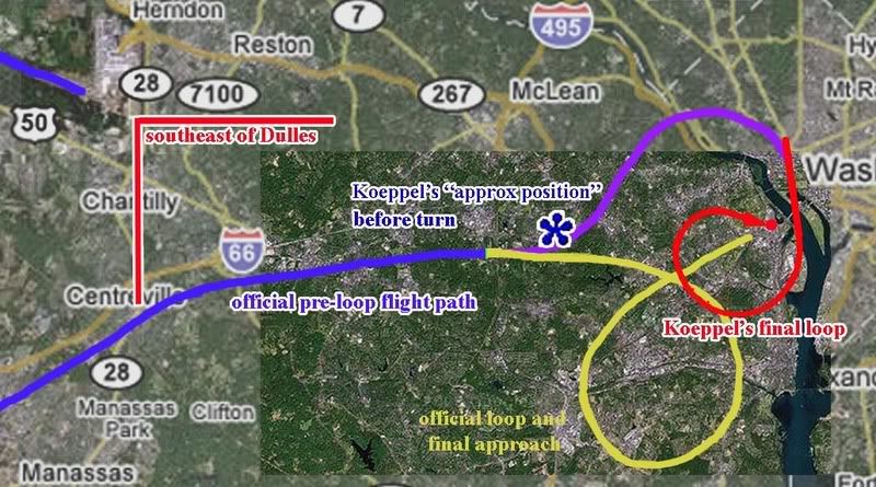 If the final loop Koeppel arrived at (red) was to be connected with the official story path (blue), that would necessitate the purple arc, or something similar, to connect the two. Since he was generally aware of the plane's position before turning (blue asterisk in the center of my map, actually pretty close to the official flight path, and nowhere near "the Potomac river north of town"), he in fact was implying the purple arc. However, he fails to explain or illustrate this turn to the left/north around and over DC, which is nowhere in his Reuter’s graphic or any other account. He made no mention of the full implied loop of roughly 400° from there needed for his loop to work.
In short, despite his ignorance of “ANY map of the Pentagon airplane's approach,” Koeppel was able to place the plane properly before its turn, but then invented the wild purple and red maneuver and only explained and illustrated the second half of it. He called this analysis and map “my contribution to the effort to try to make sense of an insane event. I don't know if it adds clarity or static, but it seems a part of the puzzle that has been missing.” [6] Looking at the method that gave us that half-map, it was clearly static he added. What’s surprising is that no one apparently caught on and this map became almost gospel. It was so widely used and believed to explain the oddity of the Pentagon attack (which is still odd enough) that it was interpreted by “Guardian” as possibly official; “the claimed flight path of flight 77 over Washington. […] In reality, flight 77 never existed.” [7]
The real loop, 330° to the south off an easterly approach, was new to some of the top 9/11 Pentagon researchers in mid-August 2006. At the Loose Change forum, Killtown showed the NTSB yellow-line loop map, seen in the just-released Flight Path Study. He labeled this as “new,” compared to Koeppel’s map, labeled “old.” Pickering, who had promoted the “old” map by featuring it on his site and working it into his other material, responded “the new flight path data does not change everything,” but it did help indicate to him that “I have a lot of re-writing to do these days!” Another member noted Pickering’s reliance on Koeppel’s map, and wondered of Koeppel “what he based his information on?” The question was not answered there, but I hope this analysis helps shed some light on the subject. [8]
---
More people who had fallen for it at some point (besides me, not that I even looked close until now): Jim Hoffman at one point used Koeppel's map to illustrate how a "Spiral Attack Maneuver Avoids Top Brass."
The bastards at Judicialinc captioned the map "NORAD's story that Hani Hanjour flew a 757 doing 600 MPH at 7000' and went into a 270 degree decending turn and hit the Pentagon, is absurd."
---
Sources:
[1] Segadevan, Nila.“The Impossibility of Flying Heavy Aircraft Without Training.” Looking Glass News. Feb 20, 2006
http://www.lookingglassnews.org/viewstory.php? storyid=5115
[2] Pickering, Russell. “Analysis of Flight 77 Flight Path” Pentagon Research.com. http://www.pentagonresearch.com/017.html
[3], [5], [6] [Koeppel, Steve. Analysis of Flight 77: Flight Path by a Former Air Force Pilot.” The Power Hour. Undated. http://www.thepowerhour.com/911_analysis/steves-analysis.htm
[4], [7] Guardian. “Flight 77 and the Pentagon. What Really Happened?” Undated. http://guardian.150m.com/pentagon/small/911-flights.htm
[8] Pickering, Russell, Terry Zarzoff, and Killtown. Comments posted August 12 2006. Loose Change Forum -> The Pentagon -> "New Flight 77 Path Different (of Course)." http://s15.invisionfree.com/Loose_Change_Forum/ar/t10366.htm
WHERE DID THAT COME FROM?
Adam Larson / Caustic Logic
The Frustrating Fraud
Posted July 25 2007
last updated 12/9/07
Note: This article deals with Steve Koeppel's loop map only. Arabesque has also posted an excellent post partly on this article, related with the three planes-confusion (FL77, a C-130, and an E-4B "doomsday plane," all verified in the area at the time), later expanded to cover other areas.
Note 12/9: Steve Koeppel himself (I presume) has popped in here to help explain some things (see comments below). "I did state that I had been an Air Force and Reserve navigator (I am NOT pilot in the military! Would somebody clear that up?!?)" Yes. Koeppel was not an Air Force Pilot as cited by The Power Hour. He was an Air Force navigator. "AT THAT TIME (early 2002) my intent was get suggestions on why there weren't any tourist photos (of Flight 77) [...] I made no claim to creating the unimpeachable analysis," he clarifies, "nor was that my intent; that's why I put so many qualifiers in my post." Good. Among the scant evidence he called on to create his path, one escaped my detectors and still does: "after disappearing from the radar scope the aircraft had had reappeared approaching D.C. from the north and was thought to have been aiming at the White House..." See below for full comment.
---
For years after 9/11, as controversy swirled over the details of the Pentagon attack, a working draft of the highly suspicious reported 3/4-circle loop in the flight path became widely used to cast doubt on the official story. This grand loop over Washington became one of the unifying points of agreement between Hunt The Boeing Pentagon no-planers and remote control-757 advocating “plane-huggers.” The general gist was eloquently summed up by Nila Sagadevan in early 2006:
“[T]his fanatic Muslim kamikaze pilot […] found that his “missile” was heading towards one of the most densely populated wings of the Pentagon—and one occupied by top military brass, including the Secretary of Defense, Rumsfeld. Presumably in order to save these men’s lives, he then executes a sweeping 270-degree turn and approaches the building from the opposite direction and aligns himself with the only wing of the Pentagon that was virtually uninhabited due to extensive renovations that were underway” [1]
While this sounds compelling, the flight path he’s talking about never existed. It was bolstered and seeded in the movement, above all, by this map:
Those who cite this precise angle of turn, point out the lack of White House defensive fire as the plane passed within a mile or two of it, or of the plane going out of its way to avoid Rumsfeld’s office, for which it was headed, are probably referring to this map, if to anything specific. Russell Pickering’s Pentagon Research.com used it to illustrate; “you can see where the White House was passed.” He also carefully cited the map’s originator, which makes it easy enough to look up and double-check. Author: Former Air Force Pilot Steve Koeppel, Palm Springs, CA [2]This led me to Koeppel’s undated piece, from way back, some time in 2002 it seems (it was mentioned by Hufschmid in Painful Questions, released 2002). The map and explanation of it were hosted originally by The Power Hour, producers of 911 In Plane Site, which is among the worst 9/11 videos ever, often dismissed as a too-long joke on the Truth Movement. Whatever the merits of his hosts, Koeppel's piece there explained how he reasoned out the map; none too promising is how he starts out with (apparent) inexplicable ignorance over the general contours of the flight:
“It was fairly simple to find the WTC routes, but I have yet to see a map showing the route flown by the aircraft that was said to have hit the Pentagon. So I read some of the reports and put together the attached maps. […] I'm surprised that I haven't seen this map — or ANY map — of the Pentagon airplane's approach. Given all the information that we were deluged with in the weeks after the attacks, it surprises me that this graphic was omitted.” [3]
The flight path of Flight 77 was not omitted by any measure, and it was not hard to find – even I knew the general outline of the flight, as : first published in Time, Newsweek, etc in the days after the attacks. Yes, the return path was a dotted line back then, estimated obviously, and too vague yet to show 77’s final loop, which was apparently his main question. But all these paths have proven broadly accurate in that the 757 headed west, turned south over the WV-KY-OH border area, lost transponder, and returned, heading east straight to the Pentagon. “Guardian” was one of the few that noted of Koeppel’s path “that this is a very strange flight path for an aircraft coming from the east and planning to crash into the Pentagon.” [4] It’s at least as odd for Flight 77, which was coming in from the southwest and finally impacted from the southwest, to wind up swooping down on the Pentagon from the northeast as in Koeppel’s map.
As an ill-fated aside before explaining his sources, Koeppel pointed out “what's surprising is how many news sources got the information wrong. For example, look at this graphic from Reuters, which has the attack on the wrong side of the Pentagon:”
Above is the graphic he used [right-click, new wiindow to enlarge], labeled “The Pentagon Attack” and featuring a six-point timeline of events, along with a grossly incorrect impact point shown. What’s at least as surprising, in my opinion, is where Koeppel explains “I based my map of the attack path on a description of the attack (see Pentagon Attack) which said the plane was initially picked up on radar east-southeast of Dulles heading at high speed toward Washington.” [5] Red flag! He introduces the erred Reuters graphic, and then tells us his whole analysis is based on a single account, and it’s this same graphic. Another wrong point in it he (understandably) failed to catch was its understatement of the loop by 60° – it was indeed to the right (south) but was actually 330°, nearly full circle, a descriptor widely used outside of the source he chose. As for how he came up with the southward swoop, Koeppel explained it as starting from “the 270 degree right turn” leaving him “puzzled.” A “near-circular” turn to the right, off an approach from the west, to hit the Pentagon at the final angle he gave no clue of being aware of, Koeppel might’ve guessed something like the official and logical connecting loop (here in yellow). Instead, he decided to bring it in from the north; “I realized that [the 3/4 loop] would provide a simple set of landmarks for the pilot. Just intercept the Potomac River north of town, follow it south until you see the Washington Monument or Capitol,” and then, as the Reuters guy said, make a 270 degree right turn and hit the far north edge of the west wall at the fourth-floor level. So thinking like a novice pilot, he found an arbitrary 270° line of landmarks in that area that might guide one to the target, and then presumed that to be the most logical flight path that he felt “meets all the conditions in the description.” Below is a map that helps clarify that his entire red arc is indeed east-southeast of Dulles, barely, and this seems to be a plausible path – if we disregard the official and logical flight path up till then (blue).
If the final loop Koeppel arrived at (red) was to be connected with the official story path (blue), that would necessitate the purple arc, or something similar, to connect the two. Since he was generally aware of the plane's position before turning (blue asterisk in the center of my map, actually pretty close to the official flight path, and nowhere near "the Potomac river north of town"), he in fact was implying the purple arc. However, he fails to explain or illustrate this turn to the left/north around and over DC, which is nowhere in his Reuter’s graphic or any other account. He made no mention of the full implied loop of roughly 400° from there needed for his loop to work. In short, despite his ignorance of “ANY map of the Pentagon airplane's approach,” Koeppel was able to place the plane properly before its turn, but then invented the wild purple and red maneuver and only explained and illustrated the second half of it. He called this analysis and map “my contribution to the effort to try to make sense of an insane event. I don't know if it adds clarity or static, but it seems a part of the puzzle that has been missing.” [6] Looking at the method that gave us that half-map, it was clearly static he added. What’s surprising is that no one apparently caught on and this map became almost gospel. It was so widely used and believed to explain the oddity of the Pentagon attack (which is still odd enough) that it was interpreted by “Guardian” as possibly official; “the claimed flight path of flight 77 over Washington. […] In reality, flight 77 never existed.” [7]
The real loop, 330° to the south off an easterly approach, was new to some of the top 9/11 Pentagon researchers in mid-August 2006. At the Loose Change forum, Killtown showed the NTSB yellow-line loop map, seen in the just-released Flight Path Study. He labeled this as “new,” compared to Koeppel’s map, labeled “old.” Pickering, who had promoted the “old” map by featuring it on his site and working it into his other material, responded “the new flight path data does not change everything,” but it did help indicate to him that “I have a lot of re-writing to do these days!” Another member noted Pickering’s reliance on Koeppel’s map, and wondered of Koeppel “what he based his information on?” The question was not answered there, but I hope this analysis helps shed some light on the subject. [8]
---
More people who had fallen for it at some point (besides me, not that I even looked close until now): Jim Hoffman at one point used Koeppel's map to illustrate how a "Spiral Attack Maneuver Avoids Top Brass."
The bastards at Judicialinc captioned the map "NORAD's story that Hani Hanjour flew a 757 doing 600 MPH at 7000' and went into a 270 degree decending turn and hit the Pentagon, is absurd."
---
Sources:
[1] Segadevan, Nila.“The Impossibility of Flying Heavy Aircraft Without Training.” Looking Glass News. Feb 20, 2006
http://www.lookingglassnews.org/viewstory.php? storyid=5115
[2] Pickering, Russell. “Analysis of Flight 77 Flight Path” Pentagon Research.com. http://www.pentagonresearch.com/017.html
[3], [5], [6] [Koeppel, Steve. Analysis of Flight 77: Flight Path by a Former Air Force Pilot.” The Power Hour. Undated. http://www.thepowerhour.com/911_analysis/steves-analysis.htm
[4], [7] Guardian. “Flight 77 and the Pentagon. What Really Happened?” Undated. http://guardian.150m.com/pentagon/small/911-flights.htm
[8] Pickering, Russell, Terry Zarzoff, and Killtown. Comments posted August 12 2006. Loose Change Forum -> The Pentagon -> "New Flight 77 Path Different (of Course)." http://s15.invisionfree.com/Loose_Change_Forum/ar/t10366.htm
Saturday, September 15, 2007
REBUTTAL TO JAMES FETZER
LITMUS TEST FOR RATIONAILTY?
REBUTTAL TO JAMES FETZER
Adam Larson / Caustic Logic
The Frustrating Fraud
June 27 2007
last updated September 15 2007
A new press release boosting Pilots for 9/11 Truth as “driv[ing] another nail into a coffin of lies told the American people by The 9/11 Commission” was just released by Scholars for 9/11 Truth (the Fetzer wing). Co-founder of the recently-divided organization James Fetzer in fact seems to have written up the release, titled “New study from Pilots for 9/11 Truth: No Boeing 757 hit the Pentagon.” It was released on June 21 and picked up by Yahoo news, apparently a bit of an achievement, and has been widely republished since then. It demands a firm, well thought out response from my end, and hence the slight delay in publishing this (and the later edits and updates).
As the public decree explains, the Pilots had petitioned the National Transportation Safety Board (NTSB) under the Freedom of Information Act to receive data from the Black Box (FDR) of Flight 77. Their study of the data, Fetzer announced, “has confirmed the previous findings of Scholars for 9/11 Truth that no Boeing 757 hit the Pentagon on 9/11.” [1] I'm not sure "report" is quite the right word; it's "signed by fifteen professional pilots," so it seems to be their three-month-old March 26 Press Release, which summarized all their AA77 FDR findings. Fetzer sums their points: “the plane was too high to hit lamp posts and would have flown over the Pentagon, not impacted with its ground floor.” So it's not terribly “new,” and what’s even older is the tired list of hollow no-planer reasoning that is his group’s bolstered previous argument.
"We have had four lines of proof that no Boeing 757 hit the building,” he explained, all flawed, well-explained or seriously questioned elsewhere, and too boring to bother re-hashing in detail here; but briefly, 1) the too small hole and “the wrong […] kind and quantity of debris,” 2) the CCTV video that shows something smaller than a 757 he thinks, 3) ground effect, and 4) the unmarked lawn. These four tracks of reasoning prove to Fetzer, “conclusively, in my judgment - that no Boeing 757 hit the building.” Noting the eyewitness accounts of an AA 757 that flew by that way as the “most important evidence to the contrary,” he found that “if the NTSB data is correct, then the Pilot's study shows that a large aircraft headed toward the building but did not impact with it. It swerved off and flew above the Pentagon." [2] Just like others have been theorizing lately. How nicely it all falls together… and the Pilots don’t even have to offer a theory themselves.
Anyway…he wrote the piece with the cooperation of Rob Balsamo (John Doe X, co-founder of Pilots for 911 Truth), who explained elsewhere “Jim Fetzer and myself worked on this together.” Yet the final PR contained a major blunder… Fetzer stated that the Pilots “not only obtained the flight data but created a computer animation to demonstrate what it told them.” [3] What on Earth does that mean? I haven't seen this other animation yet, and had just been in a wrangle with Balsamo for hinting at just that possibility, contrary to their claims. Balsamo had to scramble to clarify their group “did not create the animation, which we included in "Pandora's Back Box". The NTSB provided the animation based upon its own data and spread spread sheets which can be found at our site/forums.” [4]
--
update 8/11: Recently Pilots for Truth did release an animation based on the black box data. It's pretty interesting and well done. Viewable here. Perhaps this is what Fetzer was talking about?
update 9/15: As Rob has pointed out to me, the crossed-out statement above is wrong - based on a misreading. Aplogies to have miseld with this sloppiness. They worked together on the corrections, as is obvious when I look back. In pennance, a gratis link to his unfiltered words.
--
Otherwise Fetzer carefully quotes Balasamo’s vague copy-and-paste master take on their findings: "the information in the NSTB documents does not support, and in some instances factually contradicts, the official government position that American Airlines Flight 77 struck the Pentagon on the morning of September 11, 2001." While it’s more tame than what Fetzer says, he’s not so much putting words in Balsamo’s mouth as – well, here’s another careful quote:
“Pilotsfor911truth.org does not make the claim that "No Boeing 757 hit the Pentagon". We have analyzed the Flight Data Recorder data provided by the NTSB and have shown factual analysis of that data. We do not offer theory.
While we do not make this claim in these words, the analysis we present on the basis of the NTSB's own data factually contradicts the official account that Flight 77 hit the Pentagon--if trends are continued beyond end of data records--and therefore supports the inference that American Airlines Flight 77 did not hit the building based upon that data.” [5]
In other words, they have only discovered and relayed factual government data that supports the inference that the plane would not have hit. They didn’t say it didn’t hit. They let Fetzer say it for them.
“Don't be taken in by photos showing damage to the second floor or those taken after the upper floors collapsed, which happened 20-30 minutes later," Fetzer warned, and by which I’m not sure what he means. "In fact, debris begins to show up on the completely clean lawn in short order,” and proposed this fake plane debris “might have been dropped from a C-130 that was circling above the Pentagon or placed there by men in suits who were photographed carrying debris with them." [6] Might be…
The most famous such scrap, photographed by Mark Faram, Fetzer admits “is a piece from the fuselage of a commercial airliner, which is frequently adduced as evidence,” by, for example, James Hanson of Ohio. Fetzer explains in his PR that Hanson “has traced that debris to an American Airlines 757 that crashed in a rain forest above Cali, Columbia in 1995.” Check out what this genius Hanson uses for evidence: a six-year old liana vine still embedded in the Pentagon "fuselage" metal! You have to see it to disbelieve it, so DO NOT click that link if you want to believe Hanson. Fetzer bought it though and was impressed enough with this find to offer to republish Hanson’s study on the Scholars’ site. [7]
One of the deepest ironies revealed in Fetzer’s missive is that "Fetzer [...] retired last June after 35 years of teaching courses in logic, critical thinking, and scientific reasoning.” Well, how could one argue with the logical conclusions of a renowned logic expert? I’ll try it caustically. Fact is, what this background of his shows to me is that he knows exactly what he’s doing – elevating a fraud to guiding principle of the “Truth Movement” he claims a leadership role in to arrive at the “truth.” In the end, from all this Fetzer was able to use his deep knowledge of ctical thinking and scientific deduction (as well, of course, as years learning all of their opposites – the arts of sophistry, quackery, and deception) to deduce an argument finally totally inverse to my own growing suspicions:
"The Pentagon has become a kind of litmus test for rationality in the study of 9/11. Those who persist in maintaining that a Boeing 757 hit the building are either unfamiliar with the evidence or cognitively impaired. Unless they want to mislead the American people. The evidence is beyond clear and compelling. It places this issue 'beyond a reasonable doubt'. No Boeing 757 hit the Pentagon."
I am quite familiar with the evidence, and I invite anyone to check my reasoning for soundness of judgment. That’s what this site’s about: “the hijacking of the 9/11 Truth Movement by the no-757 at the Pentagon theory." It almost feels with this salvo like Fetzer the mental “muscle hijacker” is letting us know the pilots have the cockpit; he tells us never mind the doubters, move to the back of the plane. No need to investigate for yourselves, we have it all figured out. We are returning to the airport. We just need to agree on this and move on.
But what if the Pilots intend to crash this plane? It’s happened before. That's not even a box cutter Fetzer's holding, people. It's a carbdoard prop. We can take this plane back. Let's Roll.
Sources:
[1], [2], [3], [6], [7] Fetzer, James/Scholars for 9/11 Truth. “New study from Pilots for 9/11 Truth: No Boeing 757 hit the Pentagon.” June 21 2007.
Trackback URL: http://prweb.com/pingpr.php/Q291cC1NYWduLVRoaXItQ291cC1UaGlyLVplcm8=
http://news.yahoo.com/s/prweb/20070621/bs_prweb/prweb534642_1
[4], [5] John Doe X. Official Comment/corrections. Pilots for 9/11 Truth Discussion Board. Posted Jun 23 2007, 12:36 AM. http://z9.invisionfree.com/Pilots_For_Truth/index.php?s=ec3b737719855ae19fc27c1b5a81c7b0&showtopic=7372&st=15&#entry9361808
REBUTTAL TO JAMES FETZER
Adam Larson / Caustic Logic
The Frustrating Fraud
June 27 2007
last updated September 15 2007
A new press release boosting Pilots for 9/11 Truth as “driv[ing] another nail into a coffin of lies told the American people by The 9/11 Commission” was just released by Scholars for 9/11 Truth (the Fetzer wing). Co-founder of the recently-divided organization James Fetzer in fact seems to have written up the release, titled “New study from Pilots for 9/11 Truth: No Boeing 757 hit the Pentagon.” It was released on June 21 and picked up by Yahoo news, apparently a bit of an achievement, and has been widely republished since then. It demands a firm, well thought out response from my end, and hence the slight delay in publishing this (and the later edits and updates).
As the public decree explains, the Pilots had petitioned the National Transportation Safety Board (NTSB) under the Freedom of Information Act to receive data from the Black Box (FDR) of Flight 77. Their study of the data, Fetzer announced, “has confirmed the previous findings of Scholars for 9/11 Truth that no Boeing 757 hit the Pentagon on 9/11.” [1] I'm not sure "report" is quite the right word; it's "signed by fifteen professional pilots," so it seems to be their three-month-old March 26 Press Release, which summarized all their AA77 FDR findings. Fetzer sums their points: “the plane was too high to hit lamp posts and would have flown over the Pentagon, not impacted with its ground floor.” So it's not terribly “new,” and what’s even older is the tired list of hollow no-planer reasoning that is his group’s bolstered previous argument.
"We have had four lines of proof that no Boeing 757 hit the building,” he explained, all flawed, well-explained or seriously questioned elsewhere, and too boring to bother re-hashing in detail here; but briefly, 1) the too small hole and “the wrong […] kind and quantity of debris,” 2) the CCTV video that shows something smaller than a 757 he thinks, 3) ground effect, and 4) the unmarked lawn. These four tracks of reasoning prove to Fetzer, “conclusively, in my judgment - that no Boeing 757 hit the building.” Noting the eyewitness accounts of an AA 757 that flew by that way as the “most important evidence to the contrary,” he found that “if the NTSB data is correct, then the Pilot's study shows that a large aircraft headed toward the building but did not impact with it. It swerved off and flew above the Pentagon." [2] Just like others have been theorizing lately. How nicely it all falls together… and the Pilots don’t even have to offer a theory themselves.
Anyway…
--
update 8/11: Recently Pilots for Truth did release an animation based on the black box data. It's pretty interesting and well done. Viewable here. Perhaps this is what Fetzer was talking about?
update 9/15: As Rob has pointed out to me, the crossed-out statement above is wrong - based on a misreading. Aplogies to have miseld with this sloppiness. They worked together on the corrections, as is obvious when I look back. In pennance, a gratis link to his unfiltered words.
--
Otherwise Fetzer carefully quotes Balasamo’s vague copy-and-paste master take on their findings: "the information in the NSTB documents does not support, and in some instances factually contradicts, the official government position that American Airlines Flight 77 struck the Pentagon on the morning of September 11, 2001." While it’s more tame than what Fetzer says, he’s not so much putting words in Balsamo’s mouth as – well, here’s another careful quote:
“Pilotsfor911truth.org does not make the claim that "No Boeing 757 hit the Pentagon". We have analyzed the Flight Data Recorder data provided by the NTSB and have shown factual analysis of that data. We do not offer theory.
While we do not make this claim in these words, the analysis we present on the basis of the NTSB's own data factually contradicts the official account that Flight 77 hit the Pentagon--if trends are continued beyond end of data records--and therefore supports the inference that American Airlines Flight 77 did not hit the building based upon that data.” [5]
In other words, they have only discovered and relayed factual government data that supports the inference that the plane would not have hit. They didn’t say it didn’t hit. They let Fetzer say it for them.
“Don't be taken in by photos showing damage to the second floor or those taken after the upper floors collapsed, which happened 20-30 minutes later," Fetzer warned, and by which I’m not sure what he means. "In fact, debris begins to show up on the completely clean lawn in short order,” and proposed this fake plane debris “might have been dropped from a C-130 that was circling above the Pentagon or placed there by men in suits who were photographed carrying debris with them." [6] Might be…
The most famous such scrap, photographed by Mark Faram, Fetzer admits “is a piece from the fuselage of a commercial airliner, which is frequently adduced as evidence,” by, for example, James Hanson of Ohio. Fetzer explains in his PR that Hanson “has traced that debris to an American Airlines 757 that crashed in a rain forest above Cali, Columbia in 1995.” Check out what this genius Hanson uses for evidence: a six-year old liana vine still embedded in the Pentagon "fuselage" metal! You have to see it to disbelieve it, so DO NOT click that link if you want to believe Hanson. Fetzer bought it though and was impressed enough with this find to offer to republish Hanson’s study on the Scholars’ site. [7]
 |
"The Pentagon has become a kind of litmus test for rationality in the study of 9/11. Those who persist in maintaining that a Boeing 757 hit the building are either unfamiliar with the evidence or cognitively impaired. Unless they want to mislead the American people. The evidence is beyond clear and compelling. It places this issue 'beyond a reasonable doubt'. No Boeing 757 hit the Pentagon."
I am quite familiar with the evidence, and I invite anyone to check my reasoning for soundness of judgment. That’s what this site’s about: “the hijacking of the 9/11 Truth Movement by the no-757 at the Pentagon theory." It almost feels with this salvo like Fetzer the mental “muscle hijacker” is letting us know the pilots have the cockpit; he tells us never mind the doubters, move to the back of the plane. No need to investigate for yourselves, we have it all figured out. We are returning to the airport. We just need to agree on this and move on.
But what if the Pilots intend to crash this plane? It’s happened before. That's not even a box cutter Fetzer's holding, people. It's a carbdoard prop. We can take this plane back. Let's Roll.
Sources:
[1], [2], [3], [6], [7] Fetzer, James/Scholars for 9/11 Truth. “New study from Pilots for 9/11 Truth: No Boeing 757 hit the Pentagon.” June 21 2007.
Trackback URL: http://prweb.com/pingpr.php/Q291cC1NYWduLVRoaXItQ291cC1UaGlyLVplcm8=
http://news.yahoo.com/s/prweb/20070621/bs_prweb/prweb534642_1
[4], [5] John Doe X. Official Comment/corrections. Pilots for 9/11 Truth Discussion Board. Posted Jun 23 2007, 12:36 AM. http://z9.invisionfree.com/Pilots_For_Truth/index.php?s=ec3b737719855ae19fc27c1b5a81c7b0&showtopic=7372&st=15&#entry9361808
Friday, July 20, 2007
FINAL ALTITUDE: EIGHT READINGS
FINAL ALTITUDE: EIGHT READINGS
Adam Larson / Caustic Logic
The Frustrating Fraud
July 19 2007
updated 8/12
Note1: I’m not precisely certain on ground level altitude at the Pentagon, but it seems to be in the range of about 35-40 feet above mean Sea level (ft msl), so to keep the math simple I’ve rounded it to 40. The discrepancy should be no more than five feet from reality.
Note 2: Possible explanation for pressure altitude errors: airspeed at least has been known to effect this reading, and from what I hear, errors in the range of 100 feet or more are not uncommon. This consideration is relevant for the different pressure altimeter readings in possibilities 2, 3, 5, 6, and 7.
1) Official story/physical evidence/eyewitness reports of impact: these multi-corroborated sources indicate the Pentagon attack plane’s belly was about 5 feet above ground, or about 45 ft msl. A majority of the fuselage impacted just beneath the second floor slab, with left engine and perhaps wingtip in fact hitting objects at ground level. (Source: reality or mind-boggling fakery)
2) Specialist’s Factual Report of Investigation (SFRI): Final alt is unsure – seems near zero but the graph resolution is not high enough to read precisely. In general contours it matches perfectly the more detailed Flight Path Study. (Source: straight from NTSB)
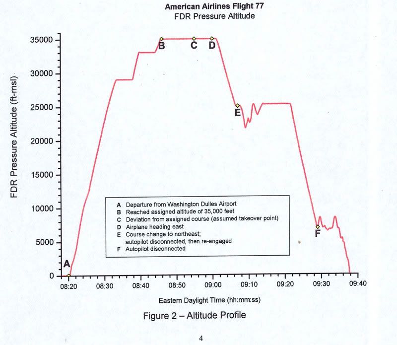 3) Flight Path Study graphing: Still not precisely clear - FDR pressure altitude measured in ft-msl. Lowest graph division is 1,000 feet – Pentagon impact seems to be about zero feet MSL, close to its actual elevation of 40 ft msl. However the Dulles takeoff at about 300 msl, 260 feet higher than the Pentagon, also charts out at what seems zero ft msl, or 300 feet underground? (Source: straight from NTSB - click to enlarge graphic)
4) The PentaCon reading of their eyewitnesses: 100% of their witnesses colse enough to see were convinced of an impact, but various clues indicate a flyover, At least 74 feet above ground level (agl), or 114 ft msl, or the lowest possible level above the roof. The range above that is theoretically limitless, but the lower the altitude, the more likely it could be mistaken by witnesses as an impact with the 73-foot-high building. The higher the altitude, the less sense the flyover theory makes. (Source: Citizen’s Investigative Team)
5) AAl_77.tab, tabular CSV file: final frame altitude of 173 msl, again pressure altitude - sixty feet over the buildin'g roofline. Takeoff alt was at correct elevation for Dulles airport of 300. The CSV file also shows a manual reset of the pressure altimeter at 18,000 feet on descent into the attack, as per FAA regulations, with no apparent effect on recorded pressure alt settings. (Source: NTSB via P49T member Undertow - I need to post my analysis on this soon)
6) The animation, uncorrected, has it 140 feet above ground at the end, somewhat lower at “impact point” if the trends were to continue, but certainly too high to have clipped the poles, hit the generator, or impacted the building. The closeness of this to the CSV indicates the animation was based on pressure altitude – especially with no operative radio altimeter. (source: NTSB via Snowygrouch, then SLOB, Mitch Harrison, etc. – link coming)
7) Read Out 2: An anonymous and irreproducable decoding of the unreadable L3 raw file reveals the nonexistent radio altimeter shows a 270 foot altitude above ground level (agl) at the end. This reading is based on signals bounced from the ground and not subject to pressure alt errors. Radio altimeter is listed in SFRI as inoperative and left blank. Snowygrouch says the reading “had been omitted by the NTSB […] for reasons known only to themselves,” even though it was “precisely the same as the pressure altitude.” It isn’t. (See readings 2, 3, 5, 6) (Source: it’s complicated – the story is here.)
8) John Doe X corrected: When the animation’s final altitude is adjusted to reflect the pressure reset not shown in the animation, the plane is 480 ft msl, 440 ft agl, and 367 ft above the Pentagon’s roof. This is probably too high to have been seen by witnesses at all, and far too high to have been mistaken for an impact. (Source: Animation plus JDX calculations)
Clearly not all of these six altitudes can be correct, though it’s not right to say only one is. Some may corroborate each other, like the animation and CSV, or official and CSV if the alt error was high enough. But to corroborate the PentaCon witness reading, it’d have to be just above the Pentagon roof, and well below that to support the official impact story; there was no high-impact “near-flyover.” It hit low or it didn’t hit.
But this is the only altitude of the eight that also allows the plane to strike the building - matching the (faked?) CCTV video footage, the (fooled?) closest eyewitnesses, the PentaCon’s own (duped?) witnesses, the (planted?) clipped poles and (engineered?) lawn-area damage, the (faked?) 300-foot deep damage to the Pentagon, the (planted?) 757 parts, etc. All these, taken collectively as reality (a leap some are unwilling to take), rule out any altitude higher than the official one. Readings 2, 3, 5, and 6 all could possibly correspond with this, due to the common errors of pressure altimeters, but certainly NTSB data seeming to place the plane well above the roof is problematic.
The higher readings each rule out all of this evidence and each other, and are supported precisely by themselves; another reading with no other backing. There may be more readings yet to come – say, 375 ft msl, or 30,000. That’d be new.

Adam Larson / Caustic Logic
The Frustrating Fraud
July 19 2007
updated 8/12
Note1: I’m not precisely certain on ground level altitude at the Pentagon, but it seems to be in the range of about 35-40 feet above mean Sea level (ft msl), so to keep the math simple I’ve rounded it to 40. The discrepancy should be no more than five feet from reality.
Note 2: Possible explanation for pressure altitude errors: airspeed at least has been known to effect this reading, and from what I hear, errors in the range of 100 feet or more are not uncommon. This consideration is relevant for the different pressure altimeter readings in possibilities 2, 3, 5, 6, and 7.
1) Official story/physical evidence/eyewitness reports of impact: these multi-corroborated sources indicate the Pentagon attack plane’s belly was about 5 feet above ground, or about 45 ft msl. A majority of the fuselage impacted just beneath the second floor slab, with left engine and perhaps wingtip in fact hitting objects at ground level. (Source: reality or mind-boggling fakery)
2) Specialist’s Factual Report of Investigation (SFRI): Final alt is unsure – seems near zero but the graph resolution is not high enough to read precisely. In general contours it matches perfectly the more detailed Flight Path Study. (Source: straight from NTSB)
3) Flight Path Study graphing: Still not precisely clear - FDR pressure altitude measured in ft-msl. Lowest graph division is 1,000 feet – Pentagon impact seems to be about zero feet MSL, close to its actual elevation of 40 ft msl. However the Dulles takeoff at about 300 msl, 260 feet higher than the Pentagon, also charts out at what seems zero ft msl, or 300 feet underground? (Source: straight from NTSB - click to enlarge graphic)4) The PentaCon reading of their eyewitnesses: 100% of their witnesses colse enough to see were convinced of an impact, but various clues indicate a flyover, At least 74 feet above ground level (agl), or 114 ft msl, or the lowest possible level above the roof. The range above that is theoretically limitless, but the lower the altitude, the more likely it could be mistaken by witnesses as an impact with the 73-foot-high building. The higher the altitude, the less sense the flyover theory makes. (Source: Citizen’s Investigative Team)
5) AAl_77.tab, tabular CSV file: final frame altitude of 173 msl, again pressure altitude - sixty feet over the buildin'g roofline. Takeoff alt was at correct elevation for Dulles airport of 300. The CSV file also shows a manual reset of the pressure altimeter at 18,000 feet on descent into the attack, as per FAA regulations, with no apparent effect on recorded pressure alt settings. (Source: NTSB via P49T member Undertow - I need to post my analysis on this soon)
6) The animation, uncorrected, has it 140 feet above ground at the end, somewhat lower at “impact point” if the trends were to continue, but certainly too high to have clipped the poles, hit the generator, or impacted the building. The closeness of this to the CSV indicates the animation was based on pressure altitude – especially with no operative radio altimeter. (source: NTSB via Snowygrouch, then SLOB, Mitch Harrison, etc. – link coming)
7) Read Out 2: An anonymous and irreproducable decoding of the unreadable L3 raw file reveals the nonexistent radio altimeter shows a 270 foot altitude above ground level (agl) at the end. This reading is based on signals bounced from the ground and not subject to pressure alt errors. Radio altimeter is listed in SFRI as inoperative and left blank. Snowygrouch says the reading “had been omitted by the NTSB […] for reasons known only to themselves,” even though it was “precisely the same as the pressure altitude.” It isn’t. (See readings 2, 3, 5, 6) (Source: it’s complicated – the story is here.)
8) John Doe X corrected: When the animation’s final altitude is adjusted to reflect the pressure reset not shown in the animation, the plane is 480 ft msl, 440 ft agl, and 367 ft above the Pentagon’s roof. This is probably too high to have been seen by witnesses at all, and far too high to have been mistaken for an impact. (Source: Animation plus JDX calculations)
Clearly not all of these six altitudes can be correct, though it’s not right to say only one is. Some may corroborate each other, like the animation and CSV, or official and CSV if the alt error was high enough. But to corroborate the PentaCon witness reading, it’d have to be just above the Pentagon roof, and well below that to support the official impact story; there was no high-impact “near-flyover.” It hit low or it didn’t hit.
But this is the only altitude of the eight that also allows the plane to strike the building - matching the (faked?) CCTV video footage, the (fooled?) closest eyewitnesses, the PentaCon’s own (duped?) witnesses, the (planted?) clipped poles and (engineered?) lawn-area damage, the (faked?) 300-foot deep damage to the Pentagon, the (planted?) 757 parts, etc. All these, taken collectively as reality (a leap some are unwilling to take), rule out any altitude higher than the official one. Readings 2, 3, 5, and 6 all could possibly correspond with this, due to the common errors of pressure altimeters, but certainly NTSB data seeming to place the plane well above the roof is problematic.
The higher readings each rule out all of this evidence and each other, and are supported precisely by themselves; another reading with no other backing. There may be more readings yet to come – say, 375 ft msl, or 30,000. That’d be new.
Monday, July 16, 2007
A SLOW ZOOM ON THE FINAL LOOP
A SLOW ZOOM ON THE FINAL LOOP
Adam Larson / Caustic Logic
The Frustrating Fraud
July 16 2007
last updated July 19
Connecting the Dots
 The initial flight path of hijacked Flight 77, as published in the days after the attacks, was largely a connect-the-dots approach. With no transponder after the terrorist takeover, and, we were told, “limited primary radar coverage” along the attack route, the return flight was not seen for a half-hour until it entered Washington airspace with its own radar. [1] The dotted line estimations published at this point sowed among the first seeds of suspicion over the attack. Was there a swap out there in the blind spot? As more evidence comes to light, all these paths have proven broadly accurate in that the 757 headed west, turned south over the WV-KY-OH border area, lost transponder, and returned, heading East straight to the Pentagon. Of the three maps above, Newsweek’s is the most accurate. USA Today’s path has a pronounced hump giving it a submarine profile, and Time’s map has the plane swooping north on its way back, crossing its outbound flight path, twisting the loop into an infinity symbol.
The final line of the journey as it passed east of its origin at Dulles, seems from here uneventful. But in these same early days reports surfaced of a tight, controlled, implausible loop over eastern Virginia, thought by many beyond the reported skills of the alleged hijacker Hani Hanjour. Facing the west wall, Flight 77 was said to have turned 270°-360° to hit - the west wall – oddly enough, the side just renovated to withstand bombs and impacts, largely empty, and across the building from the Defense Secretary’s Office. [more on the radar blind spot and the impact location in "From the blind spot to the empty side."]
Few if any eyewitness accounts seem to address the grand loop, since it was simply too big to have been seen by any one person – the first part of it was perhaps too high to attract much attention, but as it approached the Navy Annex and continued to lose altitude, it attracted more witnesses in its last several seconds, by which time it was going straight towards the Pentagon’s west wall. With such published accounts as the early cornerstone of our awareness of the attack, this magical loop remained largely invisible, possibly another government lie.
The overall uncertainty over 77’s approach lead many to accept this flight path as plausible to explain the final loop. It has Flight 77 flying south through DC’s restricted airspace with no White House defensive fire, headed towards Rumsfeld’s office before turning to hit the opposite side of the Pentagon, giving us the 270° turn so often cited. This map is quite wrong, understating the actual degree of turn by 60° and grossly misreading the original heading. [How this old map was arrived at and what’s wrong with it is explained separately in "the "old" 270° loop explained."]
The Radar Record
Among the too-vague early report was this from the ever-unbelievable Vice President Cheney, five days after the attack: "it entered the danger zone and looked like it was headed for the White House [...] Didn't circle it, but was headed on a track into it. [...] It turned away and, we think, flew a circle and came back in and then hit the Pentagon. And that's what the radar track looks like." [2] Five days later CBS News reported “radar shows Flight 77 did a downward spiral, turning almost a complete circle,” after which “the jetliner disappeared from radar at 9:37 and less than a minute later it clipped the tops of street lights and plowed into the Pentagon at 460 mph.” [3]
It was another month before radar specialist Danielle O’Brien, on duty at the Dulles ATC tower on 9/11, told ABC News’ 20/20 “it was an unidentified plane to the southwest of Dulles, moving at a very high rate of speed [...] I had literally a blip and nothing more.” As it headed towards the Pentagon, “it was just a countdown. Ten miles west. Nine miles west […] And it went six, five, four. And I had it in my mouth to say, three, and all of a sudden the plane turned away. In the room, it was almost a sense of relief.” But the turn continued until it was much lower and facing the same direction, after which O’Brien tersely summed up "we lost radar contact with that aircraft [...] and then the Washington National controllers came over our speakers [saying] The Pentagon's been hit.” [4]
O’Brien’s interview, aired in late October 2001, was accompanied by a radar screen graphic with a south loop of near 360 degrees off the east-bound flight as seen on radar screens. Seen briefly by millions, perhaps many thought this arc of dots just a guess or irrelevant, but in fact this same path would prove accurate and come back to bite them in the butt five years later. [Other than the red lettering, this picture is a direct screenshot from the program, viewable here.]

Official Reports: Zooming the Lump
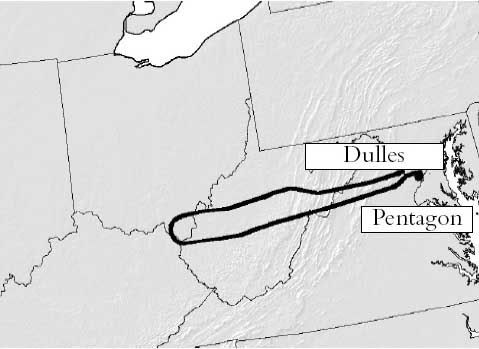 We were only allowed a slow zoom in on what that loop actually looked like in the chain of official reports. Initial NTSB studies were kept behind closed doors, being in the FBI’s jusrisdiction and exempt from FOIA requirements. But the correct loop is there in a map from the 9/11 Commission’s Final Report, released mid-2004. Note its general agreement with early reports, and also the little lump of ink on the south side of the terminal tip – that’s the final loop, unreadable in this bold line on an unnecessarily zoomed back map. This line is apparently taken from the NTSB’s Flight Path Study, made from FDR and radar data in February 2002, classified at the time but available to the commission and cited in the endnotes. The report explained how at "5 miles west-southwest of the Pentagon," Flight 77 "began a 330 degree turn." [5]
That document was finally released via numerous FOIA requests in August 2006 and posted online from numerous angles. Finally we see a zoom in on the mysterious grand loop [see below]. First we see their overall flight path, printed big enough to show a silly little loop at the end [blue box], and also a detail of the loop all on its own page, faded yellow on a pale orange topo map [red box]. This is labeled in the report as “DC area flight path,” so possibly from ATC radar track, while the overall flight path above it is said to be from the matching FDR/radar data. [6]

The Black Box
Additional Flight Data Recorder information further verifies this loop. The Specilaist’s Factual Report of Investigation (SFRI), is an NTSB documented drawing exclusively on the full Black Box readings, also released in the 2006 rush. It has all functioning parameters graphed out for the duration of the flight, spread out over 17 pages; The basics -altitude, airspeed, and magnetic heading - are reproduced on each page. Here is the clearest extraction I've taken of this, edited to show a zoomed-in final minutes reading. All lines and values are accurate according to the bars at right and left. [7]
 The story it tells is that at 9:34 Flight 77 began a remarkable thhree-minute turn just short of the Pentagon. The change in magnetic heading is graphed - as it approached DC with a general heading of about 95-100° magnetic –after a slight adjustment to the north and back at 9:31-32, the plane begins its loop at 9:34 – for about three minutes it turns south and then near-full circle to the west, north, and finally settling, at about 9:37, on a northeast heading of 70° magnetic, after completing the 330° turn and descending about 4,000 feet in the process, the last 45 seconds were a straight shot at that heading and a steady descent to roughly zero altitude at 9:37:45.
Here is how to read the headings on a map - apologies for the fruit-flavored style if that offends anyone’s sensibilities. The angle and color tells headingat a given mement, tehe direction the nose is pointing. Magnetic heading, which the FDR works with, are just about 10° higher compared to headings based on geographic north, since the magnetic north pole at that time was about ten degrees west of the true north. Read zero also as 360, due north, green. Here the plane starts out deep blue – due east, roughly 90° from north, 100 mag on the FDR - and its final heading is about 60°. Add ten to get magnetic, and this is what the FDR says – 70°.

The erred NTSB working copy animation, used by Pilots for 9/11 Truth, matches as well the official loop; their “final maneuver” video starts out at 9:34:03, turn just starting, and straightening out from 9:36:45-9:37:15 The onscreen mag heading dial roughly matches the other FDR data, settling on 70 after the loop – but of course the on-screen animation somehow ends up twenty degrees off from that, which is what places it “too far to the left” to have impacted the Pentagon, as the Pilots discovered…
Sources and editing: Coming
[1] Phillips, Don. “Pentagon Crash Highlights a Radar Gap.” Washington Post. November 3, 2001. Page A06. http://www.washingtonpost.com/ac2/wp-dyn?pagename=article&contentId=A32597-2001Nov2¬Found=true
[2] "The Vice President appears on Meet the Press with Tim Russert." Camp David, Maryland. September 16 2001. http://www.whitehouse.gov/vicepresident/news-speeches/speeches/vp20010916.html
[3] "Primary Target - THE PENTAGON." CBS News. September 21 2001. http://www.cbsnews.com/stories/2001/09/11/national/main310721.shtml
[4] "`Get These Planes on the Ground' - Air Traffic Controllers Recall Sept. 11," ABC News, October 24 2001. http://web.archive.org/web/20011024150915/http://abcnews.go.com/sections/2020/2020/2020_011024_atc_feature.html
[5] National Commission on Terrorist Attacks Upon the United States. The 9/11 Commission Report. map: p. 33. Citation of Flight Path Study: Page 459, source 59 for chapter 1. Explanation of the loop on page 9.
[6] FPS
[7] Specialist’s Factual Report of Investigation: Digital Flight Data Recorder . NTSB document number: DCA01MA064 National Transportation Safety Board, Vehicle Records Division. January 31 2002. PDF download link: http://www.ntsb.gov/info/AAL77_fdr.pdf
Adam Larson / Caustic Logic
The Frustrating Fraud
July 16 2007
last updated July 19
Connecting the Dots
The initial flight path of hijacked Flight 77, as published in the days after the attacks, was largely a connect-the-dots approach. With no transponder after the terrorist takeover, and, we were told, “limited primary radar coverage” along the attack route, the return flight was not seen for a half-hour until it entered Washington airspace with its own radar. [1] The dotted line estimations published at this point sowed among the first seeds of suspicion over the attack. Was there a swap out there in the blind spot? As more evidence comes to light, all these paths have proven broadly accurate in that the 757 headed west, turned south over the WV-KY-OH border area, lost transponder, and returned, heading East straight to the Pentagon. Of the three maps above, Newsweek’s is the most accurate. USA Today’s path has a pronounced hump giving it a submarine profile, and Time’s map has the plane swooping north on its way back, crossing its outbound flight path, twisting the loop into an infinity symbol. The final line of the journey as it passed east of its origin at Dulles, seems from here uneventful. But in these same early days reports surfaced of a tight, controlled, implausible loop over eastern Virginia, thought by many beyond the reported skills of the alleged hijacker Hani Hanjour. Facing the west wall, Flight 77 was said to have turned 270°-360° to hit - the west wall – oddly enough, the side just renovated to withstand bombs and impacts, largely empty, and across the building from the Defense Secretary’s Office. [more on the radar blind spot and the impact location in "From the blind spot to the empty side."]
Few if any eyewitness accounts seem to address the grand loop, since it was simply too big to have been seen by any one person – the first part of it was perhaps too high to attract much attention, but as it approached the Navy Annex and continued to lose altitude, it attracted more witnesses in its last several seconds, by which time it was going straight towards the Pentagon’s west wall. With such published accounts as the early cornerstone of our awareness of the attack, this magical loop remained largely invisible, possibly another government lie.
The overall uncertainty over 77’s approach lead many to accept this flight path as plausible to explain the final loop. It has Flight 77 flying south through DC’s restricted airspace with no White House defensive fire, headed towards Rumsfeld’s office before turning to hit the opposite side of the Pentagon, giving us the 270° turn so often cited. This map is quite wrong, understating the actual degree of turn by 60° and grossly misreading the original heading. [How this old map was arrived at and what’s wrong with it is explained separately in "the "old" 270° loop explained."]The Radar Record
Among the too-vague early report was this from the ever-unbelievable Vice President Cheney, five days after the attack: "it entered the danger zone and looked like it was headed for the White House [...] Didn't circle it, but was headed on a track into it. [...] It turned away and, we think, flew a circle and came back in and then hit the Pentagon. And that's what the radar track looks like." [2] Five days later CBS News reported “radar shows Flight 77 did a downward spiral, turning almost a complete circle,” after which “the jetliner disappeared from radar at 9:37 and less than a minute later it clipped the tops of street lights and plowed into the Pentagon at 460 mph.” [3]
It was another month before radar specialist Danielle O’Brien, on duty at the Dulles ATC tower on 9/11, told ABC News’ 20/20 “it was an unidentified plane to the southwest of Dulles, moving at a very high rate of speed [...] I had literally a blip and nothing more.” As it headed towards the Pentagon, “it was just a countdown. Ten miles west. Nine miles west […] And it went six, five, four. And I had it in my mouth to say, three, and all of a sudden the plane turned away. In the room, it was almost a sense of relief.” But the turn continued until it was much lower and facing the same direction, after which O’Brien tersely summed up "we lost radar contact with that aircraft [...] and then the Washington National controllers came over our speakers [saying] The Pentagon's been hit.” [4]
O’Brien’s interview, aired in late October 2001, was accompanied by a radar screen graphic with a south loop of near 360 degrees off the east-bound flight as seen on radar screens. Seen briefly by millions, perhaps many thought this arc of dots just a guess or irrelevant, but in fact this same path would prove accurate and come back to bite them in the butt five years later. [Other than the red lettering, this picture is a direct screenshot from the program, viewable here.]
Official Reports: Zooming the Lump
We were only allowed a slow zoom in on what that loop actually looked like in the chain of official reports. Initial NTSB studies were kept behind closed doors, being in the FBI’s jusrisdiction and exempt from FOIA requirements. But the correct loop is there in a map from the 9/11 Commission’s Final Report, released mid-2004. Note its general agreement with early reports, and also the little lump of ink on the south side of the terminal tip – that’s the final loop, unreadable in this bold line on an unnecessarily zoomed back map. This line is apparently taken from the NTSB’s Flight Path Study, made from FDR and radar data in February 2002, classified at the time but available to the commission and cited in the endnotes. The report explained how at "5 miles west-southwest of the Pentagon," Flight 77 "began a 330 degree turn." [5] That document was finally released via numerous FOIA requests in August 2006 and posted online from numerous angles. Finally we see a zoom in on the mysterious grand loop [see below]. First we see their overall flight path, printed big enough to show a silly little loop at the end [blue box], and also a detail of the loop all on its own page, faded yellow on a pale orange topo map [red box]. This is labeled in the report as “DC area flight path,” so possibly from ATC radar track, while the overall flight path above it is said to be from the matching FDR/radar data. [6]
The Black Box
Additional Flight Data Recorder information further verifies this loop. The Specilaist’s Factual Report of Investigation (SFRI), is an NTSB documented drawing exclusively on the full Black Box readings, also released in the 2006 rush. It has all functioning parameters graphed out for the duration of the flight, spread out over 17 pages; The basics -altitude, airspeed, and magnetic heading - are reproduced on each page. Here is the clearest extraction I've taken of this, edited to show a zoomed-in final minutes reading. All lines and values are accurate according to the bars at right and left. [7]
The story it tells is that at 9:34 Flight 77 began a remarkable thhree-minute turn just short of the Pentagon. The change in magnetic heading is graphed - as it approached DC with a general heading of about 95-100° magnetic –after a slight adjustment to the north and back at 9:31-32, the plane begins its loop at 9:34 – for about three minutes it turns south and then near-full circle to the west, north, and finally settling, at about 9:37, on a northeast heading of 70° magnetic, after completing the 330° turn and descending about 4,000 feet in the process, the last 45 seconds were a straight shot at that heading and a steady descent to roughly zero altitude at 9:37:45. Here is how to read the headings on a map - apologies for the fruit-flavored style if that offends anyone’s sensibilities. The angle and color tells headingat a given mement, tehe direction the nose is pointing. Magnetic heading, which the FDR works with, are just about 10° higher compared to headings based on geographic north, since the magnetic north pole at that time was about ten degrees west of the true north. Read zero also as 360, due north, green. Here the plane starts out deep blue – due east, roughly 90° from north, 100 mag on the FDR - and its final heading is about 60°. Add ten to get magnetic, and this is what the FDR says – 70°.
The erred NTSB working copy animation, used by Pilots for 9/11 Truth, matches as well the official loop; their “final maneuver” video starts out at 9:34:03, turn just starting, and straightening out from 9:36:45-9:37:15 The onscreen mag heading dial roughly matches the other FDR data, settling on 70 after the loop – but of course the on-screen animation somehow ends up twenty degrees off from that, which is what places it “too far to the left” to have impacted the Pentagon, as the Pilots discovered…
Sources and editing: Coming
[1] Phillips, Don. “Pentagon Crash Highlights a Radar Gap.” Washington Post. November 3, 2001. Page A06. http://www.washingtonpost.com/ac2/wp-dyn?pagename=article&contentId=A32597-2001Nov2¬Found=true
[2] "The Vice President appears on Meet the Press with Tim Russert." Camp David, Maryland. September 16 2001. http://www.whitehouse.gov/vicepresident/news-speeches/speeches/vp20010916.html
[3] "Primary Target - THE PENTAGON." CBS News. September 21 2001. http://www.cbsnews.com/stories/2001/09/11/national/main310721.shtml
[4] "`Get These Planes on the Ground' - Air Traffic Controllers Recall Sept. 11," ABC News, October 24 2001. http://web.archive.org/web/20011024150915/http://abcnews.go.com/sections/2020/2020/2020_011024_atc_feature.html
[5] National Commission on Terrorist Attacks Upon the United States. The 9/11 Commission Report. map: p. 33. Citation of Flight Path Study: Page 459, source 59 for chapter 1. Explanation of the loop on page 9.
[6] FPS
[7] Specialist’s Factual Report of Investigation: Digital Flight Data Recorder . NTSB document number: DCA01MA064 National Transportation Safety Board, Vehicle Records Division. January 31 2002. PDF download link: http://www.ntsb.gov/info/AAL77_fdr.pdf
Thursday, June 21, 2007
NTSB FOIA RESPONSE LETTER RECEIVED
NTSB FOIA RESPONSE LETTER RECEIVED
NO DISCS ENCLOSED!
Adam Larson/Caustic Logic
The Frustrating Fraud
June 21 2007
Updated 6/26
[Note: This investigation is done under terms of the Freedom of Information Act, requesting documents from the National Transportation Safety Board (NTSB). I was spurrred to it by my suspicions over previous FOIA-obtained NTSB data published by Pilots for 911 Truth. ]
Before I even went the normal FOIA route, I first tried a different strategy, contacting the Public Affairs Department. This effort proved interesting but came to naught. I will write a post about that soon. I followed this up with a Freedom of Information Act request via the online form at the NTSB site:
I am lodging a request for items regarding aircraft no. N644AA American Airlines Flight 77 that crashed on September 11 2001. Items I would like to have sent to me:
1) any and all animations/reconstructions of the FDR data from Flight 77
- a working copy that others have received, including a erroneously-labeled time stamp. (this is available online for visual reference)
- If possible any other animations, like the one presented by the 9/11 Commission in a mid-2004 presentation, aired on C-Span, but for which I can find no information. If this was NTSB-produced and is releasable it would be very useful.
2) electronic attachments listed for the Specialist's Factual report (doc ID DCA01MAO64)
- DCA01MAO64_tabular.csv
- D226A101-3G.pdf
- 757-3b_1.txt
3) Other files:
- AAL77_tabular.csv (if different from CSV listed above)
- Original L3 compressed raw AA77 FDR file
I had despaired on reading "turnaround could range from 3 weeks to 1 year or more," as I filed my request on June 7. The response is dated June 12. It was put in my mailbox on the 15th or 16th while I was out of town and I found it on Sunday the 17th. This swift response paralled two other members at Above Top Secret.com, as well as John Farmer’s receipt at around the same time. Here is the letter I recieved [ny name is redacted here even though it’s on the article header on the off-chance this jpeg gets re-posted all over – my street address is also not something everyone needs to know].
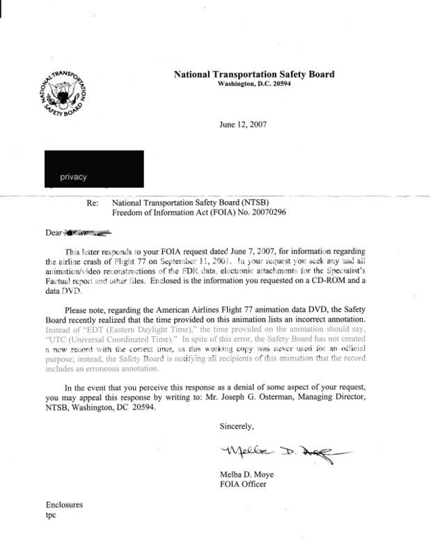
It looks like pretty much the same thing everyone else has been getting, as Rob Balsamo (John Doe X) said I'd get if I asked. The same officer that signed Undertow’s and Snowygrouch’s letters, Melba D. Moye, the same wording, the more recent apology for the wrong time stamp, etc. Sound like the one I’m looking for. It informed me of my recent query, and stated “enclosed is the information you requested on a CD-ROM and a data DVD.” At the bottom are the words “enclosures: tpc,” whatever exactly that means.
So what's on the discs? I don't know. They weren't enclosed. The letter was folded in thirds, placed in a letter-size 8.5x3.75" envelope with nothing else. The envelope was not moisture sealed but secured with clear tape. My address was handwritten, and it had a proper looking address with the warning “official business penalty for private use $300.00” and a handwritten code C10-40 (FOIA).
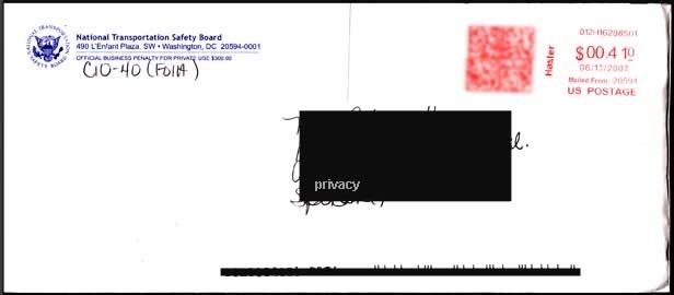 I guessed maybe "enclosed" means in the mail, and started presuming I'd soon have my own copy of the green and purple cartoon with the wrong altitude, wrong lat/long plot, and wrong final bearing that Pilots for 911 Truth and others have been wondering over. But now it seems it’ll be slow in coming, and I’ll have to write in to get this figured out; “In the even that you perceive this response as a denial of some aspect of your request, you may appeal this response by writing” to the NTSB’s managing director Joseph Osterman. They’re all gonna know me real well down there before all this is done.
So while the animation’s direct link to the NTSB remains to be totally verified on my end, the letter sure looks like part of the overall pattern reported so far by FOIA recipients, and it appears I was probably in error for doubting the animation's NTSB pedigree. But strangely, I've been singled out for this silent treatment, some set of factors witholding total confirmation...
NO DISCS ENCLOSED!
Adam Larson/Caustic Logic
The Frustrating Fraud
June 21 2007
Updated 6/26
[Note: This investigation is done under terms of the Freedom of Information Act, requesting documents from the National Transportation Safety Board (NTSB). I was spurrred to it by my suspicions over previous FOIA-obtained NTSB data published by Pilots for 911 Truth. ]
Before I even went the normal FOIA route, I first tried a different strategy, contacting the Public Affairs Department. This effort proved interesting but came to naught. I will write a post about that soon. I followed this up with a Freedom of Information Act request via the online form at the NTSB site:
I am lodging a request for items regarding aircraft no. N644AA American Airlines Flight 77 that crashed on September 11 2001. Items I would like to have sent to me:
1) any and all animations/reconstructions of the FDR data from Flight 77
- a working copy that others have received, including a erroneously-labeled time stamp. (this is available online for visual reference)
- If possible any other animations, like the one presented by the 9/11 Commission in a mid-2004 presentation, aired on C-Span, but for which I can find no information. If this was NTSB-produced and is releasable it would be very useful.
2) electronic attachments listed for the Specialist's Factual report (doc ID DCA01MAO64)
- DCA01MAO64_tabular.csv
- D226A101-3G.pdf
- 757-3b_1.txt
3) Other files:
- AAL77_tabular.csv (if different from CSV listed above)
- Original L3 compressed raw AA77 FDR file
I had despaired on reading "turnaround could range from 3 weeks to 1 year or more," as I filed my request on June 7. The response is dated June 12. It was put in my mailbox on the 15th or 16th while I was out of town and I found it on Sunday the 17th. This swift response paralled two other members at Above Top Secret.com, as well as John Farmer’s receipt at around the same time. Here is the letter I recieved [ny name is redacted here even though it’s on the article header on the off-chance this jpeg gets re-posted all over – my street address is also not something everyone needs to know].
It looks like pretty much the same thing everyone else has been getting, as Rob Balsamo (John Doe X) said I'd get if I asked. The same officer that signed Undertow’s and Snowygrouch’s letters, Melba D. Moye, the same wording, the more recent apology for the wrong time stamp, etc. Sound like the one I’m looking for. It informed me of my recent query, and stated “enclosed is the information you requested on a CD-ROM and a data DVD.” At the bottom are the words “enclosures: tpc,” whatever exactly that means.
So what's on the discs? I don't know. They weren't enclosed. The letter was folded in thirds, placed in a letter-size 8.5x3.75" envelope with nothing else. The envelope was not moisture sealed but secured with clear tape. My address was handwritten, and it had a proper looking address with the warning “official business penalty for private use $300.00” and a handwritten code C10-40 (FOIA).
I guessed maybe "enclosed" means in the mail, and started presuming I'd soon have my own copy of the green and purple cartoon with the wrong altitude, wrong lat/long plot, and wrong final bearing that Pilots for 911 Truth and others have been wondering over. But now it seems it’ll be slow in coming, and I’ll have to write in to get this figured out; “In the even that you perceive this response as a denial of some aspect of your request, you may appeal this response by writing” to the NTSB’s managing director Joseph Osterman. They’re all gonna know me real well down there before all this is done. So while the animation’s direct link to the NTSB remains to be totally verified on my end, the letter sure looks like part of the overall pattern reported so far by FOIA recipients, and it appears I was probably in error for doubting the animation's NTSB pedigree. But strangely, I've been singled out for this silent treatment, some set of factors witholding total confirmation...
Monday, June 4, 2007
NEWS COMING
June 4 2007
I haven't been able to post anything new, update my old posts, or respond to new comments lately, as I've just stumbled into a major hullaballoo about the supposed NTSB flight path animation for Flight 77. In the post TEN DEGREES FROM TRUE: THE "NTSB ANIMATION" IS FLAT WRONG, first done at Above top secret.com the same night (May 27) I outlined my case as to why the animation discrepancy Pilots for 9/11 Truth had used for their video Pandora's Black Box actually worked against the Pilots. This is becuase it is internally inconsistent, showing both a 90 and a 70 degree heading at the same time, and because of it's unclear paper trail and NTSB pedigree.
Frequent references to a "new" animation that popped up during the thread turned out to be another copy of the same animation also said to be from the NTSB. This DVD was recieved May 24 and posted online May 26. Also The Pilots had just re-obtained it themselves, all the same problems and all, this time with a better cover letter and stronger NTSB linkage. The shadow possibility that this blatantly wrong animation is indeed from the officials on high is now directly the possibility I'm looking at, with all that implies or doesn't.
I had no idea all this was happening as I started that thread based on what I knew - oops - and now I'm feeling a bit overwhelmed, as Pilots founder John Doe X is calling me and my cohorts out for not knowing our stuff, and challenging us to contact the NTSB ourselves. But it's too late to turn back now, and the next step is indeed to get some information from the NTSB myself.
So nothing new right now, but this week I'll have something to report.
Subscribe to:
Posts (Atom)


