First Posting
9/24/08, 2am
updated 9/28, 11 pm
Alright, so at the JREF, this "Turbofan" character has been making a lot of noise in Anti-Sophist's FDR thread, criticizing the "pros" there and acting as if he knows everything about Flight data recorders, and along the way hinting at the old Balsamo sticking-point, the refusal of sane people to debate him on the phone. Well, I'm only half-sane, and offered to accept his challenge on condition he send me two dozen homemade cranberry muffins. He unexpectedly took me up, and after a series of PMs where we started out actually haggling over the muffins, we decided on last night. I was at work, but took a break when he called, about 5:45pm, put the speakerphone on, and recorded my fairly down-key conversation with Tino, as he gives his true name. For those familiar with his on-screen persona, so remarkable arrogant and Balsamo-esque, his real-time discussion manner is so much more - Canadian. It's almost like two different people, and the Tino I talked with in fact knew little about FDRs, having only garnered his knowledge from talking with PfffT, and couldn't even cite the values that were so discrepant in the final frame of data. The audio turned out pretty decent, and as soon as I decide a good way to share it, and for good measure confirm his consent to do so, well, then I'll do so, and add some notes and stuff.
---
Here's the audio
Boomp3.com
Additional Notes: [apologies for being so slow. I'm fairly busy elsewhere these days]. Regarding the audio, the line noise came out worse than I though - unshielded cables, please try to ignore. I figure there's no point in arguing for a win with a sock puppet or irrational person who's simply set in their course; as Swift says, via Pomeroo, "you can't reason someone out of something he was never reasoned into." So I may come across soft, but hardness hardly seemed necessary against this underwhelming opponent, and I was speaking to the (hypothetical) reasonable person inside who's ready to stop being led astray. Other notes later.
Showing posts with label Balsamo R. Show all posts
Showing posts with label Balsamo R. Show all posts
Thursday, September 25, 2008

Saturday, June 14, 2008
MORIN: THE CONVENTIONAL WISDOM
MORIN: THE CONVENTIONAL WISDOM
Adam Larson / Caustic Logic
The Frustrating Fraud
June 14 2008 3am
edits update 11pm
Pentagon attack witness Terry Morin, September 2001 at the Navy Annex/FoB #2:
“Approximately 10 steps out from between Wings 4 and 5, I was making a gentle right turn towards the security check-in building just above Wing 4 when I became aware of something unusual.”
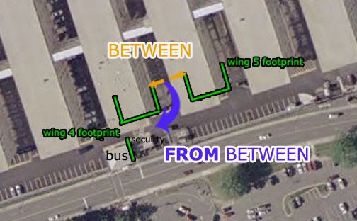 According to this graphic, the larger structure to his right here is the bus stop and the smaller one security (thanks CIT). These sit astride the high-traffic crosswalk to the parking lots across the Pike, including, according to this graphic, lot 3, to which he said he was headed (thanks Bobloblaw).
“I started to hear an increasingly loud rumbling behind me and to my left. As I turned to my left, I immediately realized the noise was bouncing off the 4-story structure that was Wing 5. One to two seconds later the airliner came into my field of view.”
Where exactly and how far out? Officially, southwest, about straight ahead if facing the bus stop. The distance is far from clear, but given that it was traveling at near the speed of sound, it couldn't be much behind its noise, perhaps passing the Sheraton hotel. In the below graphic, the “official” flight path is placed approximately based on all available data, and is a general fit for Morin’s description, below:
 “The aircraft was essentially right over the top of me and the outer portion of the FOB (flight path parallel the outer edge of the FOB).”
The use of ‘essentially’ in conjunction with his otherwise detailed account shows he means it was very nearly over him but not quite. “Parallel” I take as an accurate observation but not necessarily 100% precise. The real path of Flight 77 does in fact run about parallel to the building’s edge, as seen here. Also, parallel is a word describing two different lines. He did not say “along the edge,” so it was probably centered either north or south of that line, and if north, his failing to describe it as over the building is curious.
“I estimate that the aircraft was no more than 100 feet above me (30 to 50 feet above the FOB) in a slight nose down attitude. The plane had a silver body with red and blue stripes down the fuselage. I believed at the time that it belonged to American Airlines, but I couldn’t be sure.”
Seeing stripes indicates, as he said, that it was not directly over him (unless in a severe sideways bank, which neither he nor anyone mentions). It was either some combination of south and banking left (and he’d see the left/port side), or north and banking right (in which case he’d see the right side). The former seemed to fit his continued line-of-sight, nearly up to impact, and of course also fits with where the plane actually was and where Morin said in 2001 that he was. He describes his continuing view thus:
“Within seconds the plane cleared the 8th Wing of BMDO and was heading directly towards the Pentagon. Engines were at a steady high-pitched whine, indicating to me that the throttles were steady and full. I estimated the aircraft speed at between 350 and 400 knots. The flight path appeared to be deliberate, smooth, and controlled. As the aircraft approached the Pentagon, I saw a minor flash (later found out that the aircraft had sheared off a portion of a highway light pole down on Hwy 110). As the aircraft flew ever lower I started to lose sight of the actual airframe as a row of trees to the Northeast of the FOB blocked my view. I could now only see the tail of the aircraft. I believe I saw the tail dip slightly to the right indicating a minor turn in that direction. The tail was barely visible when I saw the flash and subsequent fireball rise approximately 200 feet above the Pentagon.”
His lateral line-of-sight would be set by the edge of the 8th wing’s SE corner. This would completely block his view of anything too far north, and this path does have something of a north trend. His approximate line-of-sight then is represented by the yellow line in my second graphic, above. Note that the last stretch of the path and the impact itself would be invisible from his angle, unless he moved significantly south.
He also specifically mentions a vertical line-of-sight, defined by a row of trees running along the crest of the hill east of the FoB. In the analysis below, descent rate again approximated, the point where he’d lose sight of the plane appears to work out to about the same location – that is, it went too far north to see at about the same time it went too low, all at around the yellow line. I'd venture from these rough renderings that it would disappear below the horizon just before passing behind the building.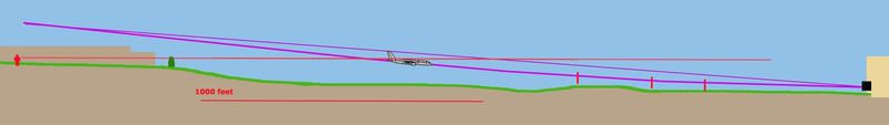 So in two ways he would absolutely not see the plane all the way to impact. The reason I explain this is to defuse the importance of Rob Balsamo’s neat little video using 3-D graphics to show the same thing I decided with my graphics, so it's a useful visualization (scene below) – it shows the plane shrinking to the corner, disappearing vertically just before it was about to do so laterally.
 This revelation fits with the placement above and with Morin's first losing it behind "a row of trees," not the building. It only appears damning and contradictory when contrasted to this line, sometimes misused by ‘de-bunkers’ and here misused by a re-bunker:
“The tail was barely visible when I saw the flash and subsequent fireball rise approximately 200 feet above the Pentagon.” [emph. mine]
First, “when” cannot be taken too literally when micro-second time differences are at work. Second, the flash may be a light pole being “planted,” catching a glint of sunlight as it “danced” in the air. It may have been a glint off the plane itself as it banked, depending on the angles, which I haven’t analyzed. But clearly it occurred in his line-of-sight, and southwest of - before - the “subsequent fireball.” His narrative does put enough detailed emphasis on seeing tail, and “believing” to have, that it appears he’s embellishing a bit. Vagueness of language aside, he is clearly supplementing his memory with additional info (time: "call it approximately 9:36 AM"), and it would seem embellishing some gaps - tiny, tiny gaps. Perhaps it seemed to him that the “official facts” lined up with what he saw and heard, and if so such synergizing is only natural.
So this is the conventional wisdom, or rather my understanding (which is just a notch above that), of Terry Morin’s account. It corroborates the "official story"/real flight path so well in fact, that he's been strenuously dismissed by critics like CIT's Ranke, who back in November rattled off a huge list of perceived inconsistencies and stated paradoxically “due to all of these extreme contradictions with the official story and explicit exaggerated details meant to support it [...] it's clear that Morin is either relaying a completely fabricated or else wildly embellished account.”
Well, if Ranke today is to be believed, simple embellishment is out the window at least, and Morin himself proves that Morin was fabricating virtually everything in his account, possibly in cahoots with the planners who knew how it should look. Ranke says Morin affirmed, in a private, off-the-record discussion recently, that he was actually “between” the wings rather than “from between,” (see first graphic). This is just as CIT had always reasoned against all reason, giving him the view of a toaster pastry that completely invalidates everything above and any reason to believe what he says now.
If Ranke today is to be believed… and that’s an if alright… then Morin the proven fabricator who was likely complicit now helps prove the truth seven years later and “most definitely should go on the list of people to subpoena once the hearings begin.” Once again the mighty CIT has shown us how much we all know. I have some things to say about this ridiculous turn, but I’m taking it steady right now, and will report more fully as soon as it seems reasonable.
Adam Larson / Caustic Logic
The Frustrating Fraud
June 14 2008 3am
edits update 11pm
Pentagon attack witness Terry Morin, September 2001 at the Navy Annex/FoB #2:
“Approximately 10 steps out from between Wings 4 and 5, I was making a gentle right turn towards the security check-in building just above Wing 4 when I became aware of something unusual.”
According to this graphic, the larger structure to his right here is the bus stop and the smaller one security (thanks CIT). These sit astride the high-traffic crosswalk to the parking lots across the Pike, including, according to this graphic, lot 3, to which he said he was headed (thanks Bobloblaw). “I started to hear an increasingly loud rumbling behind me and to my left. As I turned to my left, I immediately realized the noise was bouncing off the 4-story structure that was Wing 5. One to two seconds later the airliner came into my field of view.”
Where exactly and how far out? Officially, southwest, about straight ahead if facing the bus stop. The distance is far from clear, but given that it was traveling at near the speed of sound, it couldn't be much behind its noise, perhaps passing the Sheraton hotel. In the below graphic, the “official” flight path is placed approximately based on all available data, and is a general fit for Morin’s description, below:
“The aircraft was essentially right over the top of me and the outer portion of the FOB (flight path parallel the outer edge of the FOB).”The use of ‘essentially’ in conjunction with his otherwise detailed account shows he means it was very nearly over him but not quite. “Parallel” I take as an accurate observation but not necessarily 100% precise. The real path of Flight 77 does in fact run about parallel to the building’s edge, as seen here. Also, parallel is a word describing two different lines. He did not say “along the edge,” so it was probably centered either north or south of that line, and if north, his failing to describe it as over the building is curious.
“I estimate that the aircraft was no more than 100 feet above me (30 to 50 feet above the FOB) in a slight nose down attitude. The plane had a silver body with red and blue stripes down the fuselage. I believed at the time that it belonged to American Airlines, but I couldn’t be sure.”
Seeing stripes indicates, as he said, that it was not directly over him (unless in a severe sideways bank, which neither he nor anyone mentions). It was either some combination of south and banking left (and he’d see the left/port side), or north and banking right (in which case he’d see the right side). The former seemed to fit his continued line-of-sight, nearly up to impact, and of course also fits with where the plane actually was and where Morin said in 2001 that he was. He describes his continuing view thus:
“Within seconds the plane cleared the 8th Wing of BMDO and was heading directly towards the Pentagon. Engines were at a steady high-pitched whine, indicating to me that the throttles were steady and full. I estimated the aircraft speed at between 350 and 400 knots. The flight path appeared to be deliberate, smooth, and controlled. As the aircraft approached the Pentagon, I saw a minor flash (later found out that the aircraft had sheared off a portion of a highway light pole down on Hwy 110). As the aircraft flew ever lower I started to lose sight of the actual airframe as a row of trees to the Northeast of the FOB blocked my view. I could now only see the tail of the aircraft. I believe I saw the tail dip slightly to the right indicating a minor turn in that direction. The tail was barely visible when I saw the flash and subsequent fireball rise approximately 200 feet above the Pentagon.”
His lateral line-of-sight would be set by the edge of the 8th wing’s SE corner. This would completely block his view of anything too far north, and this path does have something of a north trend. His approximate line-of-sight then is represented by the yellow line in my second graphic, above. Note that the last stretch of the path and the impact itself would be invisible from his angle, unless he moved significantly south.
He also specifically mentions a vertical line-of-sight, defined by a row of trees running along the crest of the hill east of the FoB. In the analysis below, descent rate again approximated, the point where he’d lose sight of the plane appears to work out to about the same location – that is, it went too far north to see at about the same time it went too low, all at around the yellow line. I'd venture from these rough renderings that it would disappear below the horizon just before passing behind the building.
So in two ways he would absolutely not see the plane all the way to impact. The reason I explain this is to defuse the importance of Rob Balsamo’s neat little video using 3-D graphics to show the same thing I decided with my graphics, so it's a useful visualization (scene below) – it shows the plane shrinking to the corner, disappearing vertically just before it was about to do so laterally. This revelation fits with the placement above and with Morin's first losing it behind "a row of trees," not the building. It only appears damning and contradictory when contrasted to this line, sometimes misused by ‘de-bunkers’ and here misused by a re-bunker:“The tail was barely visible when I saw the flash and subsequent fireball rise approximately 200 feet above the Pentagon.” [emph. mine]
First, “when” cannot be taken too literally when micro-second time differences are at work. Second, the flash may be a light pole being “planted,” catching a glint of sunlight as it “danced” in the air. It may have been a glint off the plane itself as it banked, depending on the angles, which I haven’t analyzed. But clearly it occurred in his line-of-sight, and southwest of - before - the “subsequent fireball.” His narrative does put enough detailed emphasis on seeing tail, and “believing” to have, that it appears he’s embellishing a bit. Vagueness of language aside, he is clearly supplementing his memory with additional info (time: "call it approximately 9:36 AM"), and it would seem embellishing some gaps - tiny, tiny gaps. Perhaps it seemed to him that the “official facts” lined up with what he saw and heard, and if so such synergizing is only natural.
So this is the conventional wisdom, or rather my understanding (which is just a notch above that), of Terry Morin’s account. It corroborates the "official story"/real flight path so well in fact, that he's been strenuously dismissed by critics like CIT's Ranke, who back in November rattled off a huge list of perceived inconsistencies and stated paradoxically “due to all of these extreme contradictions with the official story and explicit exaggerated details meant to support it [...] it's clear that Morin is either relaying a completely fabricated or else wildly embellished account.”
Well, if Ranke today is to be believed, simple embellishment is out the window at least, and Morin himself proves that Morin was fabricating virtually everything in his account, possibly in cahoots with the planners who knew how it should look. Ranke says Morin affirmed, in a private, off-the-record discussion recently, that he was actually “between” the wings rather than “from between,” (see first graphic). This is just as CIT had always reasoned against all reason, giving him the view of a toaster pastry that completely invalidates everything above and any reason to believe what he says now.
If Ranke today is to be believed… and that’s an if alright… then Morin the proven fabricator who was likely complicit now helps prove the truth seven years later and “most definitely should go on the list of people to subpoena once the hearings begin.” Once again the mighty CIT has shown us how much we all know. I have some things to say about this ridiculous turn, but I’m taking it steady right now, and will report more fully as soon as it seems reasonable.
Monday, May 19, 2008
THE FLYOVER THEORY GETS SOME FAUX CLOUT
THE FLYOVER THEORY GETS SOME FAUX CLOUT
Adam Larson / Caustic Logic
The Frustrating Fraud
May 19 2008
updated 5/22 1am
Last Thursday night, May 15, saw a remarkable happening of Fraudsterism via the relatively high-profile venue of the Air America radio network and Richard Greene’s Clout program, of which I’d never heard until two days before the show. This tip-off, brought to my attention by an e-mail from a friend, was a press release by Pilots For 9/11 Truth.
05/13/08 - We hope you'll join us regarding the issues surrounding the Pentagon Attack this Thursday, May 15, 2008 at 9pm Eastern on Air America Radio with your host Richard Greene, Co-Produced by Rob Balsamo, Co-Founder, Pilots For 9/11 Truth.
Guest will be:
Craig Ranke from Citizen Investigation Team
Rob Balsamo, Co-Founder, Pilots For 9/11 Truth
Kevin Barret
Individuals supporting the govt story – TBA
[emph mine - original posting]
Background on how Greene and the Pilots hooked up back in March.
For this "Week of Truth" installment, the TBA part wound up meaning, it seems, ‘tiny blocks allowed’ for the only debunker to both be invited and respond, Ron Weick of Hardfire. He took his invitation to a JREF thread but scored no supporters. To hear Balsamo talk they were cringing in fear but really it looks more like skulking and/or sighing in exasperation. I had several good reasons for not getting directly involved, but did try to get a message through to Greene. I urged him to have CIT and PFT on with their promised groundbreaking revelation, but to be aware of my findings about their previous findings. I put the ball in his court, where it already was. If Greene doesn't research his guests, or ignores that they are promoting hoaxes, that's his own problem.
On the other side the list of ‘truthseekers’ invited for the program eventually expanded to include Barbara Honegger, Col. George Nelson, and even the eminent David Ray Griffin was able to take some time to elaborate his decrepit, myopic opinion of the Pentagon attack. Barrett apparently backed up to make room and did not appear, which helped, but… CIT's Aldo Marquis later complained of this over-booking "we are being drowned out. Two many chiefs and not enough Indians. This is why we will fail. We have incredibly important evidence and Ron Weik and Barbara Honegger get more air time than Craig and Rob did. Sucks. All old info all bunk. Whatever, you guys heard it. We've got a flyover witness(es)." [He's not exactly sure if it's plural yet.]Update: the Clout flyover witness
I too was mostly looking to hear the portion where the original guests were featured and this revelation triumphantly ejaculated, but unable to catch it live I had to rely on the later-posted audio links. Ranke and Balsamo were pushed to the last block, the link for which was the only one that didn't work (and still doesn't four days later). Due to delays in getting the segment in question (see below), the review has been delayed. I'll post it separately.
Clout Links:
- Clout episode blog page Entire show minus final segment with CIT and PFT available for listen here, as well as 200+ comments (several by myself and "Hetware" it seems, have been deleted with no explanation).
- Entire show in compressed (poor) wma format, but in one convenient zip file. Provided by Pilots For 9/11 Truth. (theirs is part 1 here, understandably.)
Monday, May 5, 2008
BOBBY BALSAMO CAPTION CONTEST
first posted April 20
last updated 5/5 1 am
At least at the CIT Forum I’m allowed to read any posted attacks against me, unlike at some other forums where one must register their computer with the owners to even read it, which I refuse to do. Craig got mad about my ‘attack’ on a witness he’s about to publish. They offered no link to the actual attack, as they don’t link to ‘disinfo’ and banned me from posting there for being disinfo, of course, as dis-disinfo would be called by disinfo.
He again resorted to my “ego-driven obsession” admission, which I injected into his quote repertoire intentionally as a dye marker to gauge when he really has nothing else to offer.
To prove I said this, he even finally offers a direct link to my 'disinfo.' I've seen it, and can document it. I make a bad point, they call me on it. He's wrong! Here's why. Then I consider that, reformulate and hit back... and suddenly it's either a fluffed-up bluff, an accusation of incoherency (what? I couldn’t hear ya! What?) or failing even that, it’s the ego/obsession thing, or perhaps I’m an “operative” if I’m dealing with Aldo.
And when that stops working it devolves further... PFFFFT and CIT are now so confident of their facts they have resorted to comments about my job, my appearance, my kitchen, and my girlfriend’s 10-year-old son. [link to their stupidity, which I always offer since I trust my readers to decide for themselves].
I was hoping to keep the kid out of all this, and I had a feeling of dread one night recently when I realized I had still been logged into his account when responding to one of Rob’s lying posts on my video page. I hoped he'd be mature enough to leave that alone, but got myself worked up worrying about it for reasons I can’t fully explain, and can’t expect Rob to understand. So of course he passed the link on to CIT who make an animated gif of me where Nick coaxed me to be in one his shorts – getting hit in the head with a ball of clay and falling down like a dork in my messy kitchen. They captioned this with witty lines about me being deceptive and knocked over by CIT’s evidence and shit like that. I chuckled a bit despite myself. They all had a great time, not playin, making fun of my hair and skinniness, whatever. [eh, see them there] Hahaha! I look like dork in my messy kitchen! This is okay since I did this earlier for CIT using Ranke's public picture:

But for my own reasons, I had really been hoping to keep Nick out of this, at least by name, but too late now. What pissed me off most was when Rob, probably belligerent drunk, asked “I wonder if that "Nick" kid was the same "Nick" we were arguing with last year on ATS.” After I had asked him to not drag the kid into it, he said “Adam.. YOU brought the kid into this by having him post on the net (if in fact it was the same Nick. Going by his replies, it sure seemed like a 10 yr old).” [emph mine] Yes Rob. Last year when he was nine I had him argue with you online. He’s a smart kid, just not smart enough to use a screen name other than his own. I brought it down on us. For some reason this whole thing really pissed me off. I told him if we were in the same room I’d punch him in the face. I’m sure he’d win the fight, but still…
update 4/22 nick 7261 argues fine, this is just another insult. perhaps little nick could argue rob down, i dunno, but big nick did well - he was over-zealous and sometimes stupidly wrong, but really smart and biting at moments too.
Rob did correctly point out that it was never top-secret, that “you can scroll through "related videos" on the right margin of your "CausticLogic" videos and find "AdamSonOfLars" and vice versa.” Yes, I never liked that and that’s my fault - but it was somehow never a problem until a couple days after that stupid slip that gave him this opportunity to do some accidental op research. So you got your funny pictures, and whatever else. Account closed, new one if there is will be firmly separated and any further drawing in of my personal life and family into this - should be avoided for many reasons. Harassers for 911 truth doesn't have the same ring...
Stick to the issues please Rob. Still no explanation for what you meant by all those cherries I made that pie out of. Still no (public) correction to your patently ridiculous G-force calcs based on an irrelevant thought exercise. Nothing beyond the word of a FDR salesman that that wrong data is 1 sec or less from the wall, tho we hear you have more evidence somewhere. And how about that airfones thing? You can’t get your own shit together yet you can always find time to sling more insults. Oh, and to go enjoy your water sports.

I mean, I could go off on that stupid picture you slapped me with of your lying fat ass on that waterskiing adventure, sucking up the $$$ that suckers keep sending you for DVDs and barbecue aprons, but that would be side-stepping the issues and engaging in childish personal attacks on your motives and appearance.
But while we all wait for updates and/or admissions, this will help while away the time. First, I’ll let anyone else decide what to put in this balloon. Submit entries in comments section below. I’ll add my own later. Winners will be posted, and recieve nothing more. Then I can call it even and move on to you continuing to ignore and downplay your own lies and not-quite-lies as I finally stop bothering "holding your hand" and trying to walk you towards a more truthful path.
---
update 4/22 I’m less angry now - my girlfriend thinks it's not such a big deal... she's more upset that i deleted the page. I’m new to the sorta-parent thing and was trying a bit too hard with the 'protective' thing. Also Craig, thanks for the tips. you may just be better at parenting advice than at running an 'investigation.' keep trying and you may find your calling.
update 5/5: In fact I have Rob to thank for helping me realize I don't want video accounts tangled and there''s no way it seems if they're even looked at on the same computer. So I'm deleting my Youtube videos and not watching others. Also, the contest is decided after I received Rob's entry as well (see comments below). This is the winner.
last updated 5/5 1 am
At least at the CIT Forum I’m allowed to read any posted attacks against me, unlike at some other forums where one must register their computer with the owners to even read it, which I refuse to do. Craig got mad about my ‘attack’ on a witness he’s about to publish. They offered no link to the actual attack, as they don’t link to ‘disinfo’ and banned me from posting there for being disinfo, of course, as dis-disinfo would be called by disinfo.
He again resorted to my “ego-driven obsession” admission, which I injected into his quote repertoire intentionally as a dye marker to gauge when he really has nothing else to offer.
To prove I said this, he even finally offers a direct link to my 'disinfo.' I've seen it, and can document it. I make a bad point, they call me on it. He's wrong! Here's why. Then I consider that, reformulate and hit back... and suddenly it's either a fluffed-up bluff, an accusation of incoherency (what? I couldn’t hear ya! What?) or failing even that, it’s the ego/obsession thing, or perhaps I’m an “operative” if I’m dealing with Aldo.
And when that stops working it devolves further... PFFFFT and CIT are now so confident of their facts they have resorted to comments about my job, my appearance, my kitchen, and my girlfriend’s 10-year-old son. [link to their stupidity, which I always offer since I trust my readers to decide for themselves].
I was hoping to keep the kid out of all this, and I had a feeling of dread one night recently when I realized I had still been logged into his account when responding to one of Rob’s lying posts on my video page. I hoped he'd be mature enough to leave that alone, but got myself worked up worrying about it for reasons I can’t fully explain, and can’t expect Rob to understand. So of course he passed the link on to CIT who make an animated gif of me where Nick coaxed me to be in one his shorts – getting hit in the head with a ball of clay and falling down like a dork in my messy kitchen. They captioned this with witty lines about me being deceptive and knocked over by CIT’s evidence and shit like that. I chuckled a bit despite myself. They all had a great time, not playin, making fun of my hair and skinniness, whatever. [eh, see them there] Hahaha! I look like dork in my messy kitchen! This is okay since I did this earlier for CIT using Ranke's public picture:
But for my own reasons, I had really been hoping to keep Nick out of this, at least by name, but too late now. What pissed me off most was when Rob, probably belligerent drunk, asked “I wonder if that "Nick" kid was the same "Nick" we were arguing with last year on ATS.” After I had asked him to not drag the kid into it, he said “Adam.. YOU brought the kid into this by having him post on the net (if in fact it was the same Nick. Going by his replies, it sure seemed like a 10 yr old).” [emph mine] Yes Rob. Last year when he was nine I had him argue with you online. He’s a smart kid, just not smart enough to use a screen name other than his own. I brought it down on us. For some reason this whole thing really pissed me off. I told him if we were in the same room I’d punch him in the face. I’m sure he’d win the fight, but still…
update 4/22 nick 7261 argues fine, this is just another insult. perhaps little nick could argue rob down, i dunno, but big nick did well - he was over-zealous and sometimes stupidly wrong, but really smart and biting at moments too.
Rob did correctly point out that it was never top-secret, that “you can scroll through "related videos" on the right margin of your "CausticLogic" videos and find "AdamSonOfLars" and vice versa.” Yes, I never liked that and that’s my fault - but it was somehow never a problem until a couple days after that stupid slip that gave him this opportunity to do some accidental op research. So you got your funny pictures, and whatever else. Account closed, new one if there is will be firmly separated and any further drawing in of my personal life and family into this - should be avoided for many reasons. Harassers for 911 truth doesn't have the same ring...
Stick to the issues please Rob. Still no explanation for what you meant by all those cherries I made that pie out of. Still no (public) correction to your patently ridiculous G-force calcs based on an irrelevant thought exercise. Nothing beyond the word of a FDR salesman that that wrong data is 1 sec or less from the wall, tho we hear you have more evidence somewhere. And how about that airfones thing? You can’t get your own shit together yet you can always find time to sling more insults. Oh, and to go enjoy your water sports.
I mean, I could go off on that stupid picture you slapped me with of your lying fat ass on that waterskiing adventure, sucking up the $$$ that suckers keep sending you for DVDs and barbecue aprons, but that would be side-stepping the issues and engaging in childish personal attacks on your motives and appearance.
But while we all wait for updates and/or admissions, this will help while away the time. First, I’ll let anyone else decide what to put in this balloon. Submit entries in comments section below. I’ll add my own later. Winners will be posted, and recieve nothing more. Then I can call it even and move on to you continuing to ignore and downplay your own lies and not-quite-lies as I finally stop bothering "holding your hand" and trying to walk you towards a more truthful path.
---
update 4/22 I’m less angry now - my girlfriend thinks it's not such a big deal... she's more upset that i deleted the page. I’m new to the sorta-parent thing and was trying a bit too hard with the 'protective' thing. Also Craig, thanks for the tips. you may just be better at parenting advice than at running an 'investigation.' keep trying and you may find your calling.
update 5/5: In fact I have Rob to thank for helping me realize I don't want video accounts tangled and there''s no way it seems if they're even looked at on the same computer. So I'm deleting my Youtube videos and not watching others. Also, the contest is decided after I received Rob's entry as well (see comments below). This is the winner.
Friday, April 25, 2008
NTSB'S "GOEBBELS" AND ME
NTSB'S "GOEBBELS" AND ME
Adam Larson / Caustic Logic
The Frustrating Fraud
April 24 2008
Previously I have written on my reasons for contacting the NTSB over Flight 77 FDR data, and on the empty envelope I got for my FOIA pains. But for some reason, I never did post the results of the middle part where I contacted the Safety Board’s Public Affairs dep’t. I did mention it once or twice but have never explained in detail or showed the e-mails. I didn’t include it in my FOIA video, which would have made it even more boring. So it came across like a bit of an ambush when I first posted this stuff at Above Top Secret.com the other day after Rob Balsamo/johndoex said:
“This is almost as good as when CL refused to contact the NTSB when he accused us of fabricating the animation.”
He knows damn well that I contacted them if not the full story. Perhaps he thinks I made it all up. But for the record, I’m still surprised how quickly I contacted them, considering what a procrastinator I usually am. I started my first animation/FDR-centered ATS thread on May 27 last year, with my initial well-founded (but ultimately wrong) doubts over the animation’s authenticity. I first found undeniable evidence of NTSB pedigree late on May 29 (Slob’s video posting at Google), and then found more info over the next few days, which had people saying the ball was in my court - time to try it myself.
Even though it’s not my normal thing, I decide to try a unique approach and start with the public affairs department, hoping to score a ‘media liaison’ to help from the inside. It was on the afternoon of June 6th that I called them and talked to a guy named Ted Lopatkiewicz (it’s pronounce lo-pat-ke-wikz, for those who have a hard time), who I later found is the department director, and whom Balsamo has called 'the Joseph Goebbels of the NTSB.' I don’t know why he answered the phone instead of some subordinate, but not even knowing who he was, I got tongue-tied, and followed up with an e-mail at his request. [I considered recording the call, but figured I’d be even more nervous that way, plus I was trying for the human touch as opposed to the legalistic.] Later that night, I filed an online FOIA request for good form and then fired off an e-mail, sent June 7 at 2:37 am. It read as follows:
---
Director Lopatkiewicz
My name is Adam Larson, the guy with the 9/11 questions who spoke with you briefly yesterday afternoon. I’m not sure it’s normal to have reached the director of the office directly, and I’m a bit embarrassed, so right to the point:
I’m sure you’re used to precise questions, but mine are actually many and varied. They regard the flight data recorder from aircraft no. N644AA, American Airlines Flight 77, that of course hit the Pentagon on September 11 2001. I’ve been researching the subject for quite a while, starting as a “conspiracy theorist” looking into what I first thought were silly claims that no plane had hit the building. On closer inspection, I found the claims were even sillier than I thought.
Recently I’ve turned to looking into the Flight Data recorder to see what it can tell us, but have run into widespread confusion. I am fairly conversant with the issues, the publicly available information, like the “Specialist’s Factual Report,” which I have studied closely, and the general outlines of FBI vs. NTSB mandates. My technical questions regard not so much the actual data though as information about the data – questions about information previously released by the NTSB under the Freedom Of Information Act; specific pieces of evidence that have been made public but remain poorly documented. A person who knows the data well would be good to talk to, help me compare files, or anything of that nature, and perhaps you or your office could at least help point me in a fruitful direction.
That is I have definite questions, but first I need to know if this is the office for me. After reviewing the options, I’ve decided it is my best hope. The website explains Public Affairs “Provides […] point-of-contact liaisons for news media representatives.” I’m not exactly news media but am a journalist of sorts in that I run a 'blog and am active in discussion forums and generally respected within my narrow field of focus.
The issue at hand, and the reason I contact you, is that there are some questions about apparently erroneous data attributed back to the NTSB that is causing a lot of confusion in the public at the moment. I believe it’s in the Safety board’s interest to actively help me, and the public, sort this out a little bit. I’m not looking for an explanation, just any additional information that can be had to help shed light on the situation.
I’m also doing what I can through normal FOIA channels, but there is only so much I can actually find out that way, and so am exploring this possibility as well.
I'm sorry if I'm terribly off-base in my request. Thank you for your time and consideration.
Sincerely,
Adam J. Larson
Spokane, WA
---
As Rob and Jeff Hill and others found, they aren't answering questions. The director responded right before lunch the next day, 11:53 am:
---
Mr. Larson:
As I explained to you when you called me yesterday, the National Transportation Safety Board provided technical support to the federal government's investigation into the terrorist attacks on September 11, which was conducted by the Federal Bureau of Investigation. Among the assistance we provided were identification of aircraft parts and read-outs of flight recorders recovered from the Pentagon and Pennsylvania sites (we understand no recorders were recovered from Ground Zero). Because this was not a Safety Board investigation,
it would be improper for us to discuss investigative findings. We did release, under provisions of the Freedom of Information Act, some of the factual information that we provided to the FBI; as you are aware, that information is
available on our website. Any interpretation or explanation of those data would
have to be rendered by the FBI.
Thank you for contacting me, and good luck on your project.
Ted Lopatkiewicz
---
So the NTSB are the ones who made this messed up data, but since they turned it over the FBI, it’s the FBI, who know nothing about how it was rendered, that I’d need to ask. I also recall responding to this letter but don’t seem to have saved it. It was something short and sweet to the effect of ‘thanks for nothing.’ I could have pushed it, but I‘ve seen how much good that’s done others – some fodder for the ‘9/11 truth radio’ shock jocks is all; “listen to that evasiveness in the face of belligerence!” They’re the same with the timid as well I found with my experiment, and being timid, I had double reason not to push it.
Then I just waited and got the same letter everyone else did talking about the same enclosed discs only without the discs, and THEN I just looked at it and figure out the part that most interested me, the north flight path, and proved it was caused only by a grid/map rotation, with no help from either NTSB or PFFFT. All else that seems off with the last frame of data I’m chalking up to last frame recorded thousands of feet away, followed by missing seconds of data, of whatever length makes most sense. That ball is out of my court. So that's the missing chapter in all the detail it's worth or more.
Friday, April 11, 2008
A CHERRY PIE FROM ROB’S ORCHARD
A CHERRY PIE FROM ROB’S ORCHARD
Adam Larson / Caustic Logic
The Frustrating Fraud
April 10 2008
last updates 4/16
Picking?
My recent Youtube video That Darn NTSB cartoon, part 1, featured Rob Balsamo/Johndoex vocally promoting north path ‘data’ supposedly from Flight 77’s black box and ‘corroborated by Pentagon police officers…” I was explaining the issue and working up to a video explaining my previous findings that the ‘north plot data’ was just an illusion created by turning the final map the wrong way, which I had always taken him as denying. Balsamo left a comment: ”lol... this has to be the worst case of cherry picking i have ever seen. Bravo CL, you have out done yourself.”
I responded “if I'm picking cherries that implies I'm ignoring things. Regarding my analysis of the FDR north path, using YOUR OWN words, what am I ignoring? The actual 'north plot data?' Or what?” His explanation was interesting, “CL, we have been saying the "map may be rotated" since Aug 2006.” I didn’t recall that ever seeing them say anything like that, but spurred by this comment, I did look around a bit and am left asking “Cherry picking? What else should a cherry-hungering blogger do when he finds himself in a friggin’ cherry orchard? Dig around for a raspberry bush?”
Did he or some other member say once, somewhere, the "map may be rotated"? Probably so since he put it in quotes and gave it a date, and they say a lot of things – the question is how, when, where, how often? Is this the impression that comes through? Where can I read/hear these thoughts? “Clearly you don’t remember when I told you the same thing during our first exchange,” he tipped me off. I did miss this first time around, and going back to the passages he likely means here, from my thread at Above Top Secret.com, I see why. I’ll cover this at the end; first the cherries. This is not a perfect sampling by a long-shot, but I have enough cherries for a whole pie. I have less fresh ones than fermented vintage from his earlier activist phase before he was banned everywhere. I was made more familiar along the way with his well-known tactics of appeal to expertise, to their impressive roster, distractions and insults, pretending his opponents are all stupid and lazy, lengthy irrelevant re-posts and links, links, links… Clearly he enjoys being banned, and values true discussion roughly nil.
The Issue: Headings and Rotations
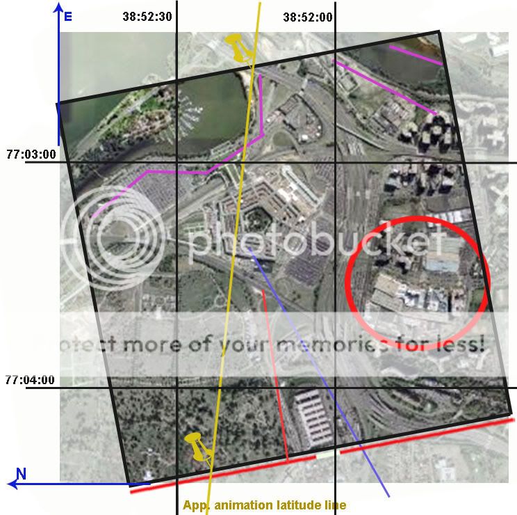
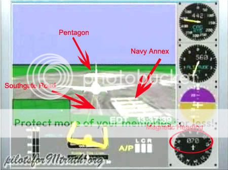 First, to understand the significance of any of this, one must understand somewhat the heading/map issue. The simplest way to explain this is with this on-screen discrepancy – the heading dial (lower right) reads 70, meaning degrees from the magnetic pole, which corresponds with the FDR-recorded heading. Considering magnetic declination in the area at that time of 10.08° this means a path about 60° from the true north pole, which closely matches the physical damage path before and into the Pentagon. To end at impact, a line on this heading would have to pass south of the Navy Annex and Citgo gas station, where the light poles were severed. The path that we see on the screen however passes well north of the Annex, the Citgo, and the poles, on a heading relative to landmarks that has been multiple-verified by everyone as about 78-80° real, so 88-90° magnetic. So in the picture above, the heading dial and the visual path do not match; one of them must be wrong. [more info here] Either the ground map is rotated wrong while the plane’s movements are accurate to the data, or the ground clues are accurate to the data with the heading dial and all other data altered to cover this up.
Considering the first option matches the rest of the more raw data, nearly matches the physical damage path (for heading) and as I’ve shown is visually verifiable as being the case to anyone who takes the time, the answer is clear.
The alternative - they altered the data to fool us but forgot to alter one rendering of it – the cartoon, the only version most people could see an understand - is of course worth considering but seems a bit silly. That would be like writing a screenplay, filming the movie, deciding you don’t want people seeing it, re-writing the screenplay, then sending the new screenplay out to theaters while slipping in the original movie that was never re-done. Ready to launch a fledgling Truth group to stardom…
The Orchard
I stand accused of distorting Rob’s claims to make him out as unquestioningly supporting the second hypothesis when, in fact, he’s always remained open-minded on the rotation issue. This is what I found, in chronological order except two dates covered at the end. Remember we're mostly discussing the screen here, the visual animated path and the heading dial. Which has he cast more doubt on?
8/24/06, on first posting of the animation’s final maneuver, “About This Video This is the final maneuver performed by the aircraft which hit the Pentagon on September 11, 2001. This animation was provided by the NTSB and is accurate in terms of the flight data recorder on board this aircraft.” No mention or notice yet of the north path aspect which, other than location of the final map, is all that really conflicts. The altitude is about right, which was his point. [source]
11/28/06, Democratic Underground: “When we first received the animation, i had thought perhaps the NTSB messed up on the graphical presentation as well (we went over this briefly on today's Jack Blood broadcast). However, if you look at the initial phases of flight (particularly the take off), it is lined up perfectly with the taxiways and runway as the aircraft taxi's out for take off. Also, we have further evidence which confirms the flight path.. including witnesses, which will be put together in a report. […] The facts conflict with the official fairy tale. […] the professionals at the NTSB dont make mistakes in terms of magnetic variation (as shown in the initial phases of flight).” [source]
3/27/07 at the Loose Change Forum: “Heading indicator altered to match southern approach... however plot confirms North of Citgo testimony given by Pentagon Police Officers. (Please try not to delete this if you want truth)” [source]
5/9/07 – Micheal Herzog interview, RBN “the NTSB data, the plot, the animation that they plot out, has it on the north side of that Citgo gas station […] The north path that we’ve been trying to get answers for, from the NTSB and FBI, is also corroborated by Pentagon police officers, filmed on location, betting their life on it that it was on that side of the gas station. […] [The PentaCon] corroborates the flight data recorder as far as the flight path being north… I mean, right there, it’s dead to rights, right there that the investigation needs to be opened.”
6/4/07 – first comments at ATS, special treatment below: “The heading (in the little instrument) was altered, to confuse the average layman and to grab suckers to buy the official story and the fact the professionals at the NTSB 'screwed up' in their plot.”
6/7/07: “Fact - The NTSB plotted the aircraft north of the govt story flight path” [source]
6/8/07 more at ATS.com, as with 6/4, see below: he mentions that at one point, “i had thought the NTSB may have screwed up a bit and rotated the map a bit.”
7/31/07 e-mail: “Im not trying to sound derrogotory here, but do you happen to have a learning disorder? […] as a side note, the map isnt rotated, and the heading in the csv file does not line up with the physical damage.”
8/3/07 e-mail: Q: You're sure the final map isn't rotated relative to the background lines? A: “Put Google Earth into the same perspective as NTSB animation map with grid lines (you satisfied yet that the animation is from the NTSB? lol), lat/long on ground. You will see very little difference in angles.” [wrong - the difference is exactly that seen between the animation path and heading dial - about 17 degrees]
 [ahem...]
9/19/07, e-mail: “The map isnt rotated. We are not sure exactly how the NTSB made their plot as they are refusing to answer any questions. […] The only thing that doesnt correspond is the heading in the heading indicator at end of flight in which John Farmer did a great job locating the alterations.” [note: Farmer no longer holds this view (it was a 'first guess') and thinks johndoex is a kook - my words, not his].
9/24/07, Above Top Secret: "I'll let you in on a little secret. It doesnt matter if the map is rotated or not. We are not arguing that fact in the latest 3D animation. [...] The map rotation just isnt that important, especially since we place the aircraft on 61.2 degrees and it still doesnt account for physical damage." [source]
4/?/08: “CL, we have been saying the "map may be rotated" since Aug 2006.”
initial doubts
As the two bolded examples show, johndoex had indeed, at one time, been wiling to entertain the obvious and proven conclusion. As the rest of the text above shows, he quickly stopped believing in it for some reason. As I started my thread at Above Top Secret.com alerting people, clumsily I confess, to the discrepancy that challenged the north path 'data' in late May 2007, Rob weighed in on June 4. I hadn't yet decided the map was rotated, but that was seeming the most likely.
“Havent read this thread... but heres a reply from P4T Co-Founder.” He linked to where he had just explained elsewhere “the headings in the csv file and animation were altered... The NTSB plotted the animation from take off on runway 30 at Dulles to end of recording based on lat/long (see the grid on the ground? See the yellow poles extending from the aircraft to the ground? Yeah.. thats a plot). The heading (in the little instrument) was altered, to confuse the average layman and to grab suckers to buy the official story and the fact the professionals at the NTSB 'screwed up' in their plot.” In other words, the final animation map is the ONLY real clue to heading, not nan error, and so all other data from the dial to the FDR decodes that show the same, were altered. He also summarized “the animation heading (instrument reading) was altered to show a southern approach. If the heading wasnt altered it would show 090 Mag or 080 True. Just as the plot shows to the north of Citgo.”
A few days later on the 8th, he posted for us all a rundown of his thinking on the flight path discrepancy, “in a nut shell, the timeline, files, how they were obtained. the making of small video clips on youtube.. the introduction and reasons why to start questioning the flight path instead of thinking it was an error.. and the making of our film.” They started by deciding the animations truly was NTSB, despite no paper trail, because it matched the other data they put out. After this, they quickly noticed that it didn’t match, which is what made this proven NTSB product so interesting of course.
“We noticed the flight path right away that it was off in the animation. We didnt pursue it initially because i had thought the NTSB may have screwed up a bit and rotated the map a bit. So we proceeded with altitude and the like... remember.. its late august 2006. Then i made a video regarding the final maneuver and lack of intercept... you probably seen it.. many have. .Dated Aug 24, 2006. (note, we arent even worried about the flight path at this point because we think the map is rotated) […] meanwhile.. Craig and Aldo were working on their research. .went to DC.. etc. They came back and said "We have a witness who places the plane North of the Citgo!".. And i said.. well great.. now the flight path goes into the rest of the conflicts with official story.. and a new video was born...”
So that's it. It looked like an error, but some external ‘witnesses’ and all they have to do with data translation issues shifted the analysis of the FDR. Gov't-supplied witnesses that match something that’s likely an error in gov’t-supplied data should raise red flags. Rob sees a red flag and charges. Now the video screen is real and all reality rotated around it. Rob, I’m sure you’ll see this sooner or later; feel free to show me your more reasonable side in action. I'm not listening to any more interviews or registering for your forum just to fish for quotes. But this sampling here don’t look too good. You tacitly and indirectly admit now that the map is probably just rotated, and point out that you suspected that at first. So what went wrong in between? Hm?
---
updates:
4/12: I forgot to include this line from his comments on my video page:
"Yes, later i had made the statement that the "map is not rotated" via email which you promptly posted on your blog, despite the numerous interviews i have done to the contrary. Think about that.. :-)"
Yeah, I started thinking about that and that's how this post came to be. Mr. Hyde, please quit telling me you're also some reasonable Dr. Jekyl, somewhere, in the interview I can't find, when you've been running around saying shit like that posted above.
4/16: New quote, e-mail Rob sent out a while back to someone else and saw fit to share with me:
"Map rotation is pretty much what we been saying since day 1 and have said on almost every radio and TV interview. We thought the map was rotated when we first got the animation, that is why we worked on [other issues...] The flight path is secondary and [...] the other issues are primary. [...] We did briefly look into the rotation [...] which it appeared the map was not rotated, and eventually were going to look into it more thoroughly. But since CIT has found new witnesses to a DRA (Down The River) approach, i dont think we are going to bother much more with the flight path and leave that up to the people who were there and actually saw it.
[...] we later included the flight path in our "Questions to the US Govt" on our pentagon page because there are many independent north side witnesses (we wouldnt have even bothered with the flight path had there not been any NOC witnesses).
The professionals at the NTSB just dont "rotate" maps by mistake. They do these types of animations on a regular basis. Since there are so many NOC witnesses, perhaps someone (a whistleblower?) at the NTSB rotated the map intentionally to get people looking into a north of citgo approach? Who knows...." [emph mine - I tend to agree, which is part of why I'm looking into this][source]
The witness-proven east of the river bs thing is not proven at all but what Balsamo is saying here is ALL the FDR data is out the window now - an obvious fake since it doesn't match the witnesses. (who essentially don't exist - one odd, vague guy and some misread other evidence, etc...).
So it was rotated, and probably not on accident. Rob and I seem to be agreeing on this. A backwards mag rotation might make sense, but man what sloppy work. But seven degrees? The JREFfer types will have to think of their own explanations. Step two... hmmm.
Adam Larson / Caustic Logic
The Frustrating Fraud
April 10 2008
last updates 4/16
Picking?
My recent Youtube video That Darn NTSB cartoon, part 1, featured Rob Balsamo/Johndoex vocally promoting north path ‘data’ supposedly from Flight 77’s black box and ‘corroborated by Pentagon police officers…” I was explaining the issue and working up to a video explaining my previous findings that the ‘north plot data’ was just an illusion created by turning the final map the wrong way, which I had always taken him as denying. Balsamo left a comment: ”lol... this has to be the worst case of cherry picking i have ever seen. Bravo CL, you have out done yourself.”
I responded “if I'm picking cherries that implies I'm ignoring things. Regarding my analysis of the FDR north path, using YOUR OWN words, what am I ignoring? The actual 'north plot data?' Or what?” His explanation was interesting, “CL, we have been saying the "map may be rotated" since Aug 2006.” I didn’t recall that ever seeing them say anything like that, but spurred by this comment, I did look around a bit and am left asking “Cherry picking? What else should a cherry-hungering blogger do when he finds himself in a friggin’ cherry orchard? Dig around for a raspberry bush?”
Did he or some other member say once, somewhere, the "map may be rotated"? Probably so since he put it in quotes and gave it a date, and they say a lot of things – the question is how, when, where, how often? Is this the impression that comes through? Where can I read/hear these thoughts? “Clearly you don’t remember when I told you the same thing during our first exchange,” he tipped me off. I did miss this first time around, and going back to the passages he likely means here, from my thread at Above Top Secret.com, I see why. I’ll cover this at the end; first the cherries. This is not a perfect sampling by a long-shot, but I have enough cherries for a whole pie. I have less fresh ones than fermented vintage from his earlier activist phase before he was banned everywhere. I was made more familiar along the way with his well-known tactics of appeal to expertise, to their impressive roster, distractions and insults, pretending his opponents are all stupid and lazy, lengthy irrelevant re-posts and links, links, links… Clearly he enjoys being banned, and values true discussion roughly nil.
The Issue: Headings and Rotations
First, to understand the significance of any of this, one must understand somewhat the heading/map issue. The simplest way to explain this is with this on-screen discrepancy – the heading dial (lower right) reads 70, meaning degrees from the magnetic pole, which corresponds with the FDR-recorded heading. Considering magnetic declination in the area at that time of 10.08° this means a path about 60° from the true north pole, which closely matches the physical damage path before and into the Pentagon. To end at impact, a line on this heading would have to pass south of the Navy Annex and Citgo gas station, where the light poles were severed. The path that we see on the screen however passes well north of the Annex, the Citgo, and the poles, on a heading relative to landmarks that has been multiple-verified by everyone as about 78-80° real, so 88-90° magnetic. So in the picture above, the heading dial and the visual path do not match; one of them must be wrong. [more info here] Either the ground map is rotated wrong while the plane’s movements are accurate to the data, or the ground clues are accurate to the data with the heading dial and all other data altered to cover this up. Considering the first option matches the rest of the more raw data, nearly matches the physical damage path (for heading) and as I’ve shown is visually verifiable as being the case to anyone who takes the time, the answer is clear.
The alternative - they altered the data to fool us but forgot to alter one rendering of it – the cartoon, the only version most people could see an understand - is of course worth considering but seems a bit silly. That would be like writing a screenplay, filming the movie, deciding you don’t want people seeing it, re-writing the screenplay, then sending the new screenplay out to theaters while slipping in the original movie that was never re-done. Ready to launch a fledgling Truth group to stardom…
The Orchard
I stand accused of distorting Rob’s claims to make him out as unquestioningly supporting the second hypothesis when, in fact, he’s always remained open-minded on the rotation issue. This is what I found, in chronological order except two dates covered at the end. Remember we're mostly discussing the screen here, the visual animated path and the heading dial. Which has he cast more doubt on?
8/24/06, on first posting of the animation’s final maneuver, “About This Video This is the final maneuver performed by the aircraft which hit the Pentagon on September 11, 2001. This animation was provided by the NTSB and is accurate in terms of the flight data recorder on board this aircraft.” No mention or notice yet of the north path aspect which, other than location of the final map, is all that really conflicts. The altitude is about right, which was his point. [source]
11/28/06, Democratic Underground: “When we first received the animation, i had thought perhaps the NTSB messed up on the graphical presentation as well (we went over this briefly on today's Jack Blood broadcast). However, if you look at the initial phases of flight (particularly the take off), it is lined up perfectly with the taxiways and runway as the aircraft taxi's out for take off. Also, we have further evidence which confirms the flight path.. including witnesses, which will be put together in a report. […] The facts conflict with the official fairy tale. […] the professionals at the NTSB dont make mistakes in terms of magnetic variation (as shown in the initial phases of flight).” [source]
3/27/07 at the Loose Change Forum: “Heading indicator altered to match southern approach... however plot confirms North of Citgo testimony given by Pentagon Police Officers. (Please try not to delete this if you want truth)” [source]
5/9/07 – Micheal Herzog interview, RBN “the NTSB data, the plot, the animation that they plot out, has it on the north side of that Citgo gas station […] The north path that we’ve been trying to get answers for, from the NTSB and FBI, is also corroborated by Pentagon police officers, filmed on location, betting their life on it that it was on that side of the gas station. […] [The PentaCon] corroborates the flight data recorder as far as the flight path being north… I mean, right there, it’s dead to rights, right there that the investigation needs to be opened.”
6/4/07 – first comments at ATS, special treatment below: “The heading (in the little instrument) was altered, to confuse the average layman and to grab suckers to buy the official story and the fact the professionals at the NTSB 'screwed up' in their plot.”
6/7/07: “Fact - The NTSB plotted the aircraft north of the govt story flight path” [source]
6/8/07 more at ATS.com, as with 6/4, see below: he mentions that at one point, “i had thought the NTSB may have screwed up a bit and rotated the map a bit.”
7/31/07 e-mail: “Im not trying to sound derrogotory here, but do you happen to have a learning disorder? […] as a side note, the map isnt rotated, and the heading in the csv file does not line up with the physical damage.”
8/3/07 e-mail: Q: You're sure the final map isn't rotated relative to the background lines? A: “Put Google Earth into the same perspective as NTSB animation map with grid lines (you satisfied yet that the animation is from the NTSB? lol), lat/long on ground. You will see very little difference in angles.” [wrong - the difference is exactly that seen between the animation path and heading dial - about 17 degrees]
[ahem...]9/19/07, e-mail: “The map isnt rotated. We are not sure exactly how the NTSB made their plot as they are refusing to answer any questions. […] The only thing that doesnt correspond is the heading in the heading indicator at end of flight in which John Farmer did a great job locating the alterations.” [note: Farmer no longer holds this view (it was a 'first guess') and thinks johndoex is a kook - my words, not his].
9/24/07, Above Top Secret: "I'll let you in on a little secret. It doesnt matter if the map is rotated or not. We are not arguing that fact in the latest 3D animation. [...] The map rotation just isnt that important, especially since we place the aircraft on 61.2 degrees and it still doesnt account for physical damage." [source]
4/?/08: “CL, we have been saying the "map may be rotated" since Aug 2006.”
initial doubts
As the two bolded examples show, johndoex had indeed, at one time, been wiling to entertain the obvious and proven conclusion. As the rest of the text above shows, he quickly stopped believing in it for some reason. As I started my thread at Above Top Secret.com alerting people, clumsily I confess, to the discrepancy that challenged the north path 'data' in late May 2007, Rob weighed in on June 4. I hadn't yet decided the map was rotated, but that was seeming the most likely.
“Havent read this thread... but heres a reply from P4T Co-Founder.” He linked to where he had just explained elsewhere “the headings in the csv file and animation were altered... The NTSB plotted the animation from take off on runway 30 at Dulles to end of recording based on lat/long (see the grid on the ground? See the yellow poles extending from the aircraft to the ground? Yeah.. thats a plot). The heading (in the little instrument) was altered, to confuse the average layman and to grab suckers to buy the official story and the fact the professionals at the NTSB 'screwed up' in their plot.” In other words, the final animation map is the ONLY real clue to heading, not nan error, and so all other data from the dial to the FDR decodes that show the same, were altered. He also summarized “the animation heading (instrument reading) was altered to show a southern approach. If the heading wasnt altered it would show 090 Mag or 080 True. Just as the plot shows to the north of Citgo.”
A few days later on the 8th, he posted for us all a rundown of his thinking on the flight path discrepancy, “in a nut shell, the timeline, files, how they were obtained. the making of small video clips on youtube.. the introduction and reasons why to start questioning the flight path instead of thinking it was an error.. and the making of our film.” They started by deciding the animations truly was NTSB, despite no paper trail, because it matched the other data they put out. After this, they quickly noticed that it didn’t match, which is what made this proven NTSB product so interesting of course.
“We noticed the flight path right away that it was off in the animation. We didnt pursue it initially because i had thought the NTSB may have screwed up a bit and rotated the map a bit. So we proceeded with altitude and the like... remember.. its late august 2006. Then i made a video regarding the final maneuver and lack of intercept... you probably seen it.. many have. .Dated Aug 24, 2006. (note, we arent even worried about the flight path at this point because we think the map is rotated) […] meanwhile.. Craig and Aldo were working on their research. .went to DC.. etc. They came back and said "We have a witness who places the plane North of the Citgo!".. And i said.. well great.. now the flight path goes into the rest of the conflicts with official story.. and a new video was born...”
So that's it. It looked like an error, but some external ‘witnesses’ and all they have to do with data translation issues shifted the analysis of the FDR. Gov't-supplied witnesses that match something that’s likely an error in gov’t-supplied data should raise red flags. Rob sees a red flag and charges. Now the video screen is real and all reality rotated around it. Rob, I’m sure you’ll see this sooner or later; feel free to show me your more reasonable side in action. I'm not listening to any more interviews or registering for your forum just to fish for quotes. But this sampling here don’t look too good. You tacitly and indirectly admit now that the map is probably just rotated, and point out that you suspected that at first. So what went wrong in between? Hm?
---
updates:
4/12: I forgot to include this line from his comments on my video page:
"Yes, later i had made the statement that the "map is not rotated" via email which you promptly posted on your blog, despite the numerous interviews i have done to the contrary. Think about that.. :-)"
Yeah, I started thinking about that and that's how this post came to be. Mr. Hyde, please quit telling me you're also some reasonable Dr. Jekyl, somewhere, in the interview I can't find, when you've been running around saying shit like that posted above.
4/16: New quote, e-mail Rob sent out a while back to someone else and saw fit to share with me:
"Map rotation is pretty much what we been saying since day 1 and have said on almost every radio and TV interview. We thought the map was rotated when we first got the animation, that is why we worked on [other issues...] The flight path is secondary and [...] the other issues are primary. [...] We did briefly look into the rotation [...] which it appeared the map was not rotated, and eventually were going to look into it more thoroughly. But since CIT has found new witnesses to a DRA (Down The River) approach, i dont think we are going to bother much more with the flight path and leave that up to the people who were there and actually saw it.
[...] we later included the flight path in our "Questions to the US Govt" on our pentagon page because there are many independent north side witnesses (we wouldnt have even bothered with the flight path had there not been any NOC witnesses).
The professionals at the NTSB just dont "rotate" maps by mistake. They do these types of animations on a regular basis. Since there are so many NOC witnesses, perhaps someone (a whistleblower?) at the NTSB rotated the map intentionally to get people looking into a north of citgo approach? Who knows...." [emph mine - I tend to agree, which is part of why I'm looking into this][source]
The witness-proven east of the river bs thing is not proven at all but what Balsamo is saying here is ALL the FDR data is out the window now - an obvious fake since it doesn't match the witnesses. (who essentially don't exist - one odd, vague guy and some misread other evidence, etc...).
So it was rotated, and probably not on accident. Rob and I seem to be agreeing on this. A backwards mag rotation might make sense, but man what sloppy work. But seven degrees? The JREFfer types will have to think of their own explanations. Step two... hmmm.
Tuesday, March 18, 2008
OBSTACLE? IMPOSSIBLE.
OBSTACLE? IMPOSSIBLE.
WHY THIS ANTENNA THING IS A NON-ISSUE
Adam Larson / Caustic Logic
The Frustrating Fraud
March 18 2008
last update 3/23 3am
Okay, so here’s my response to Rob Balsamo’s new masterpiece Arlington Topography, Obstacles Make American 77 Final Leg Impossible. Yet again, we hear, some things taken together with other things have again proven the official story of the Pentagon attack is physically impossible. He dated the piece March 13 so he could say dramatically “"Beware The Ides Of March" could not be a more appropriate introduction to this article as it appears the government story regarding the events at the pentagon is officially dead.” Again the merry-go-round spins and in the end… again…. everyone disagrees still. I weary of this game, and this latest seems really a pathetic attempt. But it is in my area and people have asked my opinion, so I guess I need to cover it.
After infinite CIT re-posts of Pilots for Truth misfindings, it seems it was Rob Balsamo’s turn to catch them back. “Thanks to the hard work done by Citizen Investigation Team, they alerted us to review figures regarding topography and obstacles along the flight path of American 77 according to the government story. […] According to the government, American 77 final approach to the pentagon is depicted below.”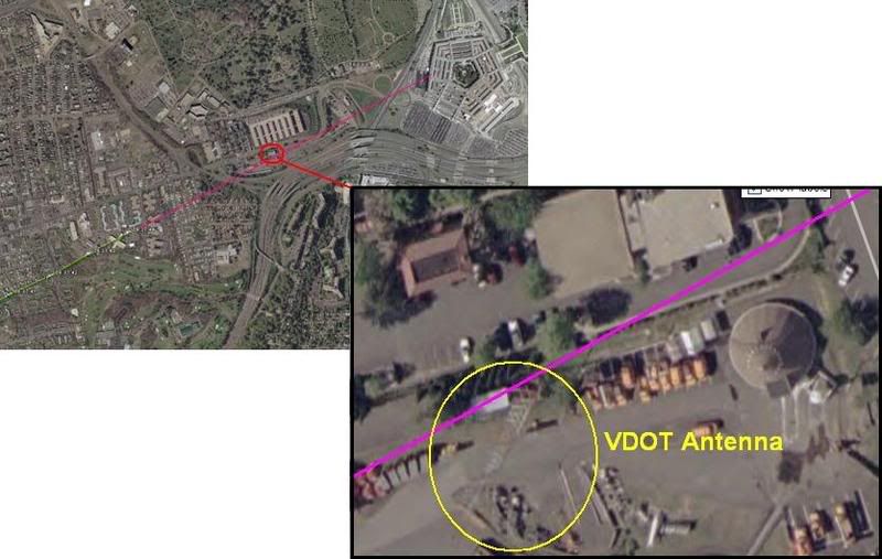
This graphic is not produced by the government, but by Merc Mercy CIT. I’m sure it’s fairly close to accurate, but is it close enough to say where the plane was relative to this 5-foot wide ‘obstacle?’ I’d have to say no. But Balsamo acts as if the government had drawn the line that took the plane right into or over this VDOT transmitter tower, 169 ft tall (including 6-foot antennas on top) above a ground elevation of 135 feet. He never explains whether or not this tower WAS hit, just takes a point right above it as a starting point. From this he did a bunch of math, with too many steps it seems to me, and decided that such a descent from above the tower to the light poles and into the building level would require 11.2 Gs of force.
“Conclusion = Impossible for any transport category aircraft to descend from top of VDOT Antenna to top of pole 1 and pull level to "impact hole" as reported by the government story and seen in the DoD "5 Frames Video". 11.2 G's was never recorded in the FDR. 11.2 G's would rip the aircraft apart.”
I don’t intend to get into the math of all this, but John Farmer’s response is worthy of note: Mission impossible He found that Balsamo’s numbers didn’t add up to what he said they did, double-checked and found the g-force would be 3.5, not 11.2. “So “impossible” is not the word I would use Rob.”
Then he also passed on the video interview of witness Ed Paik explaining how the antenna on top was indeed damaged. Somehow this was not included in Balsamo’s post even though his sources were there when Paik said this. Ranke had to add after that indeed Paik said this but, as Ranke explained back in 2006 “he just deduced this because he saw them working on it the next day. We confirmed with the VDOT employees that the antenna was not clipped.”
 This maintenance was routine then, and just happened to occur one day after the plane flew right over it. Says CIT. Perhaps… But doubts remain; the only photo anyone’s yet found that shows the tower on 9/11 after the strike, by Steve Riskus, shows some hints of a damaged antenna, as Farmer discovered. I can see this, the deformation of the shorter right spire, and it's an intriguing possibility; as Arabesque puts it:
""We have a plane that many witnessed flying by the area the previous day. We have the flight data recorder suggesting that the plane might very well have been in line to hit the top of the tower and continue its trajectory; impacting the light poles and the Pentagon. We have a witness who confirms that the plane was flying at the approximate height of this tower and that he suspected that it was damaged from an impact with the plane as it was being repaired the next day--the two meter antenna replaced by a repair-man. If it can be proven that the tower was damaged from the incoming plane, this would be another compelling piece of evidence for the south of CITGO gas station approach and impact into the Pentagon; corroborated by the flight data recorder no less.""[e-mail]
However, this photo is just not clear enough for me. It’s essentially a needle in the distance, lost in a digital haystack. Any slight artifact will warp it too easily. In fact when people were TRYING to take a good picture in 2006, it almost looks like one antenna is missing entirely (below). I don’t think we’ll ever see a picture clear enough to say unless it was taken by the repairman, but I'd need to see better evidence it was NOT damaged before I'd believe that either (a copy of the work order for 9/12 stating the reason for the repair, for example). I’m leaving this aspect ambiguously undecided and moving on.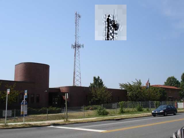
Whether the plane flew just over this spindly 'obstacle' or nicked its top, the descent issues are roughly the same - a descent from 305ft MSL to about 35-40, a total non-linear descent of 270 feet over a span of about 3400 feet. This means a descent of 165 feet from FDR last frame before the antenna and another app. 235 feet dropped from the antenna to the first light pole in the same rough distance but at higher speed. I'm no pilot, but a lower altitude at the tower makes a bit more sense.
For a different aspect on aircraft height, Terry Morin at the Navy Annex (aka FOB) placed the Boeing “essentially right over the top of me and the outer portion of the FOB (flight path parallel the outer edge of the FOB). Everything was shaking and vibrating, including the ground. I estimate that the aircraft was no more than 100 feet above me (30 to 50 feet above the FOB) in a slight nose down attitude.” For this I’ll us a graphic I used earlier when CIT argued a similar problem relating to descent angles and impossible stuff, just updated a bit. It’s a panoramic graphic so here’s the right half with a reasonable descent angle to the light poles and impact.
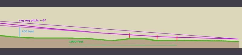
And here is the important half, with the tower added to scale and cross-sectional placement. Oddly, my previous lines extended back take it over the tower neatly, but that’s a pretty steep descent. It looks like it would cause 3.5-11.2 Gs, considering the range offered so far. If we take Morin’s account as closer, which I tend to, it had to be much lower, which offers a more reasonable pitch, but takes the plane well below the top of the tower. This means an impact if Merc’s government line is accurate.
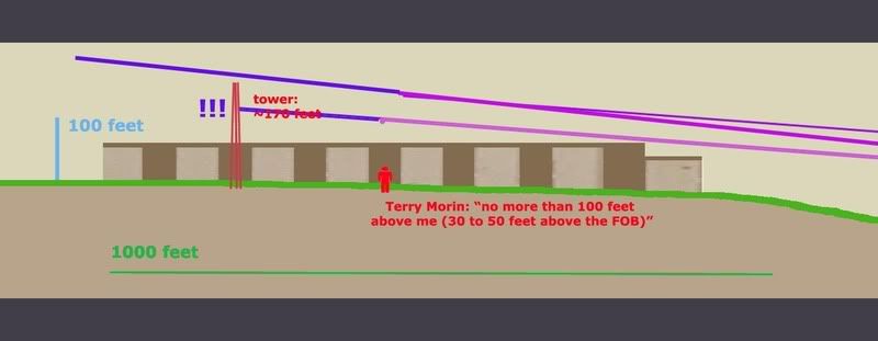
But I doubt it is. Flight paths aren't perfectly straight. They wiggle a bit, especially I would think at high speeds in the lower atmosphere. In another post I established that the witness record and physical damage best fits with a moderate left bank over the Navy annex, and likely a slight left curve to the flight path between the Navy Annex and Route 27 where it leveled slightly, with an apparent left bank of about –5-6° evident in the impact damage.
So considering all we know here is a proposal I offer: I had first favored the purple swerve, but after reviewing Morin I'm betting on the green line at the moment, or else the purple one.
- Final trajectory by pole and building damage - ≈ 61°
- Final FDR heading ≈ 59.9° (these are shown in red at the corners).
- The big yellow dot at lower left is the last reported position in the FDR data we have
- The yellow line a straight shot from there to the damage path. This indeed crosses over or within a few feet of the tower, probably too close for comfort if it weren’t high enough.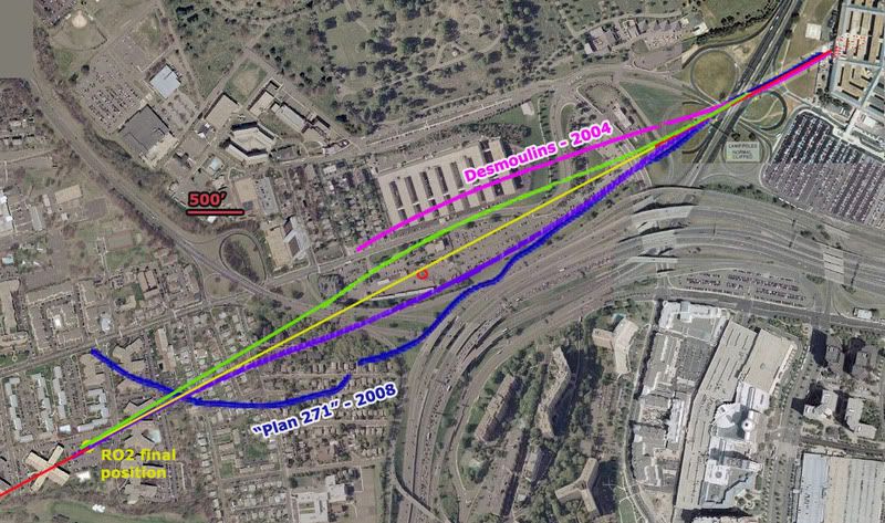
Before going graphically away from straight lines, I added for comparison two non-straight attempts to explain the ‘official’ evidence. In magenta a 2004 estimate by Jean-Pierre Desmoulins with a notable wiggle to it. He’s a pilot. Also in dark blue is an estimate by “Plan 271,” based on eyewitness reports from Dawn Vignola.
The two variations I’ve traced in green and purple are the most moderate explanations. While the green path fits best with Morin's account, the purple one is perhaps more consistent with left bank clues. Note the scale here – 500 feet is just a short line - and that each path is traced along the fuselage centerline. To clear the tower north or south it need only pass 62 feet away (124-foot wingspan). On closer inspection they pass about 250 feet from the tower, so I could’ve made them much milder. In fact I'm thinking the best fit is about 1/3 from the yellow line to the green one, with perhaps a left turn starting earlier, just after the tower, giving it a noticeable left tilt as it approached Route 27.
But even this extreme, both visibly look possible and reasonable – connecting two nearly identical trajectories with a gentle curve away and back, and still safely north or south of the tower. Altitude options open up. Either way, it looks like a reasonable avoidance procedure of a minor object on the attack path. if it were that low, which the witnesses and FDR seem to indicate.
Purple swerve - Max angle required to avoid the tower ≈ 68°
Min angle required to avoid the tower ≈ 53°
Green swerve - about the same
Time frame: app 6-7 seconds from the yellow dot
Any pilots? How impossible is that?
This is a non-issue – a needle of an obstacle that would be missed almost by definition if the path were anything other than perfectly straight, which it probably was. It’s also a non-issue because all previous attempts to ‘prove the official story impossible’ have failed under the test of verification. All that’s happening here is the wrong data being looked at the wrong way and attributed back to reality in a repeated straw man maneuver that’s giving many a case of hay fever. There is nothing impossible about what happened, and as a relative non-issue that seems prohibitively tedious to either prove or debunk I’m not even taking this one to the forums.
Update 3/23:
I took it to the forums a little. 9/11 Blogger (comments page 2) - Above Top Secret.com
update 3/19:
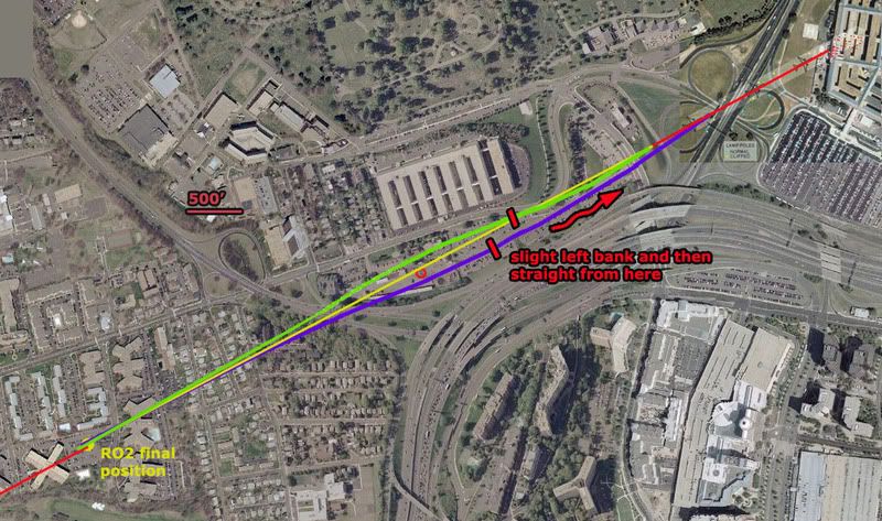
note: in the graphic above I somehow screwed up the 500' scale, making it actually represent about 400 feet. Luckily my margin was still wide enough that these mild swerves are still a fit, both passing well over 100 feet from the antenna tower.
update 3/21:
I just located again Russell Pickering's take on Paik's antenna memories from the old old LCF, 9/10/06:
"I went to the VDOT to confirm it hadn't been hit. It had not. Then in Edward's interview I asked him if he actually saw it hit the tower and he said no. Then I asked him if it hit the solid metal part of the tower and he said no. What he said was that it hit a smaller antenna of 2-3 meters in length on the top. He ended up telling us the reason he thought it had been hit was because he saw somebody up on the tower working the next day.
What had happened then is he incorporated a conclusion from something he saw later into his memory of the original account. The real story is that when the FBI took over the VDOT as a command post they added antennas to the tower for communication." [emph. mine]
So it actually was not a coincidence people were up there the day after a plane flew by there. There was a direct cause and effect relationship between the two, as that plane had turned the area into a major hurking crime scene of the utmost national security importance. They needed many things, including communications. And perhaps the old antenna was also coincidentally damaged by the plane and replaced at the same time. That certainly can't be ruled out and in fact may well be the case judging by the new evidence coming to light. And that would certainly be another problem for the north path fly over story.
Update 3/23: CIT's take was not coincidence of antenna work but rather that it was not damage-related. They seem the feel it was the military, not the FBI, who put up the new antenna. And we have further confirmation that it was not damaged: John Farmer has confirmed the fact again with the VDOT smart center manager. He offered no details beyond "that was not true!," but as Farmer noted "if anyone should know it would be him (he would have to approve the replacement cost since he was the manager)." [e-mail]
WHY THIS ANTENNA THING IS A NON-ISSUE
Adam Larson / Caustic Logic
The Frustrating Fraud
March 18 2008
last update 3/23 3am
Okay, so here’s my response to Rob Balsamo’s new masterpiece Arlington Topography, Obstacles Make American 77 Final Leg Impossible. Yet again, we hear, some things taken together with other things have again proven the official story of the Pentagon attack is physically impossible. He dated the piece March 13 so he could say dramatically “"Beware The Ides Of March" could not be a more appropriate introduction to this article as it appears the government story regarding the events at the pentagon is officially dead.” Again the merry-go-round spins and in the end… again…. everyone disagrees still. I weary of this game, and this latest seems really a pathetic attempt. But it is in my area and people have asked my opinion, so I guess I need to cover it.
After infinite CIT re-posts of Pilots for Truth misfindings, it seems it was Rob Balsamo’s turn to catch them back. “Thanks to the hard work done by Citizen Investigation Team, they alerted us to review figures regarding topography and obstacles along the flight path of American 77 according to the government story. […] According to the government, American 77 final approach to the pentagon is depicted below.”
This graphic is not produced by the government, but by Merc Mercy CIT. I’m sure it’s fairly close to accurate, but is it close enough to say where the plane was relative to this 5-foot wide ‘obstacle?’ I’d have to say no. But Balsamo acts as if the government had drawn the line that took the plane right into or over this VDOT transmitter tower, 169 ft tall (including 6-foot antennas on top) above a ground elevation of 135 feet. He never explains whether or not this tower WAS hit, just takes a point right above it as a starting point. From this he did a bunch of math, with too many steps it seems to me, and decided that such a descent from above the tower to the light poles and into the building level would require 11.2 Gs of force.
“Conclusion = Impossible for any transport category aircraft to descend from top of VDOT Antenna to top of pole 1 and pull level to "impact hole" as reported by the government story and seen in the DoD "5 Frames Video". 11.2 G's was never recorded in the FDR. 11.2 G's would rip the aircraft apart.”
I don’t intend to get into the math of all this, but John Farmer’s response is worthy of note: Mission impossible He found that Balsamo’s numbers didn’t add up to what he said they did, double-checked and found the g-force would be 3.5, not 11.2. “So “impossible” is not the word I would use Rob.”
Then he also passed on the video interview of witness Ed Paik explaining how the antenna on top was indeed damaged. Somehow this was not included in Balsamo’s post even though his sources were there when Paik said this. Ranke had to add after that indeed Paik said this but, as Ranke explained back in 2006 “he just deduced this because he saw them working on it the next day. We confirmed with the VDOT employees that the antenna was not clipped.”
This maintenance was routine then, and just happened to occur one day after the plane flew right over it. Says CIT. Perhaps… But doubts remain; the only photo anyone’s yet found that shows the tower on 9/11 after the strike, by Steve Riskus, shows some hints of a damaged antenna, as Farmer discovered. I can see this, the deformation of the shorter right spire, and it's an intriguing possibility; as Arabesque puts it: ""We have a plane that many witnessed flying by the area the previous day. We have the flight data recorder suggesting that the plane might very well have been in line to hit the top of the tower and continue its trajectory; impacting the light poles and the Pentagon. We have a witness who confirms that the plane was flying at the approximate height of this tower and that he suspected that it was damaged from an impact with the plane as it was being repaired the next day--the two meter antenna replaced by a repair-man. If it can be proven that the tower was damaged from the incoming plane, this would be another compelling piece of evidence for the south of CITGO gas station approach and impact into the Pentagon; corroborated by the flight data recorder no less.""[e-mail]
However, this photo is just not clear enough for me. It’s essentially a needle in the distance, lost in a digital haystack. Any slight artifact will warp it too easily. In fact when people were TRYING to take a good picture in 2006, it almost looks like one antenna is missing entirely (below). I don’t think we’ll ever see a picture clear enough to say unless it was taken by the repairman, but I'd need to see better evidence it was NOT damaged before I'd believe that either (a copy of the work order for 9/12 stating the reason for the repair, for example). I’m leaving this aspect ambiguously undecided and moving on.
Whether the plane flew just over this spindly 'obstacle' or nicked its top, the descent issues are roughly the same - a descent from 305ft MSL to about 35-40, a total non-linear descent of 270 feet over a span of about 3400 feet. This means a descent of 165 feet from FDR last frame before the antenna and another app. 235 feet dropped from the antenna to the first light pole in the same rough distance but at higher speed. I'm no pilot, but a lower altitude at the tower makes a bit more sense.
For a different aspect on aircraft height, Terry Morin at the Navy Annex (aka FOB) placed the Boeing “essentially right over the top of me and the outer portion of the FOB (flight path parallel the outer edge of the FOB). Everything was shaking and vibrating, including the ground. I estimate that the aircraft was no more than 100 feet above me (30 to 50 feet above the FOB) in a slight nose down attitude.” For this I’ll us a graphic I used earlier when CIT argued a similar problem relating to descent angles and impossible stuff, just updated a bit. It’s a panoramic graphic so here’s the right half with a reasonable descent angle to the light poles and impact.
And here is the important half, with the tower added to scale and cross-sectional placement. Oddly, my previous lines extended back take it over the tower neatly, but that’s a pretty steep descent. It looks like it would cause 3.5-11.2 Gs, considering the range offered so far. If we take Morin’s account as closer, which I tend to, it had to be much lower, which offers a more reasonable pitch, but takes the plane well below the top of the tower. This means an impact if Merc’s government line is accurate.
But I doubt it is. Flight paths aren't perfectly straight. They wiggle a bit, especially I would think at high speeds in the lower atmosphere. In another post I established that the witness record and physical damage best fits with a moderate left bank over the Navy annex, and likely a slight left curve to the flight path between the Navy Annex and Route 27 where it leveled slightly, with an apparent left bank of about –5-6° evident in the impact damage.
So considering all we know here is a proposal I offer: I had first favored the purple swerve, but after reviewing Morin I'm betting on the green line at the moment, or else the purple one.
- Final trajectory by pole and building damage - ≈ 61°
- Final FDR heading ≈ 59.9° (these are shown in red at the corners).
- The big yellow dot at lower left is the last reported position in the FDR data we have
- The yellow line a straight shot from there to the damage path. This indeed crosses over or within a few feet of the tower, probably too close for comfort if it weren’t high enough.
Before going graphically away from straight lines, I added for comparison two non-straight attempts to explain the ‘official’ evidence. In magenta a 2004 estimate by Jean-Pierre Desmoulins with a notable wiggle to it. He’s a pilot. Also in dark blue is an estimate by “Plan 271,” based on eyewitness reports from Dawn Vignola.
The two variations I’ve traced in green and purple are the most moderate explanations. While the green path fits best with Morin's account, the purple one is perhaps more consistent with left bank clues. Note the scale here – 500 feet is just a short line - and that each path is traced along the fuselage centerline. To clear the tower north or south it need only pass 62 feet away (124-foot wingspan). On closer inspection they pass about 250 feet from the tower, so I could’ve made them much milder. In fact I'm thinking the best fit is about 1/3 from the yellow line to the green one, with perhaps a left turn starting earlier, just after the tower, giving it a noticeable left tilt as it approached Route 27.
But even this extreme, both visibly look possible and reasonable – connecting two nearly identical trajectories with a gentle curve away and back, and still safely north or south of the tower. Altitude options open up. Either way, it looks like a reasonable avoidance procedure of a minor object on the attack path. if it were that low, which the witnesses and FDR seem to indicate.
Purple swerve - Max angle required to avoid the tower ≈ 68°
Min angle required to avoid the tower ≈ 53°
Green swerve - about the same
Time frame: app 6-7 seconds from the yellow dot
Any pilots? How impossible is that?
This is a non-issue – a needle of an obstacle that would be missed almost by definition if the path were anything other than perfectly straight, which it probably was. It’s also a non-issue because all previous attempts to ‘prove the official story impossible’ have failed under the test of verification. All that’s happening here is the wrong data being looked at the wrong way and attributed back to reality in a repeated straw man maneuver that’s giving many a case of hay fever. There is nothing impossible about what happened, and as a relative non-issue that seems prohibitively tedious to either prove or debunk I’m not even taking this one to the forums.
Update 3/23:
I took it to the forums a little. 9/11 Blogger (comments page 2) - Above Top Secret.com
update 3/19:
note: in the graphic above I somehow screwed up the 500' scale, making it actually represent about 400 feet. Luckily my margin was still wide enough that these mild swerves are still a fit, both passing well over 100 feet from the antenna tower.
update 3/21:
I just located again Russell Pickering's take on Paik's antenna memories from the old old LCF, 9/10/06:
"I went to the VDOT to confirm it hadn't been hit. It had not. Then in Edward's interview I asked him if he actually saw it hit the tower and he said no. Then I asked him if it hit the solid metal part of the tower and he said no. What he said was that it hit a smaller antenna of 2-3 meters in length on the top. He ended up telling us the reason he thought it had been hit was because he saw somebody up on the tower working the next day.
What had happened then is he incorporated a conclusion from something he saw later into his memory of the original account. The real story is that when the FBI took over the VDOT as a command post they added antennas to the tower for communication." [emph. mine]
So it actually was not a coincidence people were up there the day after a plane flew by there. There was a direct cause and effect relationship between the two, as that plane had turned the area into a major hurking crime scene of the utmost national security importance. They needed many things, including communications. And perhaps the old antenna was also coincidentally damaged by the plane and replaced at the same time. That certainly can't be ruled out and in fact may well be the case judging by the new evidence coming to light. And that would certainly be another problem for the north path fly over story.
Update 3/23: CIT's take was not coincidence of antenna work but rather that it was not damage-related. They seem the feel it was the military, not the FBI, who put up the new antenna. And we have further confirmation that it was not damaged: John Farmer has confirmed the fact again with the VDOT smart center manager. He offered no details beyond "that was not true!," but as Farmer noted "if anyone should know it would be him (he would have to approve the replacement cost since he was the manager)." [e-mail]
Saturday, September 15, 2007
REBUTTAL TO JAMES FETZER
LITMUS TEST FOR RATIONAILTY?
REBUTTAL TO JAMES FETZER
Adam Larson / Caustic Logic
The Frustrating Fraud
June 27 2007
last updated September 15 2007
A new press release boosting Pilots for 9/11 Truth as “driv[ing] another nail into a coffin of lies told the American people by The 9/11 Commission” was just released by Scholars for 9/11 Truth (the Fetzer wing). Co-founder of the recently-divided organization James Fetzer in fact seems to have written up the release, titled “New study from Pilots for 9/11 Truth: No Boeing 757 hit the Pentagon.” It was released on June 21 and picked up by Yahoo news, apparently a bit of an achievement, and has been widely republished since then. It demands a firm, well thought out response from my end, and hence the slight delay in publishing this (and the later edits and updates).
As the public decree explains, the Pilots had petitioned the National Transportation Safety Board (NTSB) under the Freedom of Information Act to receive data from the Black Box (FDR) of Flight 77. Their study of the data, Fetzer announced, “has confirmed the previous findings of Scholars for 9/11 Truth that no Boeing 757 hit the Pentagon on 9/11.” [1] I'm not sure "report" is quite the right word; it's "signed by fifteen professional pilots," so it seems to be their three-month-old March 26 Press Release, which summarized all their AA77 FDR findings. Fetzer sums their points: “the plane was too high to hit lamp posts and would have flown over the Pentagon, not impacted with its ground floor.” So it's not terribly “new,” and what’s even older is the tired list of hollow no-planer reasoning that is his group’s bolstered previous argument.
"We have had four lines of proof that no Boeing 757 hit the building,” he explained, all flawed, well-explained or seriously questioned elsewhere, and too boring to bother re-hashing in detail here; but briefly, 1) the too small hole and “the wrong […] kind and quantity of debris,” 2) the CCTV video that shows something smaller than a 757 he thinks, 3) ground effect, and 4) the unmarked lawn. These four tracks of reasoning prove to Fetzer, “conclusively, in my judgment - that no Boeing 757 hit the building.” Noting the eyewitness accounts of an AA 757 that flew by that way as the “most important evidence to the contrary,” he found that “if the NTSB data is correct, then the Pilot's study shows that a large aircraft headed toward the building but did not impact with it. It swerved off and flew above the Pentagon." [2] Just like others have been theorizing lately. How nicely it all falls together… and the Pilots don’t even have to offer a theory themselves.
Anyway…he wrote the piece with the cooperation of Rob Balsamo (John Doe X, co-founder of Pilots for 911 Truth), who explained elsewhere “Jim Fetzer and myself worked on this together.” Yet the final PR contained a major blunder… Fetzer stated that the Pilots “not only obtained the flight data but created a computer animation to demonstrate what it told them.” [3] What on Earth does that mean? I haven't seen this other animation yet, and had just been in a wrangle with Balsamo for hinting at just that possibility, contrary to their claims. Balsamo had to scramble to clarify their group “did not create the animation, which we included in "Pandora's Back Box". The NTSB provided the animation based upon its own data and spread spread sheets which can be found at our site/forums.” [4]
--
update 8/11: Recently Pilots for Truth did release an animation based on the black box data. It's pretty interesting and well done. Viewable here. Perhaps this is what Fetzer was talking about?
update 9/15: As Rob has pointed out to me, the crossed-out statement above is wrong - based on a misreading. Aplogies to have miseld with this sloppiness. They worked together on the corrections, as is obvious when I look back. In pennance, a gratis link to his unfiltered words.
--
Otherwise Fetzer carefully quotes Balasamo’s vague copy-and-paste master take on their findings: "the information in the NSTB documents does not support, and in some instances factually contradicts, the official government position that American Airlines Flight 77 struck the Pentagon on the morning of September 11, 2001." While it’s more tame than what Fetzer says, he’s not so much putting words in Balsamo’s mouth as – well, here’s another careful quote:
“Pilotsfor911truth.org does not make the claim that "No Boeing 757 hit the Pentagon". We have analyzed the Flight Data Recorder data provided by the NTSB and have shown factual analysis of that data. We do not offer theory.
While we do not make this claim in these words, the analysis we present on the basis of the NTSB's own data factually contradicts the official account that Flight 77 hit the Pentagon--if trends are continued beyond end of data records--and therefore supports the inference that American Airlines Flight 77 did not hit the building based upon that data.” [5]
In other words, they have only discovered and relayed factual government data that supports the inference that the plane would not have hit. They didn’t say it didn’t hit. They let Fetzer say it for them.
“Don't be taken in by photos showing damage to the second floor or those taken after the upper floors collapsed, which happened 20-30 minutes later," Fetzer warned, and by which I’m not sure what he means. "In fact, debris begins to show up on the completely clean lawn in short order,” and proposed this fake plane debris “might have been dropped from a C-130 that was circling above the Pentagon or placed there by men in suits who were photographed carrying debris with them." [6] Might be…
The most famous such scrap, photographed by Mark Faram, Fetzer admits “is a piece from the fuselage of a commercial airliner, which is frequently adduced as evidence,” by, for example, James Hanson of Ohio. Fetzer explains in his PR that Hanson “has traced that debris to an American Airlines 757 that crashed in a rain forest above Cali, Columbia in 1995.” Check out what this genius Hanson uses for evidence: a six-year old liana vine still embedded in the Pentagon "fuselage" metal! You have to see it to disbelieve it, so DO NOT click that link if you want to believe Hanson. Fetzer bought it though and was impressed enough with this find to offer to republish Hanson’s study on the Scholars’ site. [7]
One of the deepest ironies revealed in Fetzer’s missive is that "Fetzer [...] retired last June after 35 years of teaching courses in logic, critical thinking, and scientific reasoning.” Well, how could one argue with the logical conclusions of a renowned logic expert? I’ll try it caustically. Fact is, what this background of his shows to me is that he knows exactly what he’s doing – elevating a fraud to guiding principle of the “Truth Movement” he claims a leadership role in to arrive at the “truth.” In the end, from all this Fetzer was able to use his deep knowledge of ctical thinking and scientific deduction (as well, of course, as years learning all of their opposites – the arts of sophistry, quackery, and deception) to deduce an argument finally totally inverse to my own growing suspicions:
"The Pentagon has become a kind of litmus test for rationality in the study of 9/11. Those who persist in maintaining that a Boeing 757 hit the building are either unfamiliar with the evidence or cognitively impaired. Unless they want to mislead the American people. The evidence is beyond clear and compelling. It places this issue 'beyond a reasonable doubt'. No Boeing 757 hit the Pentagon."
I am quite familiar with the evidence, and I invite anyone to check my reasoning for soundness of judgment. That’s what this site’s about: “the hijacking of the 9/11 Truth Movement by the no-757 at the Pentagon theory." It almost feels with this salvo like Fetzer the mental “muscle hijacker” is letting us know the pilots have the cockpit; he tells us never mind the doubters, move to the back of the plane. No need to investigate for yourselves, we have it all figured out. We are returning to the airport. We just need to agree on this and move on.
But what if the Pilots intend to crash this plane? It’s happened before. That's not even a box cutter Fetzer's holding, people. It's a carbdoard prop. We can take this plane back. Let's Roll.
Sources:
[1], [2], [3], [6], [7] Fetzer, James/Scholars for 9/11 Truth. “New study from Pilots for 9/11 Truth: No Boeing 757 hit the Pentagon.” June 21 2007.
Trackback URL: http://prweb.com/pingpr.php/Q291cC1NYWduLVRoaXItQ291cC1UaGlyLVplcm8=
http://news.yahoo.com/s/prweb/20070621/bs_prweb/prweb534642_1
[4], [5] John Doe X. Official Comment/corrections. Pilots for 9/11 Truth Discussion Board. Posted Jun 23 2007, 12:36 AM. http://z9.invisionfree.com/Pilots_For_Truth/index.php?s=ec3b737719855ae19fc27c1b5a81c7b0&showtopic=7372&st=15&#entry9361808
REBUTTAL TO JAMES FETZER
Adam Larson / Caustic Logic
The Frustrating Fraud
June 27 2007
last updated September 15 2007
A new press release boosting Pilots for 9/11 Truth as “driv[ing] another nail into a coffin of lies told the American people by The 9/11 Commission” was just released by Scholars for 9/11 Truth (the Fetzer wing). Co-founder of the recently-divided organization James Fetzer in fact seems to have written up the release, titled “New study from Pilots for 9/11 Truth: No Boeing 757 hit the Pentagon.” It was released on June 21 and picked up by Yahoo news, apparently a bit of an achievement, and has been widely republished since then. It demands a firm, well thought out response from my end, and hence the slight delay in publishing this (and the later edits and updates).
As the public decree explains, the Pilots had petitioned the National Transportation Safety Board (NTSB) under the Freedom of Information Act to receive data from the Black Box (FDR) of Flight 77. Their study of the data, Fetzer announced, “has confirmed the previous findings of Scholars for 9/11 Truth that no Boeing 757 hit the Pentagon on 9/11.” [1] I'm not sure "report" is quite the right word; it's "signed by fifteen professional pilots," so it seems to be their three-month-old March 26 Press Release, which summarized all their AA77 FDR findings. Fetzer sums their points: “the plane was too high to hit lamp posts and would have flown over the Pentagon, not impacted with its ground floor.” So it's not terribly “new,” and what’s even older is the tired list of hollow no-planer reasoning that is his group’s bolstered previous argument.
"We have had four lines of proof that no Boeing 757 hit the building,” he explained, all flawed, well-explained or seriously questioned elsewhere, and too boring to bother re-hashing in detail here; but briefly, 1) the too small hole and “the wrong […] kind and quantity of debris,” 2) the CCTV video that shows something smaller than a 757 he thinks, 3) ground effect, and 4) the unmarked lawn. These four tracks of reasoning prove to Fetzer, “conclusively, in my judgment - that no Boeing 757 hit the building.” Noting the eyewitness accounts of an AA 757 that flew by that way as the “most important evidence to the contrary,” he found that “if the NTSB data is correct, then the Pilot's study shows that a large aircraft headed toward the building but did not impact with it. It swerved off and flew above the Pentagon." [2] Just like others have been theorizing lately. How nicely it all falls together… and the Pilots don’t even have to offer a theory themselves.
Anyway…
--
update 8/11: Recently Pilots for Truth did release an animation based on the black box data. It's pretty interesting and well done. Viewable here. Perhaps this is what Fetzer was talking about?
update 9/15: As Rob has pointed out to me, the crossed-out statement above is wrong - based on a misreading. Aplogies to have miseld with this sloppiness. They worked together on the corrections, as is obvious when I look back. In pennance, a gratis link to his unfiltered words.
--
Otherwise Fetzer carefully quotes Balasamo’s vague copy-and-paste master take on their findings: "the information in the NSTB documents does not support, and in some instances factually contradicts, the official government position that American Airlines Flight 77 struck the Pentagon on the morning of September 11, 2001." While it’s more tame than what Fetzer says, he’s not so much putting words in Balsamo’s mouth as – well, here’s another careful quote:
“Pilotsfor911truth.org does not make the claim that "No Boeing 757 hit the Pentagon". We have analyzed the Flight Data Recorder data provided by the NTSB and have shown factual analysis of that data. We do not offer theory.
While we do not make this claim in these words, the analysis we present on the basis of the NTSB's own data factually contradicts the official account that Flight 77 hit the Pentagon--if trends are continued beyond end of data records--and therefore supports the inference that American Airlines Flight 77 did not hit the building based upon that data.” [5]
In other words, they have only discovered and relayed factual government data that supports the inference that the plane would not have hit. They didn’t say it didn’t hit. They let Fetzer say it for them.
“Don't be taken in by photos showing damage to the second floor or those taken after the upper floors collapsed, which happened 20-30 minutes later," Fetzer warned, and by which I’m not sure what he means. "In fact, debris begins to show up on the completely clean lawn in short order,” and proposed this fake plane debris “might have been dropped from a C-130 that was circling above the Pentagon or placed there by men in suits who were photographed carrying debris with them." [6] Might be…
The most famous such scrap, photographed by Mark Faram, Fetzer admits “is a piece from the fuselage of a commercial airliner, which is frequently adduced as evidence,” by, for example, James Hanson of Ohio. Fetzer explains in his PR that Hanson “has traced that debris to an American Airlines 757 that crashed in a rain forest above Cali, Columbia in 1995.” Check out what this genius Hanson uses for evidence: a six-year old liana vine still embedded in the Pentagon "fuselage" metal! You have to see it to disbelieve it, so DO NOT click that link if you want to believe Hanson. Fetzer bought it though and was impressed enough with this find to offer to republish Hanson’s study on the Scholars’ site. [7]
 |
"The Pentagon has become a kind of litmus test for rationality in the study of 9/11. Those who persist in maintaining that a Boeing 757 hit the building are either unfamiliar with the evidence or cognitively impaired. Unless they want to mislead the American people. The evidence is beyond clear and compelling. It places this issue 'beyond a reasonable doubt'. No Boeing 757 hit the Pentagon."
I am quite familiar with the evidence, and I invite anyone to check my reasoning for soundness of judgment. That’s what this site’s about: “the hijacking of the 9/11 Truth Movement by the no-757 at the Pentagon theory." It almost feels with this salvo like Fetzer the mental “muscle hijacker” is letting us know the pilots have the cockpit; he tells us never mind the doubters, move to the back of the plane. No need to investigate for yourselves, we have it all figured out. We are returning to the airport. We just need to agree on this and move on.
But what if the Pilots intend to crash this plane? It’s happened before. That's not even a box cutter Fetzer's holding, people. It's a carbdoard prop. We can take this plane back. Let's Roll.
Sources:
[1], [2], [3], [6], [7] Fetzer, James/Scholars for 9/11 Truth. “New study from Pilots for 9/11 Truth: No Boeing 757 hit the Pentagon.” June 21 2007.
Trackback URL: http://prweb.com/pingpr.php/Q291cC1NYWduLVRoaXItQ291cC1UaGlyLVplcm8=
http://news.yahoo.com/s/prweb/20070621/bs_prweb/prweb534642_1
[4], [5] John Doe X. Official Comment/corrections. Pilots for 9/11 Truth Discussion Board. Posted Jun 23 2007, 12:36 AM. http://z9.invisionfree.com/Pilots_For_Truth/index.php?s=ec3b737719855ae19fc27c1b5a81c7b0&showtopic=7372&st=15&#entry9361808
Wednesday, August 8, 2007
NTSB ANIMATION INTERNAL GEOGRAPHY, PART 1
NTSB ANIMATION INTERNAL GEOGRAPHY, PART 1
GROUND OBJECTS
Adam Larson / Caustic Logic
The Frustrating Fraud
August 8 2007
last updated 8/17/07
Real-World Lines?
I asked Rob Balsamo/John Doe X, co-founder of Pilots for 9/11 Truth “do the lines on the background map in the animation represent latitude and longitude lines?” I already had a good idea of the "right" answer I was hoping for, which he didn’t supply.
“It sure looks that way when analyzed vs. google earth.”
In a sense, the lines do mimic real-world ones by running north-south and east-west (roughly anyway - I haven’t ruled out a magnetic-as-real north discrepancy yet) and intersect at what seems right angles. Extreme perspective and (in my case) low resolution make these things hard to determine. But below I will show, at the very least, the markers laid down under the runway and final map either represent illogical marking points on real geography or, more likely, have no bearing whatsoever on the plane’s real location or the FDR data.
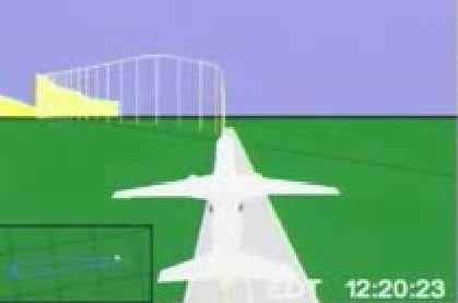
 The first thing I saw that made me scratch my head was the latitude line that intersects the runway at takeoff, as seen above. Runway 30, at the south end of Dulles airport, points slightly north of west, for a compass bearing of 290 degrees real, and about the right angle to intersect a latitude line as seen on the rendered runway. But below is a map I made that shows the nearest major latitude lines: 38 degrees, 57 minutes, zero seconds (38° 57’ 00”) North, which does not intersect even this massively long runway, and 38° 56’ 00”, which runs just south of its base. The intersector could be 38° 57’ 30”, though it seems a bit odd to map this mid-point when the minutes are so close already.
While not conclusive in itself, this linear oddity makes sense in the context of this anonymous comment left at my blog using “we” when referring to the NTSB:
“The ground representation below NTSB animation of Flight 77 is not connected to the aircraft data that makes the plane move. The data from the FDR was used to make the aircraft animation, but there is no actual correlation to the ground. The NTSB animation is only a working copy and we never finished it to be accurate to actual ground objects.”
There was an effort to show ground objects, of course, with the rendered runway and the Pentagon overlay map relative to the pane at start and finish. With only these two points, the grid in between the two, and the plane’s movements to go on, I’m attempting to see how closely the animations global grid compares with real world lines.
 One thing about the grid map we should also see is the longitudinal separations being narrower than latitude. At the equator, the rectangles formed where lines intersect are square (the sides are “equated”). Latitude lines (east-west) remain parallel and equidistant, and are often called “parallels.” But Longitude lines (north-south) run closer together nearer the poles and in fact merge there. The net effect of this is that the parcels become narrower rectangles as we move north or south.
The Grid at the Pentagon
In the upper 38th parallel, the location of the Pentagon, the rectangles formed are at a proportion of about 5:7. In the map below, I also subdivided the latitude measurements showing the halfway markers at 30 seconds (30”). These are the dotted lines, and would probably not be mapped in an animation. The Pentagon lies between 38° 52’ and 38° 52’30” north, and 77°03’ and 77°04’ west, with point of impact at near dead center of that rectangle that would, by definition, be the rough area of the animation overlay map. Note that none of these lines crosses or touches the Pentagon itself.
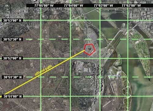
 If the animation’s map were set to real-world lines, its proportions around the Pentagon should look something like the graphic I did at left (dotted lines included for reference). Instead what get is the situation below, a slightly enhanced screen cap with Pentagon circled in red.
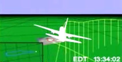
Did the Safety Board's experts shrink and shift the Pentagon here, so rather than dominating a third of the rectangle it’s a speck at its northeast corner? Looking closer at the overlay map, this latitude line actually crosses the northern third of the Pentagon, which is not what the real lines do.
These clearly are not latitude and longitude lines at the minute marks. While too big by far for that, they are far too small of course to be degree markers. Do these represent any real groupings of real-world lines (say every five minutes)? Or is this Perhaps this just some mappish looking grid meaning nothing at all just etched on to show “hey, this is some kinda globe.” Perhaps this is one of the shortcomings of the “working copy” they ironed out later in the process.
Three other questions remain under investigation: the proportions of the rectangles shown, the overall orientation of the grid lines (based on true north or magnetic?), and whether the final map is rotated relative to the program’s internal geography. These will take some more analysis, although in the last case it seems there's clearly some kind of rotation.
GROUND OBJECTS
Adam Larson / Caustic Logic
The Frustrating Fraud
August 8 2007
last updated 8/17/07
Real-World Lines?
I asked Rob Balsamo/John Doe X, co-founder of Pilots for 9/11 Truth “do the lines on the background map in the animation represent latitude and longitude lines?” I already had a good idea of the "right" answer I was hoping for, which he didn’t supply.
“It sure looks that way when analyzed vs. google earth.”
In a sense, the lines do mimic real-world ones by running north-south and east-west (roughly anyway - I haven’t ruled out a magnetic-as-real north discrepancy yet) and intersect at what seems right angles. Extreme perspective and (in my case) low resolution make these things hard to determine. But below I will show, at the very least, the markers laid down under the runway and final map either represent illogical marking points on real geography or, more likely, have no bearing whatsoever on the plane’s real location or the FDR data.
The first thing I saw that made me scratch my head was the latitude line that intersects the runway at takeoff, as seen above. Runway 30, at the south end of Dulles airport, points slightly north of west, for a compass bearing of 290 degrees real, and about the right angle to intersect a latitude line as seen on the rendered runway. But below is a map I made that shows the nearest major latitude lines: 38 degrees, 57 minutes, zero seconds (38° 57’ 00”) North, which does not intersect even this massively long runway, and 38° 56’ 00”, which runs just south of its base. The intersector could be 38° 57’ 30”, though it seems a bit odd to map this mid-point when the minutes are so close already. While not conclusive in itself, this linear oddity makes sense in the context of this anonymous comment left at my blog using “we” when referring to the NTSB:
“The ground representation below NTSB animation of Flight 77 is not connected to the aircraft data that makes the plane move. The data from the FDR was used to make the aircraft animation, but there is no actual correlation to the ground. The NTSB animation is only a working copy and we never finished it to be accurate to actual ground objects.”
There was an effort to show ground objects, of course, with the rendered runway and the Pentagon overlay map relative to the pane at start and finish. With only these two points, the grid in between the two, and the plane’s movements to go on, I’m attempting to see how closely the animations global grid compares with real world lines.
One thing about the grid map we should also see is the longitudinal separations being narrower than latitude. At the equator, the rectangles formed where lines intersect are square (the sides are “equated”). Latitude lines (east-west) remain parallel and equidistant, and are often called “parallels.” But Longitude lines (north-south) run closer together nearer the poles and in fact merge there. The net effect of this is that the parcels become narrower rectangles as we move north or south. The Grid at the Pentagon
In the upper 38th parallel, the location of the Pentagon, the rectangles formed are at a proportion of about 5:7. In the map below, I also subdivided the latitude measurements showing the halfway markers at 30 seconds (30”). These are the dotted lines, and would probably not be mapped in an animation. The Pentagon lies between 38° 52’ and 38° 52’30” north, and 77°03’ and 77°04’ west, with point of impact at near dead center of that rectangle that would, by definition, be the rough area of the animation overlay map. Note that none of these lines crosses or touches the Pentagon itself.
If the animation’s map were set to real-world lines, its proportions around the Pentagon should look something like the graphic I did at left (dotted lines included for reference). Instead what get is the situation below, a slightly enhanced screen cap with Pentagon circled in red. Did the Safety Board's experts shrink and shift the Pentagon here, so rather than dominating a third of the rectangle it’s a speck at its northeast corner? Looking closer at the overlay map, this latitude line actually crosses the northern third of the Pentagon, which is not what the real lines do.
These clearly are not latitude and longitude lines at the minute marks. While too big by far for that, they are far too small of course to be degree markers. Do these represent any real groupings of real-world lines (say every five minutes)? Or is this Perhaps this just some mappish looking grid meaning nothing at all just etched on to show “hey, this is some kinda globe.” Perhaps this is one of the shortcomings of the “working copy” they ironed out later in the process.
Three other questions remain under investigation: the proportions of the rectangles shown, the overall orientation of the grid lines (based on true north or magnetic?), and whether the final map is rotated relative to the program’s internal geography. These will take some more analysis, although in the last case it seems there's clearly some kind of rotation.
Thursday, June 21, 2007
NTSB FOIA RESPONSE LETTER RECEIVED
NTSB FOIA RESPONSE LETTER RECEIVED
NO DISCS ENCLOSED!
Adam Larson/Caustic Logic
The Frustrating Fraud
June 21 2007
Updated 6/26
[Note: This investigation is done under terms of the Freedom of Information Act, requesting documents from the National Transportation Safety Board (NTSB). I was spurrred to it by my suspicions over previous FOIA-obtained NTSB data published by Pilots for 911 Truth. ]
Before I even went the normal FOIA route, I first tried a different strategy, contacting the Public Affairs Department. This effort proved interesting but came to naught. I will write a post about that soon. I followed this up with a Freedom of Information Act request via the online form at the NTSB site:
I am lodging a request for items regarding aircraft no. N644AA American Airlines Flight 77 that crashed on September 11 2001. Items I would like to have sent to me:
1) any and all animations/reconstructions of the FDR data from Flight 77
- a working copy that others have received, including a erroneously-labeled time stamp. (this is available online for visual reference)
- If possible any other animations, like the one presented by the 9/11 Commission in a mid-2004 presentation, aired on C-Span, but for which I can find no information. If this was NTSB-produced and is releasable it would be very useful.
2) electronic attachments listed for the Specialist's Factual report (doc ID DCA01MAO64)
- DCA01MAO64_tabular.csv
- D226A101-3G.pdf
- 757-3b_1.txt
3) Other files:
- AAL77_tabular.csv (if different from CSV listed above)
- Original L3 compressed raw AA77 FDR file
I had despaired on reading "turnaround could range from 3 weeks to 1 year or more," as I filed my request on June 7. The response is dated June 12. It was put in my mailbox on the 15th or 16th while I was out of town and I found it on Sunday the 17th. This swift response paralled two other members at Above Top Secret.com, as well as John Farmer’s receipt at around the same time. Here is the letter I recieved [ny name is redacted here even though it’s on the article header on the off-chance this jpeg gets re-posted all over – my street address is also not something everyone needs to know].
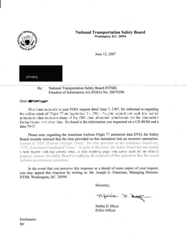
It looks like pretty much the same thing everyone else has been getting, as Rob Balsamo (John Doe X) said I'd get if I asked. The same officer that signed Undertow’s and Snowygrouch’s letters, Melba D. Moye, the same wording, the more recent apology for the wrong time stamp, etc. Sound like the one I’m looking for. It informed me of my recent query, and stated “enclosed is the information you requested on a CD-ROM and a data DVD.” At the bottom are the words “enclosures: tpc,” whatever exactly that means.
So what's on the discs? I don't know. They weren't enclosed. The letter was folded in thirds, placed in a letter-size 8.5x3.75" envelope with nothing else. The envelope was not moisture sealed but secured with clear tape. My address was handwritten, and it had a proper looking address with the warning “official business penalty for private use $300.00” and a handwritten code C10-40 (FOIA).
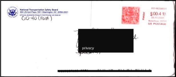 I guessed maybe "enclosed" means in the mail, and started presuming I'd soon have my own copy of the green and purple cartoon with the wrong altitude, wrong lat/long plot, and wrong final bearing that Pilots for 911 Truth and others have been wondering over. But now it seems it’ll be slow in coming, and I’ll have to write in to get this figured out; “In the even that you perceive this response as a denial of some aspect of your request, you may appeal this response by writing” to the NTSB’s managing director Joseph Osterman. They’re all gonna know me real well down there before all this is done.
So while the animation’s direct link to the NTSB remains to be totally verified on my end, the letter sure looks like part of the overall pattern reported so far by FOIA recipients, and it appears I was probably in error for doubting the animation's NTSB pedigree. But strangely, I've been singled out for this silent treatment, some set of factors witholding total confirmation...
NO DISCS ENCLOSED!
Adam Larson/Caustic Logic
The Frustrating Fraud
June 21 2007
Updated 6/26
[Note: This investigation is done under terms of the Freedom of Information Act, requesting documents from the National Transportation Safety Board (NTSB). I was spurrred to it by my suspicions over previous FOIA-obtained NTSB data published by Pilots for 911 Truth. ]
Before I even went the normal FOIA route, I first tried a different strategy, contacting the Public Affairs Department. This effort proved interesting but came to naught. I will write a post about that soon. I followed this up with a Freedom of Information Act request via the online form at the NTSB site:
I am lodging a request for items regarding aircraft no. N644AA American Airlines Flight 77 that crashed on September 11 2001. Items I would like to have sent to me:
1) any and all animations/reconstructions of the FDR data from Flight 77
- a working copy that others have received, including a erroneously-labeled time stamp. (this is available online for visual reference)
- If possible any other animations, like the one presented by the 9/11 Commission in a mid-2004 presentation, aired on C-Span, but for which I can find no information. If this was NTSB-produced and is releasable it would be very useful.
2) electronic attachments listed for the Specialist's Factual report (doc ID DCA01MAO64)
- DCA01MAO64_tabular.csv
- D226A101-3G.pdf
- 757-3b_1.txt
3) Other files:
- AAL77_tabular.csv (if different from CSV listed above)
- Original L3 compressed raw AA77 FDR file
I had despaired on reading "turnaround could range from 3 weeks to 1 year or more," as I filed my request on June 7. The response is dated June 12. It was put in my mailbox on the 15th or 16th while I was out of town and I found it on Sunday the 17th. This swift response paralled two other members at Above Top Secret.com, as well as John Farmer’s receipt at around the same time. Here is the letter I recieved [ny name is redacted here even though it’s on the article header on the off-chance this jpeg gets re-posted all over – my street address is also not something everyone needs to know].
It looks like pretty much the same thing everyone else has been getting, as Rob Balsamo (John Doe X) said I'd get if I asked. The same officer that signed Undertow’s and Snowygrouch’s letters, Melba D. Moye, the same wording, the more recent apology for the wrong time stamp, etc. Sound like the one I’m looking for. It informed me of my recent query, and stated “enclosed is the information you requested on a CD-ROM and a data DVD.” At the bottom are the words “enclosures: tpc,” whatever exactly that means.
So what's on the discs? I don't know. They weren't enclosed. The letter was folded in thirds, placed in a letter-size 8.5x3.75" envelope with nothing else. The envelope was not moisture sealed but secured with clear tape. My address was handwritten, and it had a proper looking address with the warning “official business penalty for private use $300.00” and a handwritten code C10-40 (FOIA).
I guessed maybe "enclosed" means in the mail, and started presuming I'd soon have my own copy of the green and purple cartoon with the wrong altitude, wrong lat/long plot, and wrong final bearing that Pilots for 911 Truth and others have been wondering over. But now it seems it’ll be slow in coming, and I’ll have to write in to get this figured out; “In the even that you perceive this response as a denial of some aspect of your request, you may appeal this response by writing” to the NTSB’s managing director Joseph Osterman. They’re all gonna know me real well down there before all this is done. So while the animation’s direct link to the NTSB remains to be totally verified on my end, the letter sure looks like part of the overall pattern reported so far by FOIA recipients, and it appears I was probably in error for doubting the animation's NTSB pedigree. But strangely, I've been singled out for this silent treatment, some set of factors witholding total confirmation...
Monday, June 4, 2007
NEWS COMING
June 4 2007
I haven't been able to post anything new, update my old posts, or respond to new comments lately, as I've just stumbled into a major hullaballoo about the supposed NTSB flight path animation for Flight 77. In the post TEN DEGREES FROM TRUE: THE "NTSB ANIMATION" IS FLAT WRONG, first done at Above top secret.com the same night (May 27) I outlined my case as to why the animation discrepancy Pilots for 9/11 Truth had used for their video Pandora's Black Box actually worked against the Pilots. This is becuase it is internally inconsistent, showing both a 90 and a 70 degree heading at the same time, and because of it's unclear paper trail and NTSB pedigree.
Frequent references to a "new" animation that popped up during the thread turned out to be another copy of the same animation also said to be from the NTSB. This DVD was recieved May 24 and posted online May 26. Also The Pilots had just re-obtained it themselves, all the same problems and all, this time with a better cover letter and stronger NTSB linkage. The shadow possibility that this blatantly wrong animation is indeed from the officials on high is now directly the possibility I'm looking at, with all that implies or doesn't.
I had no idea all this was happening as I started that thread based on what I knew - oops - and now I'm feeling a bit overwhelmed, as Pilots founder John Doe X is calling me and my cohorts out for not knowing our stuff, and challenging us to contact the NTSB ourselves. But it's too late to turn back now, and the next step is indeed to get some information from the NTSB myself.
So nothing new right now, but this week I'll have something to report.
Tuesday, April 10, 2007
PILOT X AND THE 440 FOOT GAP
FLIGHT 77 ALTITUDE QUESTIONS
Adam Larson
Caustic Logic / The Frustrating Fraud
April 9 2007
last edited 4/15 @ 9:32 pm
In mid-2006, new doubts about the five-year-old Pentagon attack were found, built right into a government-produced animated flight path of AA Flight 77. The group Pilots For 9/11 Truth (P49T) have been able to capitalize on the inherent contradictions in this CG cartoon - most notably in their January 2007 video Pandora’s Black Box Chapter Two - to somewhat convincingly suggest an entirely new flight path that in different (and often contradictory) ways, disproved the official flight path and, if correct, make the plane’s impact a steep improbability. [I'm working on more detailed posts about both sources and discrepancies]. The latitudinal aspect of the new 757 denial trajectory, the apparent flight well to the north of the official path, is one anomaly in this animation, but will be covered elsewhere. Here we’ll focus on the altitude questions, which are, no pun intended, a little over my head and the heads of others, a fact that at least one side in the debate seems to be using to its advantage.
The animated video file was based on the flight data recorder (FDR) of the doomed 757, rendered by the National Transportation Safety Board (NTSB), and released in mid-August 2006 via a FOIA request by a P49T-affiliated researcher. By August 20, P49T co-founder Rob Balsamo (aka John Doe X) had come into possession of the damning flight simulation and wrote about it at the group’s site. The final frame was key: it shows the animation stopping abruptly, as the original data supposedly did, with the plane on-screen still hundreds of feet away from the Pentagon and still far above it. Time at this location: 9:37:44, the second before the plane is supposed to have hit the building. While at that very second the CCTV camera north of the attack path was snapping a plane cruising in about five feet off the ground, the onscreen altimeter reads 180 feet. The plane in this animation could not have hit the Pentagon, at least not at the official time. It would have been several seconds late by the speed and descent rate up to that point. But it cuts there, at about the right time but quite the wrong place, and we were thus prevented a glimpse of the fly-over, the secret landing, and the safe removal of the FDR to be planted back at the Pentagon. (??) These are the gaps we must fill in to reach the "Truth."

Screenshot of the final frame: The time is ajusted to GMT, not EDT, so 13:37:44 should read as 9:37:44. The resolution here is easier to read than in the low-res video of the final maneuver available for free viewing online here
Balsamo explains: “You will notice in the right margin the altitude of the aircraft on the middle instrument. It shows 180 feet. This altitude has been determined to reflect Pressure altitude as set by 29.92 inHg on the Altimeter. The actual local pressure for DCA at impact time was 30.22 inHg. The error for this discrepancy is 300 feet. Meaning, the actual aircraft altitude was 300 feet higher than indicated at that moment in time. Which means aircraft altitude was 480 feet above sea level.” [1] This is also 440 feet above the ground. Thus “the 5 frames of video captured by the parking gate cam is in direct conflict with the Aircraft Flight Data Recorder information released by the NTSB.” [2]
As John Doe X, Balsamo has put together several long – and lonely - posts explaining this true altitude conclusion at the Pilots’ site, and apparently has been pretty aggressive in promoting and defending it elsewhere. [3] I haven’t been able to independently verify his 300-foot correction, but initially guessed it was quite possibly correct. Either way, there is a re-set protocol; from what I gather of the reason behind this, FAA regulations mandate pilots use local atmospheric pressure settings when in the lower, more crowded airspace – below 18,000 feet (FL180). Above that point they re-set to a baseline pressure setting of 29.92. On its ascent, we're told, both the animation and the other data show Flight 77’s altimeter re-set from local pressure (30.21) to 29.92 at about 8:28 am). Pandora’s Black Box shows an altitude drop at that point from 18273 to 18058, a difference of 215 feet; so a rise of perhaps 300 feet when switching back to a nearly-same presure setting on the descent seems plausible, but the corresponding, FAA-mandated re-set is not shown in the animation, and hence the cover-up.
This may not seem surprising – why would Balsamo suspect there should be such a re-set despite the change of control from FAA-certified pilot to suicide hijacker? The reason he has a problem here, and really its own problem, is the other P49T data, also obtained separately by FOIA request, indeed did show the re-set from 29.92 to 30.23. Balsamo summed up the non-animated data “show[s] the altimeter being set in the baro cor column on the descent through [18,000 feet].” [4] I’ve checked and it does. Taking that as truth, the Pilot(s) asked the government why “the animation altimeter does not show it being set?” The question was rhetorical; the answer they had already decided on was that the omission was to make a strike look somewhat less impossible; “this is a blatant cover-up to confuse the average layman in hopes no one would adjust for local pressure to get True Altitude. Too bad for them we caught it.” [5]
A member at JREF named “Anti-Sophist” who describes himself as an Air Force trained flight data expert and electrical engineer, summed up of "JDX"s 300-foot correction “if his true altitude number is correct, he is actually on to something, […but…] No one seems to agree with his "true altitude" calculation except for him.” [6] To see what effect the "cover-up" had, and to help clear up which impossible altitude seemed more likely, I looked into the Pilots’ comparative data, a CSV file for Excel, called AAL77_Tabular, where the pressure re-sets at 18,000 feet are recorded each way. This document forms the basis of my FL018 research (thread coming), but I have yet not been able to independently verify its authenticity. Oddly enough, the recorded altitude does not change at all with the adjustment and there is no meaningful discrepancy!
Ascent:
time - Hg - alt
8:27:58 30.21 17938
------------------------------ FL180
8:28:00 - 29.91 - 18015
8:28:02 - 30.21 - 18093
8:28:04 - 29.91 - 18170
8:28:06 - 29.94 - 18247
8:28:08 - 29.91 - 18324
8:28:10 - 29.92 - 18402
8:28:12 - 29.91 - 18483
Descent:
time - Hg - alt
9:24:12 - 29.91 - 18205
9:24:14 - 29.92 - 18126
9:24:16 - 30.23 - 18049
------------------------------ FL180
9:24:18 - 30.01 - 17972
9:24:20 - 30.23 - 17895
The pressure was reset at 8:28, with no 300-foot drop in altitude, and re-set on descent, again with no effect. Yet it shows essentially what the "altered" animation shows at termination: 173 feet compared to its 180. [7] So the data here shows two pressure re-sets, 302 feet at takeoff, 173 at the end. The animation shows 300 at takeoff, ONE reset, and 180 at the end. The pilots insist the data and animation match except for "the blatant cover-up" of neglecting the second re-set, turning the data's real alt of 480-ish to 180. But in reality, the animation and this CSV file match from A to Z despite the alleged cover-up and that extra 300 feet is looking like a red herring.
But even without Pilot X’s "correction," a Pentagon attack could not have occurred by a plane that far from the building, and that high, by either the CSV file or the animation. Considering this animation also shows the northern flight path that rules out this plane reaching either the Pentagon or the light poles before it, a whole slew of glitches, or perhaps some other explanation, would be required to debunk this damning NTSB-supplied animation.
One interesting tack is to compare all available sources, check their degrees of authenticity/verifiability, and then compare which comport with which and, as Sesame Street used to urge us, find “which one of these things just doesn’t belong.” There is an investigation of this underway, going very slow so far but it should be up soon.
Sources:
[1], [2] Flight Data Recorder Analysis - Last Second of Data - 09:37:44 08/20/06 http://pilotsfor911truth.org/pentagon.html
[3] John Doe X. Fdr Vertical Speed, Altimeter lag issues addressed as well. Pilots for 9/11 Truth forum: Flight Number: American 77. Posted October 15 2006, 08:41 AM http://z9.invisionfree.com/Pilots_For_Truth/index.php?showtopic=106&st=0&
[4], [5] Questions for the US Govt regarding AA77 Flight Data Recorder. Posting date unlisted
http://pilotsfor911truth.org/pentagon.html
[6] “AA77 FDR Data, Explained.” Posted by: Anti-Sophist. October 13 2006at 9:10 pm. http://forums.randi.org/showthread.php?t=66047
[7] AAL77_Tab - Excel document - downloaded from: http://z9.invisionfree.com/Pilots_For_Truth/index.php?showtopic=64&st=0&
Adam Larson
Caustic Logic / The Frustrating Fraud
April 9 2007
last edited 4/15 @ 9:32 pm
In mid-2006, new doubts about the five-year-old Pentagon attack were found, built right into a government-produced animated flight path of AA Flight 77. The group Pilots For 9/11 Truth (P49T) have been able to capitalize on the inherent contradictions in this CG cartoon - most notably in their January 2007 video Pandora’s Black Box Chapter Two - to somewhat convincingly suggest an entirely new flight path that in different (and often contradictory) ways, disproved the official flight path and, if correct, make the plane’s impact a steep improbability. [I'm working on more detailed posts about both sources and discrepancies]. The latitudinal aspect of the new 757 denial trajectory, the apparent flight well to the north of the official path, is one anomaly in this animation, but will be covered elsewhere. Here we’ll focus on the altitude questions, which are, no pun intended, a little over my head and the heads of others, a fact that at least one side in the debate seems to be using to its advantage.
The animated video file was based on the flight data recorder (FDR) of the doomed 757, rendered by the National Transportation Safety Board (NTSB), and released in mid-August 2006 via a FOIA request by a P49T-affiliated researcher. By August 20, P49T co-founder Rob Balsamo (aka John Doe X) had come into possession of the damning flight simulation and wrote about it at the group’s site. The final frame was key: it shows the animation stopping abruptly, as the original data supposedly did, with the plane on-screen still hundreds of feet away from the Pentagon and still far above it. Time at this location: 9:37:44, the second before the plane is supposed to have hit the building. While at that very second the CCTV camera north of the attack path was snapping a plane cruising in about five feet off the ground, the onscreen altimeter reads 180 feet. The plane in this animation could not have hit the Pentagon, at least not at the official time. It would have been several seconds late by the speed and descent rate up to that point. But it cuts there, at about the right time but quite the wrong place, and we were thus prevented a glimpse of the fly-over, the secret landing, and the safe removal of the FDR to be planted back at the Pentagon. (??) These are the gaps we must fill in to reach the "Truth."
Screenshot of the final frame: The time is ajusted to GMT, not EDT, so 13:37:44 should read as 9:37:44. The resolution here is easier to read than in the low-res video of the final maneuver available for free viewing online here
Balsamo explains: “You will notice in the right margin the altitude of the aircraft on the middle instrument. It shows 180 feet. This altitude has been determined to reflect Pressure altitude as set by 29.92 inHg on the Altimeter. The actual local pressure for DCA at impact time was 30.22 inHg. The error for this discrepancy is 300 feet. Meaning, the actual aircraft altitude was 300 feet higher than indicated at that moment in time. Which means aircraft altitude was 480 feet above sea level.” [1] This is also 440 feet above the ground. Thus “the 5 frames of video captured by the parking gate cam is in direct conflict with the Aircraft Flight Data Recorder information released by the NTSB.” [2]
As John Doe X, Balsamo has put together several long – and lonely - posts explaining this true altitude conclusion at the Pilots’ site, and apparently has been pretty aggressive in promoting and defending it elsewhere. [3] I haven’t been able to independently verify his 300-foot correction, but initially guessed it was quite possibly correct. Either way, there is a re-set protocol; from what I gather of the reason behind this, FAA regulations mandate pilots use local atmospheric pressure settings when in the lower, more crowded airspace – below 18,000 feet (FL180). Above that point they re-set to a baseline pressure setting of 29.92. On its ascent, we're told, both the animation and the other data show Flight 77’s altimeter re-set from local pressure (30.21) to 29.92 at about 8:28 am). Pandora’s Black Box shows an altitude drop at that point from 18273 to 18058, a difference of 215 feet; so a rise of perhaps 300 feet when switching back to a nearly-same presure setting on the descent seems plausible, but the corresponding, FAA-mandated re-set is not shown in the animation, and hence the cover-up.
This may not seem surprising – why would Balsamo suspect there should be such a re-set despite the change of control from FAA-certified pilot to suicide hijacker? The reason he has a problem here, and really its own problem, is the other P49T data, also obtained separately by FOIA request, indeed did show the re-set from 29.92 to 30.23. Balsamo summed up the non-animated data “show[s] the altimeter being set in the baro cor column on the descent through [18,000 feet].” [4] I’ve checked and it does. Taking that as truth, the Pilot(s) asked the government why “the animation altimeter does not show it being set?” The question was rhetorical; the answer they had already decided on was that the omission was to make a strike look somewhat less impossible; “this is a blatant cover-up to confuse the average layman in hopes no one would adjust for local pressure to get True Altitude. Too bad for them we caught it.” [5]
A member at JREF named “Anti-Sophist” who describes himself as an Air Force trained flight data expert and electrical engineer, summed up of "JDX"s 300-foot correction “if his true altitude number is correct, he is actually on to something, […but…] No one seems to agree with his "true altitude" calculation except for him.” [6] To see what effect the "cover-up" had, and to help clear up which impossible altitude seemed more likely, I looked into the Pilots’ comparative data, a CSV file for Excel, called AAL77_Tabular, where the pressure re-sets at 18,000 feet are recorded each way. This document forms the basis of my FL018 research (thread coming), but I have yet not been able to independently verify its authenticity. Oddly enough, the recorded altitude does not change at all with the adjustment and there is no meaningful discrepancy!
Ascent:
time - Hg - alt
8:27:58 30.21 17938
------------------------------ FL180
8:28:00 - 29.91 - 18015
8:28:02 - 30.21 - 18093
8:28:04 - 29.91 - 18170
8:28:06 - 29.94 - 18247
8:28:08 - 29.91 - 18324
8:28:10 - 29.92 - 18402
8:28:12 - 29.91 - 18483
Descent:
time - Hg - alt
9:24:12 - 29.91 - 18205
9:24:14 - 29.92 - 18126
9:24:16 - 30.23 - 18049
------------------------------ FL180
9:24:18 - 30.01 - 17972
9:24:20 - 30.23 - 17895
The pressure was reset at 8:28, with no 300-foot drop in altitude, and re-set on descent, again with no effect. Yet it shows essentially what the "altered" animation shows at termination: 173 feet compared to its 180. [7] So the data here shows two pressure re-sets, 302 feet at takeoff, 173 at the end. The animation shows 300 at takeoff, ONE reset, and 180 at the end. The pilots insist the data and animation match except for "the blatant cover-up" of neglecting the second re-set, turning the data's real alt of 480-ish to 180. But in reality, the animation and this CSV file match from A to Z despite the alleged cover-up and that extra 300 feet is looking like a red herring.
But even without Pilot X’s "correction," a Pentagon attack could not have occurred by a plane that far from the building, and that high, by either the CSV file or the animation. Considering this animation also shows the northern flight path that rules out this plane reaching either the Pentagon or the light poles before it, a whole slew of glitches, or perhaps some other explanation, would be required to debunk this damning NTSB-supplied animation.
One interesting tack is to compare all available sources, check their degrees of authenticity/verifiability, and then compare which comport with which and, as Sesame Street used to urge us, find “which one of these things just doesn’t belong.” There is an investigation of this underway, going very slow so far but it should be up soon.
Sources:
[1], [2] Flight Data Recorder Analysis - Last Second of Data - 09:37:44 08/20/06 http://pilotsfor911truth.org/pentagon.html
[3] John Doe X. Fdr Vertical Speed, Altimeter lag issues addressed as well. Pilots for 9/11 Truth forum: Flight Number: American 77. Posted October 15 2006, 08:41 AM http://z9.invisionfree.com/Pilots_For_Truth/index.php?showtopic=106&st=0&
[4], [5] Questions for the US Govt regarding AA77 Flight Data Recorder. Posting date unlisted
http://pilotsfor911truth.org/pentagon.html
[6] “AA77 FDR Data, Explained.” Posted by: Anti-Sophist. October 13 2006at 9:10 pm. http://forums.randi.org/showthread.php?t=66047
[7] AAL77_Tab - Excel document - downloaded from: http://z9.invisionfree.com/Pilots_For_Truth/index.php?showtopic=64&st=0&
Subscribe to:
Posts (Atom)


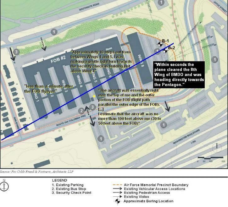
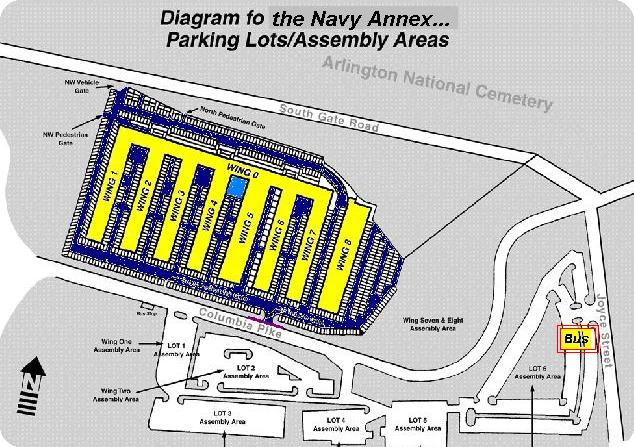