Showing posts with label JREF. Show all posts

Wednesday, October 22, 2008

CIT AMPING UP THE CRAZY

CIT amping up the crazy – nastier witness attacks
10/20/08

[copied over from a JREF thread]

With CIT “to ignore or not to ignore” has been the question. But I’ve just seen some insanity that sharpens the question. Since their flyover witness turned out to be simply toying with the boys, and their miraculous list of 13 NoC witnesses was achieved by including six copies of the same perspective error, the next step was clear: amp up the attacks on those witnesses who can’t even arguably fit their theory. Two cases are worthy of mention.

http://z3.invisionfree.com/CIT/index.php?showtopic=417
They’re preparing to release another video of “CIT's latest encounter” with Lloyd England, the elderly cab driver who was nearly killed when something smashed through his windshield right on the “official flight path.” I’ve kept somewhat quiet on their attacks against him, perhaps because it’s too obvious and oft-noticed – a leading edge persistent bad move. Aldo whines:

[...] we have also had to endure a campaign that has painted us as evil-doers who attacked a poor old man, accusing him of being a mass murderer involved in Pentagon attack when nothing could be further from the truth.
Orly? Please explain.
It is clear to us that he knows what he did and […] he is trying to confuse and cover up this incident while he slips in ambiguous references to how 'big' this operation was.

Oh, well that's... quite... different... from what the smear "campaign" said? This is getting spooky. Aldo is soliciting members at the gang’s forum for "thoughts on Lloyd England and his involvement in the Pentagon attack." This is the second half of the post, which you have to read to even glimpse the depths these loons are dangling over.

It will be clear to anyone who has been following this saga, and who has the attention span, that this man is not telling the truth.

When you watch this footage he may make you angry. We ask that you please view the entire presentation and think about the fact that the plane has been proven beyond a reasonable doubt to have flown on the north side of the Citgo. Again, the implications of this are far-reaching and land right at Lloyd's doorstep since he is the primary one who would have explaining to do.

I can assure you this will be the wildest ride yet in relation to our ongoing investigation. I am sure a lot of you may leave with some sort of sadness or anxiety after watching this presentation, because it will be clear to all who and what we are dealing with. In some sense, I have even felt sorry for Lloyd because it is clear to him and anyone watching, that he knows he is caught and is guilty. I am still in shock over what I watched and heard in these interviews.

I am looking for constructive discussion/feedback on how you feel about Lloyd and what type of light you think he should be portrayed in. I am also looking for solutions/suggestions on how we can get this man or his interviews and our evidence in front of gov't investigators. To be honest, at this point you would have all you need to march into your local representative's office and demand action.

Your participation is appreciated.
Get your Guy Fawkes masks ready, it's a-comin! Good thing they took it right to a legal laevel, it was starting to seem like they were hoping someone would demand answers in blood at Lloyd's literal doorstep. Just so we're clear, CIT has issued no such fatwa.

http://z3.invisionfree.com/CIT/index.php?showtopic=412
Madlene Zakhem, the suspicious south-path testifying Crypto-Jew (their characterization) is hashed over publicly again. Her “bizarre behavior” is finally enunciated – she had her arms crossed and seemed “stand-offish” in her interview, and later cut the lines of communication with the CIT. Oh man, this is sooo juicy… She cut them off right after this e-mail from August 6 2007:

I hope you remember us. We visited your office in August of 2006 with Russell Pickering and conducted an impromptu, unrecorded interview in front of the VDOT/STC where you claim you saw the plane fly over.

We returned after that debating and discussing the information we had obtained. Subsequently, we parted ways with Mr. Pickering.

Mr. Pickering is now publically stating that yourself and the late Mr. Christopher Landis said we were "creepy". This is clearly a problem if you did not say this, as it casts doubt on our integrity and credibility as researchers/filmakers.

Of course, Mr. Landis cannot speak for himself. […]
Cut-in for context: Christopher “Kit” Landis was another VDOT employee, who had given CIT the disc with high res Jason Ingersoll photos. They later noted “he wasn't able to give us specific answers” about the suspicious light poles, and “was notably nervous during our questions.” After this, “Christopher Landis committed suicide,” which they found “an extremely strange and suspicious twist that we can only pray is a coincidence,” but probably not, since it happened “about a week after we had obtained the CITGO witnesses testimony on film.” [source] So, a recently dead guy she knew, however well, is dragged into the conversation. Perhaps awkward... Luckily it was only in passing...
[…] But we feel it is appropriate that you shed some light on this matter as we feel that we treated both you and Mr. Landis fairly and with respect in the limited interactions that we had with you. In fact, we met with Mr. Landis for only a few minutes and said very little while waiting for the CD of photos he was burning for us.

Can you please explain what we did that was considered "creepy" or can you please clarify, for the record, what you told Russell Pickering that would cause him to arrive at this conclusion? Frankly, we believe he is making this up for his own reasons.

Thank you for your time and attention,

Aldo Marquis and Craig Ranke
Citizen Investigation Team
Her response could have been ‘what’s creepy? THAT? And YOU! And it’s getting worse!" But she was more calm, and stating in part:
You are in error and proceeding upon a false assumption. […] I decline your request and I assume that you will not pursue this frivolous claim any further. Any further writing would constitute an unfair burden on me. My desire is to "put these things to rest."”

Too little too late, lady. Aldo's brilliant mind summed up the questions thus:
Is Madlene merely an opportunist who wanted attention for what she claimed was a traumatic event? Was Madlene drastically mistaken? Unlikely. Or is Madlene an operative of some sort?

I have made comments about her jewish sounding last name and possible Israeli accent. Is there a possibility she is Mossad? Perhaps. But one thing is for sure. She certainly was not telling the truth about what she saw on 9/11.

I'm getting the feeling we may just see CIT's evidence in a coutroom someday - as an insanity plea defense.

Tuesday, October 7, 2008

UNO SUPREMO CAPTION CONTEST

October 7 2008, 2am

Any similarity to any internet persona is just that. Over at the JREF, there are some brilliant minds working on the last chapter of the drawn-out Ultima1 saga (name changed here to Uno Supremo to protect his privacy). There's a prevailing notion that a 45-year-old NSA analyst's teenage (?) son has hijacked his dad's identity and files to 'prove' his irrelevant credentials at the forums, to bolster his annoying nonsense and terse insults. I voiced support for this take, but I'm really not so sure - there's a certain confidence to his drivel, and a latent sophistication. While we wait for his promised FOIA document showing that Flight 93 was intercepted (if not shot down - parts of it are classified he says), they're taking in all the little details (like how he shows his own name when posting identifying docs, but not when posting FOIA letters filed by Ultima1), and in at least one case, contacting the authorities over his perceived violations of NSA "opsec." There is certainly something psychological driving this odd little person, and perhaps something disturbing may come of this. I remember an accusation leveled by a critic over at AboveTopSecret.com that I can't relocate with searches (was it pulled finally?). IIRC he got the last name wrong, but called this person (the identity Ultima1 professes to, born Feb 2, 1961) a pornographer and a sick man.

Putting aside the more disturbing possibilities, and the issues of his claimed credentials, we're left with the universally puzzled-over Ultima1, recently banned from AboveTopSecret.com, shortly after I called him a crash-helmeted "geek on a leash" that they keep around to drive traffic. An average of like 50 posts a day, each of 20-40 words, 35% misspelled. Running the hamster wheel all day and night, too easy to make fun of. For those who've been annoyed by run ins with him, here's another caption contest for catharsis. Submit your favorite Ultima1 quotes below, as comments, and I'll do up all or the best, depending how many submissions I get. Or do your own if you got the software. Here's mine, for a starter. Nowhere near the best...

Saturday, September 13, 2008

FAA? WTF?

FAA'S NoC ANIMATION
first posting Sept 13 2008, 12 am
Last update 10/8 2am


So, John Farmer is, I guess, back from Arlington and has received reams of new data, this time from the FAA. He alerted Arabesque and I via e-mail.

The FAA has sent me via certified mail all of the records I requested in my Court action. It is going to take the entire weekend to go through it all, but it looks like the ATC audio and radar records for 1332 – 1344 for Washington ARTCC, Dulles, Reagan, Andrews and Baltimore.

If this turns out to be everything I think it is, then CIT is going to be squirming a little more.


I get a lot of these from him and don't even usually keep up. But the second e-mail here, about the included animation, made me sit up and take notice.

I attempted to send you guys the whole video, but it was too big for some mailboxes. You are the first to see this (I hope) and you just know CIT and Rob are gonna love it!

http://www.youtube.com/watch?v=DQsyt_7c1H8


It shows, more or less, CIT's concocted path over the Navy Annex, with a hard hard right bank/turn and a passage north of the citgo, followed by low level impact (higher only to allow the right wing). I have just been in the middle of laying out the overabundance of North-path clues (there should be roughly nil), including the NTSB's earlier animation to similar effect, so this was doubly ironic as it hit me. This is so insane, the easiest explanation I can think of is... Farmer's pulling my leg?

Two stills, with real and CIT paths (quite app) in the usual colors overlaid. These are from the Youtube version, but Farmer made a higher resolution version available for download and viewing.


---first thoughts, unedited
Any thoughts, people? All I can think of is what - the - fuck?

Or, wait... mmmaybe FAA based it on radar and/or FDR up to the end of that data (the loop and all looks fine on first glance) and then stupidly tried to fuse in the NTSB's apparent final moments, hoping they had some reason for putting it on that path for the seconds they were missing (I'd guess 6-10?) ... Just mysteries. This is going to turn out interestingly.
---

Further Developments
Discussion on this took off all over with the expected rapidity, but a more dynamic embrace than some expected.
CIT Forum discussion
Craig and Aldo, who seethe with venom against Farmer, and aren't 'taking the bait' as it were. They speak of "chess moves" and such... Very sophisticated over there, their apprehension and ruminations! On the other hand, many like Rob Balsamo at the PfffT forum were giggling with excitement, while CIT strongly advised caution, leading to a curious argument about which dishonest track to take. CIT messenger Domenick DiMaggio (aka Terrocell, TC329) also started a JREF discussion thread about it, stating at one point:

they faked it and now they're releasing fake evidence to corroborate cit's evidence and yet still try to prove an impact. and as soon as you guys put the cats down and erase lloyd from the history books they can get away with their evil plans.


Whatwhatwhat? Nonetheless, this is where things took off with both confusion and learning. First, beyond disseminating it, the FAA seem to have no role in this short video. JREF member Gumboot first questioned their authenticity and/or their relevance, but over the first couple pages identified the logos onscreen (www.stk.com and HQ NORAD/USSPACE/AN), and found STK was the Satellite Tool Kit Radar module, marketed by Analytical Graphics, Inc. (AGI), a company that makes software for "national security and space professionals for integrated analysis of land, sea, air, and space assets." He noted "the big golf ball things" seemed to be FAA Long Range Radar sites, and decided this may well be "a radar-based map for NORAD purposes," possibly "to determine which radar sites AA77 passed through, so that 84th RADES knew which data to collect for their analysis." Definitely getting somewhere.

Radar based... north path... I would have figure it out eventually, but Celestrin beat me to it. No wonder CIT were apprehensive - they knew about the false return placed for whatever reason, just north of the Citgo, and I had to point out that it wasn't their north path plane, at least 1,000 feet to low for radar to see. Celestrin made the connect:

RADES data has been available for months and it shows the exact same North of Cthulhu poperties as this animation. [...] Why is it such a wonder that an animation, which most likely uses the same data, would also show the plane further north?


I looked at it a bit the other night and did some graphic comparisons just to see what patterns popped out. I took the peach map from the NTSB's Flight Path Study and set the final map of the animation over it [below]. Note the apparent offset in rotation and location of the loop cross point. I'm not actually sure if the whole path is rotated, or this is just a local distortion from roughness. It is rough and unrealistic in its movements.Farmer instantly pointed out "Look at the loop you idiots, it is a square with rounded corners!" I noticed this too, as did Celestrin. The "squarish" appearance of the turn manuever also suggests that the data, which was used in the animation, wasn't continous." Given 12-second intervals between returns is "too fine for the animation," he wondered "what if one takes the RADES data 1 minute apart," or every fifth radar return, and got this.

When I marked the spots where straight lines start curving, and overlaid it with the 84 RADES returns for the loop, it looks more like this was based on taking every other 84 RADES return (pink dots) as anchor points, and replaced the intervening ones with straight lines or full curves, depending.


This in turn may be a clue to the north path’s appearance. Consider this pattern in light of these final three points of RADES data (the points stupidly connected above]. There may be a different dynamic at play here, but it seems similar in pattern – draw a straight line to, or near, the north point, and then a sharp curve to try and meet, or orbit, the next aberrant return just south of impact. Considering there may be a rotation of the path relative to the map, or vice-versa, and perhaps a slight spatial offset, the actual mapped curve may not be where it looks to be onscreen. Interestingly, when I rotate the line to fit the real path, the turn is about seven degrees, or the amount the NTSB's final map was rotated from its own lat-long grid. [Propos to Farmer for the background image establishing the real path beyond a reasonable doubt]. This is not my final answer, but I'm pretty sure it's close to correct, or on the right track at least.

---
More on the source
Pilots for 911 Truth forum member "Paranoia" looked at AGI's STK.com website and found some interesting information verifying Gumboot's ID. [link]. Of interest is a winter 2002 presentation by AGI President and CEO Paul Graziani, regarding their 9/11 animations. The accompanying powerpoint presentation confirms he's discussing this very simulation - it's pictured on page 5. In his delivered remarks [PDF link ], Graziani explained to assembled conventioneers how "actual FAA radar data was used to accurately recreate the events and model the flight paths of hijacked airlines as well as the responding military aircraft." Actual data, it would seem so. Accurate, only sorta... Of interest is the line "complex problems that once took weeks or months to complete, now take only seconds or minutes when employing software capabilities." Maybe they should have at least spent hours on this one.

Additional update: Just to clarify, this is a NORAD product, not FAA. This powerpoint presentation, from a June 2002 STK users conference, explains the project a little. It covered all four flights, plus responding fighters, all from FAA-supplied radar data.
---
The Video: I refined slightly the final returns angle, and put it together in video form, viewable with notes here.

Monday, July 21, 2008

LOSING FLIGHT 77

July 21
The official accounts of radar/transponder tracking and communications problems with following Flight 77 tried to explain how the weaponized airliner was allowed to get within a few minutes of its target undetected. In total this has been taken by many (including myself) as an impossible or at least suspicious string of errors, allowing a third successful attack one hour into the new war. The Pentagon WAS protected by a mobile air-to-air missile defnse system, or was supposed to be, and the system failed as fighters were first alerted of the danger by a columnar smoke signal saying mission failed.

A useful new entry at 911 Myths regarding this - Losing Flight 77 - is up now to shed some light on it. I haven't really read it yet, this is just a tip-off. Calling on arguments by the relatively respectable and non-loony 9/11 Scholar Nafeez Ahmed, the 9/11 Commission Report and hearings, original interview with Colin Scoggins, and more, Mike W concludes:

Not a single one of Ahmed's arguments entirely withstands scrutiny, then. His most substantial point comes in the differing NORAD timeline, but the problems here are well-known, and Ahmed fails to provide independent confirmation to show that their version of events was correct. What's more, the NORAD tapes (released in full after Ahmed completed his book) contradict their timeline, for example clearly showing that they knew nothing of Flight 77 until after 9:30 on 9/11. And so while Ahmed claims victory, the reality is very different: the balance of evidence continues to support the 9/11 Commission timeline for Flight 77.

Additional discussion at JREF with technical input from Gumboot.

Thursday, June 12, 2008

REHEAT, REASONING, RADII

REHEAT, REASONING, RADII
Adam Larson / Caustic Logic
The Frustrating Fraud
June 12 2008
a bit rough


Note: Lest Reheat think I'm being too harsh on purpose, lemme just say, nah! This is important work and he's right in general, I'm sure. I've just spotted a few things, and I'm such a contrarian...
---
JREF member and anonymous retired Air Force pilot “Reheat” has been offering mathematical proof of the impossibility of CIT’s NoC flight path for a while now. His new paper Debunking the North of Citgo Theory, as published at 911myths.com, further develops the theme, and spurs me to finally note his work. This additional nail in the coffin is couched as “an analysis of the aerodynamics required based upon witness testimony,” a novel approach to the north path analysis – check if it’s possible before asserting it happened and proves that other things didn’t. It’s encouraging to me that someone else feels it’s worth the time to engage this silliness earnestly. I often feel hoodwinked for arguing against something so stupid, but I have nothing to blame but my own obsession. And Reheat has taken issue with the same theory and gone and done math about it – imagine how twisted his mind must be!

His assertion, in this paper and previously, that “the calculations are aircraft type independent” has caused some confusion, and the first thing I did was ask him to clarify. To summarize as I understand it, these numbers WILL apply to any fixed-wing aircraft in the presumed turn, but exactly HOW the G-forces apply depends on the craft. F-16 could do better than 757 with the same turn. The details still escape me a bit, and so I’ll just let the paper speak for itself and offer Brainster’s accurate summary that Reheat has “taken the Morin and Paik flight paths, and then shown the turns necessary to be where the Citgo witnesses claim, then done the calculations to show the stress that the planes [sic] would have experienced trying to make those maneuvers, and that they would have stalled out.”

What I can offer now is some focus on the operative concepts and logic behind this effort, where CIT and allies have claimed straw man, faith-based argument, general scumminess, and disinfo. Unless I’m reading wrong, they have some cause to complain. The paper explains the start point, with witnesses “Edward Paik and Terry Morin who place the aircraft flying parallel to Columbia Pike. There is no problem with this portion of the testimony as it was stated, without CIT’s spin.” The problem is that CIT’s spin is part of what they have decided and the reason this proposed flight path exists to debunk in the first place.

Reheat places Morin where he actually describes himself, but has the path going directly over him there, in a straight line directly parallel to the Pike/FoB edge that has no turn at all from Paik’s position (Paik>Morin listed as requiring 0 degrees of turn). This is the red line in graphics below, on a heading of 72 deg, which is close to reality I’m sure, but not fit for this exercise. Paik himself drew several paths crossing the annex at an oblique angle, which must be ignored to use only gestures from an earlier testimony. And according to CIT, Morin was north of the spot Reheat chose, between the wings of the Annex, as they decided with this ridiculous graphic. Marquis: “when he saw the plane for the brief instant it would appeared parallel to the outer edge of the FOB-which, again, is where the flight path was at; the outer edge Also I am sure he meant it figuratively and not literally, since he can't see the entire flight path.” [not their path from this location anyway – source]

In short, the way I see it, if you want to debunk CIT’s flight path, you need to realize it’s a fiction THEY wrote based on certain interpretations and take those into account – like ignoring the low impact aspects of their Noc witnesses. We’re already factoring that out and presuming a flyover and looking here at lateral turns, NEWS. They did not propose a path literally parallel to the FOB, so including one will distort the path. And it puts one in the line of arguably valid straw man accusations.

Next: a bit technical, sort-of. To be sure I understood the concept behind his turn radii, I stripped away the numbers and made it visual, which helps me. I looked first (and only) at the most moderate curve. I connected the Morin point to the NoC 1 pin, then drew in a simu-curve (orange) to average the heading change more realistically.
Next I checked the headings at Morin and att NoC 1 and found app. 72 and 40, for a change of 32°, which is a bit off from the numbers on the chart, but close enough for what I’m doing here. Then I set a circle around the R1 pin and found it traced that same curve. So this is the right center presuming the plane started south of the Annex at Morin’s location. From there we have another center point for the second turn to impact, this time labeled P1. (“The tags P1, P2, and P3 are the center points of the turn radii for the NoC locations to the impact point at the Pentagon.”) Following the same pattern, we get a curve like this: Which gives us a final flight path like this for NoC1: Now I understand maybe that's part of the point here, but CIT never proposed anything like that, and never needed to. As whoever it was stated in response, Reheat “twists it (pun intended) even more with an S-Turn? Now there is no doubt in my mind why he wants to remain anonymous. Too funny. He must really be desperate to put an S-Turn in there.” Indeed, if I’m reading it right, there is a pronounced S-curve to the proposed path while CIT’s proposed NoC path is all one arc (blue above, their most moderate proposal). Yes, this means Morin was really fudging, but who can disprove that? It's not much further from what Paik drew - his exact lines works for neither official nor NoC paths without fudging. Reheat’s initial straight path as far as the FoB has an edge to run along requires a left and then right bank, whereas CIT has argued for a single right bank over the whole span and crossing the building. These are two different flight paths.

And as far as the degree of the second turn, JFK’s criticism – for once anyway - seems valid here. Unless I’m missing something, there’s no reason “the tags P1, P2, and P3” need to be THE “center points of the turn radii for the NoC locations to the impact point at the Pentagon.” It doesn’t need to fly the full arc 180° - it could fly nearly straight after the Citgo starting from a less northerly heading there. Let me help out here with a possibility:
Someone else can crunch the numbers on that.

If nothing else, this episode illustrates the absurdity of trying to concoct a real flight path from witnesses by focusing on discrepancies rather than correlation, and the dangers of selective reading - someone, or some part, always has to get thrown under the bus. And besides, if someone "must really be desperate to put an S-Turn in there,” someone needs to look into the chaps who put out this desperate s-s-s-swerve a while back and started all these tortured calculations.

Monday, June 2, 2008

WHOT DE 'ELL? SERVERS NOT FOUND?

June 2 2008 1am

I hate to have to keep reporting weird things but this can’t go un-noted. Since last night this has been the status of JREF's forum: The Forum is closed for maintenance. For about the same time, this is what the Loose Change Forum gives me: Safari can’t open the page “http://s1.zetaboards.com/LooseChangeForums/index/” because it can’t find the server “s1.zetaboards.com”. This simultaneous cessation of two discussion forums (one VERY active) presumably will be short-lived and explained soon enough. But it is very mysterious and leaves me repeating, as an old co-worker had a way of pronouncing it, “Whot de ‘ell?”

The bickering, sniping, and so on between the two forums had been getting about insane - personal info revealed, sock puppets, IPs tracked, old gripes, accusations, veiled threats, screen caps, it was all hard to keep up with. Did something in there snap something, like, legally? Much of this drama was centered in the areas I'm watching - Conspiracy Theories at JREF and The Pentagon at LCF – and the bogus theories of Citizen Investigation Team (sorry, the bogus theories of the Citgo witnesses, the people of Arlington, etc.). The friction was between the team itself and increasingly its supporters and detractors inside and outside ‘the Movement.’ Was it from this flamethrower battle that a simultaneous cessation of both forums came?

It didn’t seem so, since CIT’s own discussion board was still up last night and earlier today. Then I went to check again and got this: Safari can’t open the page “http://z3.invisionfree.com/CIT” because it can’t find the server “z3.invisionfree.com”. Whole servers are down at Zetaboards and Invisionfree? Or is it all on my end? And whatever’s going on at JREF? I do not know my computer stuff – is this a virus or something? Is it subject-matter oriented, or legal? There were no announcements or warnings sent to members, that I saw. it just happened.

For those desaparately adrift due to all this, I’m still afloat, it seems. Climb on board here, and help me sort it out. Comments moderation off for now given the catastrophe. :)
---
Update: As I should have suspected, no multi-forum catastrophe - see comments below - LCF is working for others, so app. I've been banned from reading it, It's more invisible that the Pilots for Truth forum now. JREF has a genuine problem and the page says they'll be up again soon. CIT is back to normal as well. And normal is... well, you should all know by now. Serious seekers and exposers of the "Truth" ban posting for members who disagree too well (CIT), ban reading of subjects for those who don't register for future banning (PFTF), and it seems ban their site from appearing to certain not-even-members anymore (LCF, hijacked by CIT/PFT). Also I found I'm not able to comment anonymously even at ATS, like a normal person who hasn't pissed them off once can do. So with two of these four forums unreadable and the other two unanswerable, I have JREF and 911Bolgger in my communications repetiore at the moment. So... I won't be following the latest lies, distortions, and idiocy as close anymore, which will be good for me and I guess for them.
---
update: Tuesday afternoon - LCF opens for me now. Whot de 'ell? Well now I don't really care but I have something to do for the next ten minutes. Oh, I guess it'll only take two minutes to catch up on the news.

Monday, May 19, 2008

THE FLYOVER THEORY GETS SOME FAUX CLOUT

THE FLYOVER THEORY GETS SOME FAUX CLOUT
Adam Larson / Caustic Logic
The Frustrating Fraud
May 19 2008
updated 5/22 1am


Last Thursday night, May 15, saw a remarkable happening of Fraudsterism via the relatively high-profile venue of the Air America radio network and Richard Greene’s Clout program, of which I’d never heard until two days before the show. This tip-off, brought to my attention by an e-mail from a friend, was a press release by Pilots For 9/11 Truth.

05/13/08 - We hope you'll join us regarding the issues surrounding the Pentagon Attack this Thursday, May 15, 2008 at 9pm Eastern on Air America Radio with your host Richard Greene, Co-Produced by Rob Balsamo, Co-Founder, Pilots For 9/11 Truth.
Guest will be:
Craig Ranke from Citizen Investigation Team
Rob Balsamo, Co-Founder, Pilots For 9/11 Truth
Kevin Barret
Individuals supporting the govt story – TBA

[emph mine - original posting]
Background on how Greene and the Pilots hooked up back in March.

For this "Week of Truth" installment, the TBA part wound up meaning, it seems, ‘tiny blocks allowed’ for the only debunker to both be invited and respond, Ron Weick of Hardfire. He took his invitation to a JREF thread but scored no supporters. To hear Balsamo talk they were cringing in fear but really it looks more like skulking and/or sighing in exasperation. I had several good reasons for not getting directly involved, but did try to get a message through to Greene. I urged him to have CIT and PFT on with their promised groundbreaking revelation, but to be aware of my findings about their previous findings. I put the ball in his court, where it already was. If Greene doesn't research his guests, or ignores that they are promoting hoaxes, that's his own problem.

On the other side the list of ‘truthseekers’ invited for the program eventually expanded to include Barbara Honegger, Col. George Nelson, and even the eminent David Ray Griffin was able to take some time to elaborate his decrepit, myopic opinion of the Pentagon attack. Barrett apparently backed up to make room and did not appear, which helped, but… CIT's Aldo Marquis later complained of this over-booking "we are being drowned out. Two many chiefs and not enough Indians. This is why we will fail. We have incredibly important evidence and Ron Weik and Barbara Honegger get more air time than Craig and Rob did. Sucks. All old info all bunk. Whatever, you guys heard it. We've got a flyover witness(es)." [He's not exactly sure if it's plural yet.]Update: the Clout flyover witness

I too was mostly looking to hear the portion where the original guests were featured and this revelation triumphantly ejaculated, but unable to catch it live I had to rely on the later-posted audio links. Ranke and Balsamo were pushed to the last block, the link for which was the only one that didn't work (and still doesn't four days later). Due to delays in getting the segment in question (see below), the review has been delayed. I'll post it separately.

Clout Links:
- Clout episode blog page Entire show minus final segment with CIT and PFT available for listen here, as well as 200+ comments (several by myself and "Hetware" it seems, have been deleted with no explanation).
- Entire show in compressed (poor) wma format, but in one convenient zip file. Provided by Pilots For 9/11 Truth. (theirs is part 1 here, understandably.)

Sunday, March 2, 2008

BANK NOTES

BANK NOTES
Adam Larson / Caustic Logic
The Frustrating Fraud
February 15 2008
updated 2/26 2am


Do You Even Know What A Bank is? Just Curious.
- Craig Ranke: "The plane banked over the Navy Annex [...] Did you know that even Mike Walter claims the plane banked?"
- Craig Ranke: "a bank in his view AT ALL completely destroys the official story."
- Aldo Marquis: "Ever speak to Mike Walter about seeing the plane in a bank? Just curious."
[source for both]

He asks because they did speak to Walter about the bank! 
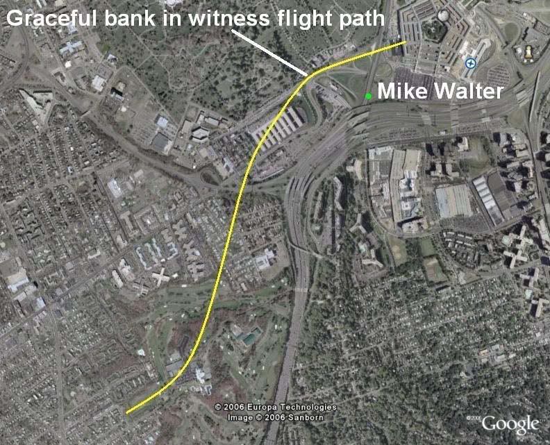
At JREF back in April 2007 Ranke (as Lyte Trip) posted this text and graphic:
"He contradicts the official flight path. He claims he saw the plane do a "graceful bank" before gaining speed and flying into the building. There would be no "bank" in the official fllight path whatsoever that he could possibly see on route 27. But there most certainly IS a bank in the eyewitness flight path that we report!" [emph mine]
So Mr. Trip and his fellow citizen would have us believe that in the 'official story' "there would be no "bank" [...] whatsoever that he could possibly see on route 27." This is flat false. To understand what's up with this I need to clarify some confusion/conflation. To some minds a 'bank' is indistinguishable from a 'turn,' but a turn, as we all know, is a general changing of direction, while bank is:

"The angle between the wings and the horizon, as viewed from the rear of the airplane. An airplane with its wings level has zero degrees of bank. [...] Banking makes the plane turn. [...] This process is also called Roll." [source]

There is a natural, inevitable correlation between the two; usually banking means a turn just like smoke means a fire. However, just as smoke and fire are two different things, so are these two, and they can in fact be separated. A quick scan of anecdotal evidence - googling "bank without turning" and variations for about two hours - shows that its possible, and involves countering the tendency to turn using the rudder. In fact the rudder seems to be the key to both turning without banking and banking without turning. The best explanation I found is this, by Peter Sagar.

So when someone describes a plane 'banking,' they could possibly mean it colloquially as a turn, or they could mean - well, a bank of the wings, depending on the witness. This is a very important point to remember as we progress here, and when reading the analysis of Ranke and Marquis of Citizen Investigation Team, who make no such distinction. When they hear or say 'bank' they think or mean a turn, and refer to actual bank as 'tilt'. I've never heard them discuss tilt that I can recall, just bank, of course meaning turn. [explanation extracted here]

Discerning then the difference between the angle of a plane's wings and a general change of direction over space, let's address the normal relation between the two. If the right wing goes up, the left wing goes down, and the airplane is said to be in a bank to the left, and will naturally turn to the left. Any kid who zooms around on a bike will understand the concept. There are certainly formulas for bank/turn ratios, but in general, a level plane will go straight, and the steeper the roll, the tighter the resultant turn. How it's measured is seen from behind - right wing low is a positive number, and right high is a negative number. The tilt is measured in degrees, with level wings being 0 and wings straight up-and-down (plane sideways) being 90 degrees. Airliners try to stay level - a bank of 40 degrees is considered extreme, remarkable, rarely-seen, memorable, etc... Please keep this in mind.
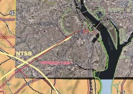
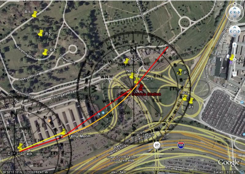
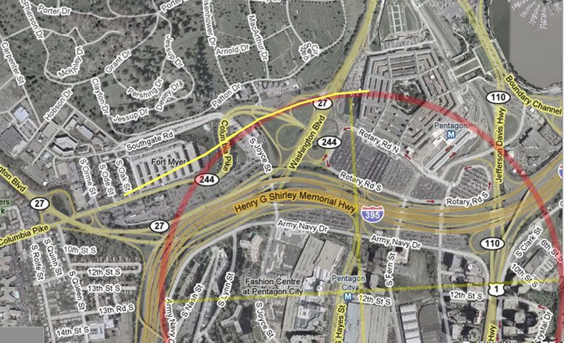
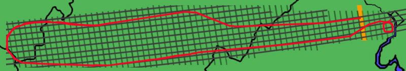
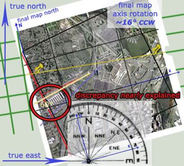
Official Bank?
As CIT point out, the official story delivers a straight-shot path, about 70 degrees magnetic, 60 real, for at least two miles prior to impact. Therefore, any bank angle in the final stretch would be slight, or otherwise offset to keep straight. 'Straight' in this case is relative - the path may have had a slight bow that was not noticeable on the small scale most people saw it on. So in CIT terms, a straight line means no bank, and no bank probably means no tilt.

While there is no discernible turn in the official version of the final stretch, CIT will be saddened to learn that there 
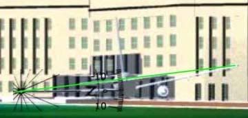
is a bank [tilt] in the 'official story,' recorded in the physical evidence. A roll of about -6 degrees is evident in the wing prints at the facade impact point (IMO a bit more level and a few feet higher than shown here - ASCE graphic measured by me). This bank is generally consistent with the right-left damage before impact: the VDOT camera pole, tree damage, three light poles, diesel generator, etc. encountered by the right wing and engine at their respective heights, and two light poles, vent structure, trailers, and building foundation encountered by the left wing and engine. Though exact numbers are hard to deduce and the minutiae hotly debated, it's all consistent with a slight left bank like that shown here.

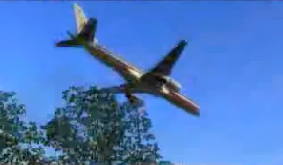
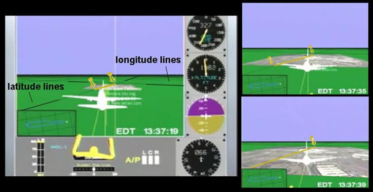
Due to the confusion over terminology, and other factors, debating this issue with CIT has been baffling, as they flatly state 'so-and-so wasn't in a position to see the bank,' etc. Couldn't see the bank? For God's sake, I railed... here's their own flyover animation: If I were right there being fooled by the flyover, nothing could fool me about its bank – about zero, perfectly level. So to be clear, they mean 'turn' in these cases and it makes sense that few witnesses would see a whole turn on the scale of even their tight yellow swerve. But since a turn is a change from one heading to another, and marked by a wing tilt as they call it, their recent eagerness to deny witnesses can see headings at all and their silence on 'tilt' are troubling. This leaves their findings very vague - and malleable.
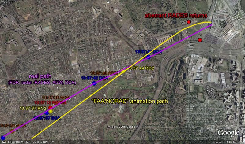
FDR Insights
The numbers recorded for 'roll' in the original CSV file readout of the flight data recorder obtained by Pilots For Truth and others are instructive in what to expect in the last moments as far as turn and tilt. This quick list shows key points before and during its final turn (9:34-9:37, a right bank for nearly a full circle) and end of data:
h:mm:ss - roll
9:32:55 – +3.5
9:33:46 – +1.1
9:34:01 – +8.1
(nearly 8 degrees change in one second! The loop starts here.)
9:34:38 – +29.5
9:35:55 – +37.6
9:36:32 – +16.9
9:37:10 – +10.9
9:37:20 – +2.8
9:37:30 – +3.2
9:37:35 – +2.1
9:37:40 - -0.4
9:37:41 - -0.7 (-0.3 change/sec)
9:37:42 - +1.1 (+1.8 change)
9:37:43 - +3.5 (+2.4)
9:37:44 - +6.3 (+2.8)
[note: C-130 pilot Steve O'Brien estimated the plane's bank as he passed it as 30-40 degrees. By radar he passed it around 9:35-9:36. See above for comparison.]

At 9:37:36 the magnetic heading first hits 70.0 degrees and thereafter is steady, alternating between 70.0 and 69.6. Roll at that time is nominal and then shifting even to a slight left bank, back to right near the end, and then what? A final reading of 6.3 would mean right wing was tilted down to about the same degree the physical evidence has it tilted up, as Pilots For 911 Truth have celebrated. But the FDR is no help in this area – it stopped recording, or was truncated, or something, shortly before that point, somewhere in the neighborhood of 6-8 seconds shy of impact, which would have been around 9:37:50-55. With 12-13 degrees change required that’s about 2 degrees/sec or less, which fits previous trends quite reasonably. But this is all guess work... the machine is silent, and we have the physical evidence and the eyewitnesses, one of which we've covered.

Eyeballs on Wings
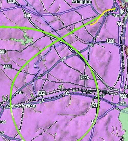
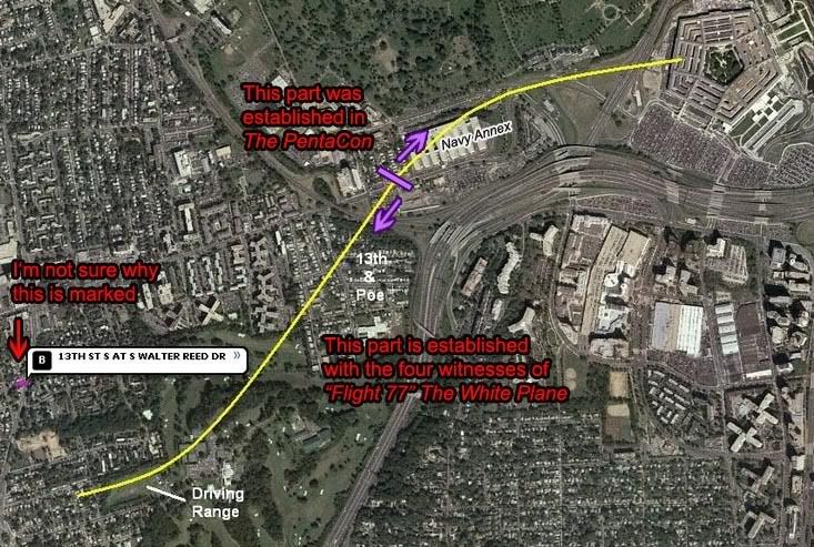
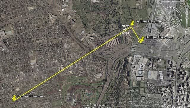
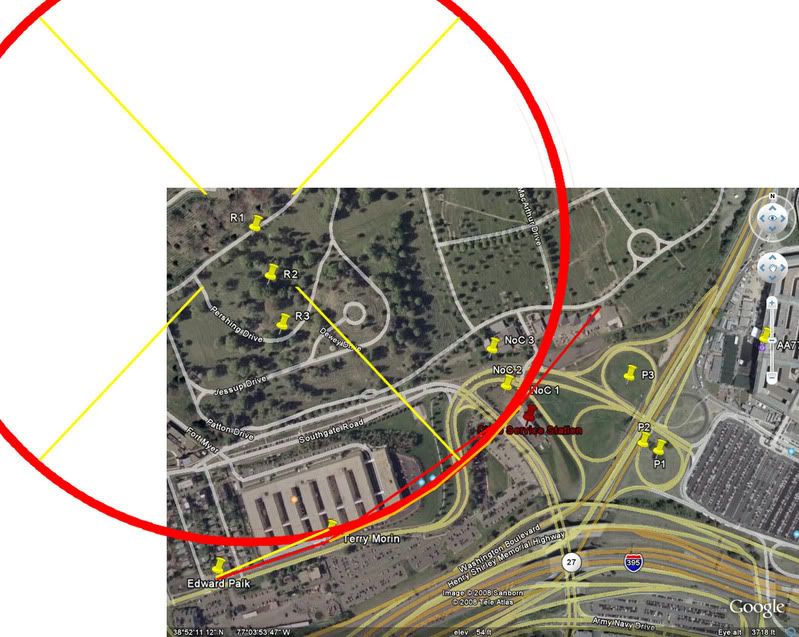
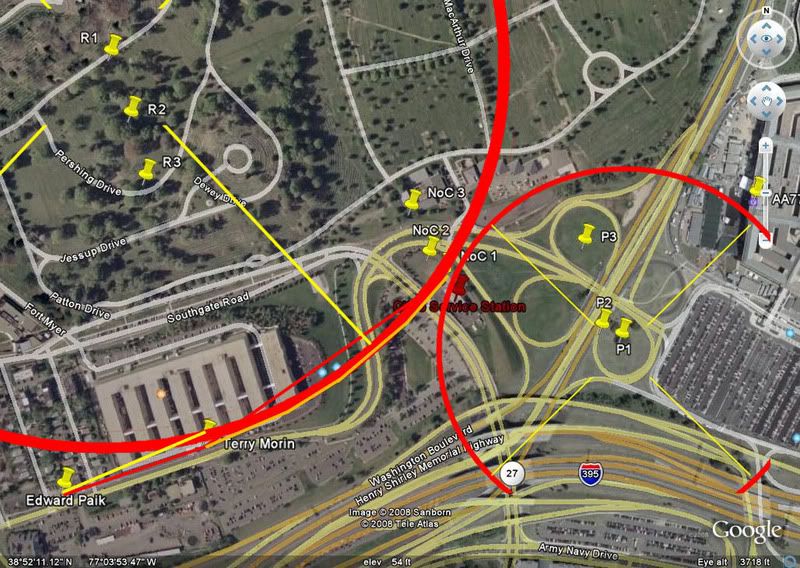
So in establishing turns, even if we're calling them banks, it's important to note the 
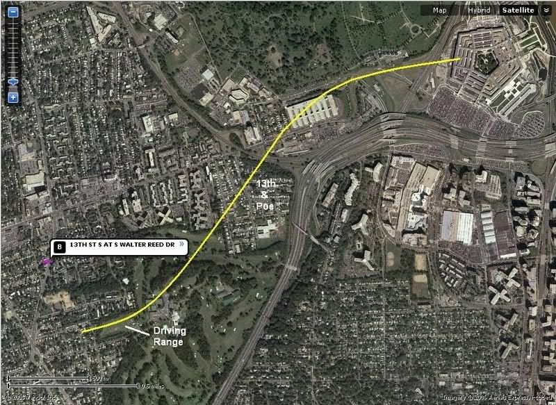
direction of the bank. The CIT witness-adduced swerve is shown above in yellow, to scale with the 'official' loop in green recorded by FDR and radar from 9:34-9:37. Check the sample rolls above at these times, and realize the CIT swerve would require a sharp left turn over the driving range, in excess of 40 degrees, a rapid correction, then an equally sharp right turn over the Navy Annex, so a right bank, with left wing very high.

One witness CIT is very excited about, Sean Boger, with a prime view from the heliport, does seem to describe this: "As he was coming towards me it just seemed like he was tilting the aircraft to his right." Barring some confusion (tilted meaning up or down? His right or the plane's?) this sounds great. But he also puts the plane north of the Citgo, so a grain of salt is in order. I also note that as an aviation pro, Boger might've been expected to use the proper term bank, but instead chose the more vague 'tilt' which CIT settled on, as supporting the plane's right... bank.

Which it would, of course. Right tilt-bank means right bank-turn, and this is supported by others in conflict with the official story. Like Mike Walter we hear. 
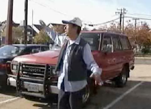
LCF part-time member Bileduct calling CIT on using Walter's banking report: bileduct perma-banned, thread closed. In this well-managed thread, Bileduct ejaculated: "You have indicated that Mike Walter described the plane in a banking maneuver over the Navy Annex. Your exact words were "He described the bank in detail to me, Aldo, Dylan, and Russell." My question for you... Did he say the plane banked to the left or the right?" To this simple question Craig responded "To be honest I don't remember. […] But I do recall that he had the plane making a "graceful bank" as it approached, not directly in front of him." Bileduct gloated for a moment then posted one of Walter's published accounts:

"I will never forget that day, trapped in traffic and then I rolled down the window and heard the sound of the jet overhead. [...] I looked up and saw the underbelly of the jet as it gracefully banked, then I watched in shock as the jet basically lined up the Pentagon in its sights and began to scream towards the mammoth structure." [emph mine]

'Underbelly' means it was above him - obviously - and also tilted at least somewhat right wing high. This is a left bank, not a right one, in which case its belly would be turned away. And that this happened in the distance - where the hairpin tirn to the right was supposed to be happening - was doubly troubling. Craig quickly responded "I do not believe or trust Mike Walter for a single second and we have plenty of evidence to show deliberate contradictions in his account. [...] He could not see the underbelly. He did not see the underbelly. He could not have seen the underbelly or a bank on the official flight path as well. This is just ONE of many fatal contradictions demonstrating how Mike Walter's statements are not truthful." Oh, and the tilt-bank wasn't necessarily OVER Route 27 [he doesn't describe it there - abbsence of description = description of absence]. Though the building damage shows a left bank still evident AFTER the road.

So what do other witnesses in the area say?

- Anderson, from far to the north and high up: "I watched in horror as the plane flew at treetop level, banked slightly to the left, drug it's wing along the ground and slammed into the west wall of the Pentagon exploding into a giant orange fireball."
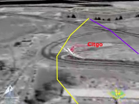
- Elgas, same basic position as Walter, facing north on 27: "The plane just appeared there, very low in the air, to the side of (and not much above) the CITGO gas station that I never knew was there. […] I saw the plane coming in slow motion toward my car and then it banked in the slightest turn in front of me, toward the heliport [...] It was far enough in front of me that I saw the end of the wing closest to me [right] and the underside of the other wing [left] as that other wing rocked slightly toward the ground." She cites a turn, using the word bank!
- Elliot, south-southeast of impact, watched it for several seconds: "I looked to my left and saw the plane coming in [...] It was banking and garnering speed."
- Hagos, on Columbia Pike (?): "It was tilting its wings up and down like it was trying to balance."
- Hemphill, at the east end of the Navy Annex, perfect view: "He was slightly left wing down as he appeared in my line of sight, as if he'd just "jinked" to avoid something. As he crossed Route [27] he appeared to level his wings, making a slight right [wing low] adjustment."
- Marra (on I-395 south of impact?): "The plane rolled left and then rolled right. Then he caught an edge of his wing on the ground." [which wing is unclear]
- Morrin, outside Navy Annex, under its path, plane dipping too low to see]: "I could now only see the tail of the aircraft. I believe I saw the tail dip slightly to the right indicating a minor turn [roll] in that direction." [The bank as it passed him is unclear. It was high above him and just south, but he could see the AA markings on its left side, which might mean it was in a left bank]
- Owens: "the left wing dipped and scraped the helicopter area just before the nose crashed into the southwest wall of the Pentagon."
- Storti, apartment, Crystal City: 'he watched the plane cross over Route 395, tip its left wing as it passed the Navy annex...'
- Thompson: “The plane looked as if it were coming in for a landing — cruising at a shallow angle, wings level, very steady.”[this shows the bank was relatively slight - ie graceful - which might explain why there aren't more bank reports]


The best fit for all of these is a moderate left bank over the Annex, right wing high, leveling slightly just before impact, but not enough to keep the left engine from - more-or-less - hitting the ground in the last instant. And of course impact itself looks to have happened at a bank of about -6 degrees. But this was faked, and we know there was a right bank, thanks to CIT's witness verification. Except Walter. Verified LIAR!
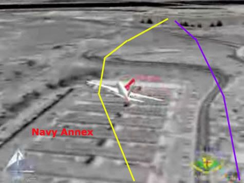
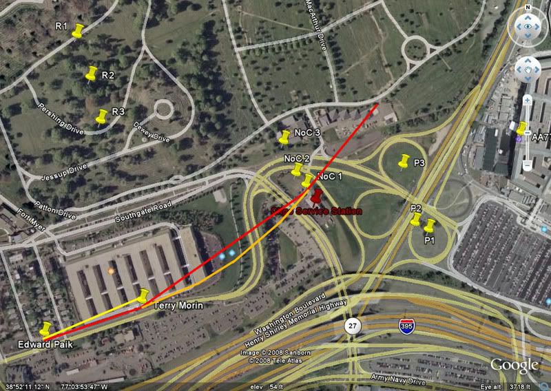
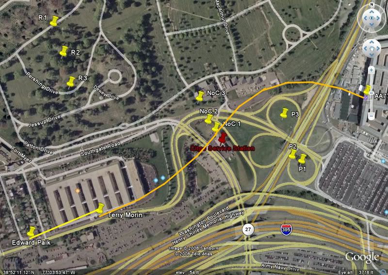
But who the hell is this guy? Why does he keep impersonating the plane with his right hand higher than the left? Wasn't he in the best spot to see the sharp right bank over the Navy Annex? This is Edward Paik, interviewed by CIT in 2006, who places the plane's overall path fairly close to where they needed it. In the interview he’s never ASKED about tilt-bank, and doesn’t TALK about it. CIT informs me in an earlier interview he was asked about it but said he didn't notice one. His lines are essentially straight indicating wings about level. Yet at 11:42 in The PentaCon [verify, go ahead], describing the black wings, he extends his arms, right hand high, relaxes the gesture then repeats it the same. Is it just some tic, a spinal misalignment? No, at 12:52, striking a jesus pose, facing the OTHER way he somehow puts his LEFT hand higher to indicate the right wing. He even seems to think about it a moment first. Coincidence? Perhaps. But interesting.

CIT claims I made up this left bank gesturing of one of their prime witnesses. They claim he didn't remember one at all. They claim the plane was bank-turning right over him. It had to be, and about halfway to knife-edge. This would necessarily mean an extreme tilt-bank, right wing very low. He might then talk about the wingtip being too close, rather than the whole plane. He might remember such a remarkable tilt when first interviewed. He might gesture it left hand high. He might draw at least a slight right curve in his path, if he saw what CIT insists he saw. Ed Paik does none of these. Just the gestures above.

Composite path turns required: one to the left, one to the right.
PentaCon Smoking Crack version witness bank reports: zero right, one left (perhaps anyways)
White Plane witness bank reports: zero left, zero right.
Completely made up extreme turns to play connect-the-dots? Two. One left, one right.

Estimated wing bank accompanying the right turn according to experienced pilot 'Beachnut'?
"Take a google earth with the yellow path from Pentacon! You then find the radius of turn. From the radius and the speed from the FDR you get the need for something like 80 degrees of bank and 8.7 gs with the wings falling off in a big snap! Just take the radius and speed and look up an aircraft turn equation. Makes the turns required by the CIT to be impossible; as in made up."
---
Additional Discussion at Above Top Secret:
Main thread Craig wouldn't touch
Vs. thread Craig revived as a distraction, where we chatted a bit about bank (pages 3-4).

Monday, February 25, 2008

"PENTACAR" UPDATE

"PENTACAR" UPDATE
The Frustrating Fraud
February 25 2008 2am
update 2/29 12am


Previously I had decided, based on a lead first offered by a fellow LCF member, that the mysterious “Pentacar” photo was probably taken just a ways north of the Pentagon. I became curious after seeingthis damaged car supposedly near the Pentagon on 9/11, as presented by Mark Roberts (aka Gravy), whom I asked about source and info to no immediate avail. About a week ago I received an e-mail from fellow JREFfer “Mangoose” alerting me:

“I know the source of the "Pentacar" photo. Gravy must have found it at the Here is New York site (http://hereisnewyork.org/index2.asp), just type "8029" in the search box. My copy of the photo was downloaded in 2002, so it has been at the site for at least that long.”

I immediately checked and there it is. No recent hoax it would seem, but a legit and long-available piece of evidence I’d just never seen before. There are no credits or info attached, just a tag number - 8029. But at least now I know who I can ask for more info, though it seems they’re understaffed, so I’ll just look at what’s there for any corroboration. There are precious few clues to help us confirm the suspected location of the damaged car. Mangoose suggested:

“Also, check out #8026-8028. The HINY site often lumps together photos from the same photographer, and these three photos are clearly from the same person, and they immediately precede the photo in question. They are also from the area on Rt. 27 north of the Pentagon, as suspected in the blog, but #8028 appears to have been further away from the building than #8029 (if the identification of the location in the blog is correct). If it was taken by the same photographer on the same walk down Rt. 27, it also would have been taken within the first hour after the attack -- as the other photos were taken then as well.”

I’m done for now with analyzing this stash for clues to the Pentacar’s location, and it seems more complex than that. There is some kind of pattern at work but I can’t discern it. Several pictures from the 7000s also seem to fit the general area of north of the Pentagon, including the two closest to the location I've tagged. Some in the 8000s seem out-of-order and some others seem to be missing from the sequence. Among the photos of interest, which can be found also by entering their numbers:

7717 – Nearest view – south end of the bridge the car may be just south of, looking south. Unfortunately it’s panned off to the left and the area in question is just off-frame.
7774 –Near view – north end of the same bridge in 7717. Not entirely clear at this resolution but promising - see below.
8026 - entrance to north parking lot – no clues.
8027 – entrance to north parking lot – no clues.
8028 – near an underpass/bridge nearly a mile north of impact. No direct clues.

Here are many of the shots mapped out by my reckoning:
And here is a crop of 8029 compared to a crop of 7774 (contrast and saturation adjusted), with a highlighted area across the bridge. Is that the Pentacar? Actually I think not. Perspective is tricky here, but I think the spot I'm looking for is just a bit further back than that car. I'd say I'm done here, but did get an additional excellent lead from an anonymous commenter. I have a possible name now (previously published, indirectly, but barely mentioned) for the owner of that car, and since this is an interesting case, I'll be looking a bit deeper. The commentary seemed not to want the info published, and I relish the idea of a secret here, so that lead is secret at the moment.

Wednesday, January 23, 2008

GRAVY’S PENTACAR PHOTO

GRAVY’S PENTACAR PHOTO
Adam Larson / Caustic Logic
The Frustrating Fraud
January 24 2008 4pm


Recently I stumbled across this photo, which was posted at WTC7 Lies Pentagon evidence pages [page two in the middle]. I've never heard of any such damaged car. People mention Lloy'd cab with its windshield smashed by a light pole fragment, and a clipped truck antenna, that's it from what I had seen. In this case the passnger side window taken out; someone could've been killed, so it’s rather surprising this wasn’t in the news. Lloyd's car with not a scratch on the hood gets all that attention and this gets nothing until WTC7 Lies puts it up apparently out of nowhere. It's labeled Pentacar.jpeg. It has no caption, sources, anything. The site links to main 9/11 links page which in turn is part of "links for 9/11 Research Compiled by Mark Roberts,” also known as the JREF forum’s eminent debunker “Gravy.”

So I contacted him for more information, but he didn’t have anything ready. It was from a large collection and vaguely sourced to begin with, he said. With digging up the info it came with on his ‘to-do list,’ I’ve dug around for clues linking to it on the internet but nothing has surfaced yet. In the meantime, he did offer as precedent an account from Tony Terronez, who was headed north on Route 27, in front of the Pentagon and headed away from the impact point when the plane screeched in and impacted behind him. He saw the explosion in his rear-view mirror and ducked when he saw debris falling his way.

“[…] and I heard the pitter-patter of pebbles and concrete bouncing off my car. And the next thing you know, I heard this big crash come from somewhere. It sounded like glass being shattered and I thought maybe, at first, it was one of my windows so I popped up to look but everything was fine. But when I looked to the car next to me I realized that something went through (the driver's) rear windshield and shattered it. There was a hole where you could see that something went through it.”

Here we hear about additional car damage not widely-mentioned elsewhere and not seen in photos. This case was apparently from building or plane debris from the explosion (which by deflection angle would scatter thicker over the north end of the crime scene). This is clearly not the “Pentacar,” which is another story. I immediately noticed that the major dent in the door there along with the roofline damage is consistent with at least one light pole at the scene, the little-seen pole #2 with its curiously bent end. By my mapping, this pole would have been hit low by the left wing, but this bend appears near its narrow top (light truss arm missing), which I had taken as a sign of an undiscovered secondary event after it started falling. Here is my graphic, using a Bob Pugh photo of pole 2 with bystander for scale.
Now this could well be a simple geometric predisposition – I like things that fit. As others have noted, it appears the car would have been still when the pole impacted. However the scuff mark nearer the back of the car could be from the detaching lamp head, passing that spot either from the pole’s own momentum or due to the car’s. I’d wonder if the driver had time to screech to a slanted halt on seeing something headed for him, just in time to put the empty passenger’s side in its path. This could also be some kind of building debris perhaps or something else altogether. And as I stated in an earlier Loose Change Forum thread I started, as far as I could tell “this could be a simple hoax, an unrelated photo someone decided COULD fit at the Pentagon and dropped to see who bought it.”

However on the chance it is authentic, it’s worth some more analysis to determine where it was taken. Some clues offered by the scenery include: trees on both sides of the street, 2 or 3 lanes of traffic each way plus a narrow shoulder, no high concrete divider as seen elsewhere on Route 27, an angled guardrail and narrowing sidewalk on the near side, a sign and a light pole near each other on the other, set on a wooded down-slope. Shadows indicate that if this is the morning of 9/11, this car must be facing north, on the side closer to the Pentagon – in itself a problem, as that’s the wrong lane to be in to have a pole knocked into the passenger’s side by a plane approaching from the west.

The only useful help in that LCF thread came from member “Fedzcametogetme,” and it followed some paranoid accusations against me. ‘Fedz’ as I call him then dug in, and actually drove through the area several times as well as looking at satellite photos and highlighted one area on Route 27that matched the characteristics of the Pentacar photo. While I’m not even sure the photo is ON route 27 on 9/11, if it is I accept this as the most likely – the only – spot it could be (highlighted below in purple). [r-click, new window for full-size]

Consistent points: lack of any tall divider, sign-pole placement, tree shadows on the east side and trees and downward slope on the west. The only problem with this locale is that the off-ramp curving away is not evident in the photo. An overpass bridge would be the next thing visible to the right if this photo weren’t cropped,

Looking closer and using current satellite imagery, peripheral clues also match to a high degree. The sidewalk (grass strip?) seems to narrow in both photos. Sign-pole placement, the down-slope, the same problem with off-ramp unseen, The guardrail is present in satellite photos, beginning just before this spot just as the median ends before the bridge, which itself has given me useful insights on traffic planning works.

Here I will outline scenario by which this could be an authentic case of a car damaged by pole 2:

The driver was headed from home (north) to work (south), in the relatively empty southbound lane of 27 when the 757 blew noisily up Columbia Pike. Sensing its descent and predicting trouble, instinct kicks in and the driver skids to a slanted helt with the passenger’s side (empty) facing the plane’s path somewhat as its left wing severs pole 2 and sends it against that side of the stopped car, with its base on the pavement. After impact, the driver gets out, thankful to be alive, and tilts to pole up and over the embankment to where it’s seen later. The driver then reconsiders original plans. Near-death experience, etc… good enough reason to head back home. Traffic rules be damned, he/she turns around and drives against the stopped traffic, weaving around the scant cars, looking for a place to get in the northbound lane. “How am I gonna get in tho? It’s bumper-to-bumper,” he/she thinks, driving along the double then single divider. At its end, the car turns right and half-crosses the low median, waiting for the crawling traffic to give him space. Gestures are exchanged, a space made, and the driver pulls clear across to the pull-over lane and parks to think some more and take this picture. Then to home to share the tale and to catch the news of what the hell is going on. Say in 2005 or 2007 the driver finally releases this private photo to counter the growing ‘conspiracy theories,’ but the chain of custody was left unclear by some sloppiness on whoever’s part.

This of course raise a host of issues with regards to Lloyd England, who would have been right in front of this driver, and about the lack of interaction between them, and other such issues regarding traffic flow and timelines any critic might toss out. I only offer this as a basic description that could make all this evidence line up. Otherwise, it could be a motionless car stuck in northbound traffic north of impact, getting hit with some peculiar building debris like Terronez describes.

Alternately, it could be an unrelated photo from another time and place, put out by whoever for whatever reason. As Fedz at LCF finally said, in agreement with the stance I took almost right off “i wont speculate any further until the source of this pic can at least make some claims or offer some background info about this pic. since all we have is a pic but no source or even a caption, then its futile for me to dissect this matter any further.”

I offer a friendly challenge to Gravy to come up with a little info, or a confirmation of how little there is, or something. I’ve been flippant at the Loose Change Forum calling this a probable hoax, but of all people I’m truly open to whatever it might prove to be.

Friday, September 21, 2007

NTSB ANIMATION INTERNAL GEOGRAPHY PART 5

NTSB ANIMATION INTERNAL GEOGRAPHY PART 5
THE FINAL MAP: A TURN FOR THE WORSE
Adam Larson / Caustic Logic
The Frustrating Fraud
Finished Sept. 21 2007
updated 5/26/08


Very interesting thread at Above Top Secret when I posted this.

The Final Grid Analysis:
In my previous studies of the global grid beneath Flight 77 in the NTSB’s animation, I had found that the grid does not conform to real-world lines in proportion, scale, or orientation. I’m not 100% sure on the exactitudes of the final take seen below, but by multiple points of evidence it’s the best fit with what I was consistently seeing.
This is based on extensive tracking of 11 east-west-ish “latitude” lines at multiple points in the animated flight as it crossed I think 68 apparent longitude lines. The official path shown here in red is oriented to true north, in agreement with maneuvers and time in the animation, and verified at multiple points as consistent with lat/log data from the csv file. So the red is pretty solid beyond minor variations in my graphics. The less-than-level grid seen here is also not quite straight. Straight lines just weren’t cutting it to explain all intersection points I noted, so I used slightly bowed horizontal lines. Whether or not this makes sense, the exact slant changes little over a 300-mile span; oriented about 6° CCW at the south turn (left-hand side) and ~9° CCW from due east around the Pentagon on the right.

If the curve freaks you out, let’s presume straight parallel lines, but rotated in the neighborhood of 5-10° counterclockwise from real-world latitude lines. In fact, it’s at the high-altitude south turn end that I’m least sure, and lower altitudes at takeoff and near the end make readings there more precise. So if the lines are straight, they are in the upper range, no less than 8 degrees. The overall rotation looks close to magnetic declination, which I’ve established as 10.08° counter-clockwise at that time and location. This indicates that perhaps I read some crossings wrong enough that I’m off by a few degrees and the grid was rendered with magnetic north used as north. It doesn't sound very sophisticated for the National Transportation Safety Board, but something has got these lines off-kilter.

Anyway, we now have two different orientations to consider when looking at the animation flight path – the on-screen global grid relative to true geographic heading. So let’s throw in a third level that comes into play in the animation’s final seconds and the question that got me interested in this to begin with.

The Overlay Map: Tacked-On Straight?
This started from my investigation (independently and sloppily replicating the previous works of others) of the north-path aspect of the (working copy) NTSB animation. This of course shows a final approach north of the Navy Annex and Citgo station, ruling out the physical damage path and prepping mind’s eyes to accept the PentaCon witnesses just then emerging. The animated craft is shown headed towards impact on a heading of roughly 80 degrees real relative to the ground (90 magnetic), and yet the FDR data and the heading dial on the animation itself shows a magnetic heading of 70.0, consistent with the 60° official path.

The best guess I’ve seen around is that this overlay map was simply rotated the wrong way.
For example, JREF member Apathoid, with slightly different numbers than I have, decided “the animation flight path was off 21 degrees. Since magnetic variation in the area is 10.5 degrees, its safe to assume that, in the working copy given to PfT, the NTSB simply rotated the floor map the wrong direction.”

Adding my grid findings to the picture, it seems possible that a NTSB techie was told the grid lines were set to magnetic (actually about 10.1 degrees) and be sure to rotate the map to be accurate – so they did but turned it the wrong way. An even 20-20 split makes the most sense, which makes it tempting to call my grid rotation just off enough to account for ten degrees of this, and to seek the other ten in a rotation of the map counterclockwise from these.

Here are three screen captures from the final moments that show the approaching overlay, allowing us a glimpse of a single latitude line that, thankfully, actually crosses the map. I marked its intersection with the edges with tacks, and drew the yellow lines across the map to trace the parallel across. Note that the line crosses Pentagon’s northern third, which as I’ve shown elsewhere real-world lines do not.


To analyze the content of the overlay map itself, I decided on the rough boundaries of it by analyzing the west (forward ) edge as the plane approached. I anchored this on the angle formed relative to the Navy Annex and the rough percentage of the map edge width it occupies. The back edge, and thus the scale of the map, is harder to read precisely, especially at this resolution. But I think it’s good enough; darker spots behind and to the left of the Pentagon seem to correspond to their lagoon and/or the Potomac, and some other dark shape is visible cutting the opposite corner.

I mapped real latitude and longitude lines onto a Pentagon map rotated 90° counterclockwise to mimic the approach from the west. The red map edge is placed relative to the Navy Annex to delineate the west edge. The bold black square at an offset angle thus marks my proposal for boundaries of the overlay map - I presumed a square, which looks about right and gives us the waterline spots responsible for the dark patches. Note the placement of the Pentagon and the Crystal City buildup on the right for further comparison. This is of course imprecise, but enough to get us in the neighborhood, and we can see that the yellow line is not parallel to the mapped latitude lines, meaning that the overlay map is rotated.

We’ve already seen the animation’s general gridlines can have no relation to real geography, but this shows the overlay map is also rotated even from the program’s own internal geography The discrepancy is not what I was hoping to see but it’s noteworthy, looking like about 7° counterclockwise. Below is a synthesis with the animation grid (in green, at proper angle but not to scale) app 9 deg ccw relative to true north and east – my final map graphic over that with tacks lined up - app 9 deg ccw + app 7 deg CCW = the final map rotated approximately ~16° CCW – from true orientation.

This double rotation, again, based on fairly accurate but imprecise analysis – seems to explain about 4/5 of the difference between the recorded heading and the onscreen ground track north of the Navy Annex and Citgo. The true official heading of 60° relative to true north is slapped on compared to the red line representing the animation path. With 80% of this explained from two different rotations, I’m left wondering if there is another twist in the data somewhere or, more likely, if I simply had enough imprecision in my graphics to throw in this large margin. That was entirely too much work for only 4/5 of an answer, but too late now.

---
update 3/31/08:
My margin just improved. Originally I worked off the FDR mag heading of 70°, a visually-mapped animation approach of 90° mag/80° real, and an animation grid rotation of ~9° CCW.
However a more exact animation approach is more like 79° real (at least one guess puts it at 76°)
FDR ground track true, more accurate than magnetic, reads 61.2°
Animation grid rotation: likely 10.08° CCW (magnetic as real north)
Final map rotation relative to global grid: still ~7° CCW
Total final map rotation from reality ~17.08° CCW
animation app. heading - established rotation = FDR heading?
79°-17.08° = 61.92°
This matches the FDR ground track true 61.2° with a margin of error I’ll call 0.72°. Not bad for an incoherent janitor, huh?
---
At any rate, I think it’s clear that both the animation lat-long grid is rotated well to counter-clockwise, and the terminal map yet further CCW from that –these two “errors” seem to be the primary reasons for the seen north path and hopefully any doubt that the map has been rotated relative to the data have been put to rest.

Conclusion: Data Set Dead
The significance of this for some cannot be ignored; as far as I can see, this double-rotation is the only thing that can be said to constitute “NTSB northern plot data” as promoted by Pilots for 9/11 Truth. It is by this “data” that other FDR evidence showing a 70(ish) magnetic heading was deemed “altered” to fit the official path marked by faked pole damage, etc. In February, Pilots co-founder and head honcho Rob Balsamo posted an e-mail exchange with “a mathmatics and statics expert in reverse engineering data.” This guy, John Farmer, explained:

“I posted a little analysis I did based on the FDR data and it suggests that my hypothetical was indeed what was done to the data. I’ve demonstrated it to my satisfaction and I’ll leave the rest in your capable hands. My guess is the simulation was done before the data alteration (that is why in the video it flies north of the Citgo station). To be honest, they really did do a sloppy job in the alteration and I would expect better from our civil servants. The guy who did the work should be fired for not doing a sanity check before releasing it.” [alternate posting not requiring a registration to read]

Rob had Farmer affirm for clarity that “the .csv file was altered in heading to match the south flight path.” Others have followed suit before and after this, since the FDR and first “Citgo witness” entered the discussion around September 2006. Aldo “Merc” Marquis, CIT co-founder and proponent of Witness/FDR northiness, said in March “I don't believe [the data] came from the Northside flyover military plane that the witnesses saw. I believe the data is faked to try and match the Northside Citgo path somewhat, for whatever reasons they chose. Either way, we win.”

Anyway, I wasn’t sure if Blsamo had wised up after people had started presuming simple rotation - so I e-mailed him the other day to clarify:
---
“Your animation includes a “transition to southern data” and the page explains you removed “NTSB northern plot data as a variable.” Before I go off on another misunderstanding then, what does the northern plot data consist of? Even after the hullabaloo I created with my stuff about the animation's map rotation being the only thing indicating this, I still have heard nothing to the contrary. I figure if there's something else in the data indicating a 80-degree-ish real trajectory at the end, you'd know and I'd like to before going to press."
---
His response was typical unapologetic Pilots boilerplate: “the map isnt rotated. We are not sure exactly how the NTSB made their plot as they are refusing to answer any questions. […] The grid on the ground correspond to lat/long lines in terms of true north and are accurate at the runway and at the pentagon/map in terms of angles/parallels. The only thing that doesnt correspond is the heading in the heading indicator at end of flight in which John Farmer did a great job locating the alterations.”
---
This is ass backwards. The grid is off in every way from real lines, the map is rotated, the NTSB clearly "plotted" their "data" with this rotation, and about the only true thing about the last moments that matches the actual data is the heading dial. He hasn’t backed down, and it seems there is no interim finding at P49T – every last crooked line is etched in stone forever.

As Russell Pickering summed up in March, “the final conclusion of PFT is obviously that the FDR data showed the south path or they would not even claim it had been altered. They had to claim it was altered since the actual aircraft data shows it on the mechanical damage path.” Oh, 1.2 degrees off they’re saying now. Whatever. There is no north plot data, and the people who promote such, to paraphrase Farmer, "should be fired for not doing a sanity check before releasing it.”
---
Update: Regarding confusion about what exactly the Pilots have argued re: north plot data and map rotation, see this post.