Adam Larson / Caustic Logic
The Frustrating Fraud
First posted October 30 2007
Last update 6/26/08, 1 am
PLEASE NOTE: The solar angles I had used for my original detailed analysis were not accurate. My presumption of steady change during the day seems to be at fault. Steady change would create a triangle waveform of change - /\ - which is not how the sun moves. In reality the pattern is curved, and so degree change minute to minute changes in a steady non-linear pattern that I don't know how to calculate, so I've used a solar calculator as recommended by helpful comments from a knowledgeable reader (please see comments section below). I've found, as the commentator did, an altitude of 32°, not 25, and an azimuth of 113°, not 126. I have update ALL my math, graphics, and text to reflect this. Distance/speed has not changed at all, but my original altitude of 72 feet above the shadow has been increased to 115 feet, and pitch issues have been raised. See below for details. All other findings stand as is.
Dylan’s Loop
Starting to lean towards a 757 impact at the Pentagon, or at least to a more 'agnostic' position than the missile theorizing of Loose Change version 2, Director/narrator Dylan Avery started a thread at his Loose Change forum in August 2007 asking “why does the Citgo video contradict the North Side claim?” The significance of this of course is that the ‘official’ south-of-the-Citgo flight path allows the downed light poles, impact and internal damage (as well as plane debris and the flight data recorder) to be caused by the plane, while the north-of the-Citgo flight path attested by Citizen’s Investigative Team (CIT) and their ‘PentaCon’ witnesses rules this out, implying a flyover and all damage staged in real time.
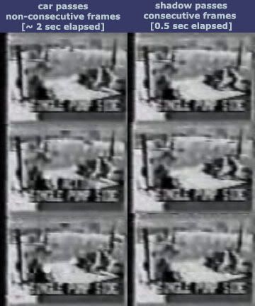
The answer Dylan provided to his question was to be seen in a short segment of the station’s security video (9:40:37-9:40:39 by video timestamp) which shows a flash of light at the northwest end of the station, and a subtle darkening of one interior camera’s field of view, as well as a less-noted soft double-pulse of light reflected off a wall on the station’s southeast end. These are usually taken as a glint from a plane on the south side of the Citgo and the shadow of same falling over the station. Though Avery failed to elaborate on what exactly the video shows, an endlessly-looping 3-second animated gif was left up to drive the vague point home. [1]
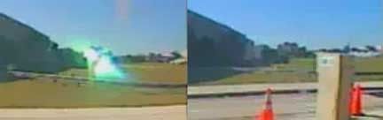
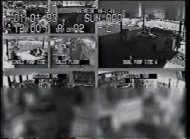 A frame of video showing the canopy flash (upper right large screen, camera 3, 'dual pump') and south end light pulse (top center small, camera 2, 'east entrance'). The interior 'shadow' was captured by camera 7, 'register 2,' lower right.
The thread is a fascinating and frustrating read, with the video’s authenticity immediately questioned by CIT cohorts Aldo Marquis and Craig Ranke and their forum compatriots, primarily via the “proven” manipulation of the video to remove key frames (a point we’ll return to at the end), and the timing of its release last year to “discredit” their then-new north path witness Robert Turcios by editing him out. At any rate, even looking at the content, a lot of doubts were aired in that thread that seriously question Avery's original 'findings.'
Rob Balsamo popped in to ask “the dim of the lower right cam for one frame is what is being argued here? Really?" It was. His piloty opinion, echoed by others, was that "that dimming effect in the lower right cam is not a "shadow" of AA77 or any other aircraft.” [2] Craig concluded “the content of the data isn't anywhere close to definitive in regards to whether or not a plane flew on the north or south side. No "fakery" at all was necessary because of this,” he announced, but was willing to entertain “low level fakery of a slight dimming in ONE view or what might appear to be a reflection or two.” [3] Researcher John Farmer (spcengineer), alongside his flaying CIT for their dishonesty, abuse of his work, and ‘delusions of grandeur,’ agreed “I do see evidence for the north side claim. I also see evidence of the south side claim […] there is not enough evidence to be dogmatic about either.” [4] Discussion of light angles was inconclusive, but enough to question the path they evidenced. After the original post, there was no defense or explanation from Dylan, despite some pleas for clarification. The poor quality video, endlessly hammered charges of alteration and irrelevance won the days, with CIT supporters slapping down grinning emoticons like silver dollars at happy hour.
I agree with these general findings that the effects captured in this loop in fact do NOT contradict the north side claim. The interior ‘shadow’ captured in camera 7 (Register Two, lower right) happens synchronous with the two lighting effects – uniform in nature and effecting one camera only, my best guess is it’s a brightness adjustment triggered by the flashes, and not a shadow cast by an airborne object. Immediate reaction of customers/employees inside and the black police car just after it sends the flash onto the canopy indicate these light bursts are at the moment of impact, not of the earlier pass over the station. This would put any plane reflection at or very near impact – so despite what I’ve published before, it may tell us tells nothing about north or south path, as both converge at that point. These light effects will require additional analysis and are beyond the scope of this piece, but the main reason I’ve identified them with impact will be fairly clear by article’s end.
The Real Shadow
Ironically, the best clue mitigating against the north-side claim in the Citgo video is one little feature Avery’s loop missed - seen onscreen just before the loop starts, at 9:40:35. Here is a video I made to help illustrate (please note this has editing effects and is less-than-clear: Do NOT use this video for in-depth research):
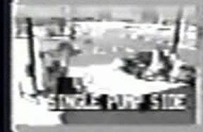 Here is the highest resolution still of that one frame I could find, provided by Farmer, who also helped me first locate the dots. This is still not very good by any measure, but briefly a large shadow – or set of shadows – appears on and then flickers away from the ground south of the station. This is the view captured by camera 4, labeled “Single Pump side,” multiplexed into the video screen above as a very small view. It was set beneath the canopy at the east edge of the southwest end of the station, looking southwest. Interestingly, this is the same camera view Robert Turcios is said to have been edited out from. Just beneath the canopy edge across the right half of the view are two large patches of darkness stretched across on the white background that seems to be the surface of South Joyce Street.
 The only early mention of this in Dylan's thread was made my Aldo: “A ways back, I noticed a couple of dots that pop up in the street in the south side camera. John Farmer points this out as well. It is inconclusive and could actually just be a flaw in the video.” [5] He'd better hope so, because the object(s) casting such a shadow would be further southeast of that in the sunlight at that time and location – in fact, roughly in the space Flight 77 is said to have passed through at about that time in the official story.
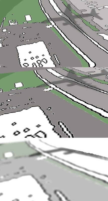
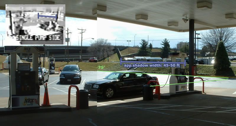 The first thing to establish is the size and location of this area of shadows. The fisheye effect of the lens clearly a factor, but not one I feel impacts the general findings, so I’ve essentially ignored it. In this montage of two site photographs kindly provided by John Farmer – taken on his research trip there earlier this year – exact feature correlation is hard to pin down. The security camera was set higher than this and looking more down, but at about this lateral angle. Using the 100 ft scale from Google maps, I measured the south parking lot at about 75 feet long and therefore the area occupied by shadow seems at least 45-50 feet across.
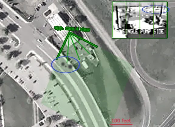
Subdividing the camera's view in 4 for reference, and approximating its field of view on a satelite map oriented north, I have placed the shadow here, on South Joyce Street:
Timeline Clues
Each camera captured in the multiplexed video has an “action” setting that seems to increase frame rate when it detects a certain level of motion. This mode is off for camera 4 as the shadow passes, so it is only visible for one frame. My non-expert analysis with iMovie shows this image holds for 10 frames of standard video (at 30 fps), so the original video would have been 3 frames per second. A plane traveling at a reported 530 mph would cross 777 feet per second, or about 260 feet per video frame – therefore we should expect just one frame to capture any meaningful part of it passing over this patch of ground.
 Vehicles passing down the street seen at other points in the video come from a great distance and take something like 60 frames or about 2 seconds to pass off-screen. The shadow, however, takes one frame to be gone, indicating that it was either crossing the road - not running down it - or moving at tremendous speed, or both.
Even more interesting is what happens after the shadow blinks off-screen again. The flashes of light and the interior ‘shadow’ featured in Avery’s loop, by my analysis (using iMovie), start happening 65 frames after the shadow first appears – 2.167 seconds, yielding a speed of around 530 mph, or just what the flight data recorded found inside the Pentagon says. I will explain this more fully below, but so far it seems this is lining up quite well with the ‘official story,’ whatever exactly that means.
Two Smudges Ain’t a 757 Shadow
The first obvious problem for this line of reasoning is ‘the shadow’ appearing as two separate dots and entirely too small to represent the outline of a 125-foot-wide 757, and far too short as well. As LCF member Avenger argued when I brought up my first awareness of the issue in Avery’s thread (link at top, page 13) “two little spots can not be the shadow of a 757,” he said. “For one thing, they are too small, and for another, there are TWO OF THEM!!!” [6]
Would it be a cop out to suggest optical effects? Factors at work to counter a clear view of the shadow include edge fuzzing due to altitude and refraction, road reflectivity, angle of view and surface topography, camera resolution, transfer resolution, and of course the shape of the object casting the shadow, in this case supposedly a twin-engine airliner. Farmer seems comfortable referring to them a single shadow and told me regarding its appearance:
”A lot of it has to do with image quality and poor quality CCD... That is the big problem, people try to see more than the system is capable of revealing. Alone the dark "smudges" mean nothing. Together with angle of sun, predicted location and altitude of plane, and other factors combine to identify it as a shadow (exactly where models predict it should be). Alone, it is just a smudge...” [7]
I've found two photos that help us understand what would be seen in this video if a 757 passed over South Joyce Street in front of the camera. I'm not allowed to repost them, or apparently to even link directly. But if you right-click this link and search for ["Mark Wilson" shadow air] you can view them. They both show a different angle relative to the camera and probably different model craft. Note the angles of the wings and engines, and the effects of minor topography; in the second picture, the slight rise of the roadway seems to have snubbed off the nose of the plane.
 And here is a perspective model I made with a 757 shadow to scale. Note also how in the foremost section the fuselage shadow and engine shadows, if divided from the rest, would appear as three separate shadows, one of which disappears once distorted along the lines of the video view, the parts at the top hidden by perspective, the lens, and the canopy (bottom).
 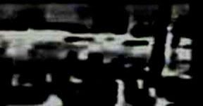 Extreme contrast reveals all the clues this crappy video has to offer as latent mid-tones pop out more sharp. It seems part of the shadow may also appear on the far right, on the other side of the support pole – If this is so, then we have big dot – small dot – big dot – line. Note that the left spot extends further towards the station’s sunken parking lot, and seems warped in shape, possibly from its interaction with the raised sidewalk, obscuring its true length on the roadway behind that.
 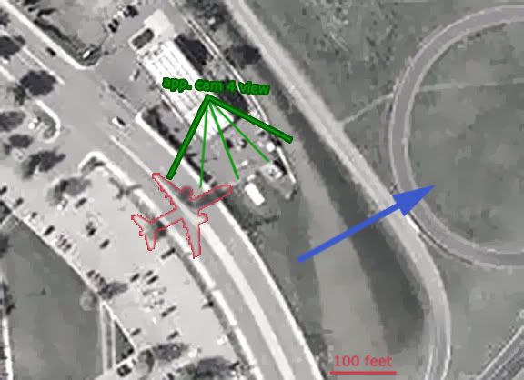 The blue arrow in this graphic shows not only the direction but also the rough location of the “official” flight path. I re-did the shadows here, elongating the southern one to flesh out what I wanted to see and to reflect the likely sidewalk effect noted above. In this scheme, big dot – small dot – big dot – line – becomes fuselage – wing root - engine - wing edge of a plane on a heading of about 60 degrees. I’m entirely open to suggestions that I’ve read this wrong, but as far as I can see this is a good overall fit.
 ---
Update 11/13:
Here is yet another rendering closer to what the camera would see, (it's tricky making perspective models with 2D image editing software).
I do realize by my fusealge-engine-60 degrees interpretation, part of the nosecone shadow would extend past the sidewalk and onto either the south edge of the parking lot or, more likely, onto the grass beyonfd that. This is a problem for this interpretation, as no such extension of the shadow is visible in the video. Keep in mind then reading the rest that shadow shape, as revealed in the video, is the weak point for this construct. It's the shadow itself, its location and timing and general size, not its apparent shape, that is most telling.
---
Having possibly explained the ‘two dots’ as two of a 757’s three leading prongs, the absence of everything else also needs to be explained. This is more tricky, but my best guess is that only the shadow falling on the darker roadway came through, while everything on or behind the narrower, lighter-colored median (see above) is effectively invisible. Supporting this possibility is how the visible shadows line up fairly well with a cut-off line at the median curve, and that the median appears nearer the top edge of the video frame; its foreshortening and fisheye distortion are worse. It seeems feasable that some combination of optical effects has left everything from there back invisible on the video even though it was there in real life.
Solar Geometry: Location and Altitude
Regardless of how exactly it came out looking, the best evidence for this being from Flight 77 is what the sun can tell us about its location. Here are the sun angles for 9/11/01 at the Capital, verified with this this solar calculator.
 Azimuth is the direction to the sun measured in degrees from north. Azimuth change from sunrise (84° or just from the north of due east) to solar noon is 96° in 379 minutes, an average change of about .25 degrees/min. Presuming steady change between these, a mid-point of 132° would be reached at 9:57 am, and it would be at 126° at 9:38. However, the change is not steady and linear but follows a curve, and in this case reaches an azimuth of 113° by the official impact time of 9:38.
 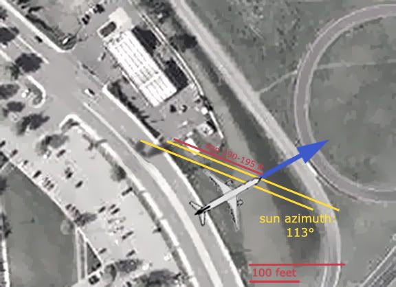 The plane placement here is based on the mechanical damage path, and verified by the black box magnetic heading (60.0°) and ground track true (61.2°) averaged and traced back from impact. I drew the sun angle from the shadow location to points intersecting that flight path and there is where I placed the plane at the moment that shadow was recorded. The dots actually appear slightly offset on the road, matching the wing axis at this heading. The shadow seems to be about 190-195 feet from corollary spots directly beneath the plane (all approximate). From this and sun altitude angle we can deduce the plane’s altitude.
 Solar altitude (also called elevation) is the angle of solar rays relative to the horizon (0 at sunrise and sunset, highest at solar noon, 55.5° at 1:05 pm at the Pentagon). On its curving path, at 9:38 the sun would have reached past its mid-point from sunrise to high solar noon, beaming down at about 32°.
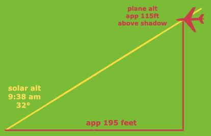 The distance from shadow mid-point to a corollary spot directly beneath the plane being about 195 feet, a vertical line beneath the plane the right height to cast a shadow that far away happens to be something like 115 feet higher than the shadow, perhaps 105 feet above ground level, which seems to be several feet higher under the plane than under the shadow. The area has a general altitude of 50-65 feet above sea level compared to about 30 at the Pentagon.
 Speed and Pitch: More Math and a Slight Problem
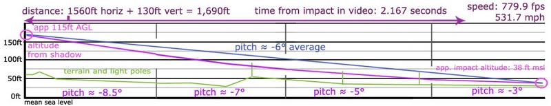
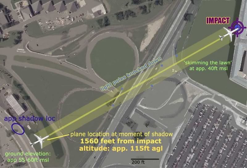 The distance from shadow-casting position to impact point, measured again, looks like almost exactly 1560 feet. With something like 130 feet descended as well, I’ve used a total distance of 1,690 feet.
 Speed – 530 mi/hr = 777.3 ft/sec
1690ft / 777.3 ft/sec = 2.174 seconds
Compare this to the 2.167 seconds between the shadow’s appearance in the video and the first light effects on the building.
Working the other way back, we get
1690 / x = 2.167 -- x = 779.88 ft/sec = 531.7 mi/hr
Compare this to the ‘official speed’ of 530 mph.
So that's a perfect fit, and next we’ll look in greater detail at pitch, or ascent/descent angle; a level plane has a pitch of 0 degrees, while nose down pitches are recorded in degrees minus. From its altitude of 115ft AGL just south of the station, a required average pitch of about -6° would be required to reach impact altitude. A steady descent at that pitch would not allow the plane to hit all the light poles as happened, so changes of angle would be required. If it was descending at roughly –8.5° as the shadow was cast, leveling to –7° and to about –6 one second later, and over the next second passing through -5° and finally settling on –3° as it crossed the lawn and knocked down the last pole, this yields a 2.5° change and one of 3 degrees in the two seconds before impact. As seen below, it doesn’t look insane or anything, but we must remember the plane would have been moving quite fast and this distance and all this change covered in a hair over two seconds.
 (r-click, open in new window for larger view)
How plausible is this steep-then-shallow pitch playing out this fast? When I’d mentioned a shallower change rate than this, Rob Balsamo told me it would rip the plane’s wings off. 8.5° is a steeper than usual pitch angle, and this overall curve is in fact extreme by my cursory look at pitch readings recorded in the FDR.
So I looked closer at the period of final descent seen in the CSV file, about 9:20 till last numbers. For the first ten minutes of this, pitches between –4 and +4 predominate, mostly at fairly mild angles of between 1 and 2 degrees from level. Pitch changes during most of that period are also subtle, fractions of a degree, with 0.0-0.2 deg/sec prevailing. This steadiness and moderation of angles begins to break up noticeably around 9:33 as the plane nears the ground, with second-to-second changes of 0.5, 0.7, 0.9° and higher creeping in. The pitch activity is fairly steady then during the grand right hand loop from 9:34-36 after which larger shifts of 1.2, 1.4, and higher become more common along with more extreme pitches like 6, 7, even 9° degrees from level recorded. The single largest one-second change I located was at 9:37:19-9:37:20, where a 2.1° decrease follows immediately after a 0.9° increase in pitch (-2.5 –1.6 –3.7 –4.9).
So by previous trends the required actual pitch changes required for that shadow to be real and properly located in my analysis - 2-3 degrees per second - seems extreme and unprecedented – just more so than the frames before, and just less so than the impact that followed. And what might seem a troublesome pitch forecast for my overall case, considering the slight fudge factor inherent in placing both the shadow and the flight path above, and that previous readings prove at least 2.1 degrees is possible, this curve doesn’t seem at all to be off in the realm of “Bush lie” sc-fi. The fudge factor of this ballpark approach could shift the numbers closer to or further from the ‘official story,’ depending, but not by a very large factor. We’re looking at an extreme but quite possible curve here.
It’s true no such changes are not reflected in the final recorded seconds of FDR data, 9:37:40-9:37:44, which shows angles between 4.9 and 6.7 degrees minus, and changes of 0.9 or less. Of course it also shows the wrong altitude and wrong bank angle for the wings to fit the above profile. But some clues, like location recorded in the L3 file 'readout 2', and John Farmer’s comparative analysis of FDR and radar records [PDF link] place it nearly a mile short of the building as those pitch numbers were recorded, so this could in fact have happened after that unexplained truncation. (This is its own whole fascinating and troubling issue far beyond the scope of this piece). Judging by much evidence, there’s a good chance it did just that, and was pitching at an average of -6° between this shadow and the final video captured at the Pentagon showing it low and fairly level from about the location of the last light pole.
Conclusion: Valid Evidence?
Charges or hints of image manipulation started from the CIT end as soon as the Citgo video was first released last September. They have no problem asserting Turcios was edited out from this same frame to weaken his testimony, but Craig has been strangely reticent to address this shadow which had to be inserted into this same camera view by his theory. Instead he’s taken to writing off the video entirely and forfeiting the chance to analyze this twice-over fakery more closely.
Their case for this dismissal rests largely on others having ‘proven’ the video altered via key cameras views not included in the final video when they were apparently on the original tape, and the cameras themselves being phyisically removed. This take is attested by the station’s manager, the same one who offered up Turcios, and taken, as Craig explained in his ATS ‘thread,’ as “Proof The Citgo Security Video Was Manipulated.” The findings of Russell Pickering, John Farmer, and CIT ally ‘Interpol’ are said to support this finding, though Farmer and Pickering have both lodged complaints with CIT, both during the course of Dylan’s thread, for using their findings to imply this.
So it appears that Aldo and Craig are in a fairly lonely spot in believing this, and rather than using the evidence for anything, they’ve declared the data irrelevant. As Craig explained to me when I brought this shadow work up at Above Top Secret, “no legitimate investigator would accept data controlled and provided for solely by the suspect as valid evidence in support of the suspect's innocence.” [8]
The finer points of this argument are too much to address in detail, and I’ve not had the time to dig into the issues, so I’ll remain agnostic for now on how much of a case there is to be made for manipulation. Likewise I leave it up to the reader to decide whether or not these possibilities render the data totally invalid or make it something that should be looked at as it is, in its proper, somewhat ambiguous context. Whether real or inserted, it seems to show Flight 77, or whatever plane we’ve been calling that, the one that pierced deep into the Pentagon two seconds later.
And however likely this shadow being inserted truly is, it appears that Aldo and Craig must continue to argue it’s either unreal or irrelevant, because if it’s authentic, this single camera’s view clearly and fatally contradicts their witnesses’ north-of-the-Citgo testimony. If true, that would leave the only question as HOW these erred recollections managed to line up so on something consistently contradicted at every other turn.
So considering we don’t know if this shadow was actually recorded or airbrushed in later, Avery's original question of why the video counters the PentaCon must be left open. The real question should have been how exactly it does so, but this was not explained until I popped into the thread on page 13 nearly two months after Dylan’s first and last post. I hope this analysis sheds some light on how the video actually does contradict the claim, just one more point in an already imposing roster of clues that should leave any rational person, at the lest, doubting CIT’s claims that their overall case is ‘proven’ in any way.
---
Above Top Secret Thread - more discussion
9/11 Blogger post with interesting comments
---
Updates 6/25/08 The case for video dismissal is weaker than I thought. Video on the way, using slightly different numbers - altitude above shadow now appears about 105 feet, under 100 AGL. It's all approximate.
---
Sources:
[1] “Why does the Citgo video contradict the North Side claim?” Loose Change Forum -> 9/11 Research -> The Pentagon. Posted by Dylan Avery August 9 2007, 02:21 PM.
http://z10.invisionfree.com/Loose_Change_Forum/index.php?showtopic=13548&st=0
[2] See [1].Posted by Pilots For 9/11 Truth. Aug 10 2007, 01:32 PM. http://z10.invisionfree.com/Loose_Change_Forum/index.php?showtopic=13548&st=20
[3] See [1]. Page 5. Craig Ranke CIT. Posted Aug 11 2007, 01:39 AM.
[4] See [2]. Page 10. Spcengineer. Posted Aug 14 2007, 02:51 PM
[5] See [1]. Page 2. Aldo Marquis CIT. Posted August 10 2007, 01:23 PM
[6] See [1]. Page 15. Posted by Avenger October 5 2007, 06:35 PM http://z10.invisionfree.com/Loose_Change_Forum/index.php?showtopic=13548&st=280
[7] E-mail from Farmer to me: Wed, 10 Oct 2007 15:52:01
[8] Above Top Secret.com -> 9/11 Conspiracies -> Flight 77’s Shadow?.-> Page 5. Post by Craig Ranke CIT. Posted October 29 2007 @ 11:04 PM. http://www.abovetopsecret.com/forum/thread311324/pg5


7 comments:
re: the altitude and azimuth of the sun. Why did you use the linear approximation when calculating sun's position, when there are many online calculators or even free software, where you can get more accurate values?
This is the position of the sun on 9/11 at 9:38 for Washington, time zone GMT -4.
AZ: 113°
ALT: 32°
Can you also expand on the trigonometry used to calculate the shadow offset? I just can't reproduce an altitude of 72ft from an angle of 25°and 165ft initial shadow offset. 72ft tall stick would only cast a 154ft shadow, when the sun was at 25°. Or the stick would have to be 77ft tall to cast a 165ft shadow. That's a 5 foot difference.
Yet using real values for sun ALT, the stick would have to be 103ft tall to cast a 165ft shadow. That's 31 feet more than your calculations.
Smaller azimuth actually brings the plane closer to the Pentagon, leaving it even less time to lose those additional 31 feet of altitude to crash into the building and especially the light poles.
On a closer look, you also got those 165ft from a measurement, also dependant on the sun's azimuth. The actual altitude of the plane, using your position of the shadow and your direction of its flight path, would be 113 feet. Can your plane loose that much to still crash into the light poles?
I didn't find a calculator and wanted the full data set to work with - sunrise, sunset, solar noon altitude... no bias. I was not able to calculate which numbers would make this work better, just looking for the best math. I did presume steady change which might've thrown it off.
Is it wrong? 113 and 126 are significantly off, as is 32 compared to 25. Hmmm... thanks for the tips, I will have to look into this math a bit. 103 feet AGL is a bit high to fit the model, but still plausible...
Re 72 ft vs 77 foot height, that was approximate. I don't even know the formula, just measured the sides comp. to the ruler in Photoshop. So I put 'app.' next to it. If the real height would be 77, then I'm pretty close. Also the shadow placement AND plane placement are somewhat rough as well, so this is all a bit approximate. IF I'm working with the right angle numbers.
If I'm wrong, we're still in a range of possibility, but perhaps getting more iffy... Care to share a link to your calculator? I'll go find my own and compare.
Thanks for the tips, relevant poster with irrelevant name.
In summary:
Shadow is found right where it is expected to be. At the right time. At the right location. If this was just an anomaly, it would be a miraculously coincidental one. On the other hand:
“no legitimate investigator would accept data controlled and provided for solely by the suspect as valid evidence in support of the suspect's innocence.”
Listening to CIT is great comedy as usual.
Why would the 9/11 perpetrators fake a shadow hidden away in a video frame when they could simply leave it out, just as they could have left the light poles intact on the nearby highway? Why would Dick Cheney go through the effort of coordinating unprecedented war game scenarios to enable a normally impossible and spectacular plane-into-building psyop attack without following through with the same at the Pentagon?
For the purpose of flying a plane over a building? In front of early morning traffic jams? Why? Do people actually believe this?
http://www.geocities.com/senol_gulgonul/sun/
http://susdesign.com/sunangle/
http://www.learn.londonmet.ac.uk/packages/daymedia/axel/sky/sunpath_calc.html
That's just from the top of google search. For free 3D real-time planetarium software check out Celestia or Stellarium. On the commercial side I've always liked Starry Night.
Whatever you choose to use, make sure to account for the daylight saving time.
Also read up on measurement errors and how they affect the final result. Balsamo and his band of Merry "Pilots" don't grasp the concept, you appear to be following them.
If there's an uncertainty of 40 feet in your plane altitude measurements/calculations, your neat trajectory plot for the last seconds doesn't look so neat anymore. In fact, if the plane has to lose additional 40 feet of altitude by the time it hits the first light pole, what's stopping it from crashing straight onto that overpass?
Irelevant said..
"Balsamo and his band of Merry "Pilots" don't grasp the concept, you appear to be following them."
Following those clowns? Ouch, that's cold dawg.
Thank you for saving my ass from going any further on flawed numbers. My error was in assuming constant change - it's a curve, not linear, sine wave, not triangle. Of course. Thanks for the links - I used this one:
http://www2.arnes.si/~gljsentvid10/nebes_pod/legasonca.html
and found the same numbers you did - 113 and 32. I also sampled other times and analyzed trends - varying deg/min changes, fascinating but not really needed I guess.
This changes nothing really for location/speed, but of course distance to shadow is incresed and AGL alt doubly-bumped up. It is a problem, as 2deg pitch change in 2 sec was already kinda steep.
I will update all ASAP and note any relevant changes to my findings and fit.
Other than the finer math however, and barring in any major irreconcilable pitch findings, the findings in general stand.
arabesque said...
"In summary:
Shadow is found right where it is expected to be. At the right time. At the right location. If this was just an anomaly, it would be a miraculously coincidental one."
Which is why the possibility barely crossed my mind. In all probability, it's gotta be either real or memorex.
"On the other hand: “no legitimate investigator would accept data controlled and provided for solely by the suspect as valid evidence in support of the suspect's innocence.”
Listening to CIT is great comedy as usual."
Especially considering guilt or innocence of the 'suspects' is not even the issue. I'm only arguing their innocence of this flyover fantasy, and with plenty of good reason. Craig does not like to admit this distinction - I'm just plain on their side now (if unwittingly, blah blah).
"Why would the 9/11 perpetrators fake a shadow hidden away in a video frame when they could simply leave it out, just as they could have left the light poles intact on the nearby highway? Why would Dick Cheney go through the effort of coordinating unprecedented war game scenarios to enable a normally impossible and spectacular plane-into-building psyop attack without following through with the same at the Pentagon?
For the purpose of flying a plane over a building? In front of early morning traffic jams? Why?"
Good question. This shadow psyop hasn't even been noticed yet anyway - they may as well have left it out.
"Do people actually believe this?"
A few, I'm sure. Certain 'bots' and errand boys are programmed to believe it, and they just talk loud. Just remember the population of these forums and stuff does NOT reflect reality by any measure. Please do pay attention to the man behind the curtain, and ignore the imposing plasma screen blow-up of CIT's over-amped self-importance.
Nice effort tackling the "shadow". Now for some background, I did some 3D modeling with what little was known about the flight path at this point in time. I predicted with the frame rate there was a high probability that a shadow should be seen in at least one frame segment (~9-10 frames). I could not see it in the crude YouTube version, so I found the best quality version I could (the VCR tape sent to Bingham by the FBI). The result was this "shadow" and it fit the modeling predictions.
Now, as to range of error mentioned by irelevant. He (or she) is absolutely correct. The actual position of the plane would be dependent upon altitude and vice versa. Since both of these are unknown variables at this point, the best that can be done is setting up boundaries. I used the Doubletree video and pole heights as upper/lower limits and went from there. Then you have a range of possibilities to work with (error band).
This is certainly not "conclusive", but definitely builds a stronger case for a southern approach (official path). Hopefully I will redo my work on the "flash" soon. Although it too is not conclusive, there is evidence of something airborne to the northeast of the station as well. That is how I found Craig and Aldo, looking for witnesses who might have seen something on the north side of the station to account for the "flash". Ya gotta keep limiters in mind my friend (one government agent to another).
Post a Comment