Adam Larson / Caustic Logic
The Frustrating Fraud
September 7 2007
Again with the things that've been done before.
In trying to map out the final locations of the plane recorded in the csv file, I ran up against the problem of readings measured with degrees and minutes, but not seconds. This isn’t precise enough to see how the final plots compare to the official story; at 9:36:45 for example, it was somewhere in the zone marked by N38∞49',W077∞31', something like a square mile. While seconds are not recorded, minute rollovers and heading are, so I graphed out when it crossed what lines at what angle and went from there to use timeline seconds to help get a better idea of geographical seconds.
Lat-long minute lines crossed in the last minute of flight – just as the 330 loop was finishing and the plane straightened out on a 70 heading – 9:37:45-9:37:44:
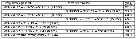
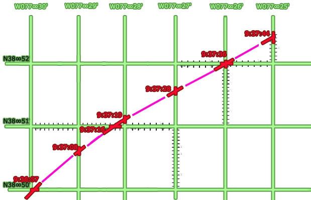
The number of seconds taken to pass a certain way is marked off on that axis, true heading (mag angles minus ten degrees) are marked at each crossing (red), with the rest of flight filled in between (magenta). In retrospect my grid is slightly uneven, giving a mild wiggle to the flight path – but all proportions, times, and locations otherwise line up – as usual not exact but close enough to see a clear and logical pattern.
Which becomes interesting when it tries to line up with real-world grid lines, mapped here with the same curve from above matched with the official final trajectory and impact point.

A literal mapping would make no sense, putting the path consistently about 20 miles off to the west via the massive longitudinal offset previously calculated at about 22 minutes (about 1/3 of a degree) – but here I took the west-offset arbitrarily as a whole-minute difference of 21' to match closest lines in the area - W077∞30' mapped over W077°09', etc. Any possible north offset was ignored, with latitude lines placed the same (38∞52' mapped as 38°52').
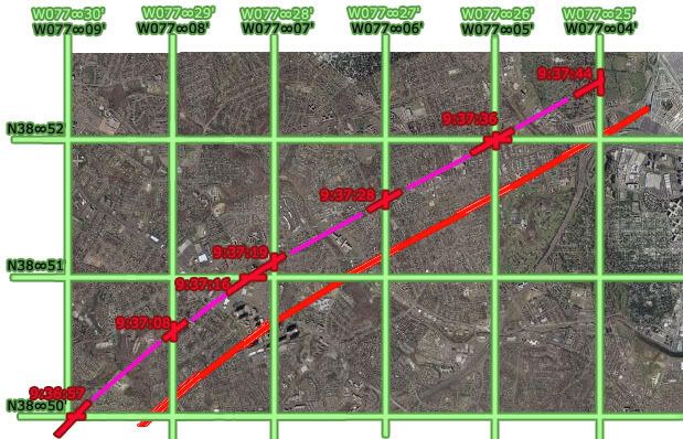
The flight paths don’t match up, evidencing a north deviation of approximately 20 seconds north of real. The west reading appears roughly on with the 21 minute offset, but on closer inspection syops a bit short. The exact end point is less clear; considering one second left from the csv's last frame 'till impact, about 3-4 seconds at current rate to reach Pentagon from 04 line, this puts the readings again around 20-25 geo seconds too far west.
Csv flight path and corresponding grid shifted to match official flight path:

The Offset is roughly square or perhaps proportionate to the rectangular parcels marked out here – about a third of a minute on each side. So the West offset is now set by me at about 21’20” West and 0’20” north.


No comments:
Post a Comment