Adam Larson / Caustic Logic
The Frustrating Fraud
rough draft, last updated 8/29 early am
The Color Track System
The tedium of mapping out the otherwise-ignored and probably irrelevant global grid beneath the plane in the NTSB animation is finally paying off, and looking at the east-west latitude lines passed or paralleled on the screen, I’ve made some interesting discoveries.
I have identified eleven latitude lines of note that frame the flight’s north-south dimensions and run along its east-west axis. I color-coded each line individually tracing it, continuously through its flight. each line is verified at multiple points as contiguous, parallel to its neighbors, and having a steady relation to the evolving flight path/ground track – in generally far more parallel than is warranted for real-world latitude lines but a general good fit for lines oriented to magnetic north.
1-blue – northernmost, never crossed
2-violet – next line south
3-purple – the most consistently paralleled line on the outbound flight.
4-magenta
5-red
6-orange
7-yellow – actually the first line crossed at the runway
8 –green
9 – aqua – the most consistently paralleled line on the outbound flight.
10 –sky blue – southernmost line actually crossed
11 – dark blue (intermittent, never crossed)
 Here are lines 4-11 as seen at 9:07:39, headed more or less east (84 magnetic at this spot). Note that here on the south side, the exact lines at or near to north half flight path are not entirely clear. Lines 2 and three are there as well but unmarked due to lack of clarity. Reading the south path from north yields similar results, but there are better views that illustrate the color continuity.
 To show how I tracked them, I’m imbedding a rudimentary “animation” of several dozen frames made in Photoshop of stills from the animation with the colored lines traced on. This is version 2, with another version or two to come before I call it good enough. The music is my own, from '99.
Initially what I saw was something like this over the full flight path:
 (new window for full size)
I think it's a bit wrong, arrived at by misreading the cross-points at the south turn slightly, and by copying the exact bend I had mapped out for line 3 (see below) for each line. But while this grid came close to explaining what the animation shows, there are some serious perspective issues at work, and the obvious point that there's no such bend visible in the onscreen "latitude lines." I'd guess a subtle curve would actually explain it better, but also started tinkering with some straight-line solutions. Straight lines visibly and logically make more sense, and are more likely correct. But compared to what's seen in the video, this one at least is off on significantly on several points.

Examples:
Yellow Track – Line 7
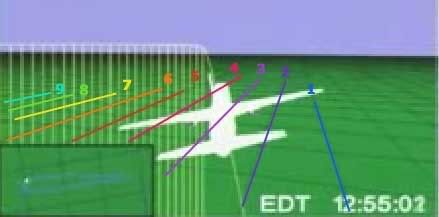
 Just to start, I’ve marked the ends of the color-coded latitude lines as the flight path turns sharply south around 8:55 am, just after the takeover. Eight of the 11 lines (lines 2-9) are crossed in this ominous maneuver roughly as mapped out below. Note where line 7 (yellow) crosses at the west end of the path, during the turn at about 8:58. Keep this location in mind as we shift attention to the other end(s) of the flight path.
 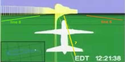 The yellow line continues down the middle of the space between the outbound and return flights. At the other end of the bent, elongated horseshoe flight path, the line still runs and is visible in both directions. Just after takeoff - 8:22 am the plane is paralleling line 7, line 8 visible to the left just north of the return flight ground track (and line 9 – aqua – is also there but not clear enough to mark), and 6 to the right. Perspective here is fierce, and the picture gets clearer as the plane gets higher.
 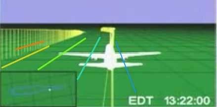 Here it is an hour later as it neared the same point; this is the bottleneck of the flight, where we can see an easier point for referencing the other side and establishing continuity. There are about 2.5 parcels marked out by three lines running between the two paths, and the angle is clear to see. If these are east-west lines, why is the plane angling to the right in both directions when it was supposed to be southwest then northeast, and should slant to the left?
 Purple Track - Line 3
In the video above, watch from frames 12:34:48 to the south turn.The red line down the center is number 5, the magenta number 4, and purple is number 3, which is interesting to follow. It first passes under flight path at about 8:36, during northward turn. Line 2 (violet) is also barely passed a minute or so later and then paralleled, though the plane remains south of line 1 (blue) the whole time. Follow the track ahead a few frames, and notice that as the plane corrects back to the south it passes near line 3, but the ground track never again touches or crosses it until the south turn at the end there.
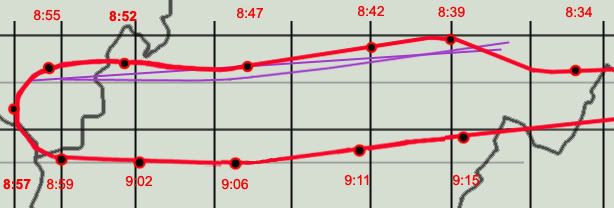 In order for this single line to both cross during the north sweep and again as it turns south, at least as I’ve plotted those points, it could not be east-west in relation to the official flight path. The most logical conclusion is that it has a slant, shown here as the straight purple line. However, the ground track does not cross over or touch this line again in the animation between these two points, as it would at 8:47 if a straight slant. In fact it almost seems to bow around that point from slanted to true east-west. This may sound strange, but compare the straight slant to the bowed line with what’s seen in the animation and tell me if this doesn’t fit better. Or is the roughness of my graphics, like the placement of 8:47 plot, enough to throw this off and insinuate a bend?
 ---
Aqua/Sky Blue Track – lines 9 and 10
Line 9, coded aqua, is the one most closely paralleled on the return flight. The third southernmost line, it’s first intersected by the ground track around9:01. Line 10 (sky blue) is to its right (south), of course also closely paralelled. Together they frame its return flight.
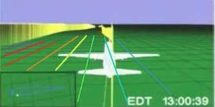 9:00:39 - just after the south turn but straightening out to head east - lines 3-10 shown here – line 9 (aqua) is just south of the ground track here, but the plane soon crosses so it’s to the north, and then evens out and parallels right over for a while. The cross-point for line 9 is further out than it seems, and is clearly not parallel here (as I said in the video - above - will be fixed in version 3).
  Despite 20 minutes travel and a recorded northward turn, line 9 is still running parallel and near the ground track, which is only slowly approaching line 10 (sky blue). Now – heading slightly northeast (mag heading 90, 80 real) – should it be trending slightly south between “latitude lines?”
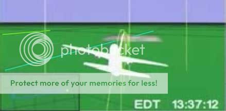
And finally tracing the lines through the final approach loop, we see that aqua line 9 is the one that crosses the Pentagon overlay map. I'm not able to match this with my path here without a final curve, but again, the red path is less than perfect (I had similar troubles matching up line 7 after takeoff). Either way, this rough intersection gives us an end point to draw a more precise track of lines 9 and 10.
 Looking for traight line solution, none seemed to work for all points. But I was able to soften the curve greatly and found the best fit, much better than my bent model above. On the whole it’s effectively straight, so I’m thinking now the lines are most likely straight but clearly slanted from reality. I keep seeing a curve if not a bend, but it's subtler than I thought,and possibly an illusion from my flight path graphics' imprecision (I have below corrected at least one small spot, placing 9:15 a few minutes further north to match the csv, which helps the straight lines fit). This graphic shows a curved version that works quite well along with the closest fit straight solution (lines slanted at about 83 degrees, seven degrees counter-clockwise from reality). Note the marginal difference.
---
To come: the final map of all lines that works best at all points then I am done with this stupid subject.
Then final grid analysis and overlay map rotation issues relative to that and then I'm really done.


2 comments:
that was just me deleting a comment I put in the wrong post. Alas no one has commented on my artistry here.
Post a Comment