July 6 2008
Update July 11
Mr. Eastman, if you're reading this:
I see you are still active on the internet, having recently contacted Ron Weick to alert him of another compilation of your post-CIT/PentaCon e-mails praising "Greg Ranke" et al... It appears this was first posted and then analyzed by debunkers here (apparently pulled since) and otherwise ignored as fruity.
God bless those San Juan Capistrano kids, eh? I understand Integrated Consultants' animation bowled you over back in August 2006 and briefly convinced you for - how many hours? - that Flight 77 really did actually knock down the poles and impact the building as all the witnesses who were there said. Luckily CIT immediately started "proving" with your star witness and two more that, even though there was no "killer" F-16, the flyover decoy plane really did pass north of the Citgo and NOT impact.
Well here - in addition to the nicely linear damage that IC worked in to explain the south-of-Citgo real flight path and impact, we have the video proof - and have for almost two years now - that places that plane right on the path to do all that. I tell you man, if that little cartoon knocked you flat, what does this do for ya?
Online Videos by Veoh.com
This a re-working of my previous post from last year. The only change is the distance to the plane (before, 195', now 175) and a resultant altitide change from 115 to 105 ft above the shadow (all approximate). It's not a big change and it's all in a general range. It all fits as well as ever - essentially, perfect.
We still have no proof that the Citgo video was manipulated in any maningful way.
ETA: Dick, I know this must be hard to take and I can imagine why you might be bitter, man. Also, thanks to my posting at JREF and Brainster/Pat Curley's re-posting at Screw Loose Change, the video is already at 390 views, pretty good for a few days with no twooferbots fluffing the numbers up. A few debunkerbots I suppose, but somehow those annoy me less. Check the comments section.
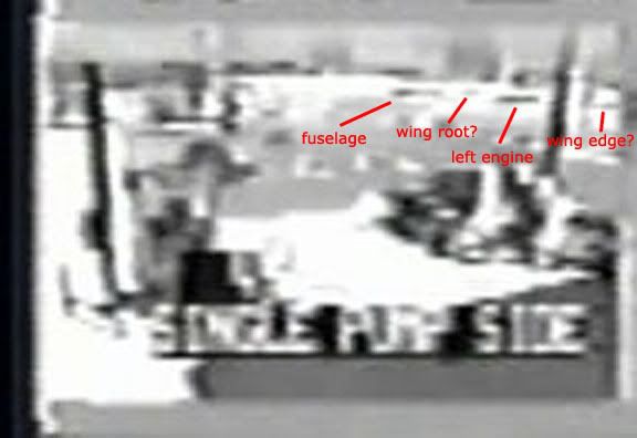
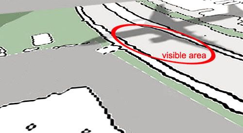
Add'l info 7/11: I've never made this clear enough, but this shadow is actually more than two dots. there's an additional small dark patch visible between them, and a faint line of shadow to the right of them. These correspond roughly to the left wing root and forward wing edge as predicted by plane shadow at the right heading. Even without seeing these, the two dots should be evident to anyone who maps out what we would see, but with these additional bits managing to come through, it becomes undeniable. If you spot any inconsistencies here in heading, do remember the aircraft may have been on a slightly different heading at that point, in a slight yaw (flying a bit sideways from its heading) and there's also the angle of view of the roadway, seen more from above in the bottom graphic and more from level in the top.


5 comments:
Re:Subject
Could you please move the comma to after the word Dick?
http://www.youtube.com/watch?v=mybWY9HJXXQ
on the comma, hah! I saw that as soon as it was posted, accidental sick wit.
On the link:
Boring! It says nothing about how the trial is coming along! But it does seem to have a number of "second plane" liars like Wheelhouse and Sucherman, but all to be trusted when they say north of stuff? I'll not be watching this. Hey, I still never saw the second plane video either! Cool! It's so liberating to fall behind on this shit.
Second Great depression likely coming soon. Better things to do (ie prepare) than to keep tangled here.
http://www.bankingtimes.co.uk/09062008-central-bank-body-warns-of-great-depression/
http://www.telegraph.co.uk/money/main.jhtml?xml=/money/2008/06/18/cnrbs118.xml
http://www.lifeaftertheoilcrash.net/Archives2008/KunstlerGrandma.html
Adam, I saw the video and is interesting. But what is the plane altitude considering the 113° azimuth and the elevation of ~15m? Did you do this calculation?
I couldn't get an exact number as all topo maps and such I've seen are too vague and my caveman trigonometry is also imprecise. I said 105' but found 115 before, so a range of 100-120' above the SHADOW. The ground beneath the plane is a bit higher. The chart in the video is roughly accurate - it would be about 160-180 msl.
That's as far as I'm taking it, anyone else can iron out the details more exact.
Post a Comment