Adam Larson / Caustic Logic
The Frustrating Fraud
August 21 2007
last updated 8/22, 1:00 pm
I had promised a piece on the grid's "latitudelines," but that one will take a little more work and could use some foreshadowing, and so here are four clues to what I'm starting to decide on...
Regarding the background grid of the NTSB's Flight 77 animation, the questions of rectangular parcel proportions and overall northern orientation are closely related. Wondering how it’s oriented may seem silly; one would presume the Safety Board’s experts, if not the FDR itself, would correct what the compass knows and show the plane on a true east-west north-south grid, with the magnetic headings showing up off from these (to almost exactly ten degrees) as they would have in real life. This does not seem to be the case.
Four clues:
1) Mini-master map:
 the full flight path is reproduced in the small window at the lower left of the animation screen and offers clues to both proportions and slope. Here is a screen cap with enhanced lines vs. official flight and real lat-long lines crossed. The animation seems to stretch the flight path over almost three squares. Undertow pointed this out to me, though I’d noticed it before, and it’s definitely a possible clue. If these mark some amalgamation of the onscreen rectangles, they should have the same proportions as those smaller parcels. That is, if a block of say 60 minutes by 60 minutes is square, a one-by-one minute unit should also be square. There is also, obviously, an angular slope evident between the two; the lower portion, again, shows the true east-west orientation of the official path, while the grid lines around the animation’s mini-map are rotated about 8-9 degrees counter-clockwise, just about consistent with magnetic north (declination 10.08 degrees).
 2) lines at 270°
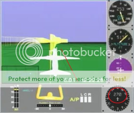 At 8:22 am the plane has a heading (nosecone orientation) of 270 degrees - due west from magnetic north, just southwest of west in true terms. It's just about parallel with the nearest latitude-looking line, and perpedicular to the longitude lines ahead. As for parcel proportions, they look fairly square here. However, perspective at this fairly low altitude of 5137 feet is fierce and makes it unclear and inconclusive.
 3) Lines at 180°
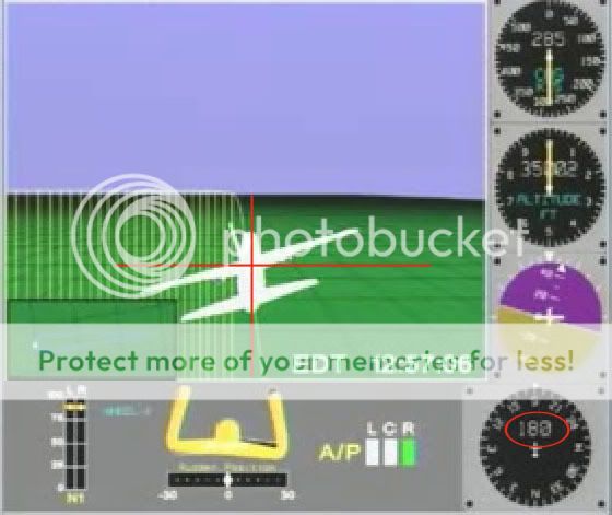 As the plane nears the mid-point of its southward turn, at 8:57, the longitude line under it shows exactly vertical, and latitudes ahead of it exactly horizontal. The heading dia shows 180, or due south. This would make perfect sense if the grid were oriented to magnetic north. These rectangles also look remarkably square seen from an elevation of over 35,000 feet, as opposed to the roughly 5:7 proportions of latitude/longitude intersections there in the real world.
 4) Lines at 70°
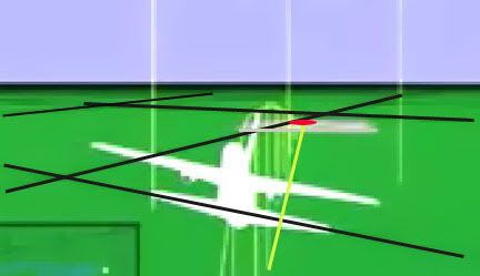 I wanted to analyze the final trajectory shown in the animation in relation to the global map, but found that harder than due west and south. To start with, here is a frame with grid lines, Pentagon location, and track (flight path along the ground) highlighted. The magnetic dial hovers right around 70° from north on this final track.
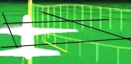
At right is another view from just before the grand loop show just where on that parcel’s west edge the ground track crosses. I figured If I marked this and de-skewed the parcel I could masure its angle of incidence.

To measure this angle for sure, I’d need to know the proportions of the rectangles, something made difficult by the foreshortened perspective. Again this looks fairly square to me, so just on a hunch I ignored real-world lines and tried de-skewing the grid there into a square. This is all a bit approximate, so don’t expect precision to more than a degree or two.
Interestingly enough, we get almost exactly 70 degrees, which is what the FDR says on that path (both in the CSV file and the animation’s heading dial). Subtracting 10 degrees for magnetic declination, we have the official trajectory of 60 that matches the physical damage.
On all four points above, the flight path reads correct in angles relative to its own internal geography, but not to real-world lines, in either placement or slope. From this, my best guess at the moment is that the animation program is pointing its longitude lines to magnetic north, and its latitudes perpendicular to that, throwing the whole grid off by a rotation of approximately ten degrees. And on top of that, it's generating a square grid map, unlike real-world lines, in which latitude lines are further apart than longitudes. This equilateral proportion indicates the flight path may've been rendered at some default equator on this globe rather than at the proper latitude. If the lines even represent latitudes and longitudes at all and not some other type of grid.
To see whether this is confirmed or denied by the latitude lines involved, I will be posting a detailed piece soon and even a short "video." In fact this is already up on Youtube and viewable at this link. Sorry for the low resolution and the choppiness of my frames. I hope it works - compare to the original animation if that helps.


No comments:
Post a Comment