DC/PENTAGON MYSTERY PLANE DISCUSSED ON CNN
Adam Larson / Caustic Logic
The Frustrating Fraud
September 26 2007
It's not brand new news, but a few weeks back, CNN aired this piece on the "9/11 Mystery plane," the large, white, 4-engine jet generally identified now as the E4-B "doomsday plane." I still haven't written anything on the issue, but it has come up time and again in my research, adding to confusion in eyewitness accounts and fertilizer to assorted theories that have come and gone. It certainly deserves a dedicated post here to add to or link to.
For additional information on this plane, see Mark Gaffney's interesting piece on this: http://www.rense.com/general76/missing.htm
Mr. Arabesque: "Pentagon Flight Path Misinformation, Stand-Down, War Games, and the Three Mysterious Planes"
Thursday, September 27, 2007


Wednesday, September 26, 2007
100 TON JETLINER FOUND AT PENTAGON!
100 TON JETLINER FOUND AT PENTAGON!
Adam Larson / Caustic Logic
The Frustrating Fraud
September 26 2007
I finally joined the Loose Change forum, hoping to take part in some of the brilliant discussions I'd read there in the past. I tried signing up as Caustic Logic, but that account wouldn't work, so I re-signed up as member “Pentagon Reality Check,” an arrogant name I instantly regretted. But ah well. It's weird times there in the Pentagon forum, with onetime moderator Craig Ranke and his cohort Aldo Marquis just banned, but their followers remain and do battle with no-planers and missile theorists apparently unmoderated but constantly badgered from the sides by those who seem to have it figured out enough to not even bother. It feels transitional.
Ayway, one ridiculous fellow member “Terral” - who is currently pushing a missile strike AND small drone strike possibly coupled with a 757 flyover - badgered me into providing some photo evidence for a 757 impact. Like a sucker faced with an aggressive panhandler, I dug into my pockets for some change and posted a few photos with a line of text for each. That's like a buck fifty right there. Time is money. The clown dismissed and ripped them apart with comically overdone no-planer brutality. In these greasy hands, anything plane-looking was planted, the photos indicated things they really did not indicate, etc. But edited to its essence, Terral said:
“Oh, the bad guys could not fit the 100-ton Jetliner in the back of their pickup truck. :0) [...] How many readers see a crashed 100-ton Jetliner in PentagonRC’s “Foundation” picture? Anybody? :0) This is nonsense . . .[...] Where did the 100-ton Jetliner go? [...] “100-Ton Jetliner” Disinformation [...] Where is your 100-ton PLANE? [...] his 100-ton Jetliner supposedly vaporized into thin air. :0) [...] little tikes do not leave 100-tons of debris [...] which proves beyond all doubt that no 100-Ton Jetliner crashed here [...] a real 100-Ton Boeing 757-200 Jetliner is [...] his 100-ton PIG [...] They are not a 100-ton Jetliner either. [...] Show us a picture of your crashed 100-ton Jetliner. :0)
Thread link
Alright no more change for this one at any rate. I did drop a final slug though with the following “photo” and caption:
 “It looks like we're both right in a way... I'm not sure where this photo is from or if its legit, but it looks like an attempted flyover, from a path well north of the Citgo, but unrelated to either the 9:32 missile attack or the small craft attack at 9:37, which caused the damage below, as you have brillinatly demonstrated. It looks here like the 757-200 jetliner is being lifted off the building with a crane, which luckily has a scale attached. I zoomed in and it says 200,000, pounds I presume. That's 100 tons on the nose. Please be at peace now Terral. Mystery solved.”
However, as my new pal had started out, “anyone in possession of these pictures, as if they prove anything, is definitely pushing the Official “Loyal Bushie” Government Cover Story.” So now I am exposed by Terral and its giant-font wielding sidekick SPreston as a 100-ton PIG hugging Bushie loyal operative with Bush goggles and accomplice to coverup and thus to mass murder. And I would have gotten away with it too, if it hadn't been for these meddling no planers, who also seem to take a bizarre pleasure in "exposing" my photo fakery and real identity! (see link above) Whatever GOP-funded computer place these guys are working at, they're brewing the coffee a wee too strong. If I were the people behind the scenes at the LC forum, I'd be checking some IPs about now. but hey, what's new?
Otherwise there is absolutely no point in this little episode. I just wanted to see a new post, and it just made me chuckle, which is kind of sad in itself.
Adam Larson / Caustic Logic
The Frustrating Fraud
September 26 2007
I finally joined the Loose Change forum, hoping to take part in some of the brilliant discussions I'd read there in the past. I tried signing up as Caustic Logic, but that account wouldn't work, so I re-signed up as member “Pentagon Reality Check,” an arrogant name I instantly regretted. But ah well. It's weird times there in the Pentagon forum, with onetime moderator Craig Ranke and his cohort Aldo Marquis just banned, but their followers remain and do battle with no-planers and missile theorists apparently unmoderated but constantly badgered from the sides by those who seem to have it figured out enough to not even bother. It feels transitional.
Ayway, one ridiculous fellow member “Terral” - who is currently pushing a missile strike AND small drone strike possibly coupled with a 757 flyover - badgered me into providing some photo evidence for a 757 impact. Like a sucker faced with an aggressive panhandler, I dug into my pockets for some change and posted a few photos with a line of text for each. That's like a buck fifty right there. Time is money. The clown dismissed and ripped them apart with comically overdone no-planer brutality. In these greasy hands, anything plane-looking was planted, the photos indicated things they really did not indicate, etc. But edited to its essence, Terral said:
“Oh, the bad guys could not fit the 100-ton Jetliner in the back of their pickup truck. :0) [...] How many readers see a crashed 100-ton Jetliner in PentagonRC’s “Foundation” picture? Anybody? :0) This is nonsense . . .[...] Where did the 100-ton Jetliner go? [...] “100-Ton Jetliner” Disinformation [...] Where is your 100-ton PLANE? [...] his 100-ton Jetliner supposedly vaporized into thin air. :0) [...] little tikes do not leave 100-tons of debris [...] which proves beyond all doubt that no 100-Ton Jetliner crashed here [...] a real 100-Ton Boeing 757-200 Jetliner is [...] his 100-ton PIG [...] They are not a 100-ton Jetliner either. [...] Show us a picture of your crashed 100-ton Jetliner. :0)
Thread link
Alright no more change for this one at any rate. I did drop a final slug though with the following “photo” and caption:
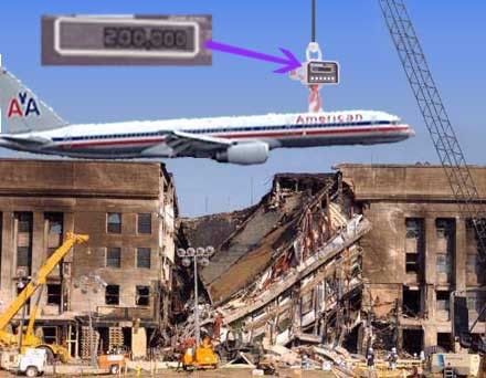 “It looks like we're both right in a way... I'm not sure where this photo is from or if its legit, but it looks like an attempted flyover, from a path well north of the Citgo, but unrelated to either the 9:32 missile attack or the small craft attack at 9:37, which caused the damage below, as you have brillinatly demonstrated. It looks here like the 757-200 jetliner is being lifted off the building with a crane, which luckily has a scale attached. I zoomed in and it says 200,000, pounds I presume. That's 100 tons on the nose. Please be at peace now Terral. Mystery solved.”
 However, as my new pal had started out, “anyone in possession of these pictures, as if they prove anything, is definitely pushing the Official “Loyal Bushie” Government Cover Story.” So now I am exposed by Terral and its giant-font wielding sidekick SPreston as a 100-ton PIG hugging Bushie loyal operative with Bush goggles and accomplice to coverup and thus to mass murder. And I would have gotten away with it too, if it hadn't been for these meddling no planers, who also seem to take a bizarre pleasure in "exposing" my photo fakery and real identity! (see link above) Whatever GOP-funded computer place these guys are working at, they're brewing the coffee a wee too strong. If I were the people behind the scenes at the LC forum, I'd be checking some IPs about now. but hey, what's new?
Otherwise there is absolutely no point in this little episode. I just wanted to see a new post, and it just made me chuckle, which is kind of sad in itself.
Monday, September 24, 2007
NTSB ANIMATION INTERNAL GEOGRAPHY {masterlist}
NTSB ANIMATION INTERNAL GEOGRAPHY {masterlist}
Adam Larson / Caustic Logic
The Frustrating Fraud
Sept. 1 2007
 This is to organize the few posts in which I have explored the internal geography - the scale and orientation of the grid beneath the plane, what seem to be latitude or longitude markers. It's not the most relevant line of inquiry, but I got interested and my analysis finalized, it's worth what it's worth.
As I started out, right off the runway I see an oddity: "the Elastic runway." (July 31) This one was pretty dumb. I let it drop as an illusion, but it is the first glimpse of the grid rotation that started popping up as I dug in.
PART 1: Ground Objects: Looking at the placement of origin (Dulles) and end (Pentagon) in relation to real-world latitude and longitude lines.
PART 2: Longitude Lines
PART 3:Grid Clues: Orienation and proportion. (August 21) Itseems square and titled as if to magnetic north.
PART 4: Latitude Color Track (with video!)
PART 5: A turn for the worse: The culmination of my mapping work here: the north-of-the-Citgo flight path from the NTSB animation is shown once and for all to be the result of rotation from the real data and no more, and all those who've promoted it as evidence are shown to be fools.

Adam Larson / Caustic Logic
The Frustrating Fraud
Sept. 1 2007
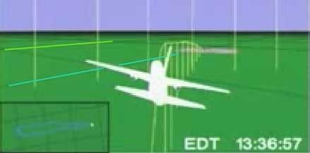 This is to organize the few posts in which I have explored the internal geography - the scale and orientation of the grid beneath the plane, what seem to be latitude or longitude markers. It's not the most relevant line of inquiry, but I got interested and my analysis finalized, it's worth what it's worth.
 As I started out, right off the runway I see an oddity: "the Elastic runway." (July 31) This one was pretty dumb. I let it drop as an illusion, but it is the first glimpse of the grid rotation that started popping up as I dug in.
PART 1: Ground Objects: Looking at the placement of origin (Dulles) and end (Pentagon) in relation to real-world latitude and longitude lines.
PART 2: Longitude Lines
PART 3:Grid Clues: Orienation and proportion. (August 21) Itseems square and titled as if to magnetic north.
PART 4: Latitude Color Track (with video!)
PART 5: A turn for the worse: The culmination of my mapping work here: the north-of-the-Citgo flight path from the NTSB animation is shown once and for all to be the result of rotation from the real data and no more, and all those who've promoted it as evidence are shown to be fools.
Friday, September 21, 2007
NTSB ANIMATION INTERNAL GEOGRAPHY PART 5
NTSB ANIMATION INTERNAL GEOGRAPHY PART 5
THE FINAL MAP: A TURN FOR THE WORSE
Adam Larson / Caustic Logic
The Frustrating Fraud
Finished Sept. 21 2007
updated 5/26/08
Very interesting thread at Above Top Secret when I posted this.
The Final Grid Analysis:
In my previous studies of the global grid beneath Flight 77 in the NTSB’s animation, I had found that the grid does not conform to real-world lines in proportion, scale, or orientation. I’m not 100% sure on the exactitudes of the final take seen below, but by multiple points of evidence it’s the best fit with what I was consistently seeing.
 This is based on extensive tracking of 11 east-west-ish “latitude” lines at multiple points in the animated flight as it crossed I think 68 apparent longitude lines. The official path shown here in red is oriented to true north, in agreement with maneuvers and time in the animation, and verified at multiple points as consistent with lat/log data from the csv file. So the red is pretty solid beyond minor variations in my graphics. The less-than-level grid seen here is also not quite straight. Straight lines just weren’t cutting it to explain all intersection points I noted, so I used slightly bowed horizontal lines. Whether or not this makes sense, the exact slant changes little over a 300-mile span; oriented about 6° CCW at the south turn (left-hand side) and ~9° CCW from due east around the Pentagon on the right.
If the curve freaks you out, let’s presume straight parallel lines, but rotated in the neighborhood of 5-10° counterclockwise from real-world latitude lines. In fact, it’s at the high-altitude south turn end that I’m least sure, and lower altitudes at takeoff and near the end make readings there more precise. So if the lines are straight, they are in the upper range, no less than 8 degrees. The overall rotation looks close to magnetic declination, which I’ve established as 10.08° counter-clockwise at that time and location. This indicates that perhaps I read some crossings wrong enough that I’m off by a few degrees and the grid was rendered with magnetic north used as north. It doesn't sound very sophisticated for the National Transportation Safety Board, but something has got these lines off-kilter.
Anyway, we now have two different orientations to consider when looking at the animation flight path – the on-screen global grid relative to true geographic heading. So let’s throw in a third level that comes into play in the animation’s final seconds and the question that got me interested in this to begin with.
The Overlay Map: Tacked-On Straight?
This started from my investigation (independently and sloppily replicating the previous works of others) of the north-path aspect of the (working copy) NTSB animation. This of course shows a final approach north of the Navy Annex and Citgo station, ruling out the physical damage path and prepping mind’s eyes to accept the PentaCon witnesses just then emerging. The animated craft is shown headed towards impact on a heading of roughly 80 degrees real relative to the ground (90 magnetic), and yet the FDR data and the heading dial on the animation itself shows a magnetic heading of 70.0, consistent with the 60° official path.
The best guess I’ve seen around is that this overlay map was simply rotated the wrong way.
For example, JREF member Apathoid, with slightly different numbers than I have, decided “the animation flight path was off 21 degrees. Since magnetic variation in the area is 10.5 degrees, its safe to assume that, in the working copy given to PfT, the NTSB simply rotated the floor map the wrong direction.”
Adding my grid findings to the picture, it seems possible that a NTSB techie was told the grid lines were set to magnetic (actually about 10.1 degrees) and be sure to rotate the map to be accurate – so they did but turned it the wrong way. An even 20-20 split makes the most sense, which makes it tempting to call my grid rotation just off enough to account for ten degrees of this, and to seek the other ten in a rotation of the map counterclockwise from these.
Here are three screen captures from the final moments that show the approaching overlay, allowing us a glimpse of a single latitude line that, thankfully, actually crosses the map. I marked its intersection with the edges with tacks, and drew the yellow lines across the map to trace the parallel across. Note that the line crosses Pentagon’s northern third, which as I’ve shown elsewhere real-world lines do not.

To analyze the content of the overlay map itself, I decided on the rough boundaries of it by analyzing the west (forward ) edge as the plane approached. I anchored this on the angle formed relative to the Navy Annex and the rough percentage of the map edge width it occupies. The back edge, and thus the scale of the map, is harder to read precisely, especially at this resolution. But I think it’s good enough; darker spots behind and to the left of the Pentagon seem to correspond to their lagoon and/or the Potomac, and some other dark shape is visible cutting the opposite corner.

I mapped real latitude and longitude lines onto a Pentagon map rotated 90° counterclockwise to mimic the approach from the west. The red map edge is placed relative to the Navy Annex to delineate the west edge. The bold black square at an offset angle thus marks my proposal for boundaries of the overlay map - I presumed a square, which looks about right and gives us the waterline spots responsible for the dark patches. Note the placement of the Pentagon and the Crystal City buildup on the right for further comparison. This is of course imprecise, but enough to get us in the neighborhood, and we can see that the yellow line is not parallel to the mapped latitude lines, meaning that the overlay map is rotated.

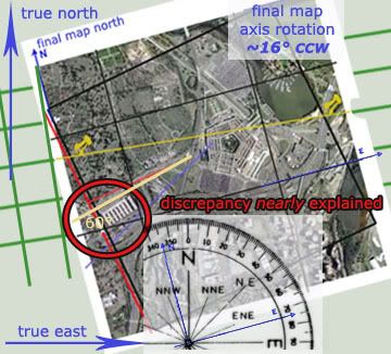
We’ve already seen the animation’s general gridlines can have no relation to real geography, but this shows the overlay map is also rotated even from the program’s own internal geography The discrepancy is not what I was hoping to see but it’s noteworthy, looking like about 7° counterclockwise. Below is a synthesis with the animation grid (in green, at proper angle but not to scale) app 9 deg ccw relative to true north and east – my final map graphic over that with tacks lined up - app 9 deg ccw + app 7 deg CCW = the final map rotated approximately ~16° CCW – from true orientation.
This double rotation, again, based on fairly accurate but imprecise analysis – seems to explain about 4/5 of the difference between the recorded heading and the onscreen ground track north of the Navy Annex and Citgo. The true official heading of 60° relative to true north is slapped on compared to the red line representing the animation path. With 80% of this explained from two different rotations, I’m left wondering if there is another twist in the data somewhere or, more likely, if I simply had enough imprecision in my graphics to throw in this large margin. That was entirely too much work for only 4/5 of an answer, but too late now.
---
update 3/31/08:
My margin just improved. Originally I worked off the FDR mag heading of 70°, a visually-mapped animation approach of 90° mag/80° real, and an animation grid rotation of ~9° CCW.
However a more exact animation approach is more like 79° real (at least one guess puts it at 76°)
FDR ground track true, more accurate than magnetic, reads 61.2°
Animation grid rotation: likely 10.08° CCW (magnetic as real north)
Final map rotation relative to global grid: still ~7° CCW
Total final map rotation from reality ~17.08° CCW
animation app. heading - established rotation = FDR heading?
79°-17.08° = 61.92°
This matches the FDR ground track true 61.2° with a margin of error I’ll call 0.72°. Not bad for an incoherent janitor, huh?
---
At any rate, I think it’s clear that both the animation lat-long grid is rotated well to counter-clockwise, and the terminal map yet further CCW from that –these two “errors” seem to be the primary reasons for the seen north path and hopefully any doubt that the map has been rotated relative to the data have been put to rest.
Conclusion: Data Set Dead
The significance of this for some cannot be ignored; as far as I can see, this double-rotation is the only thing that can be said to constitute “NTSB northern plot data” as promoted by Pilots for 9/11 Truth. It is by this “data” that other FDR evidence showing a 70(ish) magnetic heading was deemed “altered” to fit the official path marked by faked pole damage, etc. In February, Pilots co-founder and head honcho Rob Balsamo posted an e-mail exchange with “a mathmatics and statics expert in reverse engineering data.” This guy, John Farmer, explained:
“I posted a little analysis I did based on the FDR data and it suggests that my hypothetical was indeed what was done to the data. I’ve demonstrated it to my satisfaction and I’ll leave the rest in your capable hands. My guess is the simulation was done before the data alteration (that is why in the video it flies north of the Citgo station). To be honest, they really did do a sloppy job in the alteration and I would expect better from our civil servants. The guy who did the work should be fired for not doing a sanity check before releasing it.” [alternate posting not requiring a registration to read]
Rob had Farmer affirm for clarity that “the .csv file was altered in heading to match the south flight path.” Others have followed suit before and after this, since the FDR and first “Citgo witness” entered the discussion around September 2006. Aldo “Merc” Marquis, CIT co-founder and proponent of Witness/FDR northiness, said in March “I don't believe [the data] came from the Northside flyover military plane that the witnesses saw. I believe the data is faked to try and match the Northside Citgo path somewhat, for whatever reasons they chose. Either way, we win.”
Anyway, I wasn’t sure if Blsamo had wised up after people had started presuming simple rotation - so I e-mailed him the other day to clarify:
---
“Your animation includes a “transition to southern data” and the page explains you removed “NTSB northern plot data as a variable.” Before I go off on another misunderstanding then, what does the northern plot data consist of? Even after the hullabaloo I created with my stuff about the animation's map rotation being the only thing indicating this, I still have heard nothing to the contrary. I figure if there's something else in the data indicating a 80-degree-ish real trajectory at the end, you'd know and I'd like to before going to press."
---
His response was typical unapologetic Pilots boilerplate: “the map isnt rotated. We are not sure exactly how the NTSB made their plot as they are refusing to answer any questions. […] The grid on the ground correspond to lat/long lines in terms of true north and are accurate at the runway and at the pentagon/map in terms of angles/parallels. The only thing that doesnt correspond is the heading in the heading indicator at end of flight in which John Farmer did a great job locating the alterations.”
---
This is ass backwards. The grid is off in every way from real lines, the map is rotated, the NTSB clearly "plotted" their "data" with this rotation, and about the only true thing about the last moments that matches the actual data is the heading dial. He hasn’t backed down, and it seems there is no interim finding at P49T – every last crooked line is etched in stone forever.
As Russell Pickering summed up in March, “the final conclusion of PFT is obviously that the FDR data showed the south path or they would not even claim it had been altered. They had to claim it was altered since the actual aircraft data shows it on the mechanical damage path.” Oh, 1.2 degrees off they’re saying now. Whatever. There is no north plot data, and the people who promote such, to paraphrase Farmer, "should be fired for not doing a sanity check before releasing it.”
---
Update: Regarding confusion about what exactly the Pilots have argued re: north plot data and map rotation, see this post.
THE FINAL MAP: A TURN FOR THE WORSE
Adam Larson / Caustic Logic
The Frustrating Fraud
Finished Sept. 21 2007
updated 5/26/08
Very interesting thread at Above Top Secret when I posted this.
The Final Grid Analysis:
In my previous studies of the global grid beneath Flight 77 in the NTSB’s animation, I had found that the grid does not conform to real-world lines in proportion, scale, or orientation. I’m not 100% sure on the exactitudes of the final take seen below, but by multiple points of evidence it’s the best fit with what I was consistently seeing.
 This is based on extensive tracking of 11 east-west-ish “latitude” lines at multiple points in the animated flight as it crossed I think 68 apparent longitude lines. The official path shown here in red is oriented to true north, in agreement with maneuvers and time in the animation, and verified at multiple points as consistent with lat/log data from the csv file. So the red is pretty solid beyond minor variations in my graphics. The less-than-level grid seen here is also not quite straight. Straight lines just weren’t cutting it to explain all intersection points I noted, so I used slightly bowed horizontal lines. Whether or not this makes sense, the exact slant changes little over a 300-mile span; oriented about 6° CCW at the south turn (left-hand side) and ~9° CCW from due east around the Pentagon on the right.
 If the curve freaks you out, let’s presume straight parallel lines, but rotated in the neighborhood of 5-10° counterclockwise from real-world latitude lines. In fact, it’s at the high-altitude south turn end that I’m least sure, and lower altitudes at takeoff and near the end make readings there more precise. So if the lines are straight, they are in the upper range, no less than 8 degrees. The overall rotation looks close to magnetic declination, which I’ve established as 10.08° counter-clockwise at that time and location. This indicates that perhaps I read some crossings wrong enough that I’m off by a few degrees and the grid was rendered with magnetic north used as north. It doesn't sound very sophisticated for the National Transportation Safety Board, but something has got these lines off-kilter.
Anyway, we now have two different orientations to consider when looking at the animation flight path – the on-screen global grid relative to true geographic heading. So let’s throw in a third level that comes into play in the animation’s final seconds and the question that got me interested in this to begin with.
The Overlay Map: Tacked-On Straight?
This started from my investigation (independently and sloppily replicating the previous works of others) of the north-path aspect of the (working copy) NTSB animation. This of course shows a final approach north of the Navy Annex and Citgo station, ruling out the physical damage path and prepping mind’s eyes to accept the PentaCon witnesses just then emerging. The animated craft is shown headed towards impact on a heading of roughly 80 degrees real relative to the ground (90 magnetic), and yet the FDR data and the heading dial on the animation itself shows a magnetic heading of 70.0, consistent with the 60° official path.
The best guess I’ve seen around is that this overlay map was simply rotated the wrong way.
For example, JREF member Apathoid, with slightly different numbers than I have, decided “the animation flight path was off 21 degrees. Since magnetic variation in the area is 10.5 degrees, its safe to assume that, in the working copy given to PfT, the NTSB simply rotated the floor map the wrong direction.”
Adding my grid findings to the picture, it seems possible that a NTSB techie was told the grid lines were set to magnetic (actually about 10.1 degrees) and be sure to rotate the map to be accurate – so they did but turned it the wrong way. An even 20-20 split makes the most sense, which makes it tempting to call my grid rotation just off enough to account for ten degrees of this, and to seek the other ten in a rotation of the map counterclockwise from these.
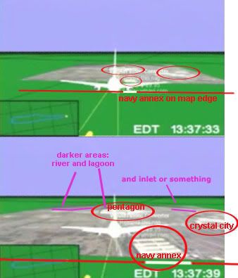
Here are three screen captures from the final moments that show the approaching overlay, allowing us a glimpse of a single latitude line that, thankfully, actually crosses the map. I marked its intersection with the edges with tacks, and drew the yellow lines across the map to trace the parallel across. Note that the line crosses Pentagon’s northern third, which as I’ve shown elsewhere real-world lines do not.
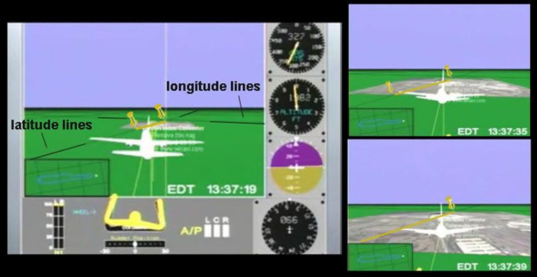
To analyze the content of the overlay map itself, I decided on the rough boundaries of it by analyzing the west (forward ) edge as the plane approached. I anchored this on the angle formed relative to the Navy Annex and the rough percentage of the map edge width it occupies. The back edge, and thus the scale of the map, is harder to read precisely, especially at this resolution. But I think it’s good enough; darker spots behind and to the left of the Pentagon seem to correspond to their lagoon and/or the Potomac, and some other dark shape is visible cutting the opposite corner.
I mapped real latitude and longitude lines onto a Pentagon map rotated 90° counterclockwise to mimic the approach from the west. The red map edge is placed relative to the Navy Annex to delineate the west edge. The bold black square at an offset angle thus marks my proposal for boundaries of the overlay map - I presumed a square, which looks about right and gives us the waterline spots responsible for the dark patches. Note the placement of the Pentagon and the Crystal City buildup on the right for further comparison. This is of course imprecise, but enough to get us in the neighborhood, and we can see that the yellow line is not parallel to the mapped latitude lines, meaning that the overlay map is rotated.
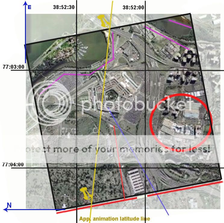
We’ve already seen the animation’s general gridlines can have no relation to real geography, but this shows the overlay map is also rotated even from the program’s own internal geography The discrepancy is not what I was hoping to see but it’s noteworthy, looking like about 7° counterclockwise. Below is a synthesis with the animation grid (in green, at proper angle but not to scale) app 9 deg ccw relative to true north and east – my final map graphic over that with tacks lined up - app 9 deg ccw + app 7 deg CCW = the final map rotated approximately ~16° CCW – from true orientation.
This double rotation, again, based on fairly accurate but imprecise analysis – seems to explain about 4/5 of the difference between the recorded heading and the onscreen ground track north of the Navy Annex and Citgo. The true official heading of 60° relative to true north is slapped on compared to the red line representing the animation path. With 80% of this explained from two different rotations, I’m left wondering if there is another twist in the data somewhere or, more likely, if I simply had enough imprecision in my graphics to throw in this large margin. That was entirely too much work for only 4/5 of an answer, but too late now.
---
update 3/31/08:
My margin just improved. Originally I worked off the FDR mag heading of 70°, a visually-mapped animation approach of 90° mag/80° real, and an animation grid rotation of ~9° CCW.
However a more exact animation approach is more like 79° real (at least one guess puts it at 76°)
FDR ground track true, more accurate than magnetic, reads 61.2°
Animation grid rotation: likely 10.08° CCW (magnetic as real north)
Final map rotation relative to global grid: still ~7° CCW
Total final map rotation from reality ~17.08° CCW
animation app. heading - established rotation = FDR heading?
79°-17.08° = 61.92°
This matches the FDR ground track true 61.2° with a margin of error I’ll call 0.72°. Not bad for an incoherent janitor, huh?
---
At any rate, I think it’s clear that both the animation lat-long grid is rotated well to counter-clockwise, and the terminal map yet further CCW from that –these two “errors” seem to be the primary reasons for the seen north path and hopefully any doubt that the map has been rotated relative to the data have been put to rest.
Conclusion: Data Set Dead
The significance of this for some cannot be ignored; as far as I can see, this double-rotation is the only thing that can be said to constitute “NTSB northern plot data” as promoted by Pilots for 9/11 Truth. It is by this “data” that other FDR evidence showing a 70(ish) magnetic heading was deemed “altered” to fit the official path marked by faked pole damage, etc. In February, Pilots co-founder and head honcho Rob Balsamo posted an e-mail exchange with “a mathmatics and statics expert in reverse engineering data.” This guy, John Farmer, explained:
“I posted a little analysis I did based on the FDR data and it suggests that my hypothetical was indeed what was done to the data. I’ve demonstrated it to my satisfaction and I’ll leave the rest in your capable hands. My guess is the simulation was done before the data alteration (that is why in the video it flies north of the Citgo station). To be honest, they really did do a sloppy job in the alteration and I would expect better from our civil servants. The guy who did the work should be fired for not doing a sanity check before releasing it.” [alternate posting not requiring a registration to read]
Rob had Farmer affirm for clarity that “the .csv file was altered in heading to match the south flight path.” Others have followed suit before and after this, since the FDR and first “Citgo witness” entered the discussion around September 2006. Aldo “Merc” Marquis, CIT co-founder and proponent of Witness/FDR northiness, said in March “I don't believe [the data] came from the Northside flyover military plane that the witnesses saw. I believe the data is faked to try and match the Northside Citgo path somewhat, for whatever reasons they chose. Either way, we win.”
Anyway, I wasn’t sure if Blsamo had wised up after people had started presuming simple rotation - so I e-mailed him the other day to clarify:
---
“Your animation includes a “transition to southern data” and the page explains you removed “NTSB northern plot data as a variable.” Before I go off on another misunderstanding then, what does the northern plot data consist of? Even after the hullabaloo I created with my stuff about the animation's map rotation being the only thing indicating this, I still have heard nothing to the contrary. I figure if there's something else in the data indicating a 80-degree-ish real trajectory at the end, you'd know and I'd like to before going to press."
---
His response was typical unapologetic Pilots boilerplate: “the map isnt rotated. We are not sure exactly how the NTSB made their plot as they are refusing to answer any questions. […] The grid on the ground correspond to lat/long lines in terms of true north and are accurate at the runway and at the pentagon/map in terms of angles/parallels. The only thing that doesnt correspond is the heading in the heading indicator at end of flight in which John Farmer did a great job locating the alterations.”
---
This is ass backwards. The grid is off in every way from real lines, the map is rotated, the NTSB clearly "plotted" their "data" with this rotation, and about the only true thing about the last moments that matches the actual data is the heading dial. He hasn’t backed down, and it seems there is no interim finding at P49T – every last crooked line is etched in stone forever.
As Russell Pickering summed up in March, “the final conclusion of PFT is obviously that the FDR data showed the south path or they would not even claim it had been altered. They had to claim it was altered since the actual aircraft data shows it on the mechanical damage path.” Oh, 1.2 degrees off they’re saying now. Whatever. There is no north plot data, and the people who promote such, to paraphrase Farmer, "should be fired for not doing a sanity check before releasing it.”
---
Update: Regarding confusion about what exactly the Pilots have argued re: north plot data and map rotation, see this post.
Saturday, September 15, 2007
REBUTTAL TO JAMES FETZER
LITMUS TEST FOR RATIONAILTY?
REBUTTAL TO JAMES FETZER
Adam Larson / Caustic Logic
The Frustrating Fraud
June 27 2007
last updated September 15 2007
A new press release boosting Pilots for 9/11 Truth as “driv[ing] another nail into a coffin of lies told the American people by The 9/11 Commission” was just released by Scholars for 9/11 Truth (the Fetzer wing). Co-founder of the recently-divided organization James Fetzer in fact seems to have written up the release, titled “New study from Pilots for 9/11 Truth: No Boeing 757 hit the Pentagon.” It was released on June 21 and picked up by Yahoo news, apparently a bit of an achievement, and has been widely republished since then. It demands a firm, well thought out response from my end, and hence the slight delay in publishing this (and the later edits and updates).
As the public decree explains, the Pilots had petitioned the National Transportation Safety Board (NTSB) under the Freedom of Information Act to receive data from the Black Box (FDR) of Flight 77. Their study of the data, Fetzer announced, “has confirmed the previous findings of Scholars for 9/11 Truth that no Boeing 757 hit the Pentagon on 9/11.” [1] I'm not sure "report" is quite the right word; it's "signed by fifteen professional pilots," so it seems to be their three-month-old March 26 Press Release, which summarized all their AA77 FDR findings. Fetzer sums their points: “the plane was too high to hit lamp posts and would have flown over the Pentagon, not impacted with its ground floor.” So it's not terribly “new,” and what’s even older is the tired list of hollow no-planer reasoning that is his group’s bolstered previous argument.
"We have had four lines of proof that no Boeing 757 hit the building,” he explained, all flawed, well-explained or seriously questioned elsewhere, and too boring to bother re-hashing in detail here; but briefly, 1) the too small hole and “the wrong […] kind and quantity of debris,” 2) the CCTV video that shows something smaller than a 757 he thinks, 3) ground effect, and 4) the unmarked lawn. These four tracks of reasoning prove to Fetzer, “conclusively, in my judgment - that no Boeing 757 hit the building.” Noting the eyewitness accounts of an AA 757 that flew by that way as the “most important evidence to the contrary,” he found that “if the NTSB data is correct, then the Pilot's study shows that a large aircraft headed toward the building but did not impact with it. It swerved off and flew above the Pentagon." [2] Just like others have been theorizing lately. How nicely it all falls together… and the Pilots don’t even have to offer a theory themselves.
Anyway…he wrote the piece with the cooperation of Rob Balsamo (John Doe X, co-founder of Pilots for 911 Truth), who explained elsewhere “Jim Fetzer and myself worked on this together.” Yet the final PR contained a major blunder… Fetzer stated that the Pilots “not only obtained the flight data but created a computer animation to demonstrate what it told them.” [3] What on Earth does that mean? I haven't seen this other animation yet, and had just been in a wrangle with Balsamo for hinting at just that possibility, contrary to their claims. Balsamo had to scramble to clarify their group “did not create the animation, which we included in "Pandora's Back Box". The NTSB provided the animation based upon its own data and spread spread sheets which can be found at our site/forums.” [4]
--
update 8/11: Recently Pilots for Truth did release an animation based on the black box data. It's pretty interesting and well done. Viewable here. Perhaps this is what Fetzer was talking about?
update 9/15: As Rob has pointed out to me, the crossed-out statement above is wrong - based on a misreading. Aplogies to have miseld with this sloppiness. They worked together on the corrections, as is obvious when I look back. In pennance, a gratis link to his unfiltered words.
--
Otherwise Fetzer carefully quotes Balasamo’s vague copy-and-paste master take on their findings: "the information in the NSTB documents does not support, and in some instances factually contradicts, the official government position that American Airlines Flight 77 struck the Pentagon on the morning of September 11, 2001." While it’s more tame than what Fetzer says, he’s not so much putting words in Balsamo’s mouth as – well, here’s another careful quote:
“Pilotsfor911truth.org does not make the claim that "No Boeing 757 hit the Pentagon". We have analyzed the Flight Data Recorder data provided by the NTSB and have shown factual analysis of that data. We do not offer theory.
While we do not make this claim in these words, the analysis we present on the basis of the NTSB's own data factually contradicts the official account that Flight 77 hit the Pentagon--if trends are continued beyond end of data records--and therefore supports the inference that American Airlines Flight 77 did not hit the building based upon that data.” [5]
In other words, they have only discovered and relayed factual government data that supports the inference that the plane would not have hit. They didn’t say it didn’t hit. They let Fetzer say it for them.
“Don't be taken in by photos showing damage to the second floor or those taken after the upper floors collapsed, which happened 20-30 minutes later," Fetzer warned, and by which I’m not sure what he means. "In fact, debris begins to show up on the completely clean lawn in short order,” and proposed this fake plane debris “might have been dropped from a C-130 that was circling above the Pentagon or placed there by men in suits who were photographed carrying debris with them." [6] Might be…
The most famous such scrap, photographed by Mark Faram, Fetzer admits “is a piece from the fuselage of a commercial airliner, which is frequently adduced as evidence,” by, for example, James Hanson of Ohio. Fetzer explains in his PR that Hanson “has traced that debris to an American Airlines 757 that crashed in a rain forest above Cali, Columbia in 1995.” Check out what this genius Hanson uses for evidence: a six-year old liana vine still embedded in the Pentagon "fuselage" metal! You have to see it to disbelieve it, so DO NOT click that link if you want to believe Hanson. Fetzer bought it though and was impressed enough with this find to offer to republish Hanson’s study on the Scholars’ site. [7]
One of the deepest ironies revealed in Fetzer’s missive is that "Fetzer [...] retired last June after 35 years of teaching courses in logic, critical thinking, and scientific reasoning.” Well, how could one argue with the logical conclusions of a renowned logic expert? I’ll try it caustically. Fact is, what this background of his shows to me is that he knows exactly what he’s doing – elevating a fraud to guiding principle of the “Truth Movement” he claims a leadership role in to arrive at the “truth.” In the end, from all this Fetzer was able to use his deep knowledge of ctical thinking and scientific deduction (as well, of course, as years learning all of their opposites – the arts of sophistry, quackery, and deception) to deduce an argument finally totally inverse to my own growing suspicions:
"The Pentagon has become a kind of litmus test for rationality in the study of 9/11. Those who persist in maintaining that a Boeing 757 hit the building are either unfamiliar with the evidence or cognitively impaired. Unless they want to mislead the American people. The evidence is beyond clear and compelling. It places this issue 'beyond a reasonable doubt'. No Boeing 757 hit the Pentagon."
I am quite familiar with the evidence, and I invite anyone to check my reasoning for soundness of judgment. That’s what this site’s about: “the hijacking of the 9/11 Truth Movement by the no-757 at the Pentagon theory." It almost feels with this salvo like Fetzer the mental “muscle hijacker” is letting us know the pilots have the cockpit; he tells us never mind the doubters, move to the back of the plane. No need to investigate for yourselves, we have it all figured out. We are returning to the airport. We just need to agree on this and move on.
But what if the Pilots intend to crash this plane? It’s happened before. That's not even a box cutter Fetzer's holding, people. It's a carbdoard prop. We can take this plane back. Let's Roll.
Sources:
[1], [2], [3], [6], [7] Fetzer, James/Scholars for 9/11 Truth. “New study from Pilots for 9/11 Truth: No Boeing 757 hit the Pentagon.” June 21 2007.
Trackback URL: http://prweb.com/pingpr.php/Q291cC1NYWduLVRoaXItQ291cC1UaGlyLVplcm8=
http://news.yahoo.com/s/prweb/20070621/bs_prweb/prweb534642_1
[4], [5] John Doe X. Official Comment/corrections. Pilots for 9/11 Truth Discussion Board. Posted Jun 23 2007, 12:36 AM. http://z9.invisionfree.com/Pilots_For_Truth/index.php?s=ec3b737719855ae19fc27c1b5a81c7b0&showtopic=7372&st=15&#entry9361808
REBUTTAL TO JAMES FETZER
Adam Larson / Caustic Logic
The Frustrating Fraud
June 27 2007
last updated September 15 2007
A new press release boosting Pilots for 9/11 Truth as “driv[ing] another nail into a coffin of lies told the American people by The 9/11 Commission” was just released by Scholars for 9/11 Truth (the Fetzer wing). Co-founder of the recently-divided organization James Fetzer in fact seems to have written up the release, titled “New study from Pilots for 9/11 Truth: No Boeing 757 hit the Pentagon.” It was released on June 21 and picked up by Yahoo news, apparently a bit of an achievement, and has been widely republished since then. It demands a firm, well thought out response from my end, and hence the slight delay in publishing this (and the later edits and updates).
As the public decree explains, the Pilots had petitioned the National Transportation Safety Board (NTSB) under the Freedom of Information Act to receive data from the Black Box (FDR) of Flight 77. Their study of the data, Fetzer announced, “has confirmed the previous findings of Scholars for 9/11 Truth that no Boeing 757 hit the Pentagon on 9/11.” [1] I'm not sure "report" is quite the right word; it's "signed by fifteen professional pilots," so it seems to be their three-month-old March 26 Press Release, which summarized all their AA77 FDR findings. Fetzer sums their points: “the plane was too high to hit lamp posts and would have flown over the Pentagon, not impacted with its ground floor.” So it's not terribly “new,” and what’s even older is the tired list of hollow no-planer reasoning that is his group’s bolstered previous argument.
"We have had four lines of proof that no Boeing 757 hit the building,” he explained, all flawed, well-explained or seriously questioned elsewhere, and too boring to bother re-hashing in detail here; but briefly, 1) the too small hole and “the wrong […] kind and quantity of debris,” 2) the CCTV video that shows something smaller than a 757 he thinks, 3) ground effect, and 4) the unmarked lawn. These four tracks of reasoning prove to Fetzer, “conclusively, in my judgment - that no Boeing 757 hit the building.” Noting the eyewitness accounts of an AA 757 that flew by that way as the “most important evidence to the contrary,” he found that “if the NTSB data is correct, then the Pilot's study shows that a large aircraft headed toward the building but did not impact with it. It swerved off and flew above the Pentagon." [2] Just like others have been theorizing lately. How nicely it all falls together… and the Pilots don’t even have to offer a theory themselves.
Anyway…
--
update 8/11: Recently Pilots for Truth did release an animation based on the black box data. It's pretty interesting and well done. Viewable here. Perhaps this is what Fetzer was talking about?
update 9/15: As Rob has pointed out to me, the crossed-out statement above is wrong - based on a misreading. Aplogies to have miseld with this sloppiness. They worked together on the corrections, as is obvious when I look back. In pennance, a gratis link to his unfiltered words.
--
Otherwise Fetzer carefully quotes Balasamo’s vague copy-and-paste master take on their findings: "the information in the NSTB documents does not support, and in some instances factually contradicts, the official government position that American Airlines Flight 77 struck the Pentagon on the morning of September 11, 2001." While it’s more tame than what Fetzer says, he’s not so much putting words in Balsamo’s mouth as – well, here’s another careful quote:
“Pilotsfor911truth.org does not make the claim that "No Boeing 757 hit the Pentagon". We have analyzed the Flight Data Recorder data provided by the NTSB and have shown factual analysis of that data. We do not offer theory.
While we do not make this claim in these words, the analysis we present on the basis of the NTSB's own data factually contradicts the official account that Flight 77 hit the Pentagon--if trends are continued beyond end of data records--and therefore supports the inference that American Airlines Flight 77 did not hit the building based upon that data.” [5]
In other words, they have only discovered and relayed factual government data that supports the inference that the plane would not have hit. They didn’t say it didn’t hit. They let Fetzer say it for them.
“Don't be taken in by photos showing damage to the second floor or those taken after the upper floors collapsed, which happened 20-30 minutes later," Fetzer warned, and by which I’m not sure what he means. "In fact, debris begins to show up on the completely clean lawn in short order,” and proposed this fake plane debris “might have been dropped from a C-130 that was circling above the Pentagon or placed there by men in suits who were photographed carrying debris with them." [6] Might be…
The most famous such scrap, photographed by Mark Faram, Fetzer admits “is a piece from the fuselage of a commercial airliner, which is frequently adduced as evidence,” by, for example, James Hanson of Ohio. Fetzer explains in his PR that Hanson “has traced that debris to an American Airlines 757 that crashed in a rain forest above Cali, Columbia in 1995.” Check out what this genius Hanson uses for evidence: a six-year old liana vine still embedded in the Pentagon "fuselage" metal! You have to see it to disbelieve it, so DO NOT click that link if you want to believe Hanson. Fetzer bought it though and was impressed enough with this find to offer to republish Hanson’s study on the Scholars’ site. [7]
 |
"The Pentagon has become a kind of litmus test for rationality in the study of 9/11. Those who persist in maintaining that a Boeing 757 hit the building are either unfamiliar with the evidence or cognitively impaired. Unless they want to mislead the American people. The evidence is beyond clear and compelling. It places this issue 'beyond a reasonable doubt'. No Boeing 757 hit the Pentagon."
I am quite familiar with the evidence, and I invite anyone to check my reasoning for soundness of judgment. That’s what this site’s about: “the hijacking of the 9/11 Truth Movement by the no-757 at the Pentagon theory." It almost feels with this salvo like Fetzer the mental “muscle hijacker” is letting us know the pilots have the cockpit; he tells us never mind the doubters, move to the back of the plane. No need to investigate for yourselves, we have it all figured out. We are returning to the airport. We just need to agree on this and move on.
But what if the Pilots intend to crash this plane? It’s happened before. That's not even a box cutter Fetzer's holding, people. It's a carbdoard prop. We can take this plane back. Let's Roll.
Sources:
[1], [2], [3], [6], [7] Fetzer, James/Scholars for 9/11 Truth. “New study from Pilots for 9/11 Truth: No Boeing 757 hit the Pentagon.” June 21 2007.
Trackback URL: http://prweb.com/pingpr.php/Q291cC1NYWduLVRoaXItQ291cC1UaGlyLVplcm8=
http://news.yahoo.com/s/prweb/20070621/bs_prweb/prweb534642_1
[4], [5] John Doe X. Official Comment/corrections. Pilots for 9/11 Truth Discussion Board. Posted Jun 23 2007, 12:36 AM. http://z9.invisionfree.com/Pilots_For_Truth/index.php?s=ec3b737719855ae19fc27c1b5a81c7b0&showtopic=7372&st=15&#entry9361808
Monday, September 10, 2007
COLUMN 9AA - WARPED BY THE LEFT WING
COLUMN 9AA - WARPED BY THE LEFT WING
Adam Larson / Caustic Logic
The Frustrating Fraud
September 10 2007
last updated 9/11 early am
In assessing the outer column damage upon impact, I had been hazy for a while on the status of column 9aa (aa meaning the outermost position on a column line). It would have been two columns over to the left (north) of the collapsed portion, and officially impacted by Flight 77’s left wing but left intact. In error I had included it as part of the columns-removed area, which I had taken as too wide. This has now been updated. Although I was focused on the right-hand side and didn’t see or wonder about this non-controversial support. It was usually listed as intact though deformed and impaired, and no-planers hadn't made any noises about it I've heard. But finally I have looked into it and found a few early (pre-shoring) photos that show it – barely. Column line 9 is roughly highlighted in each of the below to help locate it


By coincidence, these four shots rotate, zoom out, and clear-up if looked at in sequence. The first, least clear shot is pre-collapse, less than 20 min after impact, seen close and from the left and obscured by smoke. The second view is further out, just after the collapse, and somewhat clearer. The third view is off to the right from behind the smashed generator, with all up-front fire extinguished, and the final view is a long shot from the far right. Note how the curvature of the columns seems to shift with perspective – it bends to the left when seen from the left, appears straight seen straight-on, and curves to the right when seen from that side. This shape consistently indicates in inward bend.

 Column 9 is also visible in figure 9 from FEMA’s Shoring Report (above), again seen from the right, post-collapse, post-fire, but pre-shoring. It’s the “damaged column,” one of the many that necessitated the bracing that report documented. Other photos of column 9 in the report, once the wood went up, are taken head-on and show no evident lateral curve. Figure 16 (left) shows the first of the supports being finished the night after the attack, with the space to the right still left hanging.
 The close-up photo used in the American Society of Civil Engineers’s 2002 Pentagon Building Performance Report shows a column displaying “triple curvature” (shown from the right). Besides three remnants of its original square-sided casing, the angular concrete is gone, the column “stripped to spiral reinforcements.”
Regarding the evident curve, its clear inward orientation is seen elsewhere in the building with other columns, in what appears to be a bowing by Boeing. The fulcrum of appears to be in its upper portion, about 2/3 of the way up from the foundation. This is presumably the impact point of any type of wing in the area. The ASCE’s report listed the column as “5 to 6 inches out of plumb.” By the photo below, showing the column and its bend in its stabilization period environs, it seems visibly at least that misaligned at the top end in particular, further indicating a high impact.

 But this graphic used in the ASCE’s report seems to disagree, with the left engine centered just to right of column 11aa with columns 10, 9, and 8aa visible to left. In addition to there being no evidence of the left engine entering well below ground level as shown, the wing crosses low on column 9 in this mock-up, almost certainly too low to have created the bend seen above. It might seem presumptuous of me to question the ASCE's graphic placement, but it seems warranted by this evidence to venture that we have an inaccurate graphic here.
They seem to have placed the right wing correctly given the building damage at that location, but neither the left wing or engine seem marked properly. Perhaps they were trying to avoid an overly-complex explanation as to how the wings could impact at differing angles from each other, and just dropped on an intact 757's profile stretched to account for the angular impact. This is about the same reason I've done the same and am still not explicitly reconciling the wing discrepancy here. But the key to seeing how this is possible is to keep in mind that the plane impacted at such an angle that the right wing/engine and much of the fuselage were scattered inside the building by the time the left wing or tailfin ever touched the facade or outer columns. I intend to post this theory in the near future, but for now, I propose a correction like this:

My green rotation, compared to the ASCE's in red, accounts better for both the column warping seen here and for the lack of an engine burrowed six feet under the floor slab. It does seem the engine was likely low enough to have impacted the building’s foundation, if glancingly, and also possibly just high enough to have cleared the floor. This ambiguity is interesting for another study of Citizens’ Investigative Team's undamaged foundation claims by possibly making their point moot.
Adam Larson / Caustic Logic
The Frustrating Fraud
September 10 2007
last updated 9/11 early am
In assessing the outer column damage upon impact, I had been hazy for a while on the status of column 9aa (aa meaning the outermost position on a column line). It would have been two columns over to the left (north) of the collapsed portion, and officially impacted by Flight 77’s left wing but left intact. In error I had included it as part of the columns-removed area, which I had taken as too wide. This has now been updated. Although I was focused on the right-hand side and didn’t see or wonder about this non-controversial support. It was usually listed as intact though deformed and impaired, and no-planers hadn't made any noises about it I've heard. But finally I have looked into it and found a few early (pre-shoring) photos that show it – barely. Column line 9 is roughly highlighted in each of the below to help locate it


By coincidence, these four shots rotate, zoom out, and clear-up if looked at in sequence. The first, least clear shot is pre-collapse, less than 20 min after impact, seen close and from the left and obscured by smoke. The second view is further out, just after the collapse, and somewhat clearer. The third view is off to the right from behind the smashed generator, with all up-front fire extinguished, and the final view is a long shot from the far right. Note how the curvature of the columns seems to shift with perspective – it bends to the left when seen from the left, appears straight seen straight-on, and curves to the right when seen from that side. This shape consistently indicates in inward bend.

 Column 9 is also visible in figure 9 from FEMA’s Shoring Report (above), again seen from the right, post-collapse, post-fire, but pre-shoring. It’s the “damaged column,” one of the many that necessitated the bracing that report documented. Other photos of column 9 in the report, once the wood went up, are taken head-on and show no evident lateral curve. Figure 16 (left) shows the first of the supports being finished the night after the attack, with the space to the right still left hanging.
  The close-up photo used in the American Society of Civil Engineers’s 2002 Pentagon Building Performance Report shows a column displaying “triple curvature” (shown from the right). Besides three remnants of its original square-sided casing, the angular concrete is gone, the column “stripped to spiral reinforcements.”
 Regarding the evident curve, its clear inward orientation is seen elsewhere in the building with other columns, in what appears to be a bowing by Boeing. The fulcrum of appears to be in its upper portion, about 2/3 of the way up from the foundation. This is presumably the impact point of any type of wing in the area. The ASCE’s report listed the column as “5 to 6 inches out of plumb.” By the photo below, showing the column and its bend in its stabilization period environs, it seems visibly at least that misaligned at the top end in particular, further indicating a high impact.

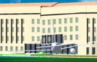 But this graphic used in the ASCE’s report seems to disagree, with the left engine centered just to right of column 11aa with columns 10, 9, and 8aa visible to left. In addition to there being no evidence of the left engine entering well below ground level as shown, the wing crosses low on column 9 in this mock-up, almost certainly too low to have created the bend seen above. It might seem presumptuous of me to question the ASCE's graphic placement, but it seems warranted by this evidence to venture that we have an inaccurate graphic here.
 They seem to have placed the right wing correctly given the building damage at that location, but neither the left wing or engine seem marked properly. Perhaps they were trying to avoid an overly-complex explanation as to how the wings could impact at differing angles from each other, and just dropped on an intact 757's profile stretched to account for the angular impact. This is about the same reason I've done the same and am still not explicitly reconciling the wing discrepancy here. But the key to seeing how this is possible is to keep in mind that the plane impacted at such an angle that the right wing/engine and much of the fuselage were scattered inside the building by the time the left wing or tailfin ever touched the facade or outer columns. I intend to post this theory in the near future, but for now, I propose a correction like this:

My green rotation, compared to the ASCE's in red, accounts better for both the column warping seen here and for the lack of an engine burrowed six feet under the floor slab. It does seem the engine was likely low enough to have impacted the building’s foundation, if glancingly, and also possibly just high enough to have cleared the floor. This ambiguity is interesting for another study of Citizens’ Investigative Team's undamaged foundation claims by possibly making their point moot.
Sunday, September 9, 2007
CITGO VIDEO ANALYSIS
CITGO VIDEO ANALYSIS
(working version posted June 28 2007)
Adam Larson / Caustic Logic
The Frustrating Fraud
Last Updated September 9 late pm

The Nexcom/Citgo gas station was the last real building near 77's flightpath before the Pentagon. Its security video was confiscated by the FBI on September 11 2001 (apparently NOT within minutes of the attack but rather a few hours later). It was held for five years and then released pursuant to FOIA requests on September 15 2006 to Judicial Watch.
The station had multiple cameras multiplexed together onto one screen. Some of the best views were NOT included in this compressed multi-camera screen. Whether this constitutes manipulation/forgery or some more inoccuous explanation I can't say for sure. But it is suspicious, and some of the cameras themselves seem to have been removed since then.
Youtube link: http://www.youtube.com/watch?v=2LJvFjsl6zk&mode=related&search= An analysis of what the remaining low-resolution screens show is in the works. Previously I'd said it showed "more nothing than anything yet," but in fact there are good clues in there. Of special interest are three camera views, mapped out on the model below.

Dual-Pump Camera and the Canopy Flash
Just looking at the view from the "dual pump side" camera (the north end of the station) we see a flash at 4:44 in the video, or 9:40:38 by the video's internal clock (app. set about 3 minutes ahead). The white car there most of the time at the pump is Sgt. Lagasse's. The sequence here: a black and white patrol car pulls in and sends the flash of light, reflected from somewhere else apparently to the south, onto the underside of the canopy, at which point the patrol car speeds away, possibly towards the Pentagon

My video - part 1 of the Citgo analysis, just the canopy flash.
Youtube link: http://www.youtube.com/watch?v=3ChV5gxYfrc#GU5U2spHI_4
Here is a photo of the station's north end - parking, hedges, canopy and pumps - with the Pentagon visible in the background. Compare to the camera view above.
Before getting to angles, I must note that some north-path proponents contend this flash is either from the plane but glancing off the car's roof, or simple sunlight reflected in a flash as the patrol car started rolling (see comments at the Youtube link for my video). It does seem to start inching forward just just a hair early - too subtly it seems to account for a sudden flash, but enough to make this interpretation seem feasible. The angle the light is coming from seems about the same as the angle of natural sunlight at that time, but a different part of the car also catches sunlight a few frames later in a different position. (I intend a fuller anlysis on the timeline of all these events). John Farmer's rebuttal and my counter-rebuttal: link.
However, as I will expand on in this space and with further short videos, there was also a noticable flash of light on the south side of the station a split-second earlier, clearly not reflected from the south side of a car on the north side of the station. There's also employee/customer reactions indicating something happening to the south, and a large shadow also visible on a roadway south of the Pentagon. These will be explained and even if the canopy flash is just sunlight, it somehow seems to show the same thing the other clues do: something other than the sun was sending light to /blocking light from the Citgo, from the south and southeast just before people started gawking towards the Pentagon. A high-speed, low-flying silver AA 757 is one possible culprit for at least one of these clues...
East Entrance (south) View and the Double Flash
 This "East Entrance" camera is at the southern edge of the southeast canopy looking back at the store to monitor customers coming and going. Note at left the lightening on the left-hand side, on the narrow east-facing edge of a wall there. This "flash" seen at 9:40:37 is longer in duration than the one off the patrol car half-a-second later, and perhaps better described as a "double-pulse." In slow-motion (video coming) there is an intial pulse just before the canopy flash, which washes in top-to-bottom and fades just as another pulse of light blankets the spot and then fades. Duration: unsure at the moment but seems to be about one second. The light source is roughlly to the east, and could be from either a plane heading from the north or the south.
Below is the video of this flash. Sorry for the glitch - it hangs up just before "slow-motion." Maybe I'll re-post it.
The Shadow
Thanks to John Farmer's interesting work, I can see the shadow now. It's visible in the south-side "Single Pump" camera, and cast on the roadway behind the station (South Joyce Street), divided in two by some invisible obstruction (possibly a median/divider). It appears at 9:40:35 (about 2 seconds before the flashes) by the video's clock and remains for about 8 frames, 1/4 of a second (though it appears stationary, apparently a still frame taken at 4 fps). All-in;all it's a large shadow. A 757 is one possibility.

I know this is crap quality to be blowing it up so big, but hey,
it's there. It can be (roughly) measured.
Youtube link: http://www.youtube.com/watch?v=hF-GcL8hR68
General Thoughts
Quotes from north path/no plane supporters: would these researchers talk about this key evidence like this if they thought it supported their theory or was irrelevant? (most from the inital Loose Change thread spurred by Russell Pickering's analysis)
John Doe X: "Talk about chasing shadows...lol." link
Aldo Marquis/Merc: "I believe the Citgo video was released SPECIFICALLY because of the Citgo witness and his account. I no longer believe this as a possibility, but as an unforunate reality. A counter chess move if you will. [...] This is a clever trick in response to the Citgo employee's account. Simply more bad video with a few editing/graphic/lighting tricks, just like the others." link
Undertow: "You know, I started to analyze that flash 4:44 (mov time) but it's just worthless in all its pixelated compressed crappyness. I don't know what anyone can possible get out of this video besides a migrane." link
(John Farmer's quote removed - I'm not so sure now he belongs on this list)
Craig Ranke (Lyte Trip): "No serious 9/11 researcher would take this video at face value. It makes zero sense." link
Craig Ranke to me: "Evidence tampering is a Federal offense and if you insist on supporting this dubious data that is supplied from the very individuals that you accuse of this crime you are just as guilty as they are." link
So naysayers aside, and all concerns of legitimacy vs. fakery taken into account (the grain of salt one must take this with), the analysis continues.
(working version posted June 28 2007)
Adam Larson / Caustic Logic
The Frustrating Fraud
Last Updated September 9 late pm
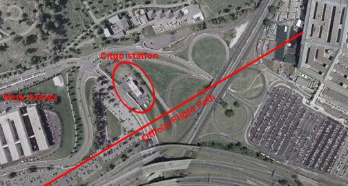
The Nexcom/Citgo gas station was the last real building near 77's flightpath before the Pentagon. Its security video was confiscated by the FBI on September 11 2001 (apparently NOT within minutes of the attack but rather a few hours later). It was held for five years and then released pursuant to FOIA requests on September 15 2006 to Judicial Watch.
The station had multiple cameras multiplexed together onto one screen. Some of the best views were NOT included in this compressed multi-camera screen. Whether this constitutes manipulation/forgery or some more inoccuous explanation I can't say for sure. But it is suspicious, and some of the cameras themselves seem to have been removed since then.
Youtube link: http://www.youtube.com/watch?v=2LJvFjsl6zk&mode=related&search= An analysis of what the remaining low-resolution screens show is in the works. Previously I'd said it showed "more nothing than anything yet," but in fact there are good clues in there. Of special interest are three camera views, mapped out on the model below.
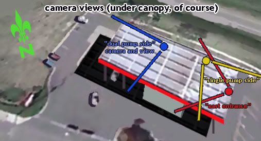
Dual-Pump Camera and the Canopy Flash
Just looking at the view from the "dual pump side" camera (the north end of the station) we see a flash at 4:44 in the video, or 9:40:38 by the video's internal clock (app. set about 3 minutes ahead). The white car there most of the time at the pump is Sgt. Lagasse's. The sequence here: a black and white patrol car pulls in and sends the flash of light, reflected from somewhere else apparently to the south, onto the underside of the canopy, at which point the patrol car speeds away, possibly towards the Pentagon
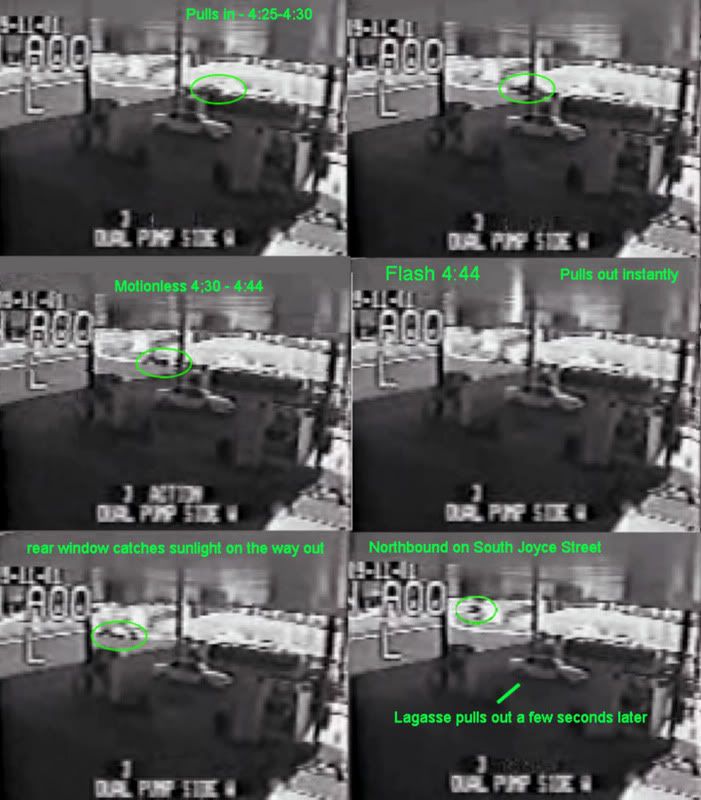
My video - part 1 of the Citgo analysis, just the canopy flash.
Youtube link: http://www.youtube.com/watch?v=3ChV5gxYfrc#GU5U2spHI_4
Here is a photo of the station's north end - parking, hedges, canopy and pumps - with the Pentagon visible in the background. Compare to the camera view above.
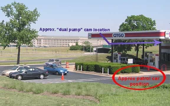
Before getting to angles, I must note that some north-path proponents contend this flash is either from the plane but glancing off the car's roof, or simple sunlight reflected in a flash as the patrol car started rolling (see comments at the Youtube link for my video). It does seem to start inching forward just just a hair early - too subtly it seems to account for a sudden flash, but enough to make this interpretation seem feasible. The angle the light is coming from seems about the same as the angle of natural sunlight at that time, but a different part of the car also catches sunlight a few frames later in a different position. (I intend a fuller anlysis on the timeline of all these events). John Farmer's rebuttal and my counter-rebuttal: link.
However, as I will expand on in this space and with further short videos, there was also a noticable flash of light on the south side of the station a split-second earlier, clearly not reflected from the south side of a car on the north side of the station. There's also employee/customer reactions indicating something happening to the south, and a large shadow also visible on a roadway south of the Pentagon. These will be explained and even if the canopy flash is just sunlight, it somehow seems to show the same thing the other clues do: something other than the sun was sending light to /blocking light from the Citgo, from the south and southeast just before people started gawking towards the Pentagon. A high-speed, low-flying silver AA 757 is one possible culprit for at least one of these clues...
East Entrance (south) View and the Double Flash
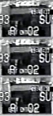 This "East Entrance" camera is at the southern edge of the southeast canopy looking back at the store to monitor customers coming and going. Note at left the lightening on the left-hand side, on the narrow east-facing edge of a wall there. This "flash" seen at 9:40:37 is longer in duration than the one off the patrol car half-a-second later, and perhaps better described as a "double-pulse." In slow-motion (video coming) there is an intial pulse just before the canopy flash, which washes in top-to-bottom and fades just as another pulse of light blankets the spot and then fades. Duration: unsure at the moment but seems to be about one second. The light source is roughlly to the east, and could be from either a plane heading from the north or the south.
 Below is the video of this flash. Sorry for the glitch - it hangs up just before "slow-motion." Maybe I'll re-post it.
The Shadow
Thanks to John Farmer's interesting work, I can see the shadow now. It's visible in the south-side "Single Pump" camera, and cast on the roadway behind the station (South Joyce Street), divided in two by some invisible obstruction (possibly a median/divider). It appears at 9:40:35 (about 2 seconds before the flashes) by the video's clock and remains for about 8 frames, 1/4 of a second (though it appears stationary, apparently a still frame taken at 4 fps). All-in;all it's a large shadow. A 757 is one possibility.
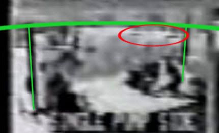
I know this is crap quality to be blowing it up so big, but hey,
it's there. It can be (roughly) measured.
Youtube link: http://www.youtube.com/watch?v=hF-GcL8hR68
General Thoughts
Quotes from north path/no plane supporters: would these researchers talk about this key evidence like this if they thought it supported their theory or was irrelevant? (most from the inital Loose Change thread spurred by Russell Pickering's analysis)
John Doe X: "Talk about chasing shadows...lol." link
Aldo Marquis/Merc: "I believe the Citgo video was released SPECIFICALLY because of the Citgo witness and his account. I no longer believe this as a possibility, but as an unforunate reality. A counter chess move if you will. [...] This is a clever trick in response to the Citgo employee's account. Simply more bad video with a few editing/graphic/lighting tricks, just like the others." link
Undertow: "You know, I started to analyze that flash 4:44 (mov time) but it's just worthless in all its pixelated compressed crappyness. I don't know what anyone can possible get out of this video besides a migrane." link
(John Farmer's quote removed - I'm not so sure now he belongs on this list)
Craig Ranke (Lyte Trip): "No serious 9/11 researcher would take this video at face value. It makes zero sense." link
Craig Ranke to me: "Evidence tampering is a Federal offense and if you insist on supporting this dubious data that is supplied from the very individuals that you accuse of this crime you are just as guilty as they are." link
So naysayers aside, and all concerns of legitimacy vs. fakery taken into account (the grain of salt one must take this with), the analysis continues.
Thursday, September 6, 2007
CSV FINAL PLOTS
CSV FINAL PLOTS AND FINDINGS
Adam Larson / Caustic Logic
The Frustrating Fraud
September 7 2007
Again with the things that've been done before.
In trying to map out the final locations of the plane recorded in the csv file, I ran up against the problem of readings measured with degrees and minutes, but not seconds. This isn’t precise enough to see how the final plots compare to the official story; at 9:36:45 for example, it was somewhere in the zone marked by N38∞49',W077∞31', something like a square mile. While seconds are not recorded, minute rollovers and heading are, so I graphed out when it crossed what lines at what angle and went from there to use timeline seconds to help get a better idea of geographical seconds.
Lat-long minute lines crossed in the last minute of flight – just as the 330 loop was finishing and the plane straightened out on a 70 heading – 9:37:45-9:37:44:


The number of seconds taken to pass a certain way is marked off on that axis, true heading (mag angles minus ten degrees) are marked at each crossing (red), with the rest of flight filled in between (magenta). In retrospect my grid is slightly uneven, giving a mild wiggle to the flight path – but all proportions, times, and locations otherwise line up – as usual not exact but close enough to see a clear and logical pattern.
Which becomes interesting when it tries to line up with real-world grid lines, mapped here with the same curve from above matched with the official final trajectory and impact point.

A literal mapping would make no sense, putting the path consistently about 20 miles off to the west via the massive longitudinal offset previously calculated at about 22 minutes (about 1/3 of a degree) – but here I took the west-offset arbitrarily as a whole-minute difference of 21' to match closest lines in the area - W077∞30' mapped over W077°09', etc. Any possible north offset was ignored, with latitude lines placed the same (38∞52' mapped as 38°52').
The flight paths don’t match up, evidencing a north deviation of approximately 20 seconds north of real. The west reading appears roughly on with the 21 minute offset, but on closer inspection syops a bit short. The exact end point is less clear; considering one second left from the csv's last frame 'till impact, about 3-4 seconds at current rate to reach Pentagon from 04 line, this puts the readings again around 20-25 geo seconds too far west.
Csv flight path and corresponding grid shifted to match official flight path:

The Offset is roughly square or perhaps proportionate to the rectangular parcels marked out here – about a third of a minute on each side. So the West offset is now set by me at about 21’20” West and 0’20” north.
Adam Larson / Caustic Logic
The Frustrating Fraud
September 7 2007
Again with the things that've been done before.
In trying to map out the final locations of the plane recorded in the csv file, I ran up against the problem of readings measured with degrees and minutes, but not seconds. This isn’t precise enough to see how the final plots compare to the official story; at 9:36:45 for example, it was somewhere in the zone marked by N38∞49',W077∞31', something like a square mile. While seconds are not recorded, minute rollovers and heading are, so I graphed out when it crossed what lines at what angle and went from there to use timeline seconds to help get a better idea of geographical seconds.
Lat-long minute lines crossed in the last minute of flight – just as the 330 loop was finishing and the plane straightened out on a 70 heading – 9:37:45-9:37:44:
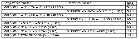
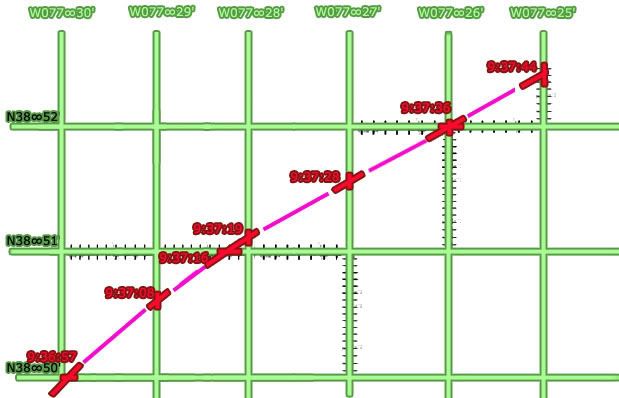
The number of seconds taken to pass a certain way is marked off on that axis, true heading (mag angles minus ten degrees) are marked at each crossing (red), with the rest of flight filled in between (magenta). In retrospect my grid is slightly uneven, giving a mild wiggle to the flight path – but all proportions, times, and locations otherwise line up – as usual not exact but close enough to see a clear and logical pattern.
Which becomes interesting when it tries to line up with real-world grid lines, mapped here with the same curve from above matched with the official final trajectory and impact point.

A literal mapping would make no sense, putting the path consistently about 20 miles off to the west via the massive longitudinal offset previously calculated at about 22 minutes (about 1/3 of a degree) – but here I took the west-offset arbitrarily as a whole-minute difference of 21' to match closest lines in the area - W077∞30' mapped over W077°09', etc. Any possible north offset was ignored, with latitude lines placed the same (38∞52' mapped as 38°52').
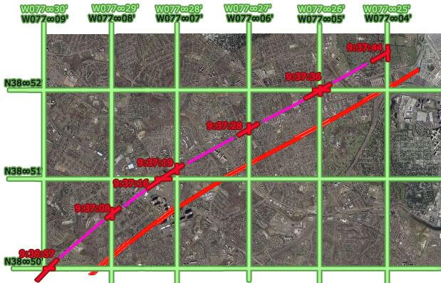
The flight paths don’t match up, evidencing a north deviation of approximately 20 seconds north of real. The west reading appears roughly on with the 21 minute offset, but on closer inspection syops a bit short. The exact end point is less clear; considering one second left from the csv's last frame 'till impact, about 3-4 seconds at current rate to reach Pentagon from 04 line, this puts the readings again around 20-25 geo seconds too far west.
Csv flight path and corresponding grid shifted to match official flight path:

The Offset is roughly square or perhaps proportionate to the rectangular parcels marked out here – about a third of a minute on each side. So the West offset is now set by me at about 21’20” West and 0’20” north.
Sunday, August 26, 2007
NTSB ANIMATION INTERNAL GEOGRAPHY, PART 4: LATITUDE COLOR TRACK
NTSB ANIMATION INTERNAL GEOGRAPHY, PART 4: LATITUDE COLOR TRACK
Adam Larson / Caustic Logic
The Frustrating Fraud
rough draft, last updated 8/29 early am
The Color Track System
The tedium of mapping out the otherwise-ignored and probably irrelevant global grid beneath the plane in the NTSB animation is finally paying off, and looking at the east-west latitude lines passed or paralleled on the screen, I’ve made some interesting discoveries.
I have identified eleven latitude lines of note that frame the flight’s north-south dimensions and run along its east-west axis. I color-coded each line individually tracing it, continuously through its flight. each line is verified at multiple points as contiguous, parallel to its neighbors, and having a steady relation to the evolving flight path/ground track – in generally far more parallel than is warranted for real-world latitude lines but a general good fit for lines oriented to magnetic north.
1-blue – northernmost, never crossed
2-violet – next line south
3-purple – the most consistently paralleled line on the outbound flight.
4-magenta
5-red
6-orange
7-yellow – actually the first line crossed at the runway
8 –green
9 – aqua – the most consistently paralleled line on the outbound flight.
10 –sky blue – southernmost line actually crossed
11 – dark blue (intermittent, never crossed)
 Here are lines 4-11 as seen at 9:07:39, headed more or less east (84 magnetic at this spot). Note that here on the south side, the exact lines at or near to north half flight path are not entirely clear. Lines 2 and three are there as well but unmarked due to lack of clarity. Reading the south path from north yields similar results, but there are better views that illustrate the color continuity.
To show how I tracked them, I’m imbedding a rudimentary “animation” of several dozen frames made in Photoshop of stills from the animation with the colored lines traced on. This is version 2, with another version or two to come before I call it good enough. The music is my own, from '99.
Initially what I saw was something like this over the full flight path:
 (new window for full size)
I think it's a bit wrong, arrived at by misreading the cross-points at the south turn slightly, and by copying the exact bend I had mapped out for line 3 (see below) for each line. But while this grid came close to explaining what the animation shows, there are some serious perspective issues at work, and the obvious point that there's no such bend visible in the onscreen "latitude lines." I'd guess a subtle curve would actually explain it better, but also started tinkering with some straight-line solutions. Straight lines visibly and logically make more sense, and are more likely correct. But compared to what's seen in the video, this one at least is off on significantly on several points.

Examples:
Yellow Track – Line 7

 Just to start, I’ve marked the ends of the color-coded latitude lines as the flight path turns sharply south around 8:55 am, just after the takeover. Eight of the 11 lines (lines 2-9) are crossed in this ominous maneuver roughly as mapped out below. Note where line 7 (yellow) crosses at the west end of the path, during the turn at about 8:58. Keep this location in mind as we shift attention to the other end(s) of the flight path.
 The yellow line continues down the middle of the space between the outbound and return flights. At the other end of the bent, elongated horseshoe flight path, the line still runs and is visible in both directions. Just after takeoff - 8:22 am the plane is paralleling line 7, line 8 visible to the left just north of the return flight ground track (and line 9 – aqua – is also there but not clear enough to mark), and 6 to the right. Perspective here is fierce, and the picture gets clearer as the plane gets higher.
 Here it is an hour later as it neared the same point; this is the bottleneck of the flight, where we can see an easier point for referencing the other side and establishing continuity. There are about 2.5 parcels marked out by three lines running between the two paths, and the angle is clear to see. If these are east-west lines, why is the plane angling to the right in both directions when it was supposed to be southwest then northeast, and should slant to the left?
Purple Track - Line 3
In the video above, watch from frames 12:34:48 to the south turn.The red line down the center is number 5, the magenta number 4, and purple is number 3, which is interesting to follow. It first passes under flight path at about 8:36, during northward turn. Line 2 (violet) is also barely passed a minute or so later and then paralleled, though the plane remains south of line 1 (blue) the whole time. Follow the track ahead a few frames, and notice that as the plane corrects back to the south it passes near line 3, but the ground track never again touches or crosses it until the south turn at the end there.
 In order for this single line to both cross during the north sweep and again as it turns south, at least as I’ve plotted those points, it could not be east-west in relation to the official flight path. The most logical conclusion is that it has a slant, shown here as the straight purple line. However, the ground track does not cross over or touch this line again in the animation between these two points, as it would at 8:47 if a straight slant. In fact it almost seems to bow around that point from slanted to true east-west. This may sound strange, but compare the straight slant to the bowed line with what’s seen in the animation and tell me if this doesn’t fit better. Or is the roughness of my graphics, like the placement of 8:47 plot, enough to throw this off and insinuate a bend?
---
Aqua/Sky Blue Track – lines 9 and 10
Line 9, coded aqua, is the one most closely paralleled on the return flight. The third southernmost line, it’s first intersected by the ground track around9:01. Line 10 (sky blue) is to its right (south), of course also closely paralelled. Together they frame its return flight. 9:00:39 - just after the south turn but straightening out to head east - lines 3-10 shown here – line 9 (aqua) is just south of the ground track here, but the plane soon crosses so it’s to the north, and then evens out and parallels right over for a while. The cross-point for line 9 is further out than it seems, and is clearly not parallel here (as I said in the video - above - will be fixed in version 3).
 Despite 20 minutes travel and a recorded northward turn, line 9 is still running parallel and near the ground track, which is only slowly approaching line 10 (sky blue). Now – heading slightly northeast (mag heading 90, 80 real) – should it be trending slightly south between “latitude lines?”

And finally tracing the lines through the final approach loop, we see that aqua line 9 is the one that crosses the Pentagon overlay map. I'm not able to match this with my path here without a final curve, but again, the red path is less than perfect (I had similar troubles matching up line 7 after takeoff). Either way, this rough intersection gives us an end point to draw a more precise track of lines 9 and 10.
 Looking for traight line solution, none seemed to work for all points. But I was able to soften the curve greatly and found the best fit, much better than my bent model above. On the whole it’s effectively straight, so I’m thinking now the lines are most likely straight but clearly slanted from reality. I keep seeing a curve if not a bend, but it's subtler than I thought,and possibly an illusion from my flight path graphics' imprecision (I have below corrected at least one small spot, placing 9:15 a few minutes further north to match the csv, which helps the straight lines fit). This graphic shows a curved version that works quite well along with the closest fit straight solution (lines slanted at about 83 degrees, seven degrees counter-clockwise from reality). Note the marginal difference.
---
To come: the final map of all lines that works best at all points then I am done with this stupid subject.
Then final grid analysis and overlay map rotation issues relative to that and then I'm really done.
Adam Larson / Caustic Logic
The Frustrating Fraud
rough draft, last updated 8/29 early am
The Color Track System
The tedium of mapping out the otherwise-ignored and probably irrelevant global grid beneath the plane in the NTSB animation is finally paying off, and looking at the east-west latitude lines passed or paralleled on the screen, I’ve made some interesting discoveries.
I have identified eleven latitude lines of note that frame the flight’s north-south dimensions and run along its east-west axis. I color-coded each line individually tracing it, continuously through its flight. each line is verified at multiple points as contiguous, parallel to its neighbors, and having a steady relation to the evolving flight path/ground track – in generally far more parallel than is warranted for real-world latitude lines but a general good fit for lines oriented to magnetic north.
1-blue – northernmost, never crossed
2-violet – next line south
3-purple – the most consistently paralleled line on the outbound flight.
4-magenta
5-red
6-orange
7-yellow – actually the first line crossed at the runway
8 –green
9 – aqua – the most consistently paralleled line on the outbound flight.
10 –sky blue – southernmost line actually crossed
11 – dark blue (intermittent, never crossed)
 Here are lines 4-11 as seen at 9:07:39, headed more or less east (84 magnetic at this spot). Note that here on the south side, the exact lines at or near to north half flight path are not entirely clear. Lines 2 and three are there as well but unmarked due to lack of clarity. Reading the south path from north yields similar results, but there are better views that illustrate the color continuity.
 To show how I tracked them, I’m imbedding a rudimentary “animation” of several dozen frames made in Photoshop of stills from the animation with the colored lines traced on. This is version 2, with another version or two to come before I call it good enough. The music is my own, from '99.
Initially what I saw was something like this over the full flight path:
 (new window for full size)
I think it's a bit wrong, arrived at by misreading the cross-points at the south turn slightly, and by copying the exact bend I had mapped out for line 3 (see below) for each line. But while this grid came close to explaining what the animation shows, there are some serious perspective issues at work, and the obvious point that there's no such bend visible in the onscreen "latitude lines." I'd guess a subtle curve would actually explain it better, but also started tinkering with some straight-line solutions. Straight lines visibly and logically make more sense, and are more likely correct. But compared to what's seen in the video, this one at least is off on significantly on several points.

Examples:
Yellow Track – Line 7
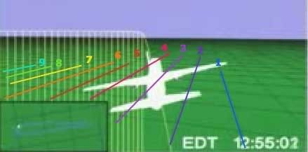
 Just to start, I’ve marked the ends of the color-coded latitude lines as the flight path turns sharply south around 8:55 am, just after the takeover. Eight of the 11 lines (lines 2-9) are crossed in this ominous maneuver roughly as mapped out below. Note where line 7 (yellow) crosses at the west end of the path, during the turn at about 8:58. Keep this location in mind as we shift attention to the other end(s) of the flight path.
 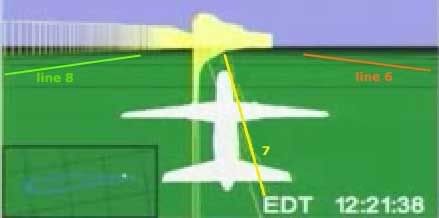 The yellow line continues down the middle of the space between the outbound and return flights. At the other end of the bent, elongated horseshoe flight path, the line still runs and is visible in both directions. Just after takeoff - 8:22 am the plane is paralleling line 7, line 8 visible to the left just north of the return flight ground track (and line 9 – aqua – is also there but not clear enough to mark), and 6 to the right. Perspective here is fierce, and the picture gets clearer as the plane gets higher.
 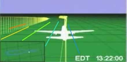 Here it is an hour later as it neared the same point; this is the bottleneck of the flight, where we can see an easier point for referencing the other side and establishing continuity. There are about 2.5 parcels marked out by three lines running between the two paths, and the angle is clear to see. If these are east-west lines, why is the plane angling to the right in both directions when it was supposed to be southwest then northeast, and should slant to the left?
 Purple Track - Line 3
In the video above, watch from frames 12:34:48 to the south turn.The red line down the center is number 5, the magenta number 4, and purple is number 3, which is interesting to follow. It first passes under flight path at about 8:36, during northward turn. Line 2 (violet) is also barely passed a minute or so later and then paralleled, though the plane remains south of line 1 (blue) the whole time. Follow the track ahead a few frames, and notice that as the plane corrects back to the south it passes near line 3, but the ground track never again touches or crosses it until the south turn at the end there.
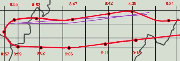 In order for this single line to both cross during the north sweep and again as it turns south, at least as I’ve plotted those points, it could not be east-west in relation to the official flight path. The most logical conclusion is that it has a slant, shown here as the straight purple line. However, the ground track does not cross over or touch this line again in the animation between these two points, as it would at 8:47 if a straight slant. In fact it almost seems to bow around that point from slanted to true east-west. This may sound strange, but compare the straight slant to the bowed line with what’s seen in the animation and tell me if this doesn’t fit better. Or is the roughness of my graphics, like the placement of 8:47 plot, enough to throw this off and insinuate a bend?
 ---
Aqua/Sky Blue Track – lines 9 and 10
Line 9, coded aqua, is the one most closely paralleled on the return flight. The third southernmost line, it’s first intersected by the ground track around9:01. Line 10 (sky blue) is to its right (south), of course also closely paralelled. Together they frame its return flight.
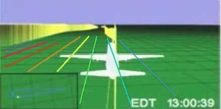 9:00:39 - just after the south turn but straightening out to head east - lines 3-10 shown here – line 9 (aqua) is just south of the ground track here, but the plane soon crosses so it’s to the north, and then evens out and parallels right over for a while. The cross-point for line 9 is further out than it seems, and is clearly not parallel here (as I said in the video - above - will be fixed in version 3).
  Despite 20 minutes travel and a recorded northward turn, line 9 is still running parallel and near the ground track, which is only slowly approaching line 10 (sky blue). Now – heading slightly northeast (mag heading 90, 80 real) – should it be trending slightly south between “latitude lines?”
And finally tracing the lines through the final approach loop, we see that aqua line 9 is the one that crosses the Pentagon overlay map. I'm not able to match this with my path here without a final curve, but again, the red path is less than perfect (I had similar troubles matching up line 7 after takeoff). Either way, this rough intersection gives us an end point to draw a more precise track of lines 9 and 10.
 Looking for traight line solution, none seemed to work for all points. But I was able to soften the curve greatly and found the best fit, much better than my bent model above. On the whole it’s effectively straight, so I’m thinking now the lines are most likely straight but clearly slanted from reality. I keep seeing a curve if not a bend, but it's subtler than I thought,and possibly an illusion from my flight path graphics' imprecision (I have below corrected at least one small spot, placing 9:15 a few minutes further north to match the csv, which helps the straight lines fit). This graphic shows a curved version that works quite well along with the closest fit straight solution (lines slanted at about 83 degrees, seven degrees counter-clockwise from reality). Note the marginal difference.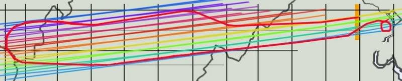
---
To come: the final map of all lines that works best at all points then I am done with this stupid subject.
Then final grid analysis and overlay map rotation issues relative to that and then I'm really done.
Saturday, August 25, 2007
BARBARA HONEGGER
THE PSYCHIC MUNCHKIN BEHIND THE HOLY GRAIL
Adam Larson
Caustic Logic/The Frustrating Fraud
December 15 2006
Perhaps the oddest case in the small but fertile world of government functionary-9/11 Truth crossover is that of Barbara Honegger, a dedicated but elusive and little seen 9/11 warrior with murky roots (apparently military and intelligence). She was allegedly into weird parapsychic stuff, channeling voices of supercomputers from the future and whatnot, [1] before she went to work in the late 1970s for a rising star named Martin Anderson at the Hoover Institute (where he remains as a Senior Fellow). She then followed Anderson to the White House as an assistant to join the Reagan-Bush transition team in 1980. Anderson advised Reagan on everything from foreign intelligence to education, finance, and arms control, probably worked for Bush sr., and during the Clinton Years focused on teaching classes at Stanford (home of the Hoover Institute and where Condi Rice was briefly provost). Anderson was later an advisor to George W. Bush in his 2000 presidential campaign, [2] and eventually became a member of Rumsfeld’s influential Defense Policy Board in 2001. [3]
Honegger herself had split off from her Republican benefactors early; she only served the Reagan White House as a researcher and policy analyst until she resigned in 1983 under unclear circumstances – either over sexual discrimination or something else. In May 1985 Newsweek ran a piece on Honegger titled “The Munchkin's Musical” that stated “White House aides began whispering that Honegger was a believer in ESP who claimed she'd ridden on Halley's comet.” [4]
At the time she was also among the first to have leaked details of the “October Surprise” scandal, much of which was later verified by numerous involved parties. The deal was allegedly made by George Bush and William Casey to delay the release of the hostages in Iran - a delay that cost Carter the White House and gained it for Reagan and Bush. [5] Her charges culminated with the 1989 book “October Surprise,” predating Gary Sick’s work of the same name (which does not mention her) by two years. In the end, the scandal cost Reagan nothing, covered up by an investigation headed by a certain Lee Hamilton, who would go on later to 9/11 Commission and Iraq Study Group fame. Honegger later left a small mark on the Iran-Contra scandal, carried out as it was by largely the same networks responsible for the October Surprise, continuing to weave a picture of Bush-centered intrigue.
Despite all this, she not only remained alive but went on to tie Bush's son and former Defense Secretary in with carrying out 9/11, her works on which carry the disclaimer "all of Honegger’s research and publications on September 11 are solely in her capacity as a concerned private citizen and do not imply official endorsement." This is because in 1995 she was given a cushy job as Senior Military Affairs Journalist at the Naval Postgraduate School, which she holds till the present, writing about such things as a cyber-defense exercise in 2002: “all the National Security Agency’s Trojan horses and Air Force and Army’s info-warriors couldn’t break through the cyber walls erected by the Naval Postgraduate School’s ace “Blue” Team,” she wrote. [6] How ironic then that what some suspect of being NSA Trojan horse 9/11 arguments should have eventually broken through her psychic shields and into her research.
Honegger’s role in the 9/11 Truth movement is huge and will perhaps go down as her crowning achievement, for good or ill. Her legacy here is centered on revealing to Mike Ruppert inside info on the War Games of 9/11 which scrambled the defense and were probably co-ordinated by a Maestro working for Dick Cheney. These revelations formed what Ruppert called “in my opinion – the holy grail of 9/11 research,” and a key point for the smarter edge of the movement at large. [7] Her credentials thus seem solid, but her later works I’ve seen are sloppy and full of holes and leaps. In October 2004 she reportedly told a forum in Los Angeles that “shoe bomber” Richard Reid was really Osama bin Laden, who apparently dyed his hair, trimmed his beard, removed a few wrinkles and turned himself in as it were by trying to ignite his shoes on a trans-Atlantic flight. [8]
Honegger’s later works include "The Pentagon Attack Papers," published as an appendix in Jim Marrs’ “The Terror Conspiracy,” 2006, taking her squarely into this blog's turf. In her Pentagon analysis, she argued against a big plane and for a traditional bombing. This, she's certain, happened at 9:32, with anything happening at the official time of 9:37 being some sort of cover – possibly the impact of “an airborne object significantly smaller than […] a Boeing 757.” She cites a mixed bag of evidence, from hard fact like a stopped clock to repeated government “slips” to irrelevant coincidences, and has cited war games at the Pentagon that morning, which are unverifiable but likely incorrect. [9] (I will post on this theory in more detail sometime soon).
She has also tied the alleged original pilot of Flight 77 before it was hijacked, Captain Charles Burlingame, to “a Task Force that drafted the Pentagon's emergency response plan on what to do in case a plane hit the building.” She appears to be the source of the similar charge laid out in Loose Change, second edition’s opening segment. It’s an intriguing possibility, but it doesn’t help her tentative case that she then finds it “extremely likely, if not certain - that this 'task force' that […] Burlingame was part of was the Cheney counterterrorism preparedness task force, and that the Pentagon plane pilot, therefore, directly knew and even worked with/for Cheney.” [10] Maybe that parapsychic training is helping her to fill in the gaps with right-brain impulses or insights from the future that make it all make sense…
No more promising is her citation of “the already legion evidence that Flight 77 did not hit the Pentagon:" “the small hole in the west side of the Pentagon being not nearly large enough for the plane’s fuselage, let alone wing width," "no damage to the lawn where Flight 77 allegedly struck and skidded before hitting the building," "wrecked plane parts at the site identified as being from an A-3 Sky Warrior, a far smaller plane than that of Flight 77, a Boeing 757.” [11] Of course my debunkings are legion as well, or getting there. "The small hole" - the unmarked lawn - the plane parts - The A3 Sky Warrior Theory.
While her reputation in the movement is generally sterling and I don’t know enough to cast large stones, these aspects of Honegger’s works – her unexplained leaps, need to tie Cheney in personally, and especially disagreeing with me over the Pentagon evidence - are deeply flawed. Whatever her intentions, she has served as a useful and strangely credible-seeming source, and also a comet-riding psychic moonbat in the employ of the US military pushing among the worst 9/11 theories. That doesn't prove anything but it's worth considering.
Sources:
[1] http://www.mindcontrolforums.com/mindnet/mn202b.htm
[2] “2001: Mr. Hoover Goes to Washington?” Myszewski, David. Stanford Review. Volume XXV, Issue 6: January 2001
http://www.stanfordreview.org/Archive/Volume_XXVII/Issue_7/2001/
[3] Martin Anderson: Keith and Jan Hurlbut Senior Fellow. http://www.hoover.org/bios/anderson
[4] Source lost... I'll check at the library and get back...
[5] http://www.spartacus.schoolnet.co.uk/JFKhonegger.htm
[6] Honegger, Barbara. “NPS Aces Second Annual DoD Cyber Defense Exercise.” http://www.nps.navy.mil/PAO/Internal/Cyber_Defense.htm
[7] Ruppert, page 336.
[8] Propaganda Patterns: Official Stories, Limited Hang Outs, Best Evidence, Distracting Disinformation
a political map of political collapse and possibilities. http://www.oilempire.us/propaganda.html
[9] Honegger, Barbara. “THE PENTAGON ATTACK PAPERS: Seven Hours in September: The Clock that Broke the Lie”
Appendix to THE TERROR CONSPIRACY by Jim Marrs. Publication date, Sept. 6, 2006 http://johnmccarthy90066.tripod.com/id206.html
[10] "War Games" by the US military on 9/11: paralysis of air defenses that ensured the success of the attacks? who coordinated these efforts?” http://www.oilempire.us/wargames.html
[11] See [9].
Adam Larson
Caustic Logic/The Frustrating Fraud
December 15 2006
Perhaps the oddest case in the small but fertile world of government functionary-9/11 Truth crossover is that of Barbara Honegger, a dedicated but elusive and little seen 9/11 warrior with murky roots (apparently military and intelligence). She was allegedly into weird parapsychic stuff, channeling voices of supercomputers from the future and whatnot, [1] before she went to work in the late 1970s for a rising star named Martin Anderson at the Hoover Institute (where he remains as a Senior Fellow). She then followed Anderson to the White House as an assistant to join the Reagan-Bush transition team in 1980. Anderson advised Reagan on everything from foreign intelligence to education, finance, and arms control, probably worked for Bush sr., and during the Clinton Years focused on teaching classes at Stanford (home of the Hoover Institute and where Condi Rice was briefly provost). Anderson was later an advisor to George W. Bush in his 2000 presidential campaign, [2] and eventually became a member of Rumsfeld’s influential Defense Policy Board in 2001. [3]
 |
At the time she was also among the first to have leaked details of the “October Surprise” scandal, much of which was later verified by numerous involved parties. The deal was allegedly made by George Bush and William Casey to delay the release of the hostages in Iran - a delay that cost Carter the White House and gained it for Reagan and Bush. [5] Her charges culminated with the 1989 book “October Surprise,” predating Gary Sick’s work of the same name (which does not mention her) by two years. In the end, the scandal cost Reagan nothing, covered up by an investigation headed by a certain Lee Hamilton, who would go on later to 9/11 Commission and Iraq Study Group fame. Honegger later left a small mark on the Iran-Contra scandal, carried out as it was by largely the same networks responsible for the October Surprise, continuing to weave a picture of Bush-centered intrigue.
Despite all this, she not only remained alive but went on to tie Bush's son and former Defense Secretary in with carrying out 9/11, her works on which carry the disclaimer "all of Honegger’s research and publications on September 11 are solely in her capacity as a concerned private citizen and do not imply official endorsement." This is because in 1995 she was given a cushy job as Senior Military Affairs Journalist at the Naval Postgraduate School, which she holds till the present, writing about such things as a cyber-defense exercise in 2002: “all the National Security Agency’s Trojan horses and Air Force and Army’s info-warriors couldn’t break through the cyber walls erected by the Naval Postgraduate School’s ace “Blue” Team,” she wrote. [6] How ironic then that what some suspect of being NSA Trojan horse 9/11 arguments should have eventually broken through her psychic shields and into her research.
Honegger’s role in the 9/11 Truth movement is huge and will perhaps go down as her crowning achievement, for good or ill. Her legacy here is centered on revealing to Mike Ruppert inside info on the War Games of 9/11 which scrambled the defense and were probably co-ordinated by a Maestro working for Dick Cheney. These revelations formed what Ruppert called “in my opinion – the holy grail of 9/11 research,” and a key point for the smarter edge of the movement at large. [7] Her credentials thus seem solid, but her later works I’ve seen are sloppy and full of holes and leaps. In October 2004 she reportedly told a forum in Los Angeles that “shoe bomber” Richard Reid was really Osama bin Laden, who apparently dyed his hair, trimmed his beard, removed a few wrinkles and turned himself in as it were by trying to ignite his shoes on a trans-Atlantic flight. [8]
Honegger’s later works include "The Pentagon Attack Papers," published as an appendix in Jim Marrs’ “The Terror Conspiracy,” 2006, taking her squarely into this blog's turf. In her Pentagon analysis, she argued against a big plane and for a traditional bombing. This, she's certain, happened at 9:32, with anything happening at the official time of 9:37 being some sort of cover – possibly the impact of “an airborne object significantly smaller than […] a Boeing 757.” She cites a mixed bag of evidence, from hard fact like a stopped clock to repeated government “slips” to irrelevant coincidences, and has cited war games at the Pentagon that morning, which are unverifiable but likely incorrect. [9] (I will post on this theory in more detail sometime soon).
She has also tied the alleged original pilot of Flight 77 before it was hijacked, Captain Charles Burlingame, to “a Task Force that drafted the Pentagon's emergency response plan on what to do in case a plane hit the building.” She appears to be the source of the similar charge laid out in Loose Change, second edition’s opening segment. It’s an intriguing possibility, but it doesn’t help her tentative case that she then finds it “extremely likely, if not certain - that this 'task force' that […] Burlingame was part of was the Cheney counterterrorism preparedness task force, and that the Pentagon plane pilot, therefore, directly knew and even worked with/for Cheney.” [10] Maybe that parapsychic training is helping her to fill in the gaps with right-brain impulses or insights from the future that make it all make sense…
No more promising is her citation of “the already legion evidence that Flight 77 did not hit the Pentagon:" “the small hole in the west side of the Pentagon being not nearly large enough for the plane’s fuselage, let alone wing width," "no damage to the lawn where Flight 77 allegedly struck and skidded before hitting the building," "wrecked plane parts at the site identified as being from an A-3 Sky Warrior, a far smaller plane than that of Flight 77, a Boeing 757.” [11] Of course my debunkings are legion as well, or getting there. "The small hole" - the unmarked lawn - the plane parts - The A3 Sky Warrior Theory.
While her reputation in the movement is generally sterling and I don’t know enough to cast large stones, these aspects of Honegger’s works – her unexplained leaps, need to tie Cheney in personally, and especially disagreeing with me over the Pentagon evidence - are deeply flawed. Whatever her intentions, she has served as a useful and strangely credible-seeming source, and also a comet-riding psychic moonbat in the employ of the US military pushing among the worst 9/11 theories. That doesn't prove anything but it's worth considering.
Sources:
[1] http://www.mindcontrolforums.com/mindnet/mn202b.htm
[2] “2001: Mr. Hoover Goes to Washington?” Myszewski, David. Stanford Review. Volume XXV, Issue 6: January 2001
http://www.stanfordreview.org/Archive/Volume_XXVII/Issue_7/2001/
[3] Martin Anderson: Keith and Jan Hurlbut Senior Fellow. http://www.hoover.org/bios/anderson
[4] Source lost... I'll check at the library and get back...
[5] http://www.spartacus.schoolnet.co.uk/JFKhonegger.htm
[6] Honegger, Barbara. “NPS Aces Second Annual DoD Cyber Defense Exercise.” http://www.nps.navy.mil/PAO/Internal/Cyber_Defense.htm
[7] Ruppert, page 336.
[8] Propaganda Patterns: Official Stories, Limited Hang Outs, Best Evidence, Distracting Disinformation
a political map of political collapse and possibilities. http://www.oilempire.us/propaganda.html
[9] Honegger, Barbara. “THE PENTAGON ATTACK PAPERS: Seven Hours in September: The Clock that Broke the Lie”
Appendix to THE TERROR CONSPIRACY by Jim Marrs. Publication date, Sept. 6, 2006 http://johnmccarthy90066.tripod.com/id206.html
[10] "War Games" by the US military on 9/11: paralysis of air defenses that ensured the success of the attacks? who coordinated these efforts?” http://www.oilempire.us/wargames.html
[11] See [9].
Friday, August 24, 2007
CSV / ANIMATION / OFFICIAL FLIGHT PATH AGREEMENT
CSV / ANIMATION / OFFICIAL FLIGHT PATH AGREEMENT
Adam Larson / Caustic Logic
The Frustrating Fraud
August 24 2007
A small post to tide my swarming readers over until I finish my animation geography analysis; I recently found, for what it’s worth, both the animation and the csv file seem to agree with the official story [ed - on this issue - the general flight path]. This is nothing new, of course, but barring minor variations of whatever significance, and looking at the 320-mile long swathe of land flown over by Flight 77, it’s all a remarkable fit.
Earthtools tells me the furthest point west in the official path is about 82° 44' 56” W, while the csv file records 83°06’ as the largest west number. These two numbers are off by about 21-22 minutes (no seconds recorded in the csv so exact margin cannot be determined), or about the margin they’re off by for the whole flight (explained here). So the official story and the csv file (corrected) match on lat/long readings at the furthest point west, and they also match at Dulles and the Pentagon; by being about 22 degrees apart across the board, they verify the board. As for the animation, I ignored its apparent lat/long grid appearing consistently off, and just used it to place the plane roughly at given times on its flight path (for example, just before a left turn at 8:39).

I made this map by stretching the 9/11 Commission’s flight path map w/state borders to fit a larger map of those borders. I then recreated the path (a bit rough in the curves) for greater clarity. I set the lat/long grid lines beneath it with Earthtools. Along the flight path, I marked 19 timed locations at key times. These were first plotted visually according to the animation, and then fine-tuned with the csv file (west corrected).
Note the remarkable, if not exact, correlation of all these data sets. The plots are off by a few minutes here and there, but on the scale of this 320-mile long swathe it all generally lines up. This is not surprising of course, as the Commission’s map and the official story in general have always relied on the flight path first downloaded we’re told within days of the attack. Just take this as another verification that the official data all lines up on the big picture flight path issue, and another excuse for me to publish a cool new graphic.
Adam Larson / Caustic Logic
The Frustrating Fraud
August 24 2007
A small post to tide my swarming readers over until I finish my animation geography analysis; I recently found, for what it’s worth, both the animation and the csv file seem to agree with the official story [ed - on this issue - the general flight path]. This is nothing new, of course, but barring minor variations of whatever significance, and looking at the 320-mile long swathe of land flown over by Flight 77, it’s all a remarkable fit.
Earthtools tells me the furthest point west in the official path is about 82° 44' 56” W, while the csv file records 83°06’ as the largest west number. These two numbers are off by about 21-22 minutes (no seconds recorded in the csv so exact margin cannot be determined), or about the margin they’re off by for the whole flight (explained here). So the official story and the csv file (corrected) match on lat/long readings at the furthest point west, and they also match at Dulles and the Pentagon; by being about 22 degrees apart across the board, they verify the board. As for the animation, I ignored its apparent lat/long grid appearing consistently off, and just used it to place the plane roughly at given times on its flight path (for example, just before a left turn at 8:39).
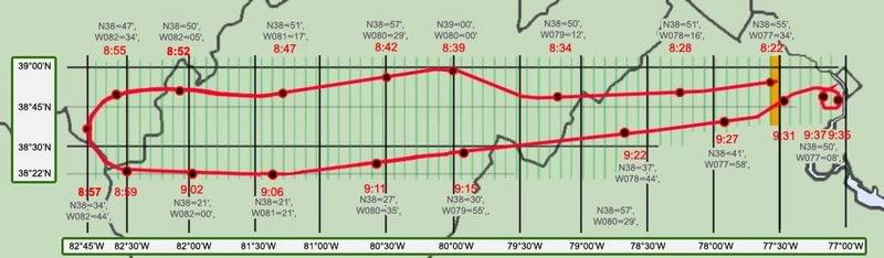
I made this map by stretching the 9/11 Commission’s flight path map w/state borders to fit a larger map of those borders. I then recreated the path (a bit rough in the curves) for greater clarity. I set the lat/long grid lines beneath it with Earthtools. Along the flight path, I marked 19 timed locations at key times. These were first plotted visually according to the animation, and then fine-tuned with the csv file (west corrected).
Note the remarkable, if not exact, correlation of all these data sets. The plots are off by a few minutes here and there, but on the scale of this 320-mile long swathe it all generally lines up. This is not surprising of course, as the Commission’s map and the official story in general have always relied on the flight path first downloaded we’re told within days of the attack. Just take this as another verification that the official data all lines up on the big picture flight path issue, and another excuse for me to publish a cool new graphic.
Tuesday, August 21, 2007
NTSB ANIMATION INTERNAL GEOGRAPHY, PART 3: GRID CLUES: ORIENTATION AND PROPORTIONS
NTSB ANIMATION INTERNAL GEOGRAPHY, PART 3: GRID CLUES: ORIENTATION AND PROPORTIONS
Adam Larson / Caustic Logic
The Frustrating Fraud
August 21 2007
last updated 8/22, 1:00 pm
I had promised a piece on the grid's "latitudelines," but that one will take a little more work and could use some foreshadowing, and so here are four clues to what I'm starting to decide on...
Regarding the background grid of the NTSB's Flight 77 animation, the questions of rectangular parcel proportions and overall northern orientation are closely related. Wondering how it’s oriented may seem silly; one would presume the Safety Board’s experts, if not the FDR itself, would correct what the compass knows and show the plane on a true east-west north-south grid, with the magnetic headings showing up off from these (to almost exactly ten degrees) as they would have in real life. This does not seem to be the case.
Four clues:
1) Mini-master map:
 the full flight path is reproduced in the small window at the lower left of the animation screen and offers clues to both proportions and slope. Here is a screen cap with enhanced lines vs. official flight and real lat-long lines crossed. The animation seems to stretch the flight path over almost three squares. Undertow pointed this out to me, though I’d noticed it before, and it’s definitely a possible clue. If these mark some amalgamation of the onscreen rectangles, they should have the same proportions as those smaller parcels. That is, if a block of say 60 minutes by 60 minutes is square, a one-by-one minute unit should also be square. There is also, obviously, an angular slope evident between the two; the lower portion, again, shows the true east-west orientation of the official path, while the grid lines around the animation’s mini-map are rotated about 8-9 degrees counter-clockwise, just about consistent with magnetic north (declination 10.08 degrees).
2) lines at 270°
 At 8:22 am the plane has a heading (nosecone orientation) of 270 degrees - due west from magnetic north, just southwest of west in true terms. It's just about parallel with the nearest latitude-looking line, and perpedicular to the longitude lines ahead. As for parcel proportions, they look fairly square here. However, perspective at this fairly low altitude of 5137 feet is fierce and makes it unclear and inconclusive.
3) Lines at 180°
 As the plane nears the mid-point of its southward turn, at 8:57, the longitude line under it shows exactly vertical, and latitudes ahead of it exactly horizontal. The heading dia shows 180, or due south. This would make perfect sense if the grid were oriented to magnetic north. These rectangles also look remarkably square seen from an elevation of over 35,000 feet, as opposed to the roughly 5:7 proportions of latitude/longitude intersections there in the real world.
4) Lines at 70°
 I wanted to analyze the final trajectory shown in the animation in relation to the global map, but found that harder than due west and south. To start with, here is a frame with grid lines, Pentagon location, and track (flight path along the ground) highlighted. The magnetic dial hovers right around 70° from north on this final track.

At right is another view from just before the grand loop show just where on that parcel’s west edge the ground track crosses. I figured If I marked this and de-skewed the parcel I could masure its angle of incidence.

To measure this angle for sure, I’d need to know the proportions of the rectangles, something made difficult by the foreshortened perspective. Again this looks fairly square to me, so just on a hunch I ignored real-world lines and tried de-skewing the grid there into a square. This is all a bit approximate, so don’t expect precision to more than a degree or two.
Interestingly enough, we get almost exactly 70 degrees, which is what the FDR says on that path (both in the CSV file and the animation’s heading dial). Subtracting 10 degrees for magnetic declination, we have the official trajectory of 60 that matches the physical damage.
On all four points above, the flight path reads correct in angles relative to its own internal geography, but not to real-world lines, in either placement or slope. From this, my best guess at the moment is that the animation program is pointing its longitude lines to magnetic north, and its latitudes perpendicular to that, throwing the whole grid off by a rotation of approximately ten degrees. And on top of that, it's generating a square grid map, unlike real-world lines, in which latitude lines are further apart than longitudes. This equilateral proportion indicates the flight path may've been rendered at some default equator on this globe rather than at the proper latitude. If the lines even represent latitudes and longitudes at all and not some other type of grid.
To see whether this is confirmed or denied by the latitude lines involved, I will be posting a detailed piece soon and even a short "video." In fact this is already up on Youtube and viewable at this link. Sorry for the low resolution and the choppiness of my frames. I hope it works - compare to the original animation if that helps.
Adam Larson / Caustic Logic
The Frustrating Fraud
August 21 2007
last updated 8/22, 1:00 pm
I had promised a piece on the grid's "latitudelines," but that one will take a little more work and could use some foreshadowing, and so here are four clues to what I'm starting to decide on...
Regarding the background grid of the NTSB's Flight 77 animation, the questions of rectangular parcel proportions and overall northern orientation are closely related. Wondering how it’s oriented may seem silly; one would presume the Safety Board’s experts, if not the FDR itself, would correct what the compass knows and show the plane on a true east-west north-south grid, with the magnetic headings showing up off from these (to almost exactly ten degrees) as they would have in real life. This does not seem to be the case.
Four clues:
1) Mini-master map:
 the full flight path is reproduced in the small window at the lower left of the animation screen and offers clues to both proportions and slope. Here is a screen cap with enhanced lines vs. official flight and real lat-long lines crossed. The animation seems to stretch the flight path over almost three squares. Undertow pointed this out to me, though I’d noticed it before, and it’s definitely a possible clue. If these mark some amalgamation of the onscreen rectangles, they should have the same proportions as those smaller parcels. That is, if a block of say 60 minutes by 60 minutes is square, a one-by-one minute unit should also be square. There is also, obviously, an angular slope evident between the two; the lower portion, again, shows the true east-west orientation of the official path, while the grid lines around the animation’s mini-map are rotated about 8-9 degrees counter-clockwise, just about consistent with magnetic north (declination 10.08 degrees).
 2) lines at 270°
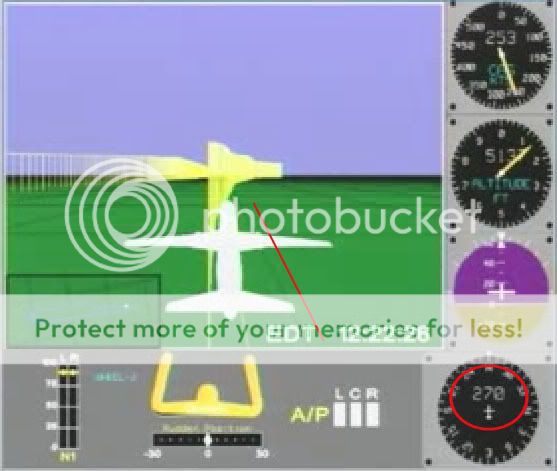 At 8:22 am the plane has a heading (nosecone orientation) of 270 degrees - due west from magnetic north, just southwest of west in true terms. It's just about parallel with the nearest latitude-looking line, and perpedicular to the longitude lines ahead. As for parcel proportions, they look fairly square here. However, perspective at this fairly low altitude of 5137 feet is fierce and makes it unclear and inconclusive.
 3) Lines at 180°
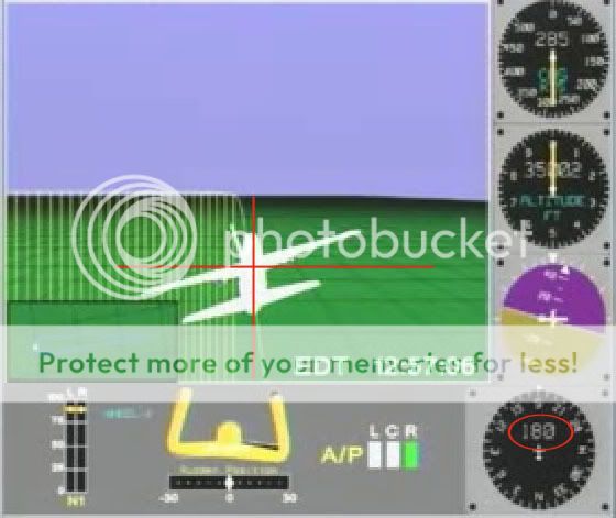 As the plane nears the mid-point of its southward turn, at 8:57, the longitude line under it shows exactly vertical, and latitudes ahead of it exactly horizontal. The heading dia shows 180, or due south. This would make perfect sense if the grid were oriented to magnetic north. These rectangles also look remarkably square seen from an elevation of over 35,000 feet, as opposed to the roughly 5:7 proportions of latitude/longitude intersections there in the real world.
 4) Lines at 70°
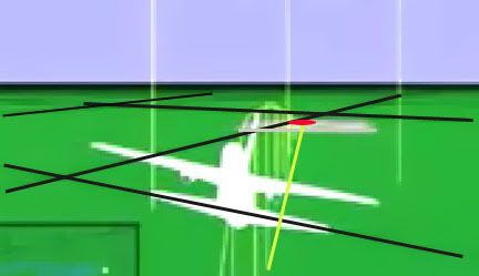 I wanted to analyze the final trajectory shown in the animation in relation to the global map, but found that harder than due west and south. To start with, here is a frame with grid lines, Pentagon location, and track (flight path along the ground) highlighted. The magnetic dial hovers right around 70° from north on this final track.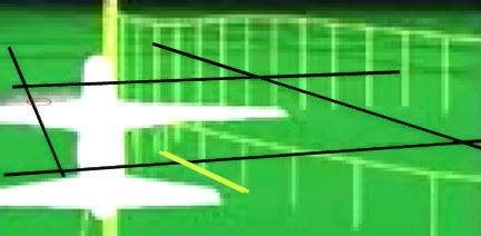
At right is another view from just before the grand loop show just where on that parcel’s west edge the ground track crosses. I figured If I marked this and de-skewed the parcel I could masure its angle of incidence.

To measure this angle for sure, I’d need to know the proportions of the rectangles, something made difficult by the foreshortened perspective. Again this looks fairly square to me, so just on a hunch I ignored real-world lines and tried de-skewing the grid there into a square. This is all a bit approximate, so don’t expect precision to more than a degree or two.
Interestingly enough, we get almost exactly 70 degrees, which is what the FDR says on that path (both in the CSV file and the animation’s heading dial). Subtracting 10 degrees for magnetic declination, we have the official trajectory of 60 that matches the physical damage.
On all four points above, the flight path reads correct in angles relative to its own internal geography, but not to real-world lines, in either placement or slope. From this, my best guess at the moment is that the animation program is pointing its longitude lines to magnetic north, and its latitudes perpendicular to that, throwing the whole grid off by a rotation of approximately ten degrees. And on top of that, it's generating a square grid map, unlike real-world lines, in which latitude lines are further apart than longitudes. This equilateral proportion indicates the flight path may've been rendered at some default equator on this globe rather than at the proper latitude. If the lines even represent latitudes and longitudes at all and not some other type of grid.
To see whether this is confirmed or denied by the latitude lines involved, I will be posting a detailed piece soon and even a short "video." In fact this is already up on Youtube and viewable at this link. Sorry for the low resolution and the choppiness of my frames. I hope it works - compare to the original animation if that helps.
Subscribe to:
Posts (Atom)


